Plate Tectonics Review Earths Interior Alfred Wegener 1880


 - German astronomer/meteorologist - Proposed Continental Drift in 1912")


 - Sea-Floor Spreading")


- Slides: 31
Plate Tectonics
Review Earth’s Interior
Alfred Wegener (1880 -1930) - German astronomer/meteorologist - Proposed Continental Drift in 1912
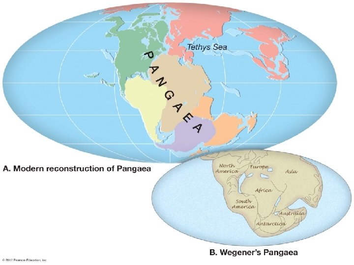
Theory of Continental Drift - Continental Drift • Earth’s continents had once been joined as a single landmass called Pangaea “all lands” • Broke apart 220 million years ago.
Pangaea Ultima?
Evidence from Rock Formations - Same rocks are found in the Appalachians, Greenland Europe.
Evidence from Fossils - Wegener found similar fossils of different land animals and plants on separated continents.
Paleaoclimatology Evidence - Coal • Coal forms from dead swamp plants. • Coal was found in Antarctica, therefore Antarctica must have been closer to the equator at one time.
More Paleaoclimatology Evidence - Glacial Deposits • 290 mya glacial deposits found in Africa, India, Australia, and South America.
Continental Drift was rejected. - Scientists rejected the hypothesis because: • People believed continents and ocean basins were fixed features. • Wegener could not explain what forces could cause a continent to move.
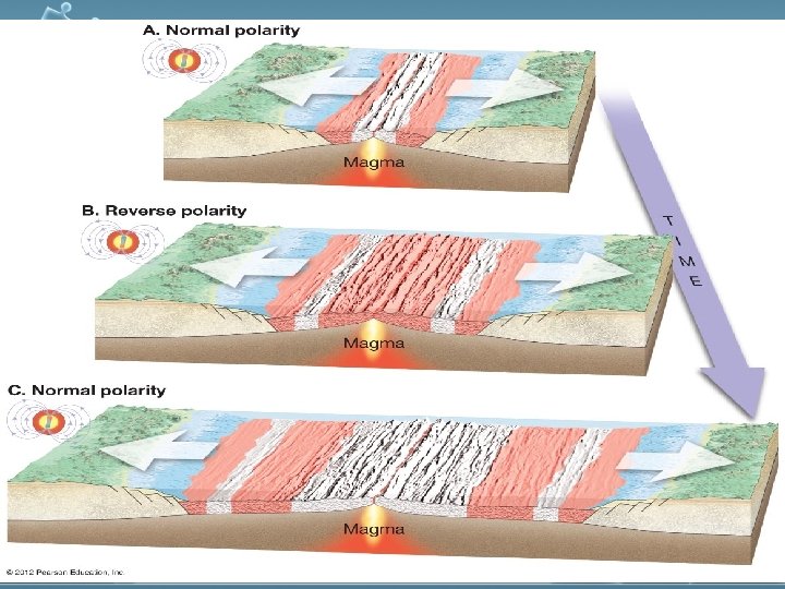
Theory of Plate Tectonics (1960) - Sea-Floor Spreading
New Technology - 1960 s Technology: • Magnetometer –map changes in magnetic fields. • Sonar – used to map out the seafloor (found mid-ocean ridge). • Radiometric Dating – ages the rocks.
Theory of Plate Tectonics Evidence Rock Age 1. • • • Young Rocks –near ocean ridges. Older Rocks –near deep-sea trenches Seafloor Age – oldest part = 180 million years old. Oldest Continental crust = 3. 8 billion years old. 2. Paleomagnetism • Investigated in ocean crust. • Shows that iron alignment has switched many times in past due to Earth’s magnetic reversals, supporting movement of continents.
Major plates of the world.
Mechanism of Plate movement -Slab-pull and Convection.
Mid-ocean Ridge – crust is formed.
Subduction Zone – crust is destroyed.
Plate Boundaries Three Major Types 1. Convergent • plates come together. 2. Divergent • plates move away from one another. 3. Transform • plates move horizontally past one another - places where tectonic plates interact with one another.
Divergent Boundary
Divergent - Iceland Rift
Convergent Oceanic. Continental Boundary
Oceanic-Continental Cascade Range
Cascade Range Volcanoes
Convergent Oceanicoceanic Boundary
Convergent Continent Boundary
Continental-Continental Himalayas
Transform Boundary
Transform – San Andreas Fault
Know this drawing!