Plate Tectonics Plate Tectonic Rock Cycle A series


 describes a decrease")


- Slides: 52
Plate Tectonics Plate Tectonic
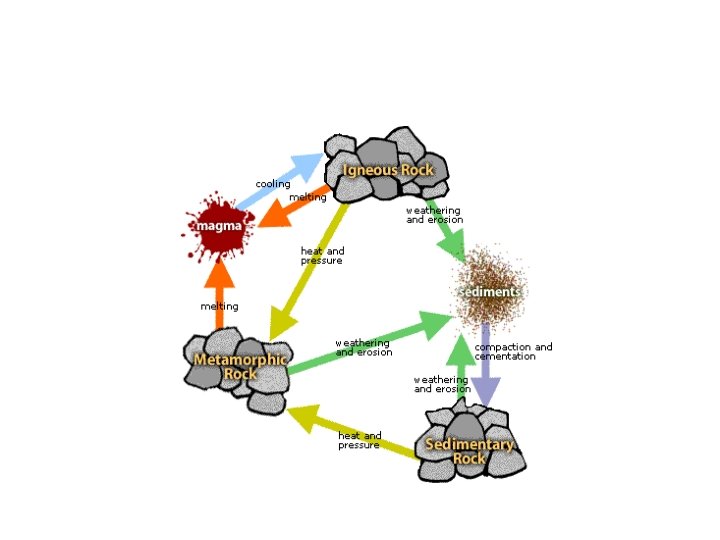
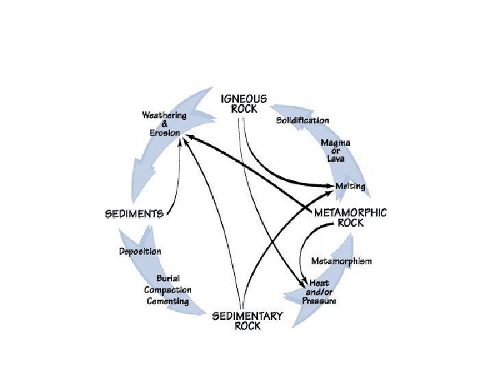
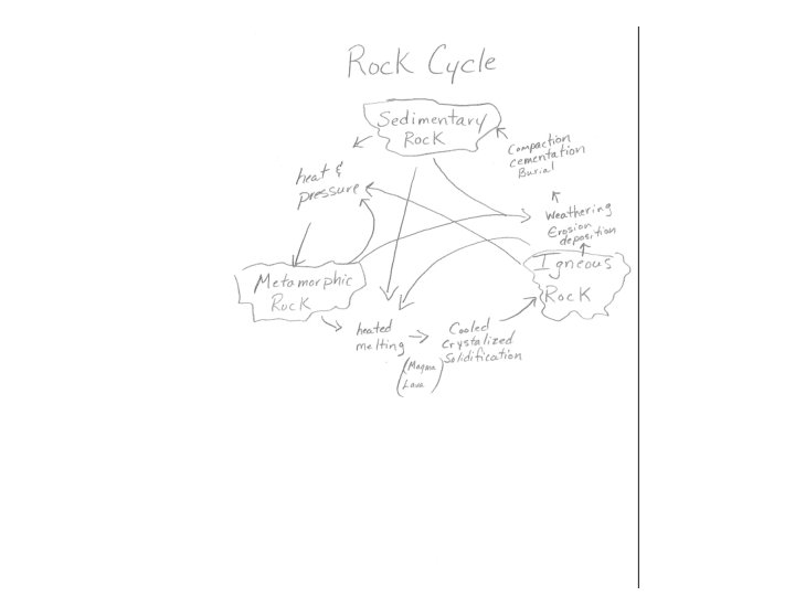
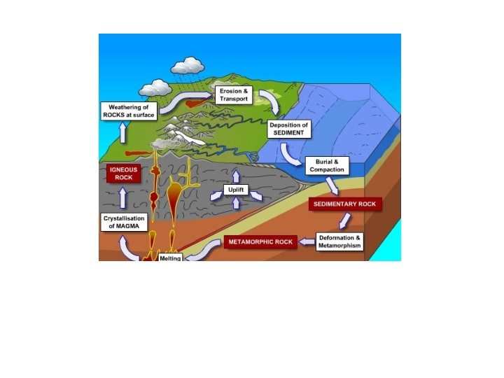
Rock Cycle A series of processes on the surface and inside Earth that slowly changes rocks from one kind to another. Some of these processes are directly related to thermal energy and forces in the mantle that drive plate motions.
Rock Cycle
Geology The science that examines the earth, its form and composition, and the changes which it has undergone and is undergoing.
WHY IS AN UNDERSTANDING OF GEOLOGY IMPORTANT TO ME? The Earth is where we live. We are dependent upon our Earth. Our water supply and our farm land formed by geologic processes. All our minerals, fuels, and construction materials come from the Earth’s crust. The Earth will remain a nice place to live if we use our resources wisely and control our wastes and garbage. There are natural earth hazards like floods, landslides, earthquakes, and volcanic eruptions. The understanding of geology can lead us to the safest areas in which to build cities, dams, schools, or roads and tunnels. If we understand geologic processes we will know the best places to dispose of our wastes and garbage, and the best geologic environments for finding oil, gas, and coal. If we understand geology we can learn ways to use the resources of the Earth and at the same time protect it from harm.
Constructive Process A force that builds up mountains and landmasses on Earth’s surface. (Deposition, mountain building, and volcanoes)
Destructive Process A force that slowly wears away mountains and other features on the surface of the Earth. (Weathering, erosion, glaciers, temperature changes, wind, plant roots)
Weathering: the various mechanical and chemical processes that cause exposed rock to decompose. Examples: frost wedging, thermal expansion, abrasion, acid rain, biological, etc.
Erosion: is the process by which soil and rock are moved across the Earth's surface by natural processes such as wind, water, and glaciers and then deposited in other locations.
Deposition: the geological process by which material is added to a landform or land mass.
The Earth’s surface changes over time. Tremendous amounts of geologic time and energy are required to shape the surface of the Earth. Geologists use observations of present day processes and formations as clues to what has happened in the past.
Inside the Earth
Composition and thickness of Earth layers vary and are transitional as opposed to uniform and distinct.
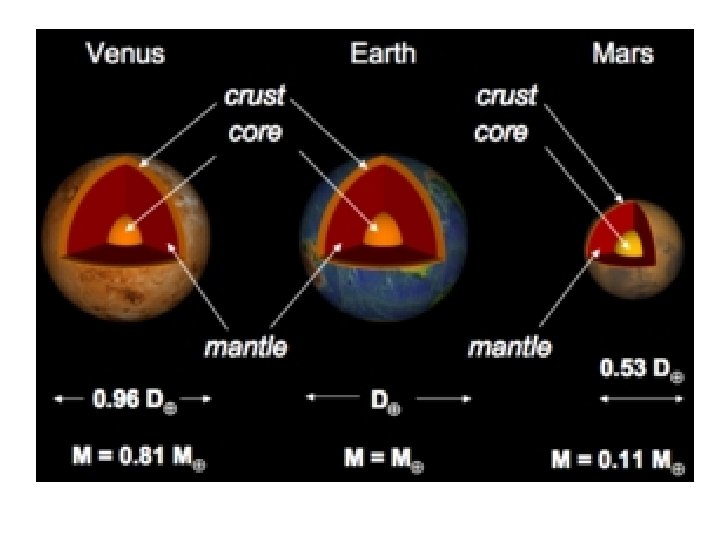
• Crust - the layer of rock that forms Earth’s outer surface. – Includes both dry land ocean floor – Thickness varies between about 5 -40 km – Thickest under high mountains and thinnest under the ocean
• Mantle - the layer of hot , solid material between Earth’s crust and core. – Very hot, but solid – Nearly 3000 km thick – Divided into 3 layers based on physical characteristic
Layers of the Mantle • Lithosphere - a rigid layer made up of the uppermost part of the mantle and the crust. About 100 km thick. • Asthenosphere - the soft layer of the mantle on which the lithosphere floats. • Mesosphere - beneath the asthenosphere, solid material extending to the Earth’s core.
Core • Made up of two parts. – The outer core is a layer of molten metal that is 2000 km thick. Scientist believe that the movement of the Earth’s metallic outer core is the source of Earth’s magnetic field. – The inner core is a dense ball of solid metal that is 2700 km thick with temperatures reaching 5000 degrees C.
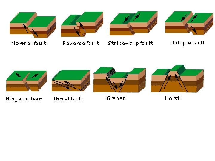
Fault A break or crack in the Earth’s lithosphere along which the rocks move.
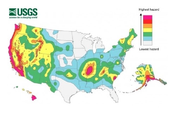
Earthquake The shaking that results from the movement of rock beneath Earth’s surface.
Seismic waves Vibrations that travel through Earth carrying the energy released during an earthquake.
Seismograph A device that records ground movements caused by seismic waves as they move through Earth.
The Richter Scale A very important fact in this scale is that as each number goes up, the earthquake increases *10 times* in power 1. Felt by instruments only 2. Felt by sensitive people and sensitive animals (10 times #1) 3. Felt by many people--feels like a passing truck (100 times #1) 4. Felt by everyone; pictures fall off the wall (1, 000 times #1) 5. Damage--may cause weak walls to crack and fall (10, 000 times #1) 6. A destructive earthquake in populated areas; falling smokestacks, etc. (100, 000 times #1) 7. A major earthquake causing serious damage (1, 000 times #1) 8. A disaster--a great earthquake that produces total destruction to nearby communities {1906 in San Francisco--8. 3} (10, 000 times #1) 9. Libson, Portugal had the highest ever in 1775 at 8. 9. (100, 000 times #1)
Tsunami A giant wave usually caused by an earthquake beneath the ocean floor.
The composition and properties of Earth’s interior are identified by the behavior of seismic waves. The refraction and reflection of seismic waves as they move through one type of material to another is used to differentiate the layers of Earth’s interior. Earth has an inner and outer core, an upper and lower mantle, and a crust.
Earth's Interior Geologist use direct evidence from rock samples and indirect evidence from seismic waves to learn about Earth’s interior. • http: //sunshine. chpc. utah. edu/Labs/Sei smic. Waves/
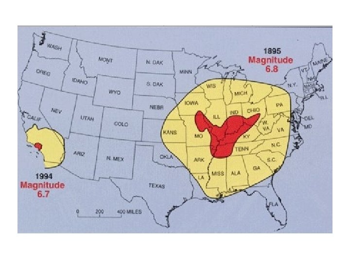
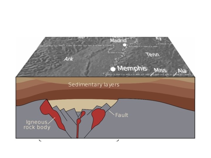
• The New Madrid Seismic Zone, sometimes called the New Madrid Fault Line, is a major seismic zone and a prolific source of intraplate earthquakes (earthquakes within a tectonic plate) in the southern and midwestern United States, stretching to the southwest from New Madrid, Missouri.
The faults responsible for the New Madrid Seismic Zone are embedded in a subsurface geological feature known as the Reelfoot Rift that formed during the breakup of the supercontinent Rodinia in the Neoproterozoic Era (about 750 million years ago). The resulting rift system failed to split the continent, but has remained as an aulacogen (a scar or zone of weakness) deep underground, and its ancient faults appear to have made the Earth's crust in the New Madrid area mechanically weaker than much of the rest of North America. This relative weakness is important, because it would allow the relatively small east-west compressive forces associated with the continuing continental drift of the North American plate to reactivate old faults around New Madrid, making the area unusually prone to earthquakes in spite of it being far from the nearest tectonic plate boundary.
Alluvial fans form where rapid loss of transport energy causes much of the stream’s sediment to be quickly deposited.
Deltas form where rapid loss of transport energy causes much of the stream’s sediment to be quickly deposited.
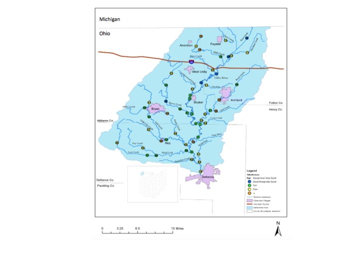
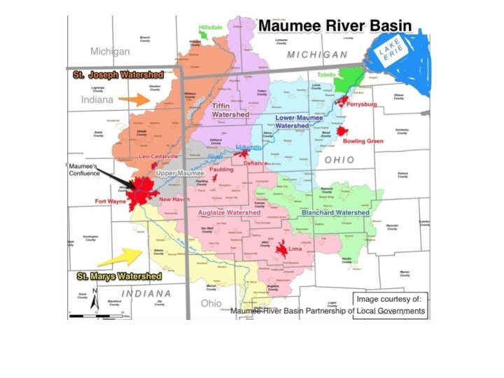
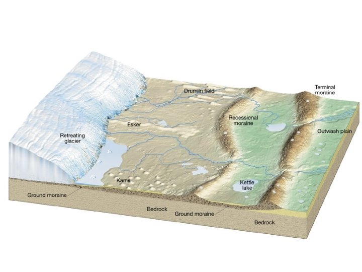
Factors that affect the patterns and features associated with streams and floodplains (e. g. , discharge rates, gradients, velocity, erosion, deposition), glaciers (e. g. , moraines, outwash, tills, erratic, kettles, eskers), …. .
A typical watershed; consisting of the stream channel, the adjoining banks, floodplain and valley slopes, the hydrologically connecting aquifer, and the surrounding drainage divide. Flow of water within the watershed is depicted by arrows.
Changes in stream channel geometry downstream within the stream system; (A) describes a decrease in gradient, and (B) describes a change in channel cross-sectional area.
A typical straight channel pattern formed on steep gradient streams.
A typical meandering channel pattern formed on a gentle gradient stream. Meander loops tend to migrate laterally and down-gradient within the valley (as indicated by the arrows and dashed lines), and eventually, adjacent loops may migrate into one another creating cut-offs.
A model of a meandering stream system’s floodplain and valley sedimentary fill.
A glacial erratic is a piece of rock that differs from the size and type of rock native to the area in which it rests. "Erratics" take their name from the Latin word errare, and are carried by glacial ice, often over distances of hundreds of kilometres. Erratics can range in size from pebbles to large boulders
One of the most common types of glacial lake is the kettle-hole or pot-hole lake, more properly known as an ice-block lake. These were formed by large chunks of ice that broke off form the main body of the glacier and were subsequently buried by gravel and mud. The insulating effect of the dirt cover probably prevented the melting of the ice block for many years, during which time the ground surface above was smoothed over some. When the ice block finally did melt, it left a water-filled depression roughly the same shape and size of the original ice block. This accounts for the rather uniform depth of many lakes of this type since the ice blocks were broken off the same glacial ice sheet. These lakes tend to have a narrow shoreline, steep sloping sides of the basin, and a rather extensive flat bottom.
Serpent Mound Crater