Plate Tectonics Earthquake Generation and Wave Behavior Do

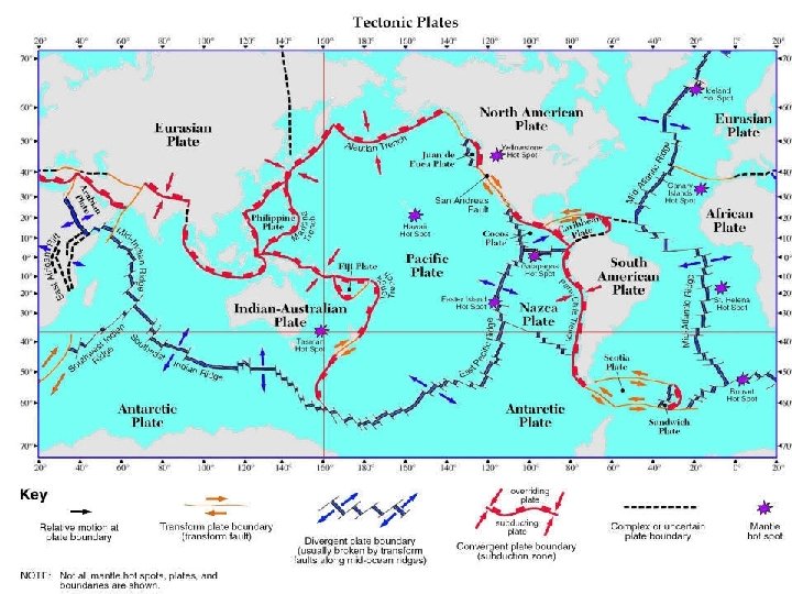
Plate Tectonics: Earthquake Generation and Wave Behavior Do Now: Explain why New York State is not prone to high earthquake activity. Use the map of the Earth’s tectonic plates to justify your answer

Destruction Earthquakes
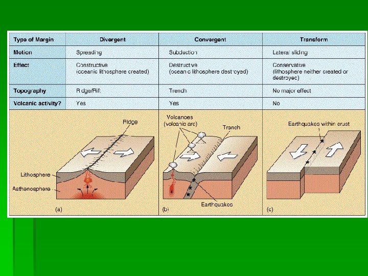
 As rigid plates")
What causes an earthquake? Elastic Rebound Video Link § 1. ) As rigid plates collide, diverge, or scrape past one another, stress builds in the crust § 2. ) Eventually the rock can no longer bend under such high stress, and breaks or “slips” along a fault § 3. ) The shock of this slip deep in the crust releases energy in the form of seismic waves

Recall Faults as being breaks in the rock

Focus Animation
 P-waves (Primary)- Arrive first & are compression or “push/pull”")
Seismic Waves § 1. ) P-waves (Primary)- Arrive first & are compression or “push/pull” waves. Travel the fastest & through S, L and G § 2. ) S-waves (Secondary)- Arrive next & are transverse, moving side to side like a wave in a rope and only through solid crust § 3. ) L-Waves- surface waves that occur once P & S wave have both arrived. MOST damaging

Seismic waves are recorded globally after an earthquake occurs Example: EQ AT NORTH POLE! *When seismic waves hit a substance with a higher density (core) they are refracted (BENT) which is why we get P-Wave SHADOW ZONES Seismic Waves and Refraction Video Link

Seismographs § seismic waves are detected with a sensitive instrument called a seismograph § A seismogram is the line recorded on the paper

§ Seismographs produce seismograms. These are the recordings of the seismic waves. #1 The higher the wavy lines on the seismogram—the stronger the earthquake is.

Reading a Seismogram #2 The closer the P & S waves arrive to one another, or the smaller the S-P interval is, the closer the station is to the epicenter!
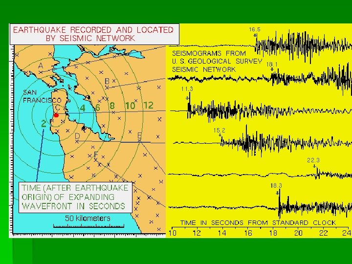

Which station is the difference between the P and S waves the least? What about the greatest?

Seismograph from Illinoi

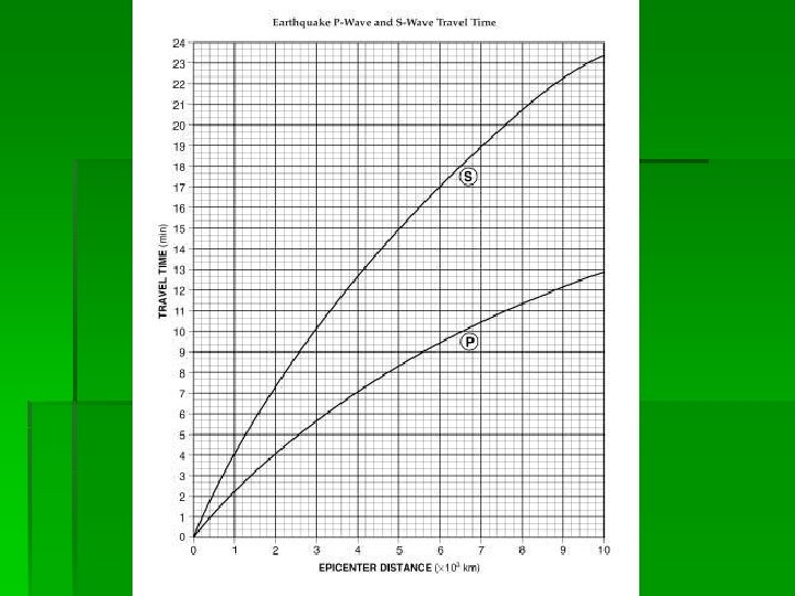
Finding The Distance to the Epicenter How does one find the distance to an epicenter? Click here for animation ESRT Interactive Chart

Origin Time P arrival t - P travel t= origin t* § Origin time means the actual time that the Earthquake occurred at the Epicenter You can find this by knowing: 1. ) What time the P waves first arrived at any station 2. ) Finding the travel time (how long it took PWaves to get there) 3. ) Distance to the Epicenter

In Perspective: A friend of yours who lives a half an hour away arrives at your house at 10: 45 a. m. Based on this, you know they must have left at 10: 15 a. m. § Real example: § An Earthquake was recorded at station A at 2: 25 p. m. You have the following information: The epicenter is 4000(km) away § 1. ) What is the travel time of the P-waves? ____ § Based on the travel time, what is the origin time of the EQ? _______
 Triangulation You need THREE (3)")
Locating an Earthquake Epicenter on a Map (AKA Triangulation) Triangulation You need THREE (3) seismic stations to do this § 1. ) Calculate difference in P and S wave arrival times § 2. ) Use same method to find Epicenter Distance § 3. ) Draw a circle around the seismic station with a radius equal to that distance
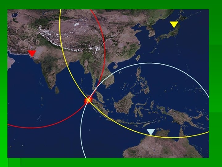

Where the 3 circles intersect denotes the location of the Epicenter

Triangulation in our class…

First find Distance to Epicenter using previous method

Step 2: Line up your compass using the scale on your map equal to the epicenter distance you found (make sure you start 0 at where the center of the circle is!!)

Write down in “cm’s” where the scale ends on your compass ruler= 3. 6 (cm)
 directly over the city whose epicenter distance")
Place the center of the circle (hole) directly over the city whose epicenter distance you found

Put your pencil in the closest dot to your measurement on the compass

Hold firmly the middle of your compass and drag the edge around to make your circle. This means that somewhere along the boundary of this circle, the epicenter is located

You must do three stations to find the Epicenter. Where they intersect, or form a triangle, is where the epicenter is located

Mercalli measures impact on humans from shaking

Richter measures actual amplitude of seismic waves and ↑ 10 x every number on the scale (1 -10)

Damage by Earthquakes § § Subsidence- sinking land Landslides Demolished Buildings and Roads Liquifaction- sediments + ground water become fluid § AND TSUNAMIS…. .
 in height! Tsunami Generation Animation")
Tsunami: 700 -800 km/hr & up to 20 (m) in height! Tsunami Generation Animation Link 1. ) Earthquake occurs under the ocean 2. ) Displaced crust “shoves” water upward , creating a massive wave
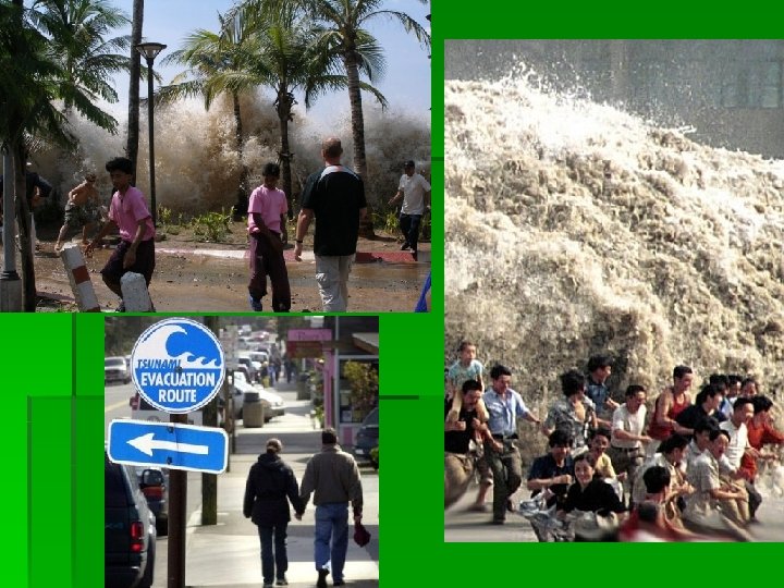

Right before a Tsunami hits the water recedes Japan

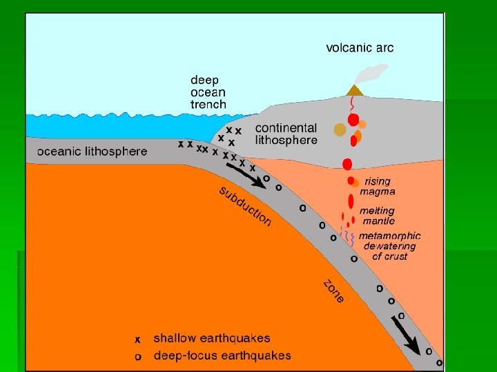
Do Now: Where would you expect Shallow Focus vs. Deep Focus Earthquakes to occur along plate boundaries? Where and WHAT types of boundaries?

Map: Chili earthquake foci depths Green: 0 -80 km Yellow: 81 -290 km Red: 291 -667
- Slides: 40