Plate Tectonics Continental Drift When you look at


- Slides: 46
Plate Tectonics
Continental Drift • When you look at a map of Earth’s surface you notice that the edges of some continents look as if they may fit together like a puzzle • In the 1800’s as Earth was being mapped accurately people began noticing this fact
Continental Drift • In 1912 Alfred Wegener proposed the idea of continental drift • Wegener believed that all land masses were connected as one land mass, and that they began breaking apart about 200 million years ago • He called this land mass Pangaea (pan JEE uh)
Continental Drift • During Wegener's lifetime there was not enough evidence to prove his theory of continental drift • Since his death in 1930 there has been many more forms of evidence to support his theory, lets look at the different types of evidence…….
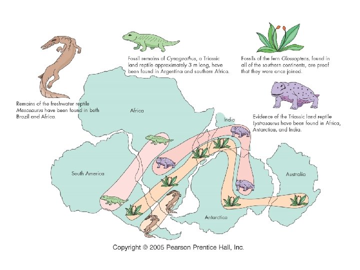
Fossil Clues • Fossils of the reptile Mesosaurus have been found in South America and Africa • Mesosaurus was a swimming reptile that lived in fresh water, it could not have swum from that far
Fossil Clues • Glossopteris is a tropical fern that lived about 250 million years ago • Fossils of Glossopteris have been found in Africa, Australia, India, South America, and Antarctica • The presence of this fern in some many areas with very different modern climates is also evidence of continental drift
Fossil Clues • Fossils of Cynognathus has been found in South America and Africa • Cynognathus was a land reptile and could not have swum that far
Fossil Clues • Fossils of Lystrosaurus have been found in Africa, Antarctica, and India • Lystrosaurus was also a land reptile and could not have swum that far nor lived in cold environments like Antarctica •
Climate Clues • Fossils of warmweather plants were found on the island of Spitzbergen in the Arctic Ocean • Wegener believed that Spitzbergen drifted from the tropics region
Climate Clues • Glacial deposits and grooved bedrock found in South America, Africa, India, and Australia indicate these continents were once covered with glaciers • This leads scientists to believe that these continents were once much closer to the South Pole at one time
Rock Clues • Similar rock structures are found on different continents • Parts of the Appalachian mountains are similar to those found in Greenland • South America and Western Africa have similar rock structures
How Could Continents Drift? • Although Wegener could provide some evidence to support his theory of continental drift, he could not explain how, when , or why these changes in the continents had taken place • Because these questions could not be answered at that time Wegener's theory was rejected
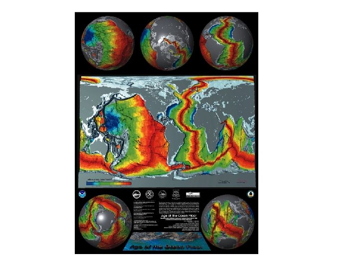
Seafloor Spreading • The invention of echosounding devices in the early 1950’s allowed scientists to construct accurate maps of the ocean floor • They discovered ridges and valleys extending through the Atlantic and in other oceans around the world
Seafloor Spreading • The theory of seafloor spreading states that hot, less dense magma in the mantle is forced up to the surface at mid- ocean ridges • It then turns and flows sideways , carrying the seafloor away from the ridge in both directions
Seafloor Spreading • As the seafloor spreads apart, magma located a few kilometers below the ridge moves upward and flows from the cracks • The magma solidifies and becomes new seafloor
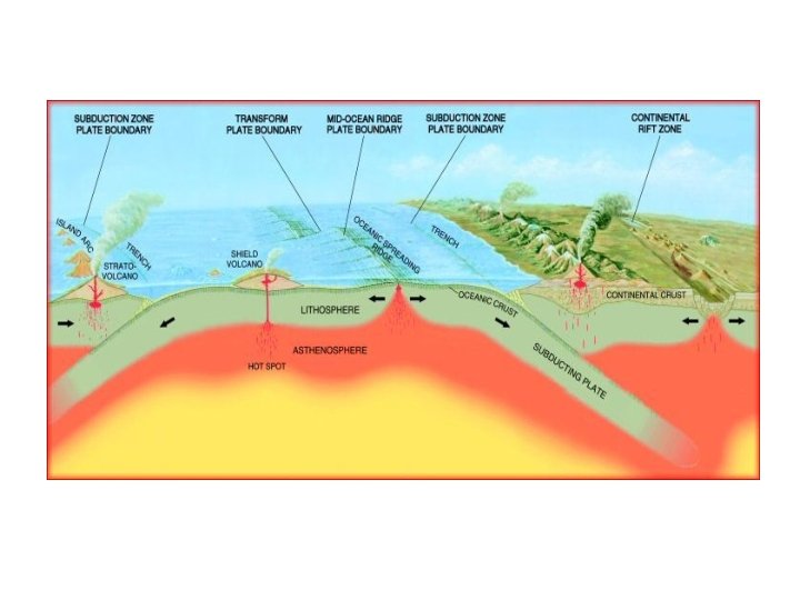
Seafloor Spreading • The seafloor that is carried away from the ridge cools, contracts and becomes more dense than the plastic like asthenosphere below it • Here the seafloor begins to sink downward forming trenches at subduction zones
Seafloor Spreading • Seafloor spreading is an example of a divergent plate boundary (where the plates move away from each other) • The Atlantic Ocean was created by this process • The mid-Atlantic Ridge is an area where new sea floor is being created
Seafloor Spreading • As the rift valley expands two continental plates have been constructed from the original one • The molten rock continues to push the crust apart creating new crust as it does.
Seafloor Spreading • As the rift valley expands, water collects forming a sea • The Mid-Atlantic Ridge is now 2, 000 meters above the adjacent sea floor, which is at a depth of about 6, 000 meters below sea level
Seafloor Spreading • The sea floor continues to spread and the plates get bigger and bigger • This process can be seen all over the world and produces about 17 square kilometers of new plate every year.
Age Evidence of Seafloor Spreading
Age Evidence • Scientist have bored into rock on the seafloor and obtained samples • They were surprised to find no rocks older than 180 million years (some continental rocks are over 4 billion years old
Age Evidence • Scientist also found that the youngest rocks were located at the mid-ocean ridges • The age of the rock became increasingly older farther from the ridges on both sides
Magnetic evidence of seafloor spreading • Scientist know that the Earth’s magnetic field has reversed itself several times in the past • Much of the ocean floor is made up of basalt which has iron in it, the iron aligns itself according to the magnetic field orientation at the time they are formed
Magnetic evidence of seafloor spreading • If Earth’s magnetic field is reversed, new iron minerals being formed would reflect that reversal • Scientists have found that rocks on the ocean floor showed many magnetic reversals • The magnetic alignment of the rocks reverse back and fourth in strips parallel to the mid-ocean ridge
Theory of Plate Tectonics • With the discovery of seafloor spreading, scientists began understanding what was happening to Earth’s crust and upper mantle • The idea of seafloor spreading showed that more than just continents were moving
Theory of Plate Tectonics • The theory of plate tectonics states that Earth’s crust and upper mantle are broken into sections • These sections called plates, move around on the mantle
Composition of Earth’s Plates • Plates are composed of • The plastic like layer the crust and upper below the lithosphere mantle, theses two is called the parts together are asthenosphere called the lithosphere • The less dense • This rigid layer is lithosphere floats and about 100 km thick move around on the and is less dense than denser asthenosphere material underneath
Plate Boundaries When plates move they can interact in three ways • They can pull apart (divergent) • They can move toward each other and collide (convergent) • They can move past each other (transform fault)
Divergent Boundaries • Boundary between two plates that are moving away from each other • Example: Mid-Atlantic ridge, this is where the North American plate is moving away from the Eurasian and the African plate
Divergent Boundaries • Another example of a divergent boundary is The Great Rift Valley in eastern Africa • Here a valley has formed where two continental plates are separating
Convergent Boundaries If new crust is being added at mid-ocean ridges why doesn't Earths crust keep getting thicker?
Convergent Boundaries • As new crust is added in one place, it disappears at another • The disappearance can occur when seafloor cools, becomes denser, and sinks, or where two plates collide at a convergent boundary
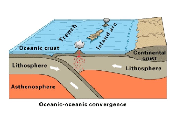
Convergent Boundaries There are three types of Convergent boundaries • Ocean-continent collision • Ocean-ocean collision • Continent-continent collision
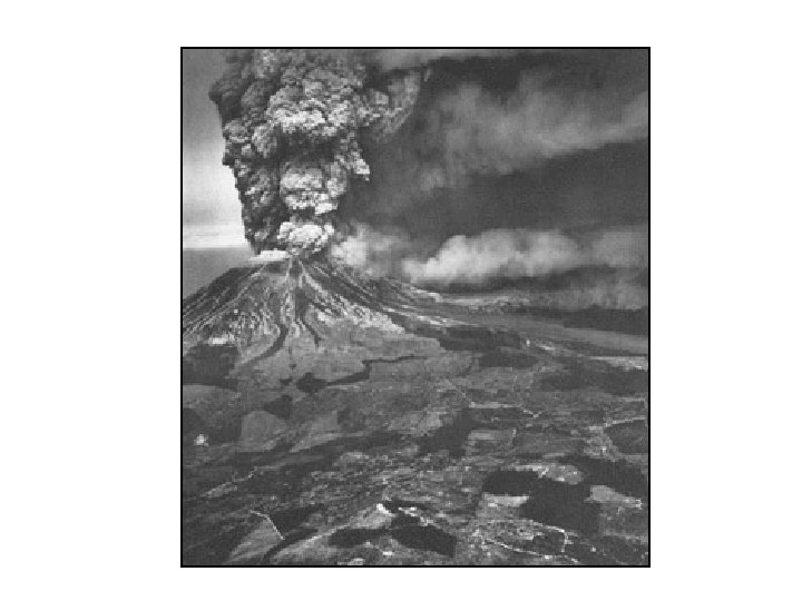
Ocean-Continent Collision • When an ocean floor plate collides with a less dense continental plate • The denser ocean plate sinks under the continental plate • The area where an oceanic plate descends into the upper mantle is called a subduction zone • High temperature and pressure cause the subducting plate to melt as it descends under the other plate • The newly formed magma is forced upward causing volcanoes along these boundaries
Ocean-Ocean Collisions • When two ocean plates • A deep-sea trench is collide, or when formed seafloor that has • New magma that is become denser due to formed rises up to cooling begins to sink form an Island arc of • One plate bends and volcanoes slides under the other, • Example would be the forming a subduction islands of Japan zone
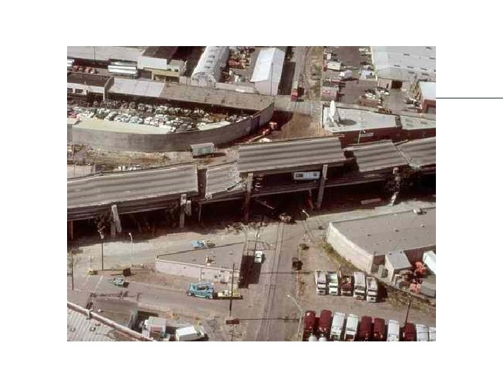
Transform Fault Boundaries • The third type of boundary occurs when two plates slide past one another • They may be moving in opposite directions or in the same direction at different rates • As one plate slides along another Earth quakes occur • Example: San Andreas fault
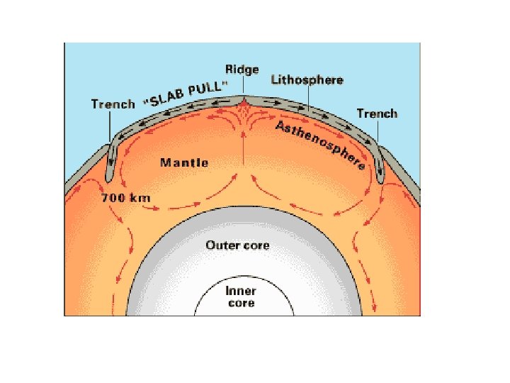
Causes of Plate Tectonics Convection Currents • Differences in density cause hot, plastic like rock in the asthenosphere to be forced to the surface • When it reaches the lithosphere it moves horizontally and friction between it and the lithosphere carries the lithosphere with it • As it cools it becomes denser and sinks into the mantle taking overly crust with it • These huge convection currents provide energy to move whole plates in the lithosphere
Continent-continent collision • Both plates are less dense than the asthenosphere • No subduction takes place • Two plates just collide and crumple up • Form mountain ranges • Earth quakes are common on these convergent boundaries • Example: Himalayan Mountains in Asia