Plate Tectonics Continental Drift Chapter 14 Section 1


: Newly formed hot")

 Plates Collide There is usually no")


- Slides: 37
Plate Tectonics - Continental Drift Chapter 14 Section 1 p. 392 -395
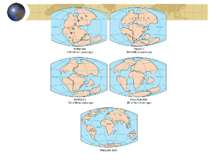
Continental Drift Hypothesis States that the continents have moved slowly to their current location
Continental Drift Hypothesis Proposed in 1912 by German meteorologist Alfred Wegener He thought that the puzzle-like fit of the continents wasn’t just a coincidence.
Continental Drift Hypothesis Wegener Suggested that all the continents were once connected as one large landmass now called Pangea means “all land” The land mass broke apart about 200 million years ago and The continents slowly drifted to their present positions
Evidence for Continental Drift Puzzle-like fit of the continents
Evidence for Continental Drift Similar fossils have been found on different continents Mesosaurus in South America and Africacouldn’t swim across ocean. Must have lived on both continents when they were joined. Labyrinthodont found in Southern Africa and in Australia Kannemeyerid found in North and South America and in Africa and Northern Asia
Evidence for Continental Drift Remains of warm-weather plants in arctic areas and glacial deposits in tropical areas suggest that continents have moved Fossil plant Glossopteris found in Africa, Australia, India, South America, and Antarctica. All of these regions must have been connected and had similar climates. Glacial deposits and rocks scoured and polished by glaciers found in South America, Africa, India, and Australia
Evidence for Continental Drift Similar rock structures are found on different continents Parts of Appalachian mountains of eastern US are similar to those found in Greenland western Europe. Rocks from Eastern South America are similar to those in western Africa
Continental Drift Hypothesis At first, continental Drift was not accepted because no one could explain how or why continents had moved. The idea was so radically different that people closed their minds to it. After Wegener’s death new technology helped find more clues, and new ideas related to continental drift were developed.
Plate Tectonics - Seafloor Spreading Chapter 14 Section 2 p. 396 -398
Seafloor Spreading Using sound waves, scientists discovered a system of underwater mountain ranges called mid-ocean ridges in many oceans. During World War I sound waves were used to detect submarines. During the 40’s and 50’s they were used to map the ocean floor. Sound waves echo off the ocean bottom- the longer the sound waves take to return to the ship, the deeper the water is.
Seafloor Spreading In the 1960’s Harry Hess suggested theory of seafloor spreading to explain the ridges.
Seafloor Spreading Hot dense material below the Earth’s crust rises upward to the surface at the mid-ocean ridges Then it flows sideways, carrying the seafloor away from the ridge. As the new seafloor spreads apart, magma moves up and flows from the cracks, cools, and forms new seafloor. Youngest rocks are located at the mid-ocean ridges and become increasingly older the further out you go.
Evidence for Seafloor Spreading In 1968 the research ship Glomar Challenger began gathering information about rocks on the ocean floor Using submersibles, new features and life forms were found near the ridges. They can survive here because molten material brings heat and chemicals to support the exotic life-forms found in deep ocean water.
Evidence for Seafloor Spreading Reversals of Earth’s magnetic field are recorded by rocks in strips parallel to ridges. Earth’s magnetic field has a north and a south pole. Scientists have determined that Earth’s magnetic field has reversed itself many times in the past. These changes are recorded in rocks that form along the ridges
Evidence for Seafloor Spreading Magnetic Time Scale Iron-bearing minerals will record the magnetic field direction when they form (just like a compass pointing north) Whenever the magnetic field reverses newly forming rocks will point the other way, but older rocks are already solidified and will not change. The magnetic alignment reverses back and forth in strips parallel to the ridges
Evidence for Seafloor Spreading The magnetic reversals showed that new rock was being formed at the ridges. This helped explain how the crust could move… Something continental drift could not do
Plate Tectonics - Theory of Plate Tectonics Chapter 14 Section 3 p. 400 - 409
Plate Tectonics In the 1960’s scientists developed a new theory that combined continental drift and seafloor spreading. It is called Theory of Plate Tectonics
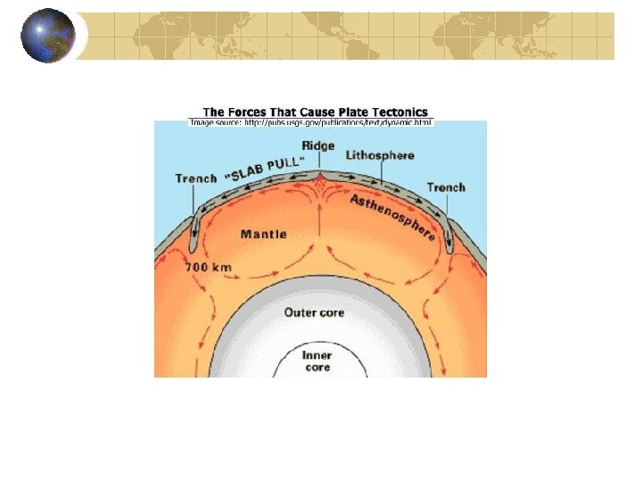
Plate Tectonics The Earth’s crust and upper mantle are broken into sections. The sections, called plates, move on a plasticlike layer of the mantle Geologists use the term Plastic to describe the consistency of rock that flows but is not a liquid like Silly Putty, modeling clay, or toothpaste.
Plate Tectonics The plates and upper mantle form the lithosphere The lithosphere is about 100 km thick and generally is less dense than the material underneath. The plastic-like layer is called the athenosphere The rigid plates of the lithosphere float and move around on the athenosphere
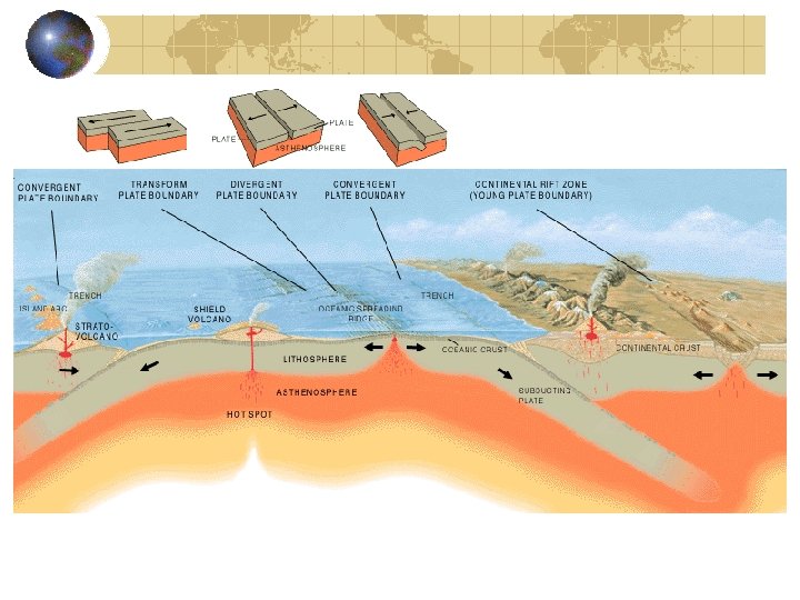
Plate boundaries When plates move, they can interact in several ways. They can collide into each other, or pull apart, or slide alongside each other When plates interact, the result of their movement can be seen at the plate boundaries
Plates moving apart. Divergent Boundaries Plates moving apart at the mid-ocean ridges are examples of divergent plate boundaries In the Atlantic ocean, the North American Plate is moving away from the Eurasian and the African plates. The Great Rift Valley in eastern Africa may become a divergent boundary. The continental plate is being pulled apart.
Plates moving togetherconvergent boundaries As new crust is added in one place, it disappears below the surface at another.
Plates moving togetherconvergent boundaries When Ocean and Land Plates meet: The denser oceanic plates sink under less dense continental plates The area where the ocean plate moves down is called a subduction zone This type of convergent boundary forms a deep sea trench
Plates moving togetherconvergent boundaries When Ocean and Land Plates meet (continued): Newly formed hot magma is forced upward along the subduction zones and forms volcanic mountains The Andes Mountain Range in South America contains many volcanoes that were formed at the convergent boundary of the Nazca and South American plates
Plates moving togetherconvergent boundaries When Two Oceanic Plates Collide The older, denser plate will subduct and sink down into the mantle. The Mariana Islands in the Western Pacific are a chain of volcanic islands formed from two oceanic plates colliding.
Plates moving togetherconvergent boundaries When Two Continental (Land) Plates Collide There is usually no subduction because both of these plates are less dense than the material of the athenosphere. Plates will crumple up to form mountain ranges. Earthquakes are common here, but not volcanoes. The Himalayas in Asia are forming where the Indo -Australian plate collides with the Eurasian Plate
Plates Sliding Past each other. Transform Boundary When one plate slips past another suddenly Earthquakes occur The Pacific Plate is sliding past the North American Plate forming the famous San Andreas Fault in California.
Causes of Plate Tectonics Convection inside the Earth Cycle of heating, rising, cooling and sinking is called a convection current. This process occurring inside the mantle of the earth is the driving force behind plate tectonics.
Features caused by Plate Tectonics The interaction of plates produces forces that build mountains, create ocean basins, and cause volcanoes. When rocks in the Earth’s crust break and move the energy is released as Seismic waves We feel this release as Earthquakes
Features caused by Plate Tectonics Faults and Rift Valleys – are formed at divergent boundaries where plates are pulled apart. Mountains and Volcanoes – are formed at convergent boundaries where plates collide. Strike-Slip faults- cause of Earthquakes are found at transform boundaries where plates grind past each other.
Testing for Plate Tectonics Using lasers and satellites, scientists can measure movements as little as 1 cm per year. Hawaii is moving toward Japan at a rate of about 8. 3 cm per year. Maryland(? ) is moving away from England at a rate of 1. 7 cm per year Scientists have observed that the plates move at rates from about 1 cm to 12 cm per year.