Plate Tectonic Movements Eric Angat teacher 1 What


- Slides: 37
Plate Tectonic Movements Eric Angat teacher
1. What is plate tectonics? Plate tectonics explains the formation of mountain ranges, volcanism, earthquakes and the movements in plate boundaries.
2. In what direction is North America moving? Asia Europe United Sates Atlantic ocean Pacific ocean Australia Africa South America
3. What are plate boundaries? Plates Boundaries are the locations where two tectonic plates interact, a boundary between these plates exist.
4. What is causing the tectonic plates to move? The convection currents in the mantle ( asthenosphere) result to movement of the tectonic plates.
5. What are three types of plate boundaries?
6. How is earth affected by transform boundaries? Transform boundaries result to earthquakes!
6. How is earth affected by transform boundaries? The New Madrid fault line Alabama, Arkansas, Illinois, Indiana, Kentucky, Mississippi, Missouri and Tennessee. Ramapo Faults spans N. J. , N. Y. and Pa. Charleston fault in South Carolina Transform faults results to earthquakes!
7. What are the different types of faults? San Andreas fault is 90% strike slip!
Strike-slip or Transform Boundary form the San Andreas fault is California and Charleston fault in South Carolina.
Here we have a landscape with a road, a fence, and a line of trees crossing a fault. As the crust moves, the rocks adjacent to the fault are deformed out of shape. Eventually the rocks are so stretched out of shape that they cannot bear the stress any longer. The fault slips, and the stage is set for the next cycle of strain buildup and release.
8. What is the difference between the Focus and epicenter?
F E Epicenter-The point on the Earth's surface located directly above the focus of an earthquake. Focus-The location where the earthquake begins ( underground).
9. What are three types of seismic waves? Seismic Waves Seismic waves come in several types as shown below: P-Waves Primary (they arrive first), Pressure, or Push-Pull. Material expands and contracts in volume and particles move back and forth in the path of the wave. P-waves are essentially sound waves and travel through solids, liquids or gases. S-Waves Secondary (arrive later), Shear, or Side-to-side. Material does not change volume but shears out of shape and snaps back. Particle motion is at right angles to the path of the wave. Since the material has to be able to "remember" its shape, Swaves travel only through solids. Surface Waves Several types, travel along the earth's surface or on layer boundaries in the earth. The slowest waves but the ones that do the damage in large earthquakes.
P-waves are the fastest and are essentially sound waves and travel through solids, liquids or gases.
S-Waves motion is at right angles to the path of the wave. Since the material has to be able to "remember" its shape, S-waves travel only through solids.
Surface waves are the slowest waves but the ones that do the most damage in large earthquakes.
Eastern North America Earthquakes 1534 -1994 Source: USGS Data
U. S. Earthquakes, 1973 -2002
Nuclear reactors of the world
10. How do we know the layers of earth?
Seismic Waves in Earth's Interior There are two ways to look at waves. One is to track ray paths, the path of any particular impulse. The other way is to track wave fronts, the boundary of the wave as it travels outward. A surfer riding a wave travels a ray path. The crest of the wave is the wave front. The animation below shows ray paths of a P-wave in the earth.
P wave detected on the other side of the planet. P wave travels across. Can travel in solids and liquids. S wave refracted, cannot travel in liquid. Earthquake Epicenter
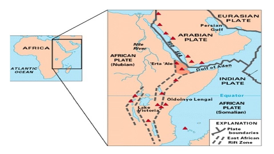
11. How is earth affected by divergent boundaries?
Sea Floor Spreading
A divergent boundary is causing sea floor spreading that creates new ocean floor resulting to a wider Atlantic ocean.
Divergent boundary forms a rift valley between East Africa and the main body of the African continent. The east coast of Africa is slowly breaking away from the main body of the continent at the rate of an inch per year as upwelling magma pushes up into the continental crust above, stretching it to the bursting point.
12. How is earth affected by convergent boundaries? form most Volcanoes Oceanic crust Continental crust causes subduction
Oceanic crust Continental crust volcano Oceanic crust Subduction mantle
Convergent Plate Boundary - Oceanic and Continental Plates
12. How is earth affected by convergent boundaries? Form mountain ranges like the Himalayas and Appalachian Continental crust
Convergent Plate Boundary - Continental
Mountain Ranges of the World
12. How is earth affected by convergent boundaries? form trenches like the Marianas trench. Oceanic crust Continental crust
Two oceanic plate converge
Some particularly dangerous faults in the US The New Madrid fault in the central United States is particularly dangerous. It is the most active seismic area east of the Rockies in the United States and runs from St. Louis to Memphis. The New Madrid fault line is best known for some of the most violent earthquakes to ever hit the United States: a series of four in 1811 and 1812. The quakes were estimated at magnitude 7. 5 to 8. 0, so strong the Mississippi River reportedly flowed backward. Damage occurred as far away as Washington, D. C. , and Charleston, S. C. There have been major earthquakes in the area about every 500 years in the past 1, 500 years. The earthquakes happened as a part of a sequence of events, not just one main shock. Seismologists say a similar catastrophe can happen thoughout the United States. The Ramapo Fault, a New York Metro-area fault line, runs 70 miles through New Jersey, New York and Pennsylvania. The fault has been quiet for about 200 years and it is sure that at some point an earthquake is going to occur. However, since the rules of the game are not well understood in this area, it is hard to forecast the hazard.