Physical Geography of SWANA Physical Features and Natural


 – 50 years apart On the left")


 of the sea was disrupted,")


- Slides: 30
Physical Geography of SWANA Physical Features and Natural Resources A Brief Introduction before Research
Where was this picture taken? In Turkey along the Mediterranean
Where was this picture taken? In Afghanistan along the Hindu Kush
Where was this picture taken? In Iran up in the Zagros Mountains
Where was this picture taken? A sandstorm in Saudi Arabia
Where was this picture taken? The Indus River Valley in Pakistan
Where was this picture taken? The Steppes of Kazakhstan
Where was this picture taken? In Israel along the Mediterranean
Where was this picture taken? Iraq
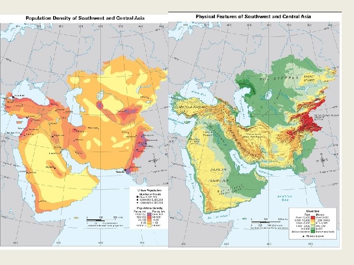
Overall – A Region of Extremes & Conflicts • Lowest spots on earth (Dead Sea) and highest spots on Earth (Hindu Kush Mts) • Traditional deserts (Rub al Khali) and rocky deserts lots of water (Gulfs, Seas, and Lakes) – but not all fresh • Fertile valleys near Tigris and Euphrates and salt flats of the Aral Sea (Cultural Hearth) • Hot days (115+ on average in summer) but cold nights (no moisture to hold in temp or cold winds) • Affected by altitudinal zonation and moderate climates near the temperate Mediterranean. • Two most important resources oil ( a lot) and water (not enough)
Overall – A Region of Extremes & Conflicts • Crossroads – Africa, Europe, and Asia meet. Cultures meet – can be good and/or bad. How? • Religion – majority Islamic, but also other monotheistic faiths – all of them have their historic roots here. • Population – majority under 25. What challenges might this create?
So how does this all effect the region? • Resources – are limited, resulting in competition and also cooperation • Cultural exchange, diffusion, and convergence – as well as conflict • A look at the one of the resources of the region – Oil.
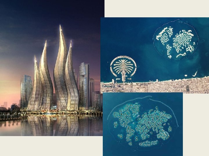
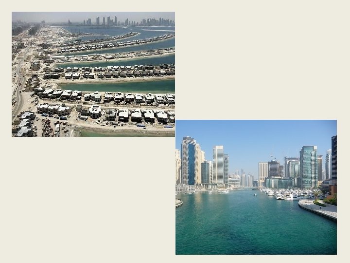
Two Views of Dubai (part of UAE) – 50 years apart On the left – a small fishing village with electricity just introduced. Nomads roamed outside the village. On the right - a modern city with one of the world’s largest human-made harbors. What effects of oil do you see?
Oil
Dubai’s oil wealth!
They even have a ski resort!!!!!
Some Intro Notes on Oil SW Asia has the largest known oil reserves – oil that has been discovered but remains unused over ½ of the world’s proven reserves. There also large reserves of natural gas – found just below the earth’s crust Money raised from the sale of oil and natural gas has been used to pave roads, construct modern buildings, and improve health care • Developed countries are largely dependent on oil and natural gas for energy and electricity needs, plastics, medicines, and other goods. • Some parts of SW Asia have become wealthy supplying this demand for oil and natural gas. • NONRENEWABLE RESOURCES
Water in SW Asia
What about water in SW Asia? • Technically, water is the most valuable resource in the region, but it doesn’t generate income like oil sales. • Mountainous areas have more water. Why? Which nations? • Water rich nations – Turkey, Iran, Afghanistan and use irrigation systems and even limited hydroelectic power and dams. What are the potential problems here? • What about nations that have limited access to water?
Solutions to the Lack of Water • Drip irrigation – small pipes that drip water just above the ground and directly above crops – water goes exactly where needed with less evaporation. • Desalinization – removal of salt from water. Incredibly expensive
Technology to the rescue – sort of… • Treated wastewater – can be used for drinking and agriculture, but requires advanced infrastructure. • Fossil Water – water pumped from underground aquifers that has been stored up over thousands of years. Not being replaced (too much pumping and too little rainfall)
• Water is the most challenging issue facing SW Asia today.
Aral Sea
The Aral Sea…a unique case study. • The Aral Sea has always received water from neighboring rivers. • In the 1950’s the Soviet Union began a policy of diverting the rivers into irrigation projects – mainly for growing cotton. • Runoff from chemicals and fertilizers entered the water system and found their way ultimately to the Aral Sea.
Effects on the Aral Sea • The balance (salt/fresh) of the sea was disrupted, it became severely polluted, literally ALL the fish died. • As the lake began to disappear from evaporation, a combination of salt and chemicals was left behind in a very windy region. This material was carried into neighboring towns.
Effects on neighboring populations • Some of the highest child mortality rates in the world. • Higher levels of throat cancer and respiratory disease • Climate change – without the water, summers became hotter and winters colder. Growing season shortened. • Death of the fishing industry
A few photos