Physical Geography of North America SSWG 1 Explain


 & Pacific Ocean (West) – Arctic Ocean (North)")


- Slides: 27
Physical Geography of North America SSWG 1 Explain why physical characteristics of place such as landforms, bodies of water, climate, and natural resources act as contributing factors to world settlement patterns. a. Identify and describe climates and locations of major physical features of North America. Explain how these physical characteristics impact settlement patterns including, but not limited to, the Mississippi River System, the Appalachian and Rocky Mountains, and the Canadian Shield h. Describe the spatial distribution of natural resources, including, but not limited to, fuel and energy, agricultural, and mineral sources. Predict how distribution of natural resources continues to impact global settlement patterns. .
Landforms & Resources
Vast Lands – Atlantic Ocean (East) & Pacific Ocean (West) – Arctic Ocean (North) & Gulf of Mexico (South) – 1/8 land surface of world Country Size (land area sq. km) Russia 16 million Canada 14 million United States 9 million
Abundant Resources – Fertile soils – Lots of water – Large deposits of minerals
The Eastern Lowlands – Flat, coastal plain along Atlantic Ocean & Gulf of Mexico – 3 subregions – Atlantic Coastal Plain – Gulf Coastal Plain – Piedmont
The Appalachian Highlands – Appalachian Mountains: extend 1, 600 miles from Newfoundland to Alabama – Oldest, soft peaks
The Interior Lowlands – Lowlands, rolling hills, lakes, rivers, fertile soil – 3 subregions – Interior Plains – Canadian Shield: flat, rock region covering nearly 2 million square miles & encircling Hudson Bay – Great Plains: vast, treeless grassland
The Western Mountains, Plateaus & Basins – Rocky Mountains: extends 3, 000 miles from Alaska south to New Mexico – Young, jagged peaks – Continental Divide: line of highest points in the Rockies marking the separation between rivers flowing eastward & westward – North America’s Highest Peak = Mt. Mc. Kinley – Pacific Mountain Ranges, Steep Cliffs, Deep Canyons, Lowland Desert Areas (Basins)
The Islands – Canada’s northernmost lands = icy islands near Arctic Circle – Greenland = Largest North American Island – Aleutian Islands – coastal Alaska – Hawaii – geographically not part of North America, but central Pacific – Politically, part of North America
Natural Resources
Resources Shape Ways of Life – Landforms of U. S. /Canada = variety & abundance of natural resources – Leading agricultural & industrial nations – Why?
Oceans & Waterways – 3 oceans = Atlantic, Pacific, Arctic – Gulf of Mexico (U. S. ) – Shipping & fishing Industries – Inland rivers, lakes – Transportation, hydroelectric power, irrigation, fresh water, fisheries – Great Lakes: Huron, Ontario, Michigan, Erie, Superior – Along with St. Lawrence Seaway world’s major shipping routes
Oceans & Waterways – Continent's longest & busiest river system is the Mississippi-Missouri-Ohio – Mackenzie River = Canada’s longest river – Flows across Northwest Territories to the Arctic Ocean
Land & Forests – Fertile soils – World’s leading food exporter – Agricultural land found in plains & river valleys – ½ Canada, 1/3 U. S. = forests & woodlands
Minerals & Fossil Fuels – Iron ore, nickel, copper, gold, uranium = Canadian Shield – Gold, silver, copper, uranium = Western Mountains – Coal, natural gas, oil, well-developed networks for transport of goods – U. S. is major importer of energy resources
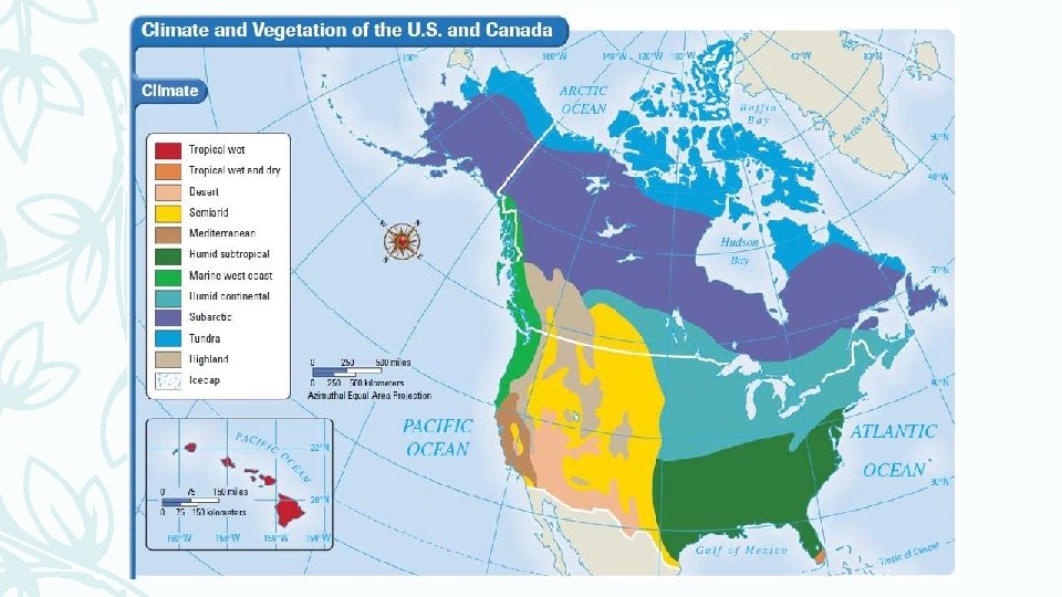
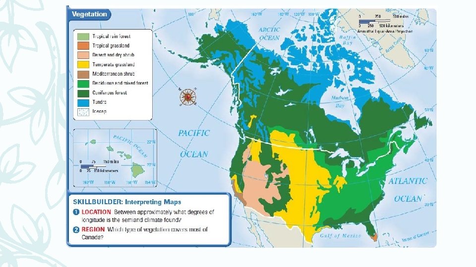
Climate & Vegetation
Shared Climate Zones – Northwestern Canada & Alaska = frigid winter temperatures – Canada/U. S. Border – U. S. has more climate zones = extends over larger north to south area – U. S. more mild = closer to mid-latitudes – Canada much colder = closer to high latitudes
Colder Climates – Arctic coast of Alaska/Canada = tundra – Long/bitterly cold winters & short/chilly summers – Huge, treeless plain – Rest of Canada – subarctic climate – Cold winters, short & mild summers – Vast forest of needle-leafed evergreens – Permafrost = permanently frozen ground
Colder Climates – Rocky Mountains & Pacific Ranges = highland climate & vegetation – Colder, little vegetation at higher altitudes – Mountains = rainy west side, dry east side
Moderate Climates – Humid Continental = north central, northeastern U. S. & southern Canada – Cold winters, warm summers – Good Climate & soil = agriculturally productive (dairy, grain, livestock) – Deciduous & needle-leaf evergreen trees – Forests east of Mississippi, template grasslands to the west – Marine West Coast = northern California to Southern Alaska – Moderately warm summers – Long, mild, rainy, foggy winters – Deciduous trees, evergreens, giant California redwoods
Milder Climates – Humid subtropical = southern U. S. – Hot, muggy summers – Mild & cool winters – Moist air from the Gulf of Mexico = rain during winter – Mild climate & adequate rainfall = agriculturally productive – Mediterranean Climate = central & southern coasts California – Dry, sunny & warm summers – Mild & somewhat rainy winters – Long growing season & irrigation = rich farming area for fruits & vegetables
Dry Climates – Semiarid Climate = Great Plains & dry northern parts of the Great Basin – Little rain = short grasses & Shrubs – Desert = southwest U. S. – Hot & Dry – Cacti, barren rock or sand – Ex: Mojave Desert
Tropical Climates – Tropical climates = Hawaii & southern Florida – Lush rain forests (Hawaii) – Wet & Dry seasons (Florida) – Always warm (no less than 70 degrees) – Tall grasses & scattered trees – Everglades: huge swampland