Physical Geography Landforms Overview Geologic Time Movements of


 is compressed")


")


 –")


 •")


 collide heat")

 • Formed from the cooling of molten")


 - sometimes so light it floats! Obsidian")
 • Visible crystals • Examples")


 Sandstone (larger grains) Shale (fine grains)")
")


- Slides: 56
Physical Geography: Landforms
Overview • • • Geologic Time Movements of the Continents Earth Materials Tectonic Forces Weathering and Erosion Processes Erosional Agents and Deposition
Geologic Time Pretend the age of the earth (4. 6+ billion years) is compressed into one calendar year. January 1 - Earth and planets formed Early March - liquid water stands in pools. Late March - earliest life July - oxygen is important part of atmosphere October 25 – multi-cellular organisms Late November - plants and animals abundant December 15 to 25 - dinosaurs arise and disappear 11: 20 pm, December 31 - Humans appear One second before midnight - Automobile invented
What is ‘tectonics’? • From Greek ‘tektonikus’ meaning building or construction • Plate tectonics refers to the process of earth crust formation, movement, and destruction.
What is a ‘Plate? ’ • Lithospheric plate: crust + upper mantle • Aesthenosphere: plastic mantle
History of Plate Tectonics • ‘Fit’ of coastlines recognized early – Sir Francis Bacon (1600 s) • No mechanism for motion
• 1915 Alfred Wegener proposes theory of continental drift. • Supercontinent Pangaea (‘all-earth’) [225 mya]. • Fragmentation and drift to current positions.
Plate Movement History
• Wegner’s evidence – Fit of continents – Fossil plants, animals, rock types / geology • match on opposite shores • deposits inconsistent with current geography
Striking Match of Geologic Regions
Striking Match of Biological Regions
History of Plate Tectonics • Problem with continental drift? – No sound mechanism for the ‘drift’! – Wegner hypothesizes spin of earth or tides…. .
History of Plate Tectonics • New theory for motion: Arthur Holmes (1930 s) – thermal convective cells in the upper mantle (aesthenosphere) – theory is largely ignored
History of Plate Tectonics • In the 1960 s, Harry Hess and Robert Deitz (geophysicists) propose sea floor spreading along mid-oceanic ridges for plate motion.
Sea Floor Spreading
Plate Tectonics Theory • Continental Drift + Sea Floor Spreading + new data Theory of Plate Tectonics
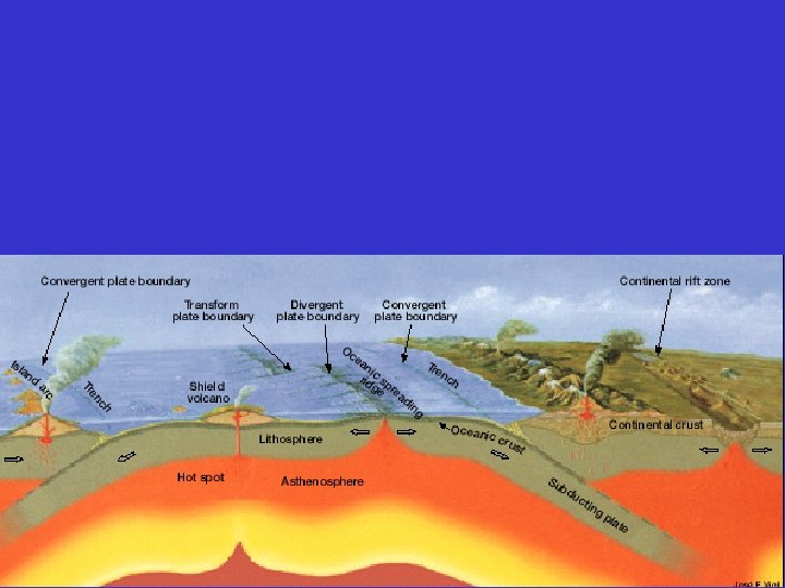
Plate Tectonics Theory • Plate boundaries: main location for Earth’s volcanic and earthquake activity. This is main place where mountains are created. • Type of plate boundary determines activity. • 3 types – diverging (spreading) – converging (colliding) – transform (sliding past each other)
Geography of the Plates • 7 major plates; several minor plates • Small plates / boundaries still unknown
Plate Margins: how do we know? • Marked by volcanic and tectonic activity
Convergent Plate Boundaries • Activity: – subduction; shallow to deep earthquakes; volcanism (continental) • Features: – ocean trench; explosive volcanic mtns on continental margin
Divergent Plate Boundaries • Landscape features: – land: rift valleys, volcanic mountains, thinning crust – ocean/sea: rift valleys, mountain ranges
Divergent Plate Boundaries • Examples: – Atlantic Mid-Oceanic Ridge – Red Sea – Rift valleys of eastern Africa
The Rock Cycle
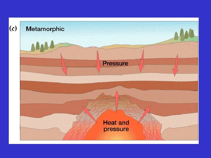
Earth Materials • Formation of Earth • Three major rock types – Igneous – Sedimentary – Metamorphic
Formation of the Earth’s Interior • @5 bya, plantesimals (meterorites, icy comets) collide heat released (Kinetic energy to thermal energy) • Entire planet melts (still cooling today) • Gravity sorts materials by density – Fe in center – Si and O compounds towards surface
The Earth’s Interior • General trends: temperature, density • Horizon composition, behavior Distance: 6730 km (3963 miles)
Igneous Rocks • Igneous (ignus = fire) • Formed from the cooling of molten rock (magma/lava), a process called crystallization. – Slow cooling larger crystals > dense rock – Rapid cooling small crystals > lighter rock
• Two classes of igneous rocks – intrusive: formed inside the Earth – extrusive: formed at Earth’s surface
Igneous Extrusive Landscapes Volcanic Crater and Cinder Cone: Indonesia Volcanic cones, obsidian flow: Mono Craters, CA Volcanic neck and dike: Shiprock, NM
Igneous Extrusive Rocks • Cools rapidly - exposed to surface • No visible crystals • Examples - rhyolite - andesite -basalt
Some unique volcanic rock types Pumice (vesicular) - sometimes so light it floats! Obsidian – glassy, ‘curved’ fracturing – used for arrowheads by Native Americans
Igneous Intrusive Rocks • Cools slowly (thousands of years) • Visible crystals • Examples - granite
Typical Igneous Intrusions
Exposed Batholiths Sierra Nevada, CA
Sedimentary Rocks
Sedimentary Rocks Relative Abundance by Type Compaction Cementing Formation
Limestone (Ca. CO 3) Sandstone (larger grains) Shale (fine grains)
Where do Sedimentary Rocks Form? Marine Terrestrial environments (non environments · Continental shelf -marine) · Rivers and floodplains (fluvial environment) · Lakes · Deserts (aeolian environment) · Continental slope and rise (deep sea fans) · Abyssal plain · Beach and barrier islands
Metamorphic Rocks or That’s very Gneiss, but I don’t give a Schist! Schist (narrow foliation) Gneiss (broad foliation)
Which Type?
Which Type? Sedimentary - limestone and shale
What type?
Metamorphic Amitsoq What type? Gneiss, Greenland, 3. 8 billion old
What type?
What type? Sedimentary - Sandstone in Utah
What type?
What type? Extrusive Igneous Reunion Island, Indian Ocean
What type?
What type? Folded Sedimentary ‘Sheep Fold’, Wyoming
What type?
What type? Sedimentary - Vasquez Rocks, Southern California
Morro Rock, CA What type?
Devil’s Tower, Wyoming Morro Rock, CA What type? Intrusive Igneous
The Rock Cycle