Physical Features of South America Part of the


")


- Slides: 15
Physical Features of South America
§Part of the Western Sierra Madre Mountains ranges, these mountains stretch from the southwestern United States to Honduras.
§In southeastern Mexico, Yucatan Peninsula separates the Caribbean Sea from the Gulf of Mexico-separates the region of Central America from the rest of North America.
§ A large arid-to-semiarid plateau Mexican Plateau that occupies much of northern and central Mexico; mostly covered by deserts and shrub lands, with pine-oak forests covering the surrounding mountain ranges and forming sky islands on some of the interior ranges.
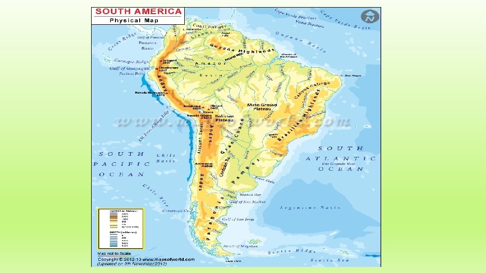
§The longest continental Andes Mountains mountain range in the world; form a continuous highland along the western edge of South America; extend from north to south through seven South American countries.
§Peninsula in Northwestern Baja Peninsula Mexico. It separates the Pacific Ocean from the Gulf of California; separated from mainland Mexico by the Gulf of California and the Colorado River.
§A grouping of the larger Greater Antilles islands in the Caribbean Sea; Cuba, Hispaniola (containing Haiti and the Dominican Republic), Puerto Rico, Jamaica, and the Cayman Islands.
§ Group of islands in the Caribbean Lesser Antilles Sea. Most form a long, partly volcanic island arc between the Greater Antilles to the north-west and the continent of South America. form the eastern boundary of the Caribbean Sea with the Atlantic Ocean.
§The largest river by Amazon River and Basin discharge volume of water in the world and, according to some, the longest in length; the basin is covered by the Amazon Rainforest.
§A plateau in South America, Atacama Desert covering a 1, 000 -kilometre (600 mi) strip of land on the Pacific coast, west of the Andes mountains. It is the driest non-polar desert in the world.
§ A sparsely populated region located Patagonia at the southern end of South America; comprises the southern section of the Andes mountains, the deserts, pampas and grasslands east of this southern portion of the Andes; two coasts: western facing the Pacific, eastern facing the Atlantic Ocean.
§ A sea of the Atlantic Ocean in Caribbean Sea the tropics of the Western Hemisphere; bounded by Mexico and Central America to the west and south west, to the north by the Greater Antilleshas the world's second biggest barrier reef.
§A marginal sea of the Pacific Gulf of California Ocean that separates the Baja California Peninsula from the Mexican mainland; thought to be one of the most diverse seas on the planet.
§Vast, fertile plains; Pampas South American lowlands, extending westward across central Argentina from the Atlantic coast to the Andean foothills.