Physical and Environmental Data Collection and analysis BISHOFTU

Physical and Environmental Data Collection and analysis BISHOFTU 2013 �. �

Part One : Physical Aspect Part Two: Environmental Aspect

PART ONE: PHYSICAL ASPECTS

Purpose: § To undertake various preliminary works so as to smoothen the consecutive tasks particularly the collection of data. Expected outputs: § Checklists, q questionnaire q Base maps, Topographic maps, etc. , q Summary results/information of the rapid appraisal, and, q Field work schedule

Task 1: Preparatory Work for Data Collection Activity 1: Decide what data types are required § At influence region/area, and § At urban level. Activity 2: Prepare(update) the necessary respective (regional/influence area as well as urban) data collection formats. § Questionnaires, § Checklists, and § Regional, Zonal and Wereda Political (Administrative) and Infrastructure Maps.

Task 2: Acquire Data and Relevant Ma. PS Activity 1: Prepare blueprint of the urban base map with appropriate scale (1: 5000 and/or 1: 2000) Activity 2: Purchase/Get Topographic Maps of 1: 50, 000 scale Activity 3: Get/purchase climatic data (if not available at hand)
")
Task 3: Conduct Background Assessment Activity 1: Review of previous urban plans (if any) Activity 2: Review secondary documents such as CSA Abstracts, atlases and others and collect information on the following: q. Geographical location and environmental characteristics; q. Population size; q. Current status of the town, etc. physical and

PHASE TWO- DATA COLLECTION AND COMPILATION Purpose q. To obtain information on physical characteristics, physical infrastructure services, expansion areas and other components. Expected outputs §Filled/answered questionnaires; §Minutes of meetings; §Sketch maps; and, §Compiled primary and secondary data

Task 1: Data Collection A. INFLUENCE AREA LEVEL Activity 1: Delineation of the influence region q. Conduct discussion with stakeholders, and q. Identify the influence region. Activity 2: Collect physical and environmental data of the influence region q. Get location map; q. Geographical setting of the influence region §Absolute geographical location, and §Relative geographical location. q. Natural resources [topography, drainage, climate, soil, mineral, vegetation and wildlife]

Activity 3: Collect influence region’s area, population and urban system data q. Area and population size; §Area (km 2), §Total area of cultivated land; and §Cultivable land, §Population size (total, urban and rural population), q. Regional urban system §Get map of regional urban settings and spatial distribution

Collect information on physical infrastructure elements of the study region Activity 4: q. Transport data §Get regional road map of appropriate scale, §road types and length, §Transport systems (road, air, rail and water), and traditional transport system. q. Communication systems data: §Telecommunication (fixed and mobile) service data, §Internet service data, and §Postal service data. q. Electric service data, and q. Water service data. .

Activity 5: Collect information on urban and rural-urban linkage q. Administrative service linkage data, q. Infrastructure linkage data, and q. Municipal service linkage information

B. URBAN LEVEL Activity 6: Collect information on physiographic features of the project town q. Get base map of the project town (1: 5000, 1: 2000) and Conduct field observation; q. Area and shape of the town; q. Location of the town; q. Topography; q. Altitude/elevation;

Drainage system; § Type and condition of surface water drainage basins /catchments/, § Efforts made to conserve the water resources from being contaminated by urban wastes and the utilization of land on the banks of rivers for compatible activities

Activity 7: Collect Climatic data of the project town q Temperature § Daily maximum, minimum and average, § Monthly maximum, minimum and average, and § Yearly maximum, minimum and average. q Rainfall § Mean monthly; § Mean annual; and, § Humidity. q Wind § Wind direction, and § Wind speed.

Activity 8: Collect data on physical infrastructure of the project town q. Road network and transport conditions; § Existing condition of road network in terms of accessibility and surface condition; § Condition of pedestrian walkway and bikeway; § Types of means of transport in the town; and § Existing condition of bus station (if there is bus station). q. Power supply; q. Telecommunication; and, q. Postal services.

Activity 9: Collect relevant information on natural and man-made constraints for future development of the project town q. Get base map of the town and Conduct field observation and identify and sketch §Natural constraints which are related to topography (like excessively high and/or low gradient) watercourses and gullies, geological hazards, etc. §Man made constraints (substation and high tension electricity cables, airport, military camps, quarry sites, etc. )

Activity 10: Collect relevant information on municipal/towns services q. General Market and Gulit/daily market/; q. Livestock Market; q. Abattoir; and, q. Religious centers and cemetery,

Task 2: Compile Collected Data Activity: Organize the collected data using appropriate methods q. Tally qualitative/quantitative information as required; q. Tabulate the statistical data; q. Present the data in the form tables; and, q. Organize appropriate maps/diagrams as required.
 §Key Questions §Have")
Tips to Phase 2: Data Collection Methods and Sources (TASK 1) §Key Questions §Have all the relevant (qualitative as well as quantitative) data been collected? §Have all key resources been obtained? §Are the key stakeholders consulted? §Collect Primary data through: §Interview; §Structured or other types of questionnaires; §Field observation, recording and sketching/mapping; §Reviewing existing Base Maps and Topographic maps; §Purchasing raw data from National Meteorological Agency; and, §Public and stakeholders discussion. §Collect secondary data through reviewing various documents from CSA, atlases, regional profiles, publications/reports of zonal and Wereda offices

PHASE THREE- DATA ANALYSIS AND INTERPRETATION Purpose of the Phase q. To give a realistic assessment of the situation at hand to draw critical problems and gaps to be addressed in the subsequent planning processes. Expected Outputs q. Final Report (analysis of current situations, trends, dynamics, opportunities, potentials, threats, strength, weaknesses and proposals) q. Slope and constraint map/maps

Activity 1: Analyze the organized physical and environmental data of the influence region q. Describe location and interpret the influence region with the help of appropriate maps; q. Analyze physical and natural resources such as topography, drainage, climate, water, soil, mineral, vegetation and wild life; and q. Potential/opportunity and risks for development.

Activity 2: Analyze the area, population distribution and density of the study region q. Calculate/measure the area of the study region; q. Evaluate population distribution and density of the influence region; q. Compare and contrast the influence region with zonal, regional, etc, levels and contrast among Woredas within the study region Identify potentials and threats for development.

Tips to Activity 3: Calculate crude population density, agricultural density and physiological using the following formula q. Crude population density = Total population Total area (km 2) q. Agricultural density = Rural population Cultivated land (km 2) q. Physiological density = Total population Cultivable land (km 2)

Activity 3: Analyze the regional urban system q. Evaluate level of urbanization of the influence region, q. Calculate urbanization rate and compare with the national and regional, and zonal levels, q. Compare and contrast level of urbanization at woreda level within the influence region q. Assess the distribution pattern and hierarchy of urban settlement, q. Identify peculiar characteristics
")
Tips to Activity 3: q. To determine level of urbanization employ (usually study region) Level of urbanization= Total Urban Population Total Population

Activity 4: Analyze physical infrastructure of the study region q. Assess the transport system (road, rail, air, water and traditional) ; q. Road length, network distribution and density; q. Identify areas that need intervention in terms of road; q. Describe the availability of telephone (fixed and mobile), postal, and electric services in the study region; and q. Identify potentials and threats for development.

Activity 5: Analyze administrative and infrastructure linkage with the project town q. Urban-Urban linkages q. Urban-Rural linkages §Administrative linkage, §Infrastructure, §Municipal service linkage, and §Identify threats and constraints. Activity 6: Analyze the urban specific location and topographic data q. Describe location and area, q. Analyze shape, topography and slope of the town, and, q. Identify critical problems.
 Length- Breadth ratio (L-B) ratio is expressed as:")
Tips to Activity 6: SHAPE a) Length- Breadth ratio (L-B) ratio is expressed as: Length of long axis of an area (A-B) Length of short axis of an area (C-D)
 Compaction Index (C. I): - is a more refined measure of")
Tips (Continued b) Compaction Index (C. I): - is a more refined measure of compactness and is defined as: Area of the cell (an area) being measured Area of the smallest inscribing circle ü Results approaching a unit (one) indicate more compact shape and vice versa. ü Identify problems of interaction and infrastructure provision that arise due to elongated (linear) shape.
 Slope Analysis q q § § Use GIS techniques( if available) If")
Tips (Continued) Slope Analysis q q § § Use GIS techniques( if available) If you work manually, follow the following procedures Get base map with contour lines, Classify & delineate contour lines with similar spacing, Measure horizontal distance (H. E) using scale ruler, Identify vertical interval (V. I), and employ: Slope = V. I x 100 (in %) Horizontal equivalent (or x 60 in terms of degree)
 q. Classify the slopes and produce a slope map with appropriate shading")
Tips (Continued) q. Classify the slopes and produce a slope map with appropriate shading or standardized color (0 -1%, 1 -5%, 5 -10%, 10 -15%, 1520% and > 20%) q. Calculate area of each slope class and recognize (identify) the total area that could be potentially suitable for urban development. q. Identify areas subjected to flooding and water stagnation (<2%) q. Identify areas with excessive slope for urban development activities (> 20%).

Activity 7: Analyze climatic situation of the town q. Calculate mean monthly, mean annual, etc temperature of the town, q. Identify extreme low and high temperatures, q. Calculate mean monthly and annual rainfall, q. Identify the prevailing wind directions and indicate wind speed, q. Identify critical climatic problems for urban planning.

Tips to Activity 7: Temperature Analysis q. Get 10 years climatic data from National Meteorological Agency, then (if not available use at least 5 years data). q. Calculate mean daily, monthly and annual temperatures and present using tables and graphs
 Mean daily temperature = max. Daily temp. + Min.")
Tips to Activity 7: (Continued) Mean daily temperature = max. Daily temp. + Min. daily temp. Two §Mean monthly temp. = Sum of mean daily temperature for the month Number of days in the month §Mean annual temperature = sum of mean monthly temperature for one year Twelve §Identify extreme low and high temperatures & impacts
 Rainfall Analysis q. Calculate daily mean, mean monthly, q. Calculate annual rainfall,")
Tips (Continued) Rainfall Analysis q. Calculate daily mean, mean monthly, q. Calculate annual rainfall, mean annual rainfall and present using tables and graphs § Mean annual rainfall = sum of ten or more years yearly rainfall Number of years

Tips to Wind Direction/Speed Analysis N. B. § prevailing wind directions help to determine the location of pollutant industries, waste disposal sites, abattoir, runway orientation, etc § wind speed help to decide whether wind break (shelterbelt) is needed and/or unwanted winds to increase outdoor human comfort.

Activity 8: Analyze major natural and man-made constraints for urban development

Activity 9: Analyze the organized data on physical infrastructure of the town q. Existing road network in terms of access & suitability, and identify major gaps, q. Describe the condition of pedestrian walkway, bikeway, motor way, etc. , q. Means of transport in the town and major problems, q. Traffic congestion and degree of car accidents, q. Parking spaces and identify gaps between demand existing conditions, q. Condition of bus station and identify gaps between the existing and required services, q. Problems and gaps between the existing and the required power, telephone and postal service
 Factors to be considered")
Tips for Bus Station Site Selection (in Activity 9 ) Factors to be considered in bus station site selection are: q. Accessibility: - bus station should be accessible by major and/or arterial road. q. Compatibility: - considering intensity of vehicular traffic, it should be far from noise sensitive areas such as school, hospitals, libraries, etc. q. Topography: - it is preferable if the slope the site is 5% or lower. q. Availability of infrastructure and other facilities telephone, electric power, pipe water line , etc) q. Area: - depends on the number and types of vehicles to be served

q. The selection and level of bus station depends up on §The number of vehicles that park at peak hours within a day; §The importance of the urban center (commercial, administrative, etc); and, §The extent of connection with important urban centers.

Activity 10: Analyze the organized data on municipal services of the town: q. Conduct field observation, q. Analyze existing condition of the general market and livestock market, and identify the gaps, q. Assess the existing situation of abattoir and identify gaps between the existing and required services, and q. Assess the condition of religious centers, cemeteries and identify key problems.
 q. Factors to be considered in the")
Tips for General Market (in Activity 10) q. Factors to be considered in the selection general market site are: §Centrality; §Accessibility; §Compatibility; §Topography: - slope less than 5% is more appropriate §Area: - determined by the maximum number of market attendees of peak hour/season, availability of enough space

Tip to select sites for livestock market q. Factors that should be considered for the selection of sites for livestock market-: §Peripheral location; §Accessibility; §Compatibility; üIt should be outside the central part of the town/city in order to reduce traffic congestion. ü If possible it should be near abattoir (for large cities only). üDominant flow direction of livestock. q Area- depends on the type (cattle, sheep, etc) and number of livestock.

Tip for Abattoir site selection q. Factors to be considered in the selection of sites for abattoirs: §It should be located in the periphery of a town/city; §It should not be located close to residential houses, schools, churches, public offices, etc; §It should be accessible at least with a compacted gravel collector road; §It should be located at least 5 km away from airport and runways (in the direction of approach and take off); §It should not be located in the direction of urban future expansion area; §Preferable slope is about 5%; §There should be adequate infrastructure services such as water supply, electricity, etc;
 Factors to be considered in the construction of abattoir §It should not")
Tips (Continued) Factors to be considered in the construction of abattoir §It should not be near latrines or any other waste disposal system; §It should not be near a factory from which smoke or dust can contaminate the meat; §It should have adequate area to accommodate the whole operational facilities required. §It should be at least 2 km away from sources of water supply (e. g. deep wells, ponds, lakes, etc. ).
 Factors to be considered in cemetery")
Tips for Cemetery Site Selection (in Activity 11) Factors to be considered in cemetery site selection are: q. Compatibility: üIt should be far from recreation areas, health facilities, sport fields, schools, etc. üThere should be a buffer zone between cemeteries and other urban activities q. Accessibility: - The site should be accessible to collector or minor arterial roads. q. Topography: - It is preferable if the slope is below 10%. However, in towns/cities where there is a shortage of land, areas with more than 10% slope can be used. q. Area: the area required for cemetery during the planning period is determined by death rate, number of followers of major religions and the area required for a single burial (i. e. 2. 88 m 2).
 q. Other points: §Cemeteries should be outside central parts of a town/city;")
Tips (Continued) q. Other points: §Cemeteries should be outside central parts of a town/city; §Cemeteries should not be located in direction of future expansion areas; §If there is an opportunity, it is better to locate cemeteries within compounds of worship places.

Task 2: Proposals and Finalization Activity 1: Summarize the overall findings, Activity 2: Identify planning issues and propose planning solution, Activity 3: Discuss on the results with the planning team and the stakeholders, Activity 4: Update the study as per the agreed comments, and Activity 5: Finalize the report and arrange deliverables

Planning Issues Planning Proposals/solutions Natural and Man-made constraints, Urban Expansion and Controlled Area Delineation Topography (steep slope very Ø Propose appropriate buffer zone flat areas with poor efficiency for the natural & man made of drainage), water courses, constraints to avoid or minimize gullies, geological hazards, etc related problems & to have Substation, high tension lines, sustainable urban growth. airport, military camps, quarry Ø Relocate man made constraints sites as required, Ø Propose compatible land use types along constraints. Absence of boundary well Large land holdings defined Ø Formulate legislative framework that ensure the delineated urban promotion and controlled boundaries. Ø Propose appropriate land use regulation.

Planning Issues Planning Proposal/solutions Road Network and Transport Car accident Ø Ø Upgrading and maintenance of road Awareness creation Construction of Standard roads Improve traffic management Traffic Congestion Ø Ø Ø Appropriate urban land use planning Encourage public transport services Encourage traffic discipline Propose hierarchically well articulated urban roads Provide adequate parking space Locate activities related to transport at appropriate sites Absence, incompatibility and inadequate size (area) of bus and freight terminals. Ø Propose bus and freight terminals at appropriate locations with adequate size (standard size) Air Transport Location incompatibility Ø Ø Ø Relocate some land use activities around the air port Height regulation Delineate buffer zone with aviation technical criteria. Electric power supply High tension electric lines and sub-station Ø Indicate buffer zone and designate appropriate land use activities.

PART TWO: URBAN ENVIRONMENTAL ISSUES
 A. B. C. D. Topics to be discussed: Relationship between")
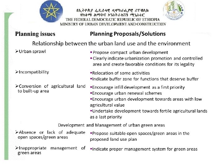
ENVIRONMENTAL ASSESSMENT (URBAN LEVEL) A. B. C. D. Topics to be discussed: Relationship between the urban land use and environment Development and Management of urban Green Area and open spaces Industrial development and the urban environment Waste management.

A. Relationship between the Urban land use and environment Data Types: §Relationship between land use (existing and future) and environmental protection; §Identify different land features and natural factors, and indicate their merits and demerits for urban development; §Identifying future expansion/ development area; §Identify activities and services that could threaten the environment; §Identify natural and man made constraints that guide (affect) different land use types.

Relationship between the Urban land use and environment Implications: §To recommend appropriate types of land uses; §To recommend appropriate housing and population densities; § To indicate appropriate zoning laws that ban urban development in specific areas of the city such as greenbelts and green ways, and open space; §To protect fragile lands/ ecologically sensitive areas; §To indicate impacts of squatter settlements on the environment; §To encourage improved land management in cities;

B. Urban Green Areas: Data Types: §Identify the location, size, type, character, ownership and management of open spaces/green areas; §Assess the accessibility and centrality of parks; §Current status and use of green areas/open spaces; §Cultural and aesthetic (Artistic) aspects.
: Implications: §To indicate appropriate green areas/open spaces in the proposed")
Urban Green Areas (Continued): Implications: §To indicate appropriate green areas/open spaces in the proposed land use plan, to locate appropriate urban green areas/open spaces to create comfortable living environment; §To enhance citizens’ participation and enforce legislative and planning aspects in management and maintenance of open space and urban green development; §Respect cultural and aesthetical aspects when developing open space and urban green.

C. Industrial development and the urban environment Data Types: §Compatibility with adjacent land uses and vulnerable natural resources; §Type, volume and nature of waste generated by different Industries; § Factors for the siting of industries; §Waste management system of respective industries; §Type, nature and amount or volume of raw materials used; §Other major environmental and socioeconomic impacts associated with industrial development; etc.
 Implications: §To assist Industrial site selection/industrial zone;")
Industrial development and the urban environment (continued) Implications: §To assist Industrial site selection/industrial zone; §To examine the degree of industrial pollution and waste; §To suggest sustainable industrial development.
 Steps of industrial selection: §Prepare list of")
Industrial development and the urban environment (continued) Steps of industrial selection: §Prepare list of the factors considered important to the location of the individual plant. §Establish values for each factor. §Designate mandatory factors. §Evaluate all locations. §Assign points to each location factor. §Select the location. §Pollutant industries should be located against the prevailing wind; §Pollutant industries should not be proposed closer to residential quarters and health and educational service rendering institutions;
 Selection criteria for industrial sites: §Reasonably flat")
Industrial development and the urban environment (continued) Selection criteria for industrial sites: §Reasonably flat land (Not more than 5%); §Availability of utilities; §Accessibility; §Compatibility with the surrounding uses; and, § Consideration of prevailing winds.
: §Types and nature of solid waste generated;")
D. Waste management Data Types (Solid waste): §Types and nature of solid waste generated; §Major sources of solid waste; §Average per capita solid waste generation; §Methods of solid waste collection and transportation; §Number of solid waste storage facilities, their volume, and spatial distribution; §Employees engaged in solid waste management; §Available equipments for solid waste management; §Factors for solid waste disposal site; §Role of different actors (NGOs, informal sector, government); §Recycling and reusing mechanisms; §Budget allocated; §Inter-municipal cooperation.
 Data Types (Liquid waste): §Availability of toilet facilities by type; §Mechanisms")
Waste Management (continued) Data Types (Liquid waste): §Availability of toilet facilities by type; §Mechanisms of transportation, disposal recycling, and treatment of liquid waste; §Number of public toilets and their spatial distribution; §Budget allotted for waste management; §Inter-municipal cooperation; §Site selection.
 Implications (both solid and liquid wastes): §To conserve ecologically sensitive areas;")
Waste Management (continued) Implications (both solid and liquid wastes): §To conserve ecologically sensitive areas; § To Identify poor sanitation areas, improper waste disposal sites and their impacts & propose solutions; §To determine amount of solid waste generated and propose appropriate storage, collection, transportation and disposal mechanisms for the future planning period. §To develop alternative strategy for recycling of wastes; §To propose appropriate dumping sites or sanitary landfill sites; §To assess the existing condition of toilet facilities, and liquid waste disposal sites; §To initiate economic utilization of wastes; etc.
 Solid waste Management The four principal elements of any solid waste")
Waste Management (continued) Solid waste Management The four principal elements of any solid waste management system: §Storage; §Collection; §Transport; and, §Disposal. Compatibility between each of the three stages of storage, collection and transport is essential to ensure efficient operation.
")
Solid waste storage §Solid waste storage facilities may be classified as primary (or individual) and secondary (or communal) storage facilities. §As far as possible the storage facilities must be animal-proof, insect-proof, washable and robust (strong) enough to meet the exigencies (Requiremenets) of normal use.
 collection §Door-to-door collection")
Solid Waste-collection Methods §Communal collection §Block collection §Kerbside (entrance) collection §Door-to-door collection

Solid waste: disposal mechanisms §Sanitary landfill/open dump sites §Incinerators §Reusing/recycling mechanisms

Table : Selection criteria for solid waste disposal sites

- Slides: 71