PARTS OF A MAP Objective To describe and

PARTS OF A MAP Objective: To describe and identify the various parts of a map. 1. 2. 3. 4. For a drawing to be a map, it must have the following parts: Scale: The map is drawn to a given scale and this scale is used to measure distances on the map. Arrow showing Direction: If there is no arrow showing north, then the top of the map is north. Key or Legend: The Key or Legend tells us the meaning of the symbols used on the map. Title: The Title tells us what the map is

MAP SCALE Maps are pictures of the earth that are much smaller that the real life places they show. Since the objects are always larger, we must reduce their sizes when we put them on paper. This relationship between the size of the drawing and that of the life object is known as the scale. On each map, a measured distance will represent a fixed distance on the earth. This relationship is often expressed in one of three types of scales: Word scales Linear Scales and Representative Fractions

Word Scales uses words to show the relationship between map distances and real distances. A Linear Scale or Bar Scale uses a line or bar to show the relationship between map distances and real –life distances. An example of a word scale is 1 inch = 10 miles. An example of a linear scale is _________ A Representative Fraction does not show units of measurements, it is simply a fraction that shows the relationship between map distances and real life distances. An example of a representative fraction is 1: 2000. This example is read ‘ 1 is equal to 2000. ’ When you use scales, you must be aware that there are two systems used for measuring distances. These two systems are the British or Imperial System and the Metric System.

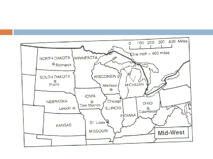
Classwork 1. 2. 3. 4. 5. How far is Columbus, Ohio, from Madison, Wisconsin, on the map? How far is this in real distance? Is St. Louis, Missouri, or Lincoln, Nebraska, closer to Chicago, Illinois? About how many miles is Lincoln, Nebraska, from Bismarck, North Dakota? About how many miles is Pierre, South Dakota, from Columbus, Ohio?

DIRECTION Objective: To describe the compass as an instrument for measuring direction. Direction must be indicated on a map or plan. It is shown by means of an arrow pointing to the North. In most maps, the North Point is placed within the map or in the key box where yon can find symbols. You can find where North is by using an instrument known as the compass.

FOUR CARDINAL POINTS The compass has four main points known as cardinal points. They are North, South, East and West. To give compass point direction on maps, we use the four cardinal points – east, west, north

EIGHT POINT COMPASS In the eight-point compass, the four main points are subdivided to form four new points. These new points are Northeast, Southeast, Northwest and Southwest. The names of the new points are taken from the cardinal points that fall between them.

SIXTEEN POINT COMPASS The sixteen-point compass includes all the previous directions plus eight other new ones. Again the name of the direction comes from the two directions on either side of it. These new eight points are North northeast, East southeast, South southeast, West southwest, West northwest and North northwest.

Classwork 1. 2. 3. 4. 5. 6. What is the direction of Port-of-Spain from Princes Town? The direction of rio Claro from Arima is Port Fortin is what directtion from Couva? What is the direction from Guayaguayare of Princes Town? Travelling from Port-of Spain” to Arima is traveling in what direction? If you want to go to Piarco from Rio Claro you have to travel in what direction?
- Slides: 10