PART 1 Basic Land Navigation Module 5 Terrain

PART 1 Basic Land Navigation Module 5 Terrain Relief PART 1 BASIC LAND NAVIGATION MODULE 5 • The Topographic Map – Information Terrain Relief

PART 1 Basic Land Navigation Module 5 Terrain Relief CONTOUR LINES – Knowledge of the relief of an area is extremely important to a wilderness navigator. • The most graphic technique ever devised to show relief information is the contour line. – If you were to walk a contour line you would never go down hill and never up hill, and eventually you would arrive back where you started.

PART 1 Basic Land Navigation Module 5 Terrain Relief CONTOUR LINES Contour Interval ~ The contour interval is the distance between each contour line. The contour interval is found along the bottom edge, center of the map. Intermediate Contour ~ a brown line on a topographic map and represents a line of equal elevation. Index Contour ~ a bolder/wider brown line that has the elevation value marked at various intervals as a part of the line. Example: contour is 20 feet interval A=700 ft B=740 ft C=770 ft D=820 ft

PART 1 Basic Land Navigation Module 6 Map Information – Identification What a Topo map and actual Land features show

Can you see it?

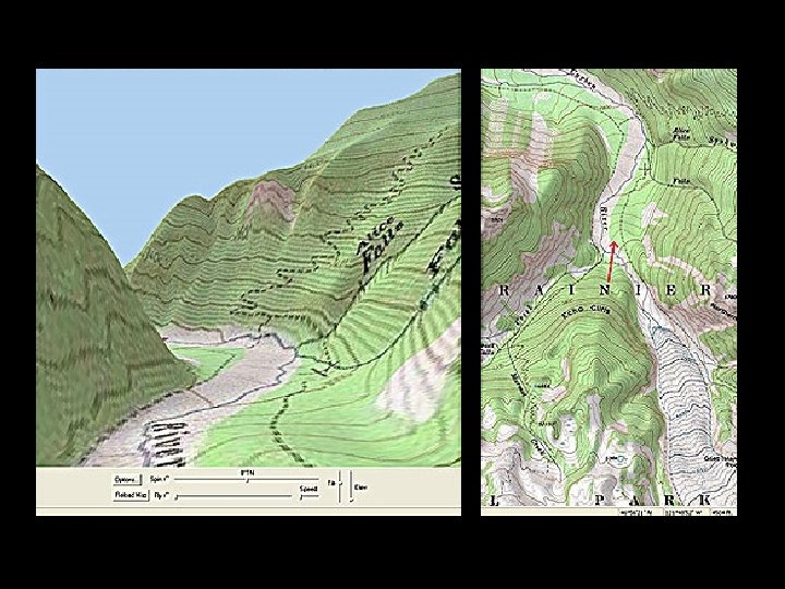
PART 1 Basic Land Navigation Module 5 Terrain Relief Terrain Features

PART 1 Basic Land Navigation Module 5 Terrain Relief RIDGE

Some Typical Terrain Features

PART 1 Basic Land Navigation Module 5 Terrain Relief HILL

PART 1 Basic Land Navigation Module 5 Terrain Relief S A D D L E a. A saddle-shaped depression in the ridge of a hill.

PART 1 Basic Land Navigation Module 5 Terrain Relief VALLEY

PART 1 Basic Land Navigation Module 5 Terrain Relief DEPRESSION

PART 1 Basic Land Navigation Module 5 Terrain Relief CLIFF or ESCARPMENT

PART 1 Basic Land Navigation Module 5 Terrain Relief Terrain Features
- Slides: 15