
Overview of the Spacebased Weather and Climate Extremes
Overview of the Space-based Weather and Climate Extremes Monitoring (SEMDP) Demonstration Project (SEMDP) Toshiyuki Kurino WMO OBS/Space Programme

Background SEMDP Workshop, 19 -22 March 2018, BMKG HQs, Jakarta, Indonesia
The Workshop on Operational Space-based Weather and Climate Extremes Monitoring (SWCEM) was held in Geneva, Switzerland on 15 -17 February, 2017. The Workshop provided for a dialogue amongst satellite operators, WMO Regional Climate Centres (RCCs), National Meteorological and Hydrological Services (NMHSs), and the science community to stimulate the utilization of space-based observation data and products for monitoring selected weather and climate extremes (heavy rainfall and drought in particular) on a routine basis (“in operations”), in response to current and future user requirements. SEMDP Workshop, 19 -22 March 2018, BMKG HQs, Jakarta, Indonesia
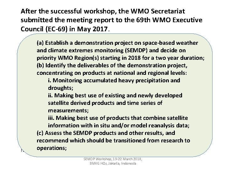
After the successful workshop, the WMO Secretariat submitted the meeting report to the 69 th WMO Executive Council (EC-69) in May 2017. Establish a demonstration project on space-based weather - EC-69(a) decides to support a demonstration project on space-based and climate extremes monitoring (SEMDP) and decide on weather and climate extremes monitoring (SEMDP) in WMO Regions to priority WMO Region(s) starting in 2018 for a two year duration; the extent that resources are available; (b) Identify the deliverables of the demonstration project, on products at national and regional levels: - EC-69 concentrating requests: i. Monitoring accumulated heavy precipitation and (1) The presidents of the Commission for Climatology (CCl) and the droughts; Commission for Basic Systems (CBS), with the support of the other TCs ii. Making best use of existing and newly developed and RAs, to: (a) …. . satellite derived products and time series of (b) …. . measurements; (c) …. . iii. Making best use of products that combine satellite information with in situ and/or model reanalysis data; (c) Assess the SEMDP products and other results, and (2) The Secretary-General to provide the necessary assistance and recommend which should be transitioned from research to mobilize resources for the establishment of a pilot SEMDP in WMO operations; Regions. SEMDP Workshop, 19 -22 March 2018, BMKG HQs, Jakarta, Indonesia
- NOAA/NESDIS to support the Space-based Monitoring of Weather and Climate Extremes project by providing satellite observations of heavy precipitation events, WMO Secretariat requested the Coordination Group for Meteorological and land surface parameters for monitoring droughts. The observations are Satellites (CGMS), in its 45 th meeting in June 2017 to support the SEMDP required with a short latency of about one day. Furthermore the project requires the creation of climate reference data sets which will be used by the RCCs to implementation with placing actions on CGMS members, the IPWG and classify observations as extreme event or not. the joint CEOS-CGMS WG Climate. The following actions were agreed. - JAXA to support the Space-based Monitoring of Weather and Climate Extremes project by providing a short term (from 5 -day up to monthly) climate normal from GSMa. P data archives as a reference precipitation data set for the initial SEMDP areas, i. e. East Asia and Western Pacific regions. JAXA is also requested to set-up the on-line environment to provide GSMa. P data with short latency to be utilized in the SEMDP. - IPWG co-chairs and rapporteur to provide guidance on the estimation of uncertainties and representativeness of the short-latency precipitation products related to the Space-based Monitoring of Weather and Climate Extremes project. - CEOS/CGMS Working Group on Climate to provide feedback on the proposed definition for ICDR. SEMDP Workshop, 19 -22 March 2018, BMKG HQs, Jakarta, Indonesia
The ad-hoc meeting for drafting the Space-based Weather and Climate Extremes Monitoring (SWCEM) Demonstration Project (SEMDP) Implementation Plan was held in Geneva, Switzerland on 25 -29 September, 2017 as a follow up to the kick-off workshop on SWCEM that took place in February 2017. - The meeting focused on drafting an implementation plan for the project that will begin in 2018 with a duration of two years. - The pilot study will focus on WMO regions II and V (East Asia and Western Pacific regions) and will infuse satellite data sets into routine use by WMO Regional Climate Centers (RCC), and develop a value-added products for distribution and use by WMO National Meteorological and Hydrological Services (NMHSs). SEMDP Workshop, 19 -22 March 2018, BMKG HQs, Jakarta, Indonesia
Introduction to SEMDP Workshop, 19 -22 March 2018, BMKG HQs, Jakarta, Indonesia
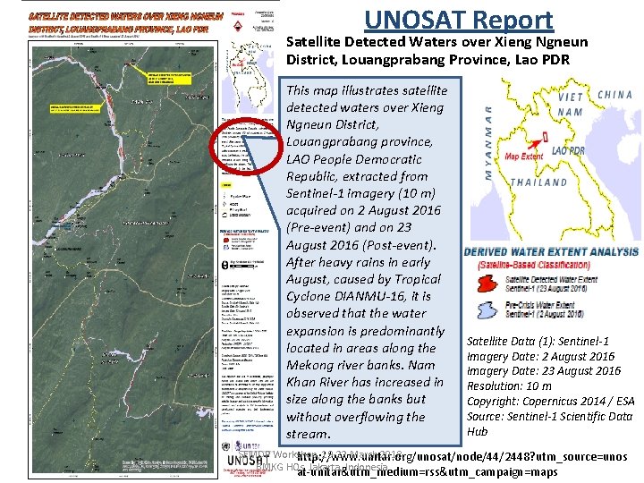
UNOSAT Report Satellite Detected Waters over Xieng Ngneun District, Louangprabang Province, Lao PDR This map illustrates satellite detected waters over Xieng Ngneun District, Louangprabang province, LAO People Democratic Republic, extracted from Sentinel-1 imagery (10 m) acquired on 2 August 2016 (Pre-event) and on 23 August 2016 (Post-event). After heavy rains in early August, caused by Tropical Cyclone DIANMU-16, it is observed that the water expansion is predominantly located in areas along the Mekong river banks. Nam Khan River has increased in size along the banks but without overflowing the stream. Satellite Data (1): Sentinel-1 Imagery Date: 2 August 2016 Imagery Date: 23 August 2016 Resolution: 10 m Copyright: Copernicus 2014 / ESA Source: Sentinel-1 Scientific Data Hub SEMDP Workshop, 19 -22 March 2018, http: //www. unitar. org/unosat/node/44/2448? utm_source=unos BMKG HQs, Jakarta, Indonesia at-unitar&utm_medium=rss&utm_campaign=maps
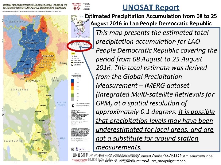
UNOSAT Report Estimated Precipitation Accumulation from 08 to 25 August 2016 in Lao People Democratic Republic This map presents the estimated total precipitation accumulation for LAO People Democratic Republic covering the period from 08 August to 25 August 2016. This total estimate was derived from the Global Precipitation Measurement – IMERG dataset (Integrated Multi-satellite Retrievals for GPM) at a spatial resolution of approximately 0. 1 degrees. It is possible that precipitation levels may have been underestimated for local areas, and are not a substitute for ground station measurements. SEMDP Workshop, 19 -22 March 2018, http: //www. unitar. org/unosat/node/44/2447? utm_source=unos BMKG HQs, Jakarta, Indonesia at-unitar&utm_medium=rss&utm_campaign=maps

An Example of Climate Monitoring by RCC http: //ds. data. jma. go. jp/tcc/products/climate/climatview/frame. php SEMDP Workshop, 19 -22 March 2018, BMKG HQs, Jakarta, Indonesia
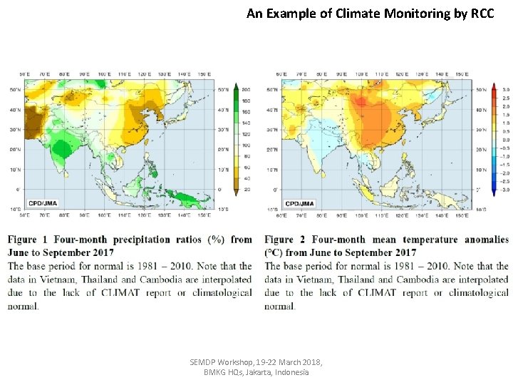
An Example of Climate Monitoring by RCC SEMDP Workshop, 19 -22 March 2018, BMKG HQs, Jakarta, Indonesia

Monthly Mean Precipitation (mm) in April – CLIMAT (30 -year mean) vs GSMa. P (17 -year mean) JMA CLIMAT Viewer: http: //www. data. jma. go. jp/gmd/cpd/monitor/climatview/frame. php? &s=1&r=0&y=2015&m=4&e=7&t=22&l=87&k=0&s=1 CLIMAT through the courtesy of JAXA/EORC GSMa. P
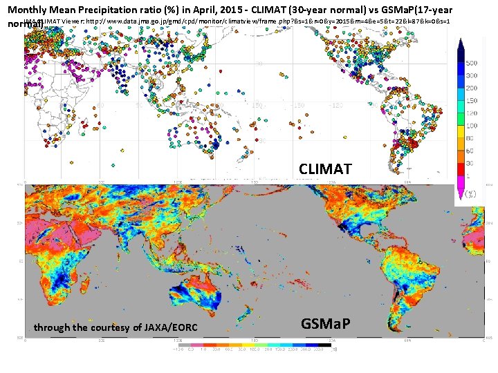
Monthly Mean Precipitation ratio (%) in April, 2015 - CLIMAT (30 -year normal) vs GSMa. P(17 -year JMA CLIMAT Viewer: http: //www. data. jma. go. jp/gmd/cpd/monitor/climatview/frame. php? &s=1&r=0&y=2015&m=4&e=5&t=22&l=87&k=0&s=1 normal) CLIMAT through the courtesy of JAXA/EORC GSMa. P
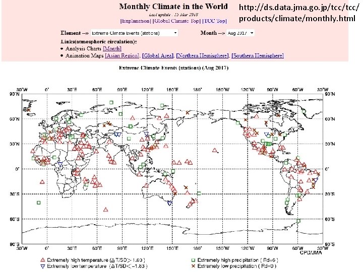
http: //ds. data. jma. go. jp/tcc/ products/climate/monthly. html SEMDP Workshop, 19 -22 March 2018, BMKG HQs, Jakarta, Indonesia
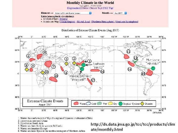
http: //ds. data. jma. go. jp/tcc/products/clim SEMDP Workshop, 19 -22 March 2018, BMKG HQs, Jakarta, Indonesia ate/monthly. html
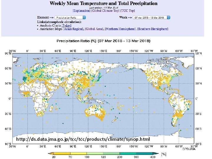
http: //ds. data. jma. go. jp/tcc/products/climate/synop. html SEMDP Workshop, 19 -22 March 2018, BMKG HQs, Jakarta, Indonesia
Q 1: What is “Weather and Climate Extremes”? SEMDP Workshop, 19 -22 March 2018, BMKG HQs, Jakarta, Indonesia

WMO Meteoterm Definition: “Extreme Weather Event“ - An extreme weather event is an event that is “rare” at a particular place and time of year. Definitions of “rare” vary, but an extreme weather event would normally be “as rare as or rarer than” the 10 th or 90 th percentile of a probability density function estimated from observations. - By definition, the characteristics of what is called extreme weather may vary from place to place in an absolute sense. - When a pattern of extreme weather persists for some time, such as a season, it may be classed as an extreme climate event, especially if it yields an average or total that is itself extreme (e. g. , drought or heavy rainfall over a season). (DEFINITION SOURCE: IPCC 5 th Assessment Report, WG 1 Glossary) SEMDP Workshop, 19 -22 March 2018, BMKG HQs, Jakarta, Indonesia
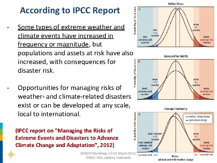
According to IPCC Report - Some types of extreme weather and climate events have increased in frequency or magnitude, but populations and assets at risk have also increased, with consequences for disaster risk. - Opportunities for managing risks of weather- and climate-related disasters exist or can be developed at any scale, local to international. (IPCC report on “Managing the Risks of Extreme Events and Disasters to Advance Climate Change and Adaptation”, 2012) SEMDP Workshop, 19 -22 March 2018, BMKG HQs, Jakarta, Indonesia
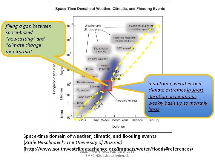
filling a gap between space-based “nowcasting” and “climate change monitoring” monitoring weather and climate extremes in short duration on pentad or weekly basis up to monthly basis Space-time domain of weather, climatic, and flooding events (Katie Hirschboeck, The University of Arizona) (http: //www. southwestclimatechange. org/impacts/water/floods#references) SEMDP Workshop, 19 -22 March 2018, BMKG HQs, Jakarta, Indonesia
Q 2: How to Identify the Extreme Values or Percentiles from satellite derived products? SEMDP Workshop, 19 -22 March 2018, BMKG HQs, Jakarta, Indonesia
Our challenging is to “identfy” the threshold values or percentiles from satellite derived products, such as precipitation, to be used for monitoring climate extremes; - If the satellite products already covers a reasonably long period (i. e. > 10 years), we can perform a calibration against co-located in situ data, so that the percentiles for the satellite derived variables are equivalent to those for the in situ data. SEMDP Workshop, 19 -22 March 2018, BMKG HQs, Jakarta, Indonesia
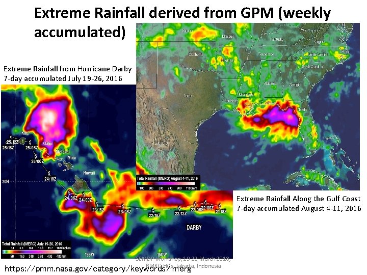
Extreme Rainfall derived from GPM (weekly accumulated) Extreme Rainfall from Hurricane Darby 7 -day accumulated July 19 -26, 2016 Extreme Rainfall Along the Gulf Coast 7 -day accumulated August 4 -11, 2016 SEMDP Workshop, 19 -22 March 2018, BMKG HQs, Jakarta, Indonesia https: //pmm. nasa. gov/category/keywords/imerg
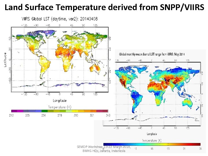
Land Surface Temperature derived from SNPP/VIIRS SEMDP Workshop, 19 -22 March 2018, BMKG HQs, Jakarta, Indonesia
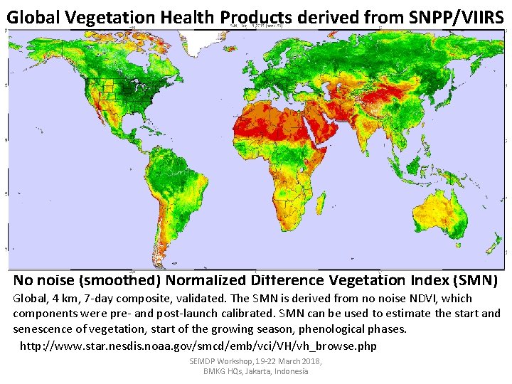
Global Vegetation Health Products derived from SNPP/VIIRS No noise (smoothed) Normalized Difference Vegetation Index (SMN) Global, 4 km, 7 -day composite, validated. The SMN is derived from no noise NDVI, which components were pre- and post-launch calibrated. SMN can be used to estimate the start and senescence of vegetation, start of the growing season, phenological phases. http: //www. star. nesdis. noaa. gov/smcd/emb/vci/VH/vh_browse. php SEMDP Workshop, 19 -22 March 2018, BMKG HQs, Jakarta, Indonesia
Q 3: Satellite Operators have already contributed to Climate Monitoring by producing TCDRs and FCDRs. It is enough !! SEMDP Workshop, 19 -22 March 2018, BMKG HQs, Jakarta, Indonesia
- TCDR and FCDR are to be produced in the “sustained architecture of climate” whereas a common and accepted definition of an Interim Climate Data Record (ICDR) is still needed to provide best practices to RCCs in setting up operations on extreme monitoring in short latency, e. g. 2 -3 days after observation. - ICDR as a CDR regularly updated with an algorithm / system having maximum consistency to TCDR generation algorithm / system. The update cycle depends on the user needs for climate extremes and might range from pentad to monthly. SEMDP Workshop, 19 -22 March 2018, BMKG HQs, Jakarta, Indonesia
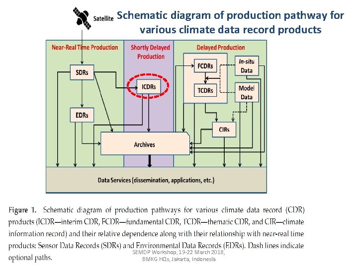
Schematic diagram of production pathway for various climate data record products SEMDP Workshop, 19 -22 March 2018, BMKG HQs, Jakarta, Indonesia
Q 4: What is SEMDP produced by WMO? SEMDP Workshop, 19 -22 March 2018, BMKG HQs, Jakarta, Indonesia
General Objective of SEMDP is a framework to foster a dialogue amongst satellite operators, WMO Regional Climate Centres (RCCs) and NMHSs; - to guide NMHSs and relevant institutes to be able to properly and practically use the space-based observation data and products for monitoring selected ‘Weather and Climate Extremes’ with a focus on ‘persistent heavy/little rainfall’ and ‘drought’ - on a routine basis for climate extremes monitoring/diagnostics, and for the development of improved climate services. SEMDP Workshop, 19 -22 March 2018, BMKG HQs, Jakarta, Indonesia
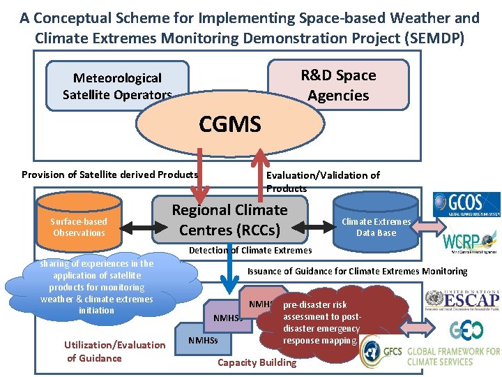
A Conceptual Scheme for Implementing Space-based Weather and Climate Extremes Monitoring Demonstration Project (SEMDP) R&D Space Agencies Meteorological Satellite Operators CGMS Provision of Satellite derived Products Surface-based Observations Evaluation/Validation of Products Regional Climate Centres (RCCs) Climate Extremes Data Base Detection of Climate Extremes sharing of experiences in the application of satellite products for monitoring weather & climate extremes initiation Utilization/Evaluation of Guidance Issuance of Guidance for Climate Extremes Monitoring NMHSs pre-disaster risk assessment to post. NMHSs disaster emergency response mapping. NMHSs Capacity Building

The GPCLRFs and the RCCs constitute integral components of WMO's Global Data Processing and Forecasting System (GDPFS) underpinning the generation of climate information products by the NMHSs.
Outline of the SWCEM Demonstration Project (SEMDP) • The 2 -year SEMDP will concentrate on products at national and regional levels. Items to be worked on include: (i) monitoring persistent heavy/little precipitation and droughts; (ii) making best use of existing and newly developed satellite derived products and time series of measurements; (iii) making best use of products that combine satellite information with in-situ and/or model reanalysis data; (iv) recommendations as to which products should be transitioned from research to operations, including an assessment of those products. • A final report of the SEMDP will be compiled and reviewed in the end of the Demonstration Phase. The next steps will then be endorsed based on the outcome. SEMDP Workshop, 19 -22 March 2018, BMKG HQs, Jakarta, Indonesia
- The SEMDP is planned to develop an operational technique to utilize satellite derived products with CLIMAT and/or SYNOP data for the enhanced monitoring of extreme events; i. e. persistent heavy/little rainfall, and drought. - Through the case study in SEMDP, satellite derived products will be reviewed and validated with CLIMAT and/or SYNOP data. - It is a goal to do the enhanced monitoring of persistent heavy/little rainfall, and drought over relatively short periods from pentad (5 -day), a week, up to a month using satellite data. SEMDP Workshop, Jakarta, Indonesia, 19 -22 March 2017 34
Q 5: Why RCCs will not use satellite products for climate monitoring? SEMDP Workshop, 19 -22 March 2018, BMKG HQs, Jakarta, Indonesia
- “Climate Normal (30 years )” will not be available for satellite products (e. g. precipitation), excepting Outgoing Long wave Radiation (OLR), Snow Coverage, Sea Ice Coverage? If so, the next “Climate Normal” for 1991 - 2020 will be a good opportunity to encourage RCCs to use satellite products to use. - Difficulties in combining satellite products with CLIMAT/SYNOP data? If so, experiences in NOAA/NWS/CPC would be a good “teacher” for the utilization of satellite products. - There is no common procedure and tool available in operation for utilizing satellite products? If so, SEMDP will be a good opportunity to develop such a technique. SEMDP Workshop, Jakarta, Indonesia, 19 -22 March 2017 36
Thank you SEMDP Workshop, 19 -22 March 2018, BMKG HQs, Jakarta, Indonesia
- Slides: 37