Overview of the Colorado Basin River Forecast Center

Overview of the Colorado Basin River Forecast Center Lisa Holts
 River Forecasts Recreational Forecasts (River trends –")
What we do…. Event Driven (rain, snowmelt) River Forecasts Recreational Forecasts (River trends – Peak Flows) Support Flash Flood Program Water Supply => Reservoir Management Our Mission: Protection of lives and property – Enhancement of the nation’s economy WFO and RFC partnership Colorado Basin River Forecast Center

Daily River Forecasts and Flood Forecasts § § Collect and QC data Run Hydrologic Model Produce daily river forecasts Manual forecast updates at – 6: 30 am, 11: 00 am, 4: 00 pm § Automated forecast updates at – 12: 00 am § During floods… updates as needed/requested

Hydrologic Forecasting Inputs/Outputs Precipitation Estimates Satellite Data Reservoir River Gage Data Releases Radar Data Hydrologic Modeling Snow Precipitation Forecasts Temperature Forecasts Soil Moisture States Deterministic / Probabilistic River Forecasts

NOAA NWS Mountain Mapper – Daily QC

Precipitation Input § Multisensor Precipitation Estimates – MPE – Gage – Radar – Satellite

Grids format

MAP
 5 days of QPF")
Future Precipitation & Temperature & Freezing Level Point Values (HPC) 5 days of QPF 10 days temperatures Basin Values Grid Values (Prism Scaling)

GFE § Increased leverage of GFE – View QPF differences between sources – Allows WFO to view QPF going into the model § Make adjustments in specify still § Future: will just use GFE and eliminate specify

Example Display From NWSRFSInteractive Forecast Program Simulated -* Observed - O Adjusted=Forecast

Processing IFP Data Table

Processing IFP Runtime Modifications

Processing IFP Unit Hydrograph Modification

Example: Hydrograph Plot CBRFC Web Site NWSRFS Segments 500 River Forecast Points 165

Forecast Limitations Quality of forecast depends on inputs Observed precipitation Observed flow Model states QPF Future Temperature NWSRFS Model Data availability and Future uncertainty

Data sparse in Northern Arizona

Forecast Limitations Future Uncertainty - Precipitation Amounts & Timing Are Perfect: BUT Wrong Basin Forecast 2. 00” Result 2. 00” 1. 00” Flood Stage No Rise Colorado Basin River Forecast Center 1. 00”

Forecast Limitations Future Uncertainty - Precipitation Basin Is Right: BUT Forecast Amounts Too High Forecast 2. 00” Result 1. 00” 1. 00 0. 50” Flood Stage Peaks Lower Colorado Basin River Forecast Center

NOAA Forecast Limitations Future Uncertainty - Precipitation NWS Basin Is Right: BUT Forecast Amounts Too Low Forecast 2. 00” Result 1. 00” 3. 00 2. 00” Flood Stage Peaks Higher Colorado Basin River Forecast Center

NOAA Forecast Limitations Future Uncertainty - Precipitation NWS Basin Is Right-Amounts are Right: wrong intensity Forecast For 24 Hours 2. 00” 1. 00” Result: Packed Into 6 hours 2. 00 1. 00” Flood Stage Peaks Faster & Higher Colorado Basin River Forecast Center

NWS River Forecasting System NWSRFS § Collection of models and processes § Three components – Calibration System – Operational Forecasting System – Ensemble Streamflow Prediction

NWSRFS-Three Components

Poorly Calibrated Basin Simulated Observed

Much Better Calibrated Basin Simulated Observed
 § § § Preprocesses observed and future data Updates model")
Operational Forecast System (OFS) § § § Preprocesses observed and future data Updates model state parameters Provides short-term river and flood forecasts – 0 to 14 days out

Interactive Forecast Program
 § Uses historical precipitation, temperature and evaporation data § Uses")
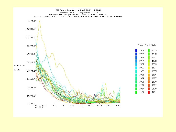
Ensemble Streamflow Prediction (ESP) § Uses historical precipitation, temperature and evaporation data § Uses current model states § Produces mid- to long-range probabilistic forecast (weeks to months into the future)

Ensemble Streamflow Prediction Climate Forecast Adjustments Daily RFC Forecasting • Data Ingest • Data QC • Model Updating Current Conditions • Soil • Reservoir Levels • Streamflow April-July Historical Time Series Mean Areal Time Series Precipitation Temperature Forecast Time Series NWSRFS Hydrologic Models Streamflow All Years of Record Time

Ensemble Stream. Flow Prediction Future Streamflow Today’s Conditions River / Res. Levels Soil Moisture Snowpack Past <71 72 73 74 75 1971 1972 1973 1974 1975 -> Future Time 1971 Temperature Precipitation Start with Today’s Conditions - Create several possible future streamflow patterns - Based on historical climate.

Supporting the Flash Flood Program § NWSRFS – Lumped 6 hourly model § CBRFC has recalibrated Arizona segments to an hourly time step § blurred line when RFC can or cannot model event § For flash floods, RFC provides tools to help WFO decide when to issue FFWs – FFG, FFPI

Flash Flood Potential Index concept Land Use ? Soil type ? Vegetation type and density ? Try to qualify the flash flood threat Highlight flash flood prone areas Fire activity ? Slopes?

Water Supply Operations § Volumetric forecast for the runoff season § Essential to water managers (dam operations, water allocation, water planning, etc. . ) § Issues January through July § forecasters devote first 4 days of the month to water supply forecasting § 146 water supply forecast points § Spring is the busiest time for the RFC

Water Supply § Monthly water supply forecasts generated for seasonal volumes during winter / spring seasons

Questions?
- Slides: 36