Overview of 201819 Winter Climate over South Korea

- Slides: 14

Overview of 2018/19 Winter Climate over South Korea @ FOCRAII 2019 9 th May, 2019 Juyoun Lim, Jeong-Hee Choi, Seong-Eun Lee, Su-Jeong Kim, Dong-Joon Kim, Sung-Ho Woo* Climate Prediction Division, KMA * Chonnam national university

Outlines 2018/19 Winter weather over South Korea - Temperature & Rainfall - Trend of temperature 2018/19 Winter climate characteristics - ENSO - Stratospheric Sudden Warming - Sea Ice 2018/19 Winter monthly weather characteristics over South Korea - Cold spell on December - Warm and dry weather on January Summary

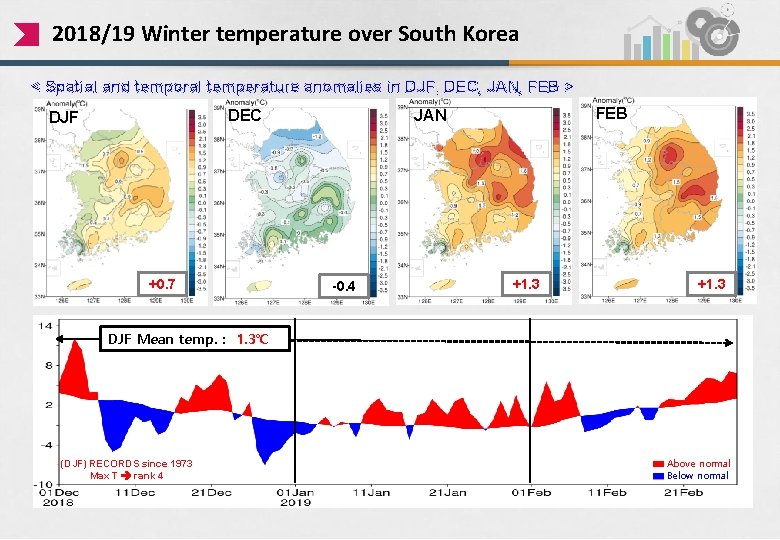
2018/19 Winter temperature over South Korea < Spatial and temporal temperature anomalies in DJF, DEC, JAN, FEB > +0. 7 FEB JAN DEC DJF -0. 4 +1. 3 DJF Mean temp. : 1. 3℃ (DJF) RECORDS since 1973 Max T rank 4 Above normal Below normal

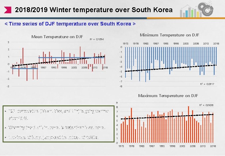
2018/2019 Winter temperature over South Korea < Time series of DJF temperature over South Korea > Mean Temperature on DJF 3 Minimum Temperature on DJF R 2 = 0, 1094 0 2 1978 1983 1987 1993 1998 2003 2008 2013 2018 -1 1 0 1973 -2 -3 1978 1983 1987 1993 1998 2003 2008 2013 -4 2018 -1 -5 -6 -2 -7 -3 R 2 = 0, 0917 -8 Maximum Temperature on DJF 9 R 2 = 0, 0638 8 • DJF temperature (Mean, Max, and Min) is going warmer after 1973. • Warming trend of Min. temp. is faster than Max. temp. • The trend of temp. jumped at the middle of 1980 s. 7 6 5 4 3 2 1 0 1973 1978 1983 1987 1993 1998 2003 2008 2013 2018

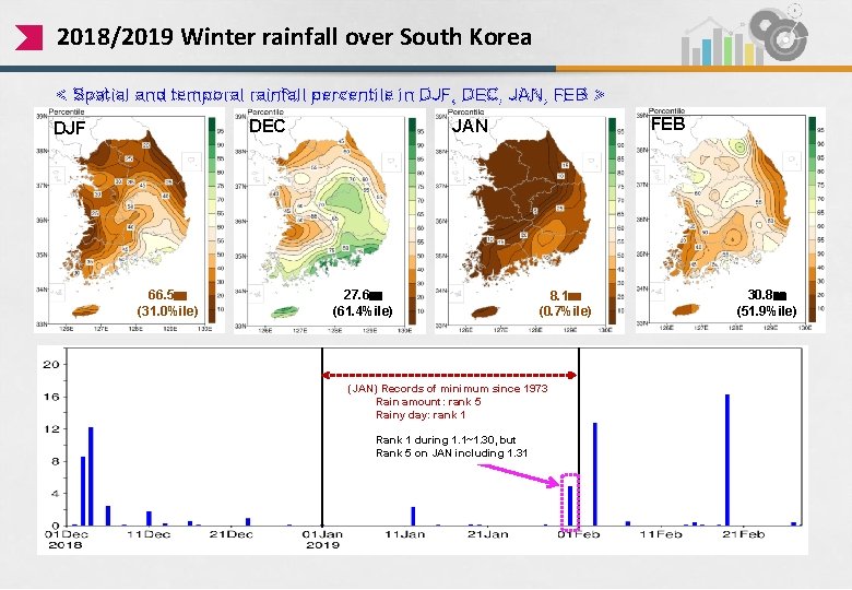
2018/2019 Winter rainfall over South Korea < Spatial and temporal rainfall percentile in DJF, DEC, JAN, FEB > 66. 5㎜ (31. 0%ile) FEB JAN DEC DJF 27. 6㎜ (61. 4%ile) 8. 1㎜ (0. 7%ile) (JAN) Records of minimum since 1973 Rain amount: rank 5 Rainy day: rank 1 Rank 1 during 1. 1~1. 30, but rank 1 during 1. 1~1. 30, Rank 5 on JAN including 1. 31 30. 8㎜ (51. 9%ile)

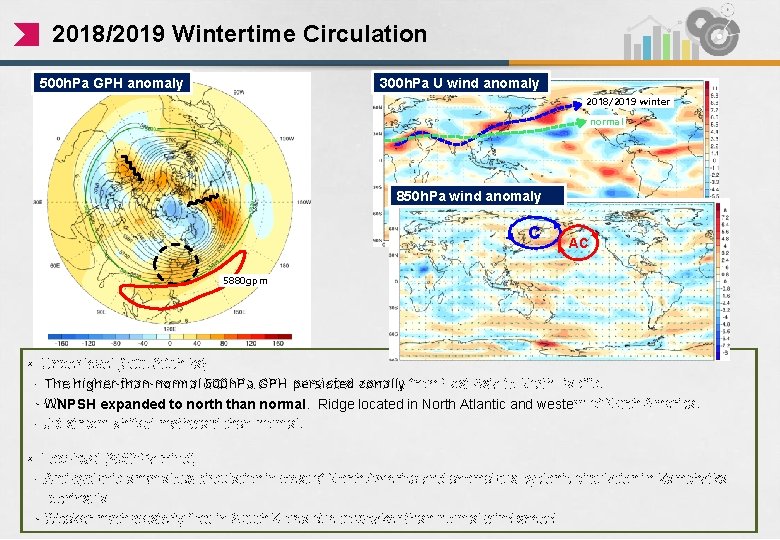
2018/2019 Wintertime Circulation 300 h. Pa U wind anomaly 500 h. Pa GPH anomaly 2018/2019 winter normal 850 h. Pa wind anomaly C AC 5880 gpm • Upper-level (500, 300 h. Pa) - The higher-than-normal 500 h. Pa GPH persisted zonally from East Asia to North Pacific. - WNPSH expanded to north than normal. Ridge located in North Atlantic and western of North America. - Jet stream shifted northward than normal. • Low-level (850 h. Pa wind) - Anti-cyclonic anomalous circulation in west of North America and anomalous cyclonic circulation in Kamchatka peninsula - Weaker north-westerly flew in South Korea due to weaker-than-normal wind speed

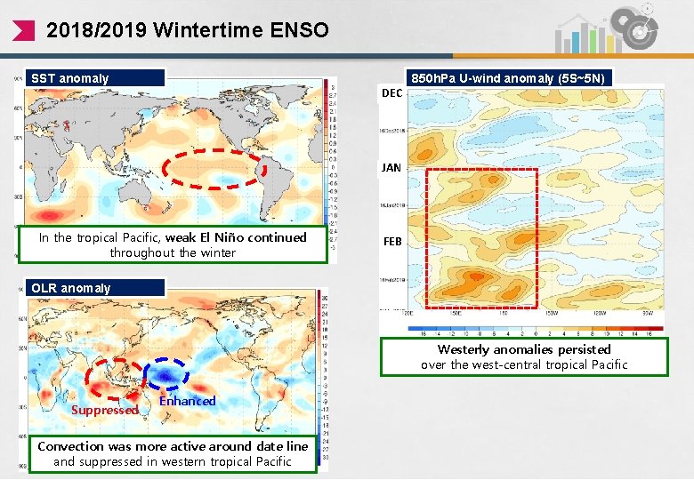
2018/2019 Wintertime ENSO SST anomaly DEC 850 h. Pa U-wind anomaly (5 S~5 N) JAN In the tropical Pacific, weak El Niño continued throughout the winter FEB OLR anomaly Westerly anomalies persisted over the west-central tropical Pacific Suppressed Enhanced Convection was more active around date line and suppressed in western tropical Pacific

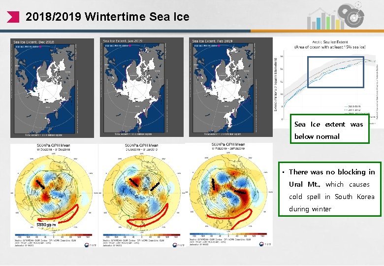
2018/2019 Wintertime Sea Ice extent was below normal • There was no blocking in Ural Mt. , which causes cold spell in South Korea during winter 5880 gpm

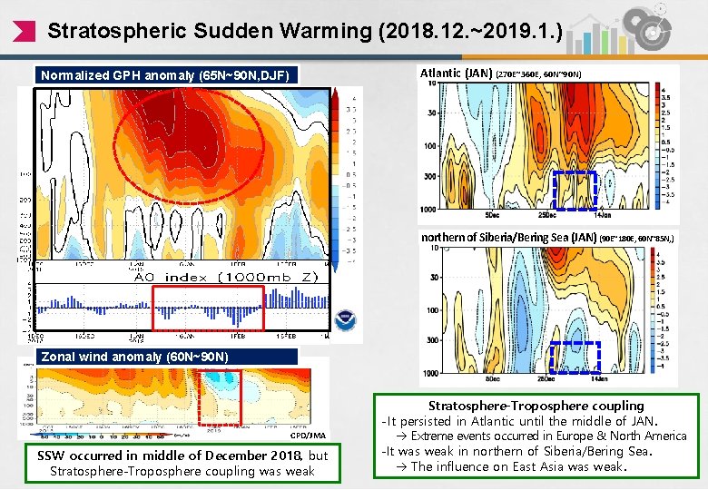
Stratospheric Sudden Warming (2018. 12. ~2019. 1. ) Atlantic (JAN) (270 E~360 E, 60 N~90 N) Normalized GPH anomaly (65 N~90 N, DJF) northern of Siberia/Bering Sea (JAN) (90 E~180 E, 60 N~85 N, ) Zonal wind anomaly (60 N~90 N) CPD/JMA SSW occurred in middle of December 2018, but Stratosphere-Troposphere coupling was weak Stratosphere-Troposphere coupling - It persisted in Atlantic until the middle of JAN. Extreme events occurred in Europe & North America -It was weak in northern of Siberia/Bering Sea. The influence on East Asia was weak.

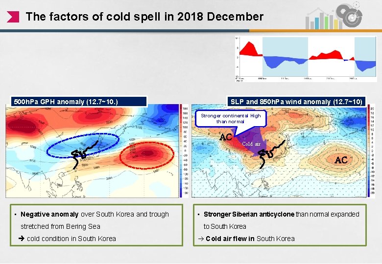
The factors of cold spell in 2018 December 500 h. Pa GPH anomaly (12. 7~10. ) SLP and 850 h. Pa wind anomaly (12. 7~10) Stronger continental High than normal AC Cold air AC • Negative anomaly over South Korea and trough stretched from Bering Sea cold condition in South Korea • Stronger Siberian anticyclone than normal expanded to South Korea Cold air flew in South Korea

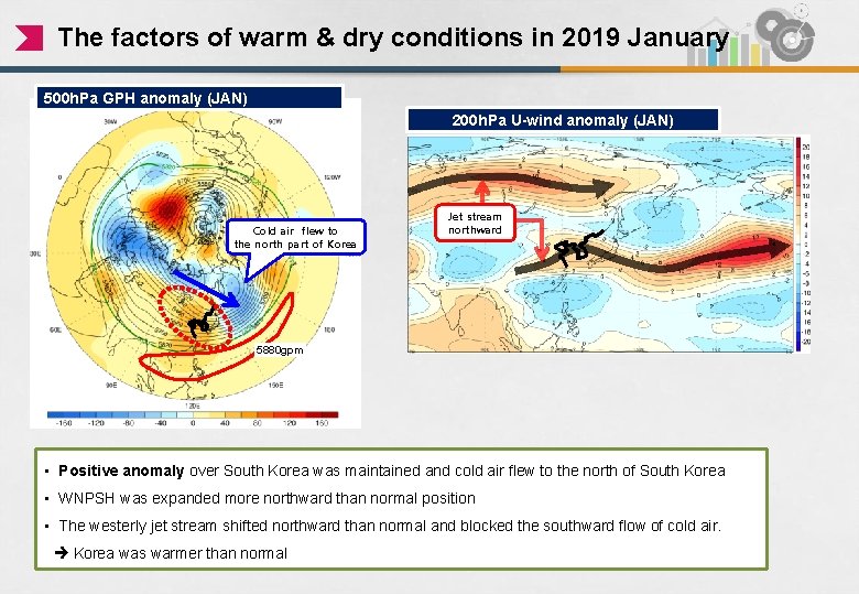
The factors of warm & dry conditions in 2019 January 500 h. Pa GPH anomaly (JAN) 200 h. Pa U-wind anomaly (JAN) Cold air flew to the north part of Korea Jet stream northward 5880 gpm • Positive anomaly over South Korea was maintained and cold air flew to the north of South Korea • WNPSH was expanded more northward than normal position • The westerly jet stream shifted northward than normal and blocked the southward flow of cold air. Korea was warmer than normal

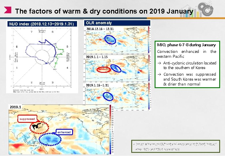
The factors of warm & dry conditions on 2019 January MJO index (2018. 12. 13~2019. 1. 31) OLR anomaly 2018. 12. 16 – 12. 31 MJO, phase 6 -7 -8 during January 2019. 1. 1 – 1. 15 Convection enhanced in the western Pacific Anti-cyclonic circulation located to the southern of Korea 2019. 1. 16 – 1. 31 Convection was suppressed and South Korea was warmer & drier than normal 2019. 1 suppressed • Stronger continental anticyclone than enhanced normal extended to South Korea Cold air flew in • lowest rain amount (0. 0 mm) and snow amount (0. 0 cm) in Seoul since 1907 and 1937, respectively

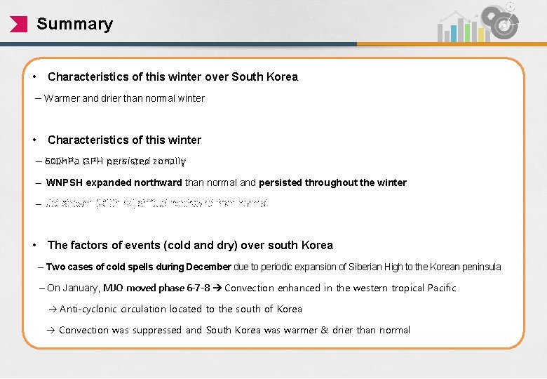
Summary • Characteristics of this winter over South Korea – Warmer and drier than normal winter • Characteristics of this winter – 500 h. Pa GPH persisted zonally – WNPSH expanded northward than normal and persisted throughout the winter – Jet stream (300 h. Pa) shifted northward than normal • The factors of events (cold and dry) over south Korea – Two cases of cold spells during December due to periodic expansion of Siberian High to the Korean peninsula – On January, MJO moved phase 6 -7 -8 Convection enhanced in the western tropical Pacific Anti-cyclonic circulation located to the south of Korea Convection was suppressed and South Korea was warmer & drier than normal

Thank you