Overview 70 8 of Earth covered by ocean

Overview 70. 8% of Earth covered by ocean 97. 2% of surface water Interconnected global or world ocean

Principal oceans Pacific Largest, deepest Atlantic Second largest Indian Mainly in Southern Hemisphere

Arctic Smallest, shallowest, Northern Hemisphere Antarctic Connects Pacific, Atlantic, and Indian

Comparison and of land depth Average depth of ocean 3729 m Average elevation of land 840 m Deepest ocean Mariana Trench 11, 022 m Highest mountain Mt. Everest 8850 m

History of Oceanography 1. Principles of Marine Science emerge gradually over time, constrained by 2. religion, sociology, technology. Polynesian voyages in the Pacific Arabs/Indians sail the Indian Ocean Chinese ships explore African coast Europeans explore the world oceans 3. Motivations: riches, food and war

Why do we speak languages from Europe? Indigenous people lived here right? The Chinese had huge ships with lots of supplies right? The Polynesians explored the Pacific first right?
![Polynesia: the first voyagers 1. By 2, 500 years [BP] almost all Pacific Islands](http://slidetodoc.com/presentation_image_h2/0ef2423432cc0d406c9473cc48df5405/image-7.jpg "Polynesia: the first voyagers 1. By 2, 500 years [BP] almost all Pacific Islands")
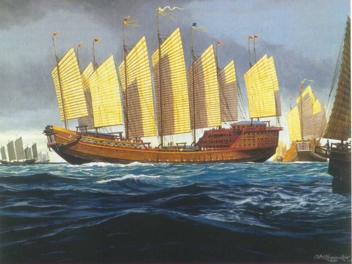
Polynesia: the first voyagers 1. By 2, 500 years [BP] almost all Pacific Islands except Hawaii were colonized. 2. Outrigger canoes can tack into wind but narrow hulls hold little cargo and hulls rack in strong seas. 3. Navigated by stars, but no written language, so knowledge of stars was memory dependent. Stick charts in some cultures 4. Voyaging limited by number of coconuts/boat. Coconuts supplied food, water and vitamin C.

Voyaging Outrigg er

Arab/Indian dhows, the Indian Ocean and the seasonal monsoon 1. Large lateen rigged ships; large cargoes for trading. 2. Shallow draft ships with huge center boards don’t tack well, but fast down wind. 3. Monsoon winds in Indian Ocean blow from east for 6 months and from west for 6 months. 4. Indian Dhows into South Atlantic, probably to South America, in 1420.

Chinese ocean voyaging 1. Chinese junks have full battened sails; tack easily into the wind. 2. Big hulls, large holds, lots of water, good provisions. 3. From 1417 1433 Chinese built super junks, up to 440 ft long for coastal trade (no navigation). 4. Chinese invented the Compass! 4. Found no new markets; Admiral Cheng Ho was beheaded; ships were burned.

European 1. Belief in a flat earth constrained voyagi exploration. ngrigged ships have big hulls with 2. Square large cargoes, but only sail down wind. 3. Navigation: sextant gives azimuth of sun for latitude, but longitude was measured by dead reckoning because 4. pendulum clocks won’t work on a rolling ship. Needed new clocks. 5. No coconuts! Scurvy kills after few months of no vitamin C (ascorbic acid).

HMS

Who wins the exploration sweepstakes ? 1. Polynesians? No. No written language; limited cargo space constrained warfare and trade. 2. Arabs? No. Only one east west trade route. 3. Chinese? No. Rigid autocracy not healthy for ambitious Admirals. 4. Europeans? Yes!!! Boat design was dumb but big. Discovered clocks and limes, then raped and pillaged new world with Guns, Germs, and Steel in the “Discovery” of the new world.
")
Motives for European Exploration: food, 1. New lands: Norse explorations riches, war (@1000) but native Americans were too feisty. 2. New fish stocks: Basques fished for cod off Newfoundland (@ 1200 AD), but no one told! 3. Spices and gold: Columbus (1492) sails down wind via trades to Caribbean. Spanish begin to plunder new world. Magellan sails down wind around the world (1522), and Spanish pillage Philippines for 250 years. 4. Exploration: British (1768) send Captain James Cook with Harrison’s chronometers on 3 round the world voyages…all cruises down wind.

Columbus, Magellan, Cabot
")
Ship track of Cook’s voyages (1768 178 0)
")
Darwin and the Voyage of the Beagle (1831 36)

Coral reels on side ot l. Allcano, b· Fringing reef a Active volcano lagoon Reefs grow upward c Banier reef d Atoll
")
Matthew Maury (1885)
")
Voyage of the Challenger (1872 75)
 1888 Woods Hole 1892 Hopkins Marine Station")
First Marine Laboratories 1872 Statione Zoologica (Naples) 1888 Woods Hole 1892 Hopkins Marine Station 1905 Scripps

Significant discoveries and dates in oceanography 1. Alfred Wegner poses continental drift in 1912. 2. William Beebe and Otis Barton build Bathysphere in 1928; dive off Bermuda. “Half mile Down” 1934 3. World War II boosts submarine design and construction. Echo soundings used by military to map Atlantic and Pacific Oceans. Deep scattering layer. 4. Jacques Cousteau and Emile Gagnan invent the aqualung 1943. 5. Plate tectonics re discovered 1960’s. 6. Sea. Sat 1978; First ocean observing satellite.

Russian submers ible “Mir”

Wasp submersible

Diving in blue water

ROV Ventana

Sea. Satellite view of Gulf stream: warm core and cold core
- Slides: 28