OVERLOOK ON THE DANUBE RIVER BASIN HYDROLOGICAL FORECAST
 MOJAC ŠRAJ 1, MITJA")
OVERLOOK ON THE DANUBE RIVER BASIN HYDROLOGICAL FORECAST (DARREFORT PROJECT) MOJAC ŠRAJ 1, MITJA BRILLY 1, MIRA KOBOLD 2, SAŠO PETAN 2 ANDREJ VIDMAR 1 1 FACULTY OF CIVIL AND GEDETICS ENGINEERING 2 SLOVENIAN ENVIRONMENT AGENCY U N I V E R S I T Y O F L J U B L J A N A , F A C U L T Y O F C I V I L A N D G E O D E T I C E N G I N E E R I N G , D E P A R T M E N T O F E N V I R O N M E N T A L C I V I L E N G I N E E R I N G , L J U B L J A N A , S L O V E N I A Kyiv, Ukraine, November 6 -8, 2019

Introduction v. DAREFFORT - Danube River Basin Enhanced Flood Forecasting Cooperation v 2018 -2021 v 11 2 artners and 12 Associated partner v 7 WP vhttp: //www. interreg-danube. eu/approved-projects/dareffort

Objectives v. A forecasting system that is based on the cooperation between the Danube Basin countries is the main objective of DAREFFORT project. v. Integration of existing and future hydrometeorological data sources v. Provide a tool for collecting, storing, analysis and reporting of the near real-time hydrological data in the DRB v. The Danube HIS: Providing Danube basin-wide level basic hydrological and meteorological near real time data in a standard format, and, if possible, the validated long-term data series, for flood risk management or for any water related scientific activities in DRB

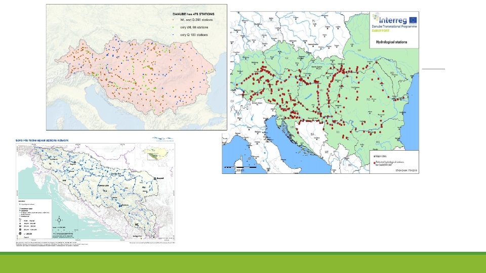
WP 3 Evaluation of forecasting • Output 3. 1 – Evaluation report on flood and ice forecasting (UL) o Deliverable 3. 1. 1 – Flood and ice forecasting system country factsheets (All partner countries) o Deliverable 3. 1. 2 – Map of networks, core observation stations (prepared by STASA based on the chapter „Stations for the Danube HIS“ of the Output 3. 1 and ICPDR GIS system) o Deliverable 3. 1. 3 – Evaluation report of questionnaire (prepared by UL)

Flood and ice forecasting system country factsheets leading partner – University of Ljubljana Flood and ice forecasting system country factsheets Country reports, ISPRA and Sava River Basin report Deliverable: 3. 1 Flood and ice forecasting system country factsheets (All partner countries)

Number of stations considered in the Danube HIS

Travel times of the highest floods between Passau and Nagymaros. (Source: Pekárová et al. , 2018)

The lead time between the forecast and the event is extremely important for implementing various measures of protection and defense against floods. The development and efforts of the services focus on prolonging the lead time using state-of-the-art information technology
")
Systematic assessments of forecasts are only done by European Commission’s Joint Research Centre (JRC) – for its EFAS forecasts, covering EU member states and associate members. In terms of forecasting accuracy assessment, the level of confidence into flash floods forecasting and forecasting of floods in the middle and lower river reaches cannot be assessed in the same way. The reason lies in the weak reliability of meteorological forecasts, even with only 24 -hour lead time.

Questions: Number of WS stations drop down in the past decades. Lack of measurement of real evapotranspiration, soil moisture, snowfall, snow cover water equivalent Digitalisation of historical data is lacking in all services. The floods in the Danube river basin are mainly generated in mountainous areas in combination with snowmelt. In most countries there are no systematic measurements of water equivalent in snowpack or its spatial distribution. On hydrological stations there are practically no systematic measurements of water velocity undertaken, by water velocity meter probe. Only water levels are measured rather than impacts of back water at estuaries of major rivers or obstacles to the water flow. Bed load transport is hardly ever measured. Suspended solids in water are occasionally measured, but that is no subject of our report. There also no systematic measurements of channel morphology, with the exception of navigable waterways along the Danube and its tributaries.

Hydrological reports on floods are made per individual year and individual country, but there are no such reports available on the basin-wide scale. ICPDR has organized the production of some flood reports in some years in which general data and descriptions of the occurrence of floods and their consequences are provided (ICPDR 2006, 2010, 2013 and 2014). Unfortunately, there are no comprehensive hydrological analyzes of an event, including hydrographs from which it would be evident how the flood waves formed in the basin, the proportion of volume and maximum flows involved tributarie inflows, what caused the flood: rain, snow melting, their combination, extraordinary preliminary soil moisture, coincidence of flood waves during the flow in the main stream and tributaries, the time of the flood wave along the flow.

On the Danube River stream and its tributaries there are many dams in place, which serve various purposes, including hydropower production and water supply. All these structures dam water in the channel and, with their volume, affect the water flow. How is operation of these reservoirs included into the work of hydrological forecasting services is not known. Data exchange is of course in place, but not also prediction of operation of the reservoirs and their impact on flow forecasts. Good example is 2012 year flood on the Drava River.

Thank you for your attention.
- Slides: 14