Overlay Operations Overlay Operations Overlay Operations involve combining

Overlay Operations

Overlay Operations • Overlay Operations involve combining spatial and attribute data from two or more spatial data layers. “Stacking data” – Very powerful and popular operations – Examples of overlays? • Overlays require that data be in the same coordinate system

Vector Overlay • Vector Overlay involves combining point, line, polygon geometry and associated attributes – Overlay creates new geometry • Large attribute tables may result if overlay operations combine many layers – Duplicate attribute fields may also exist.

Basic Cases of Overlay - Clip • Clip defines the areas for which features will be output based on a ‘clipping’ polygon • Attributes of clipping layer not transferred to clipped data Clipping Layer + Data Layer Result Layer

Basic Cases of Overlay - Intersection • Intersection combines data from at least two layers but only for region where all layers contain data • Similar to Clip, but the attributes are transferred to the output data Data Layers A B Result Layer A, B

Basic Cases of Overlay - Union • Union is an overlay that includes all data from all of the input data layers • No geographic data are discarded in the union operation and corresponding attribute data are saved for all regions. Data Layers A B Result Layer A A, B B

Vector Overlay Problems • Common Features represented in both layers, but with slightly different geometry • This creates sliver polygons when the overlay operations are performed • Several methods exist to reduce the occurrence of sliver polygons.
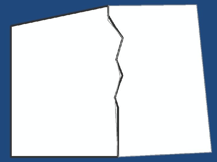

Sliver Polygons
- Slides: 9