OS Master Map data and Building Heights Arc

OS Master. Map data and Building Heights – Arc. GIS Ian Holmes EDINA Geo User Support

Content Downloading Building Height data from Digimap Data formats 3 D visualisation in Arc. GIS Pro Tips: • apply realistic facades • combining other datasets • Further information resources • •

How do I download Building Height data? • Data Download – download OS and other mapping data for use in Arc. GIS

Using Data Download Three steps: 1. Select area 2. Choose data 3. Add to basket options to change format, version and layers

Data Download Click + or on category name to open and see available map data products: • OS Master. Map – most detailed topographic mapping of GB, includes Building Heights • Backdrop Mapping – raster maps at range of scales, all in TIFF format • Land Height data – contours and Digital Terrain Models • Vector data – range of scales and formats • Boundary and Location data – administrative boundaries, postcode data, gazetteers • Withdrawn datasets

Data Formats • Building Heights supplied by OS in CSV format as a single file containing over 20 million features • Digimap provides Building Height data in: – CSV format – KML format, for use in Google Earth – File. Geodatabase, for use in Arc. GIS and QGIS • Building Height data from Digimap is provided in 5 x 5 km tiles

Basket options • Select version, format and layers in the basket. • Options vary between map data products. • For Building Heights and Topography, change the format to File Geodatabase

Poll – have you used OS Building Height Attribute before? • Yes • No If you have used OS Building Heights before please use the chat box to tell us what software have you used it in (e. g. Arc. Map, QGIS, Auto. CAD Map 3 D, Google. Earth etc. )

Building Height Attribute data • ‘Alpha’ release, so not guaranteed to be 100% accurate • Latest version ‘Alpha 3’, released December 2014

Building Height Attribute data • Incomplete coverage, see interactive map on OS website for current extents

Introduction to Arc. GIS Pro • What is Arc. GIS Pro? – – A new application that is part of Arc. GIS Desktop It is not a replacement for Arc. Map Improved 3 D visualisation capabilities Faster? • What do I need to get Arc. GIS Pro? – Valid Arc. GIS Desktop licence – Arc. GIS Online account

Visualising buildings in 3 D in Arc. GIS Pro • Create a Project • Add a Map to the Project • Add data to the map (buildings, backdrop mapping, plus any additional layers) • Set the projection and transformation in the map • Convert the map to a ‘local scene’ • Add any local, more detailed, terrain models e. g. OS Terrain 5 • Extrude the buildings

Arc. GIS Pro – Live demo

Arc. GIS Pro – Getting Started • Create a new Project • Add a new Map to the project • Add data to the map (buildings, backdrop mapping, plus any additional layers)

Arc. GIS Pro – set coordinate system and transformation ESRI Basemap data is in WGS 84, OS data is in OSGB 36 so one of the datasets has to be reprojected: • Default transformation ~100 m out • OSTN 02 transformation is accurate to +/- 2 m • Petroleum transformation accurate to +/- 5 m Note: petroleum transformation is built in to Arc. GIS, OSTNO 2 transformation has to be added. Instructions on adding it available here.

Arc. GIS Pro – Convert to 3 D • View > Convert – this creates a second layout in the project document called ‘Map_3 D’, you may need to ‘zoom to layer’ to see your data • Add in more detailed terrain model e. g. OS Terrain 5: – Map > Add Preset > Ground – Browse to the DTM – Note you can apply vertical exaggeration if you wish

Arc. GIS Pro – Extrude Buildings • Drag your building layer from the ‘ 2 D Layers’ group to the ‘ 3 D Layers’ group • On the Appearance tab, use the Type drop down in the Extrusion group to select an appropriate extrusion method, e. g. ‘Min Height’ • In the field selector drop down select an appropriate attribute to use for the extrusion, e. g. [relhmax] Note: you can apply vertical exaggeration using the Expression Builder e. g. [relhmax]*1. 5 will cause buildings to be drawn 50% taller than they actually are

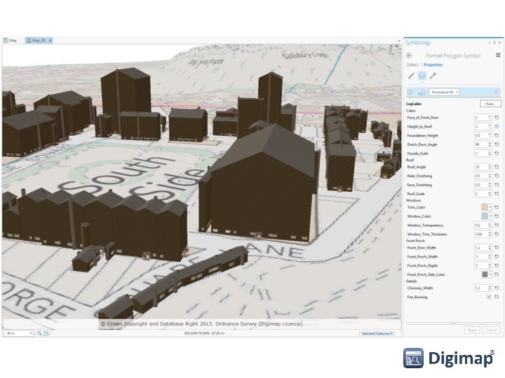
Arc. GIS Pro – Symbology • Basic symbology set using ‘standard’ settings • More realistic symbology set using ‘Procedural Symbols’. Note: Procedural Symbols need to be added to the Arc. GIS Pro project: Insert > Add Style > Add System Style > select 3 D • Select the ‘International Building’ symbol Note: Procedural Symbols will override any previously defined height extrusion settings. • Restore correct extrusion via: Symbology > Properties > Layers > Total Height > Set Attribute Mapping and select [relhmax] or use the Expression Builder if you wish to set a vertical exaggeration

Arc. GIS Pro - Facades • More complex facades can be set up using City. Engine • Export rules from City. Engine to a ‘Rule Package File’ • Import Rule Package File in to Arc. GIS Pro following these instructions • Remember to update any height values to use an appropriate attribute if all buildings drawn with the same height

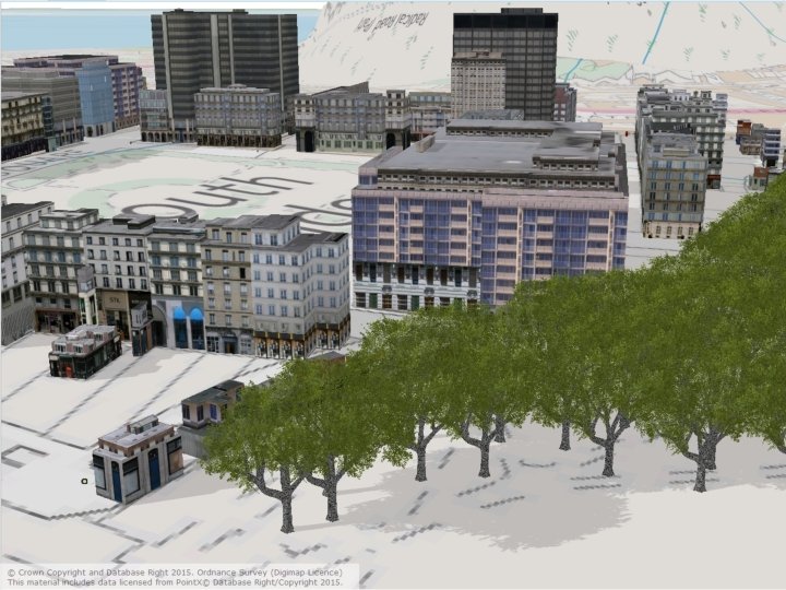
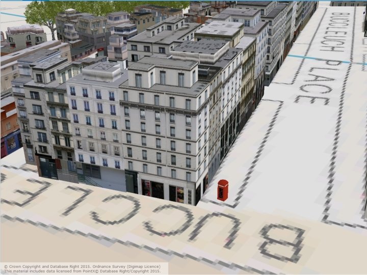
Arc. GIS Pro – combining other datasets • Point features from OS Master. Map e. g. Positioned Trees • Points of Interest data e. g. Bus Stops, Post Boxes, Phone Boxes • OS Master. Map Sites Layer showing outlines of important sites • Turn on shadows: Map Properties > Illumination > Display shadows in 3 D

Further Information – Building Height Attribute The following information is available directly from Ordnance Survey: • • • Getting Started Guide Release Notes (December 2014) Interactive Coverage Map User Guide Technical Specification

Further Information – Using BHA Instructions on using BHA in common GIS/CAD packages are available in the Digimap Help system: • • ESRI's Arc. GIS and Arc. Globe ESRI's Arc. GIS Pro Auto. CAD Map 3 D and Infra. Works QGIS

Further Information – Arc. GIS Pro Extensive help documentation and tutorials for Arc. GIS Pro and City. Engine are available online, links to the key ones below: • • Gallery of downloadable ESRI Rule Packages Getting started with Arc. GIS Pro (tutorial from ESRI) Extrusion types explanation City. Engine help

Resources • Digimap Resource centre – access help pages, guides, FAQs, videos, case studies and more.

Help pages Digimap Resource centre: http: //digimap. edina. ac. uk/webhelp/resources/index. html

Chat • Usually manned in office hours.

Poll Today’s webinar: • I learnt something new • I didn’t learn anything new • Was a good use of my time • Was a poor use of my time • Other
- Slides: 30