Orienteering Canada Officials Training Program O 100 Orienteering


 - majority of")
 - some independent navigation")
 - independently or")
")
 § Course")
 Athletes in this")


 must")
 Promotion § Update event information and meeting location on the")


 • Ensure that every participant is aware of the course closing time")


 5. Check the membership form or ask around for")
 9. At some point no later than 3 hours")


")


 Orienteering should involve finding the feature, which should be larger and")


 can be created by planning")


 or")


 § Scale: 1: 15")


- Slides: 92
Orienteering Canada Officials Training Program O 100
Orienteering Canada Credential Framework for Officials Certification Qualification O 100 Organize and plan C events O 200 Organize and plan B events; control B and C events Organize and plan all Canada Cup events including Canadian and North American Orienteering Championships; control C events, B events and Canada Cup events. O 300 O 400 Control all events; act as a World Ranking Event Advisor
O 100 Requirements In order to obtain O 100 certification, the candidate must § Participate in at least five orienteering events, one of which must be B or Canada Cup event. § Serve as a volunteer at two events: Canada Cup, B or C Theory and technical component § Complete an in-person or on-line O 100 course § Complete the O 100 exam with a score ≥ 80% § Plan a beginner and intermediate course to C event standards § Act as an event director and course planner for a C event, under guidance of an experienced official qualified at O 200 or above. This can be done at one event. Note: you will not be confirmed as an O 100 official until you forward a completed Certification Record for Officials to Orienteering Canada at officials@orienteering. ca.
Learning Objectives Upon completion of the O 100 Officials’ Program, candidates will be familiar with the following: § § § Basic structure and objectives of Orienteering Canada’s Long Term Athlete Development Pathway (LTAD) Characteristics of C, B, and Canada Cup events Roles and responsibilities of event director, course planner, and controller Best practices for organizing a C event, including registration, simple starts, timing, and safety Basics of planning beginner and intermediate courses in point-to-point format Software applications useful for course planning
Long Term Athlete Development Pathway The Long Term Athlete Development pathway is an initiative by Orienteering Canada to pursue the following goals: § Offer a sport which everyone can pursue at their desired , whether recreationally or competitively § Promote orienteering in a positive manner that pays heed to the unique Canadian culture, landscape, and history while taking into consideration the changing international orienteering trends § Continually strive for better results at championship events including the Junior World Orienteering Championships (JWOC), World Orienteering Championships (WOC), and World Masters Orienteering Championships (WMOC) § To grow the sport by attracting participants of all ages and backgrounds.
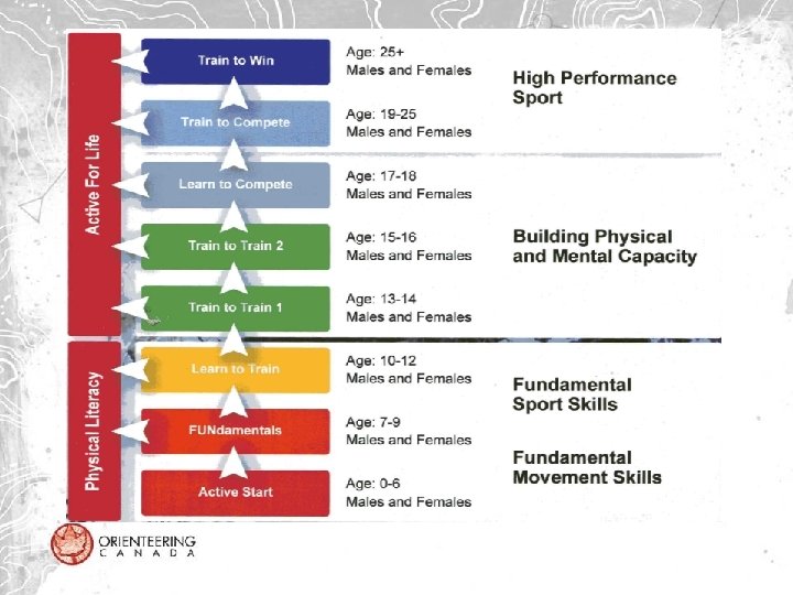
LTAD Framework for Orienteering – 9 Stages In O 100, we focus on course planning relevant to stages 1 -5 and 9
Active Start 0‐ 6 years String Course or Beginner (Course 1) - majority of navigation by an assisting adult Plan courses that § focus on skill development, fun and participation; no competitive elements § allow participants to become familiar with a map, controls and punching § use prominent features for navigation (trails, streams, large objects, boulders)
FUNdamentals 7‐ 9 years String Course or Beginner (Course 1) - some independent navigation § Plan courses that focus on participants having a fun experience in the outdoors § Children learn how the start, finish and control locations are represented on the map § Participants may be shown how to orient the map to north § Courses are planned to allow participants to relate features on the map to the physical terrain in the forest (trails, streams, fields, boulders, cliffs, buildings, fences)
Learn to Train 10 ‐ 12 years Beginner course (Course 2) - independently or with shadowing Plan your courses so that participants: § Learn how to orient the map using linear terrain features § Learn to recognize simple handrails in the terrain and how to navigate along them; be aware of handrail changes along route § Learn techniques that allow them to navigate off trails on distinct line features for short distances § Learn basic route choice tactics and decision‐making principles, e. g. , at every control, have a plan for getting to the next control
Train to Train 1 13 ‐ 14 years Beginner – Intermediate Course (Course 3) Courses should: § Follow linear features (trails, fences, streams, fields) § Make use of features slightly off the handrails § Incorporate less obvious handrails into courses, e. g. , a ridge system or a valley § Include simple route choice, e. g. , cutting directly through the forest (off‐trail) for short distances, less than 100 metres, rather than taking a longer route following a handrail
Train to Train 2 15 ‐ 16 years Intermediate course (Course 4) § Course planning can now require contour interpretation, e. g. , distinguishing up‐slopes from down; rough map reading using large contour features off‐trail; highest points in the terrain § Courses can include navigation choices involving terrain runnability differences, and use of rough compass technique for distances less than 300 m. § Ensure that course legs include reliable attack points that may require precision compass to the control
Active for Life 17 – 80+ years (Beginner, Intermediate, Advanced courses) Athletes in this stage may be competitive in Masters’ age classes or may be younger people who wish to continue orienteering at a recreational Course planning may involve the following: § Providing 1: 7500 maps to accommodate older eyes § Planning longer intermediate courses for orienteers who enjoy running but don’t have advanced orienteering skills § Reducing the climb of courses to accommodate older orienteers § Adapting course lengths/climb/technical demands to serve orienteers with a wide variety of orienteering skills and fitness s
An Integrated Development System for Orienteering Officials are a part of a system that includes parents, athletes, clubs, coaches and Orienteering Canada. As officials, you are expected to § Be knowledgeable about course planning and event organization § Have a thorough understanding of the LTAD principles for orienteering that apply to course planning § Plan courses that meet the goals of the LTAD model § Commit to supporting athletes in achieving their goals
Characteristics of Canadian Orienteering Events In Canada, there are three categories of orienteering events: • C events • B events • Canada Cup events: local, national (COC), international (NAOC)
C Events § Simplest organization. § Held over a couple of hours on a weekday evening or weekend § Most often held in an urban park for members of the local orienteering club. § One to three courses; may use one of the standard point-to-point formats (Sprint, Middle, Long) or an alternative orienteering format such as night-O, score-O, memory-O, or corridor-O.
Why are C events important? § § § Provide opportunities to acquire and maintain orienteering skills Help recruit newcomers to orienteering Provide novice and junior orienteers with non-intimidating learning experiences Provide novice officials with positive learning opportunities Combine opportunities for socializing and physical activity Clubs across Canada use a wide range of procedures and practices to run their C events. The O 100 certification aims to standardize the course planning and safety aspects of C events while allowing for regional flexibility in other aspects.
B Events § Generally one-day, weekend events held on a forest map or urban sprint map § More formal than C events. § Offer three to five courses of increasing technical and physical difficulty. § Require more volunteers than C events!
Canada Cup Events § § § Highest orienteering events in Canada (national, regional, provincial championships, or local events) Often multi-day events composed of races from all three disciplines of orienteering (Sprint, Middle, Long) Attract participants from outside the local club. Generally include a banquet, accommodation for out-of-town orienteers, assigned start times, advance registration, and promotion to orienteering community and general public. Require several key officials (event director, course planner, controller) and a large number of volunteers, including start chief, finish chief, registrar, etc. Eight (smaller Canada Cup) to eleven courses for Long and Middle distance events and six courses for Sprint events
Event Officials Orienteering events are typically organized by a team of three officials § § § Event Director Course Planner Controller
Event Director § The Event Director shall take responsibility for the event. His/her duties are defined in the appropriate Officials Manuals. § The event director is responsible for recruiting the necessary officials and volunteers and ensuring that they are all aware of their roles and responsibilities.
Course Planner § § § The Course Planner shall design the courses and arrange for appropriate event timing. If this involves electronic timing, (e. g. , SPORTident (SI)), the course planner may wish to learn to program and organize SI units, and to set up the timing system, or recruit a club member experienced in electronic timing. The Course Planner is also responsible for preparing control descriptions, control markers, and competition maps, and for correct placement of control markers and SI units/punches (if used).
Controller The Controller is responsible for the fairness of the event. The controller shall check: § the quality of the map and recommend necessary revisions § the start and finish areas and all control locations for correct position and suitability § that the general standard of the course is in accordance with current rules and standards of course planning § that the course as planned is fair to all participants, particularly with regard to the quality of map detail § that the terrain and course are safe for participants with respect to hazards and dangerous locations.
C Event Orienteering Officials § For C events, the roles of the event director and course planner are often combined § The role of a C event controller is to mentor the event director/course planner and review his/her courses. A C event controller is not required if the event director/course planner is a qualified O 100 official. § A C event controller must have at least O 200 certification.
Volunteers Required for a C Event t Role Registrar Collect fees and record names of participants Ensure membership status of all participants Start/Finish official Record starters Ensure appropriate interval between starts Record finishers Flag participants who do not report to the finish Beginner Clinics Provide basic instruction in map reading and orienteering to beginners
Volunteers All orienteering clubs in Canada rely on volunteers to donate their time and share their expertise (orienteering and other skills). It is critical that all volunteers are treated with respect. § § § Assume that all volunteers are trying their best within their area of expertise and experience Recognize and acknowledge good work Acknowledge all volunteer contributions and their importance to the success of the event Remember that volunteers have personal and professional obligations that may take precedence over their orienteering commitments Say “thank you”
Scheduling and Permissions • The date and location of C events is usually determined before the orienteering season by the local club executive or event coordinator. • Orienteering relies on the generosity of landowners to grant access to their property, including both privately and publicly owned land, such as urban parks • Some municipalities and area governing bodies do not require permission for events attended by a small number of participants • It is the club’s responsibility to be aware of these permission thresholds and to seek event permission from the landowner when required • Most clubs have a volunteer who makes any necessary permission applications
Before the Event The Event Director/Course Planner (with the assistance of the Controller) must ensure that all of the following tasks are completed well in advance of the event. Volunteers § Recruit event volunteers Plan and review courses § Obtain most recent version of the orienteering map § Select orienteering format and plan courses § Review courses with Controller and make any suggested changes § Visit the control sites to confirm that all locations are properly represented on the map and safe for participants. Make any necessary changes § Mark dangerous roads out-of-bounds § Send courses to Controller for final review
Before the Event (cont’d) Promotion § Update event information and meeting location on the club website § Distribute event information and meeting location to the club e-mail list § Promote event to non-orienteers Equipment § Obtain event equipment (flags, map bags, event box, registration sheets, event float, etc. ) Refreshments § Prepare refreshments (if provided) Print Maps § Estimate the required number of maps and have them printed. Always print some extra copies
At the Event The event director/course planner should arrive at the event site with sufficient time to complete the following tasks before participants arrive: Place Flags § Place all flags for the course § Do not hide flags. They should be easy to find if a participant is in the correct location § For night events, ensure that all flags have reflective tape § If the event area is in a high-traffic area, do not place the flags too early or they could go missing
At the Event Brief Volunteers § Ensure that volunteers understand the tasks expected of them Site Set-Up § Place signs directing participants to parking and registration § Set up registration. Ensure that the volunteers have enough waivers, membership forms, float, pens, etc. § Set up start. Ensure that the start volunteer has a timing device, the maps (clearly separated by course), a clipboard for writing down start times, etc. § Set up finish. Ensure that the finish volunteer has a timing device synched to the start timing device and a clipboard for writing down finish times § Set up refreshments if offered
Safety During the event, the event director/course planner is responsible for the safety of all participants. The event director must: § Bring the first aid kit and keep it in an easily accessible location § Know the phone numbers to contact the local fire, ambulance, police, and search and rescue services § Inform participants of potential hazards they may encounter during the event (busy roads, cyclists, slippery footing, unpleasant/dangerous flora and fauna, etc. ) § Encourage participants to wear reflective clothing at events in dark or low-visibility conditions § Ensure that participants are carrying a whistle and that they know the International Distress Signal is 3 short blasts.
Safety (cont’d) • Ensure that every participant is aware of the course closing time and that s/he must report to the finish even if s/he does not complete the course • Keep a list (the start/finish list) of all participants out on course. Check off participants as they return. • The event director shall not leave the event site until all participants have been accounted for or Search and Rescue takes over the search.
Site Set Up Example Registration Beginners’ Clinics Course Parking Refreshments Start/Finish Last Control
Registration procedures vary between clubs. Common registration functions include • • Greeting and directing new participants Collecting event and membership fees Collecting liability waivers Collecting membership forms
Beginner Instruction - Activity Discuss the following • Who should give the beginner instruction? • How long should it last? • What aspects should be covered for these new orienteers? • Would there be any difference between the information given to an adult or older teen versus a youth 10 to 13 years old?
Beginner Instruction/Coaching Most first-time orienteers require some instruction to successfully complete a course. An official should be available to give an overview to any newcomers. The beginner clinic should focus on a few basic concepts. • • The location of North on the map and in the terrain How to orient the map to the terrain The map symbols essential to completing the course What the flags look like Start, punching, and finish procedures Basic safety procedures and safety bearing Reminder to check in at the finish Course closing time After the event, be available to answer questions and review the course.
Start The start official must complete the following tasks: § § Record the full name, start time, and course of each participant Confirm that participants have the correct map and control description Remind participants of the course closing time Leave a sufficient gap (usually at least one minute) between participants starting on the same course Even if the start volunteer changes, the start location must remain the same.
Finish The finish official must complete the following tasks: § § Record finish time of each participant beside their name on the start list Calculate elapsed times during lulls in activity Direct participants to refreshments, if offered Keep track of the number of participants still on course
Timing § § § The timing at C meets is informal. For events using the SI system, participants’ times are calculated by the software. For events using pin-punches or an honour system, event officials use timing devices
Refreshments and Post-event Social • Some clubs provide post-race refreshments to participants at C events. Others promote post-race social dining. Encouraging participants to socialize after events, and allowing them opportunities to do so, helps to create relationships, foster a sense of community, and persuade newcomers to continue in the sport.
Overdue Participant - discussion A participant is overdue. From your experience, which criteria need to be considered and acted upon before calling Emergency Services for professional assistance?
Dealing with Overdue Participants At course closing time, check the finish list to see if any participants are missing. If a participant has not returned, follow the procedure below: 1. Check the start list to determine if the participant actually started and his/her start time. Determine how long the participant has been on the course. 2. Ask other participants if they have seen the missing person either on the course or at the finish. The person may have returned and not checked in to the finish. 3. Determine the location where the person was last seen. Was it early in the course or late? Did s/he appear to be lost or in trouble? What was s/he wearing? Did s/he have any food or drink? 4. Search parking areas, washrooms, and other nearby facilities. Is the person’s car still in the parking lot? Are the person’s belongings at the staging area? Are there friends or family waiting at the finish?
Dealing with Overdue Participants (cont’d) 5. Check the membership form or ask around for the person’s cell number. Call the phone. 6. Arrange for control pick-up volunteers to keep an eye out for the overdue participant. At least one volunteer must remain at the finish at all times in case the participant returns. 7. If the event is using SI and the SI number of the participant is known, the control units can be downloaded to confirm the time of each punch 8. Send an experienced orienteer with a cell phone to run the course backwards. If there are several experienced volunteers available send them to run the course forwards, to check all major trails and roads, and to drive or run the perimeter of the map, especially the area of a safety bearing. All search volunteers must have a cell phone and be experienced, competent orienteers who are unlikely to become lost themselves.
Dealing with Overdue Participants (cont’d) 9. At some point no later than 3 hours past the overdue person’s maximum allowed time, the event director must contact emergency services and ask for assistance. The decision to call in emergency services should be made by the event director and the controller, and will depend upon circumstances. Examples of factors to be considered include: § Age, health, experience of the participant § Weather conditions § Length of time the participant is overdue § Last known location of participant § Amount of daylight left § Nature of the terrain Emergency Services will become the Search Master upon arrival at the site.
Event Clean Up § § § All event flags, flagging, equipment, signage, and garbage must be collected and sorted at the end of each event Begin collecting control flags once all competitors have returned, the course-closing time has elapsed, or sufficient time has passed since the departure of the last starter that the first controls on the course are no longer in use Instruct control collectors to remove any remaining flagging tape used to pre-mark control sites Sort and dry event equipment and either return it to the club’s equipment storage or pass it along to the officials of the next event. Take care to keep stored equipment neat and organized so that future event officials will be able to find what they need quickly Remember to collect directional signs or flags that have been placed away from the primary event site Collect and dispose of any garbage at the event site so that the site is left as clean as, or cleaner than, it was before the event
Posting Results § § Calculate and post the event results on the club website or email list as soon after the event as possible Posting results can bring traffic to the club website, help keep track of event participation numbers, and allow club members to track their performance over time Budget and Finance § § Event directors should be aware of the budgetary procedures of their local club. They should submit any receipts for expenses, event monies, and necessary paperwork to the club treasurer as soon after their event as possible
Course Planning
Course Planning Terminology Control • • • A three-sided orange and white flag that identifies the checkpoint location in the terrain. Control locations are indicated on the map with red circles The flag should be placed in the centre of the control circle
Leg The section of a course between two controls
Point Feature § § A small feature that does not extend over a large area. Knolls, cup depressions, pits and boulders are all examples of point features Identify the point features.
Linear Feature § § An elongated feature, such as a fence, stream, or ridge, that continues in a constant direction for more than a couple metres A linear feature may be used as a catching feature or a handrail Identify the linear features.
Brown Dot Knoll § § A hill too small to be represented by a contour line Shown on the map as a brown dot
Re-entrant § § § A contour feature, usually located on a slope, that resembles a rising, dead-end valley A re-entrant is formed when a contour line re-enters a hill Re-entrants can be small or large
Spur § § A promontory of land jutting out from a hillside The ground slopes downward from a spur Identify spurs and re-entrants.
Handrail § § A linear feature parallel to an orienteer’s direction of travel Orienteers may follow handrails to simplify their navigation and increase their speed Identify the handrails.
Attack Point § § § A large, obvious feature near the control that is easier to locate than the control feature Participants may rough orienteer to the attack point and then precision orienteer to the flag The careful orienteering between the control and the attack point is known as attacking the control Identify an attack point for this leg.
Catching Feature § § A distinct, linear terrain feature behind a control A catching feature catches or alerts orienteers that they have travelled past the control Discuss the catching feature(s).
Characteristics of Beginner and Intermediate courses Beginner course • Beginner orienteering courses, especially those designed for children, should be planned to maximize the enjoyment and success of the participants. The course should be short, follow distinct handrails, and have no route choice. Each decision point should be marked with a control placed to lead participants in the correct direction.
Beginner course
Intermediate course § Intermediate orienteering courses introduce route choice and off-trail control locations. Technical, cross-country routes should be short, have strong attack points and/or catching features, and make use of contours and vegetation as handrails. Discuss the features of this course.
Intermediate Course
Advanced Course (for comparison only with beginner and intermediate courses)
Course Planning Theory § Plan courses that are enjoyable, challenge the full range of capabilities of the competitors, and are fair for all participants § Plan courses that reward skill and technique § Plan courses to avoid unpleasant or unsafe terrain
Terrain A well planned orienteering course uses the best terrain in an area § Terrain that includes a rich trail network, intricate contours, many manufactured or natural features, and/or a variety of vegetation can provide interesting orienteering § Terrain that has few details, thick vegetation, or is extremely steep is not desirable § On advanced courses some climb is acceptable
The Map § § § The quality of orienteering maps can vary Use areas of the map and control sites that have been mapped accurately Areas that have changed significantly since mapping, or were never properly mapped, should be avoided if possible
Control Features § § § § Create interesting legs not interesting controls Sites should be chosen based on possible routes rather than for specific features Controls must be placed on clearly defined, accurately mapped features Control sites must be recognizable both on the map and in the terrain Avoid placing controls in dense or bland areas (bingo controls) Avoid placing controls in out-of-bounds or dangerous areas Do not hide control markers. Place them so that they are fair and visible
Control features (cont’d) Orienteering should involve finding the feature, which should be larger and more visible than the flag. Once you are at the appropriate part of the feature, the control flag should be obvious.
Controls must be located on real features Control 1 is in the middle of the wall. Wall corner or wall/path junction are more specific control locations Control 2 is in the centre of a field. There is no feature to place the flag on Control 3 is on the end of a fence. This is an acceptable control location
Discuss the pros and cons of the control locations below
Course Legs An orienteering course is made up of a series of legs. § Plan legs that vary in length and direction. § Advanced courses should be made up of technical, medium legs, quick, short legs, and one or two longer, route-choice legs. § Each leg should change the participant’s primary direction of travel. § A good orienteering leads the participant through interesting, terrain, emphasizes map reading, offers route choice, and may allow for both rough and precision orienteering, depending on the of the competitors
Route Choice § Route choice (intermediate and advanced courses) can be created by planning legs that force the participant to travel across, rather than along, features in the terrain. § Short legs can be used to transport participants to the beginning of a route choice leg or to take advantage of an intricate area. § If the planned course sends participants through an area multiple times, have them approach, pass through, and leave the area at varying angles to keep the orienteering challenging.
Route Choice Exercise
Plan two Beginner courses of 5 -6 legs, on the same, or on different, maps.
Common Planning Errors Doglegs A dogleg occurs when the best route forces the participant to travel back over terrain that s/he just covered. § Doglegs are undesirable because they can be frustrating or boring for the participants and may unfairly give away the location of a control to other competitors § Legs that form an acute angle with the previous leg are often doglegs § To avoid doglegs, plan courses with angles greater than 90 degrees. A dogleg can also be created when a control is placed in a dead end § Doglegs can often be fixed by adding an extra control
Doglegs - Activity
Plan a 5 control intermediate course
Unpleasant/Unsafe Control Sites § § Controls should not be placed in difficult or unpleasant-to-access locations. Dangerous locations, such as the top of cliffs, should also be avoided
Which areas are suitable for orienteering?
Bingo Controls Bingo controls are controls that are found by luck rather than skill. § § They are placed on point features in bland or under-mapped terrain with low visibility. Participants may pass within a few metres of the control and not find it while others may stumble upon it.
Don’t Encourage Cheating On sprint maps, there are symbols that represent out-of-bounds (OOB) or uncrossable features in the terrain, such as large cliffs, high fences and walls, and some water features. Orienteers shall not cross these. § However, some features marked as out-of-bounds, such as flower beds (Control 1, below), may appear in the terrain as easily-crossable. Avoid setting legs in which an advantage is gained by participants who disobey the rules. You can sometimes flag areas that are easily crossable but OOB.
Different Course Formats A point-to-point course is a traditional orienteering course § To complete the course, participants must visit the control points in the designated order § There are many variations that can be incorporated into a point-to-point course, including control picking, butterflies, and long legs.
Point-topoint course
Control Descriptions The purpose of a Control Description is to give greater precision to the picture given by the map of the control feature and the location of the control flag in relation to the feature
Sprint, Middle, and Long courses Sprint, middle, and long distance point-to-point courses, along with relay, are the disciplines at the Canadian Orienteering Championships Sprint – a short, fast, intense race § § § Expected winning time: 12 -15 minutes Scale: 1: 4 000 or 1: 5 000 Sprint maps use a modified symbol set, ISSOM (International Sprint Specification for Orienteering Maps) Uses complex urban terrain or intricate forest Sprint course planning is characterized by short legs, many changes of direction, and complicated route choice through technical terrain
Middle § Expected winning time: 30 -35 minutes § Scale: 1: 7 500 or 1: 10 000 § Maps use the standard ISOM (International Specification for Orienteering Maps) symbol set § Middle distance courses lead participants through technical forested terrain § A middle distance course should reward precision orienteering
Long § Expected winning time: 75 -90 minutes (for elite) § Scale: 1: 15 000 for elite, 1: 10 000 or 1: 7 500 for other participants if possible § Contour interval: 2. 5 m or 5 m § Maps use standard symbol set (ISOM) § Long distance courses focus on route choice and physical endurance § A long distance course for M 21 E should have at least one route choice leg over a kilometre long
Score-O § § § Control points are scattered across the map. These controls may be visited in any order. Participants are given a pre-determined time limit and mass start. The goal is to find as many controls as possible within the time limit. Participants who return after the deadline may incur a penalty. In some score-O events, controls may have different point values depending on their difficulty and distance from the start
Course Planning Step-by-Step 1 - Choose the map Step 2 - Choose the type of course to plan Step 3 - Choose Start/Finish/parking locations Step 4 - Plan beginner course first Step 5 - Plan other courses Tip: Start planning longer courses by looking for a few long, interesting, route choice legs and plan the course around them. Step 6 - Consult with controller Step 7 - Revise Step 8 - Make a site visit to check the map and control locations Step 9 - Revise
Course Planning Software There are two computer programs that are most often used to plan basic orienteering courses: Purple Pen – http: //purplepen. golde. org/ • Purple Pen software is freeware and does not require license information. The program is intuitive and performs well for the basic planning functions needed for C event courses. Condes – http: //www. condes. net/ • Condes is the most sophisticated course planning software in use. Course planners must get the licensing information from their club.
Timing Software A number of clubs use Me. OS software for timing (Much Easier Orienteering System) • www. melin. nu/meos/en • If you choose to use meet organization and timing software for C events, enlist the help of someone in your club experienced with the software. • Remember: the event must be created and the information entered into the computer ahead of time!