OPERATIONAL SHORT AND MEDIUM RANGE FORECASTS Y V


 CUMULATIVE SUB-DIV. RAINFALL FORECAST")

")


")


 Day")
 Method of Verification:")

 Minimum Temperature (Winter season): District level weather forecast (DLWF) Maximum")


 = 6. 47% of LPA RMSE (19812013) = 6. 2% of LPA")


 for All India Seasonal Rainfall (1988 -2014): •")

 Initial conditions of")

 Forecast")


 Lead_0 Lead_2 Lead_1")
 Lead_0 Lead_2 Lead_1")
 Lead_0 Lead_2 Lead_1")
 Lead_0 Lead_2 Lead_1")

- Slides: 48
OPERATIONAL SHORT AND MEDIUM RANGE FORECASTS Y. V. Rama Rao INDIA METEOROLOGICAL DEPARTMENT
Outline • Operational NWP system at IMD for Short and Medium Range Forecasting • Generation of Customized FC Product • Major Achievements during 2014 -15 • Performance of NWP Models • New Initiatives • Future Plans
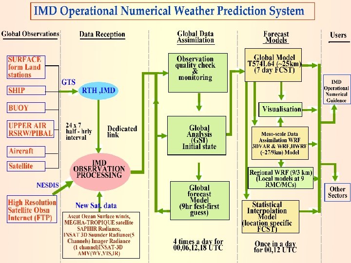
Operational NWP System Medium Range Forecast • GFS T-574/L 64 with GDAS ( 00 & 12 UTC) • MME based District Level Forecast • City Forecast for Major Cities Short Range Forecast • WRF (ARW) 3 D-VAR at 27 km and 9 km • HWRF 3 D-VAR GSI at 27/9/3 km • Aviation Products Nowcast and Very Short Range Forecast • Hourly venue specific forecast- WRF (3 km) • ARPS with assimilation of DWR • WDSS-II Nowcast System with assimilation of DWR MME Extended Range Forecast
User specific NWP products S. No. User Name Type of Forecasts 1 Agro-met Services MME based five days quantitative forecasts of rainfall, max and min temperature, cloud cover, surface humidity and winds at District Level 2 Cyclone Services HWRF, Statistical based MME Cyclone track and intensity prediction, genesis forecast 3 Aviation services WRF model based weather map of temp and wind for low flying aircrafts, meteograms 4 Hydrological services MME/WRF based gridded location specific rainfall forecasts 5 Public Weather Services 6 Day to day forecast Five days City forecast Weather forecast Data and Graphics Products Additional satellite Data: • MEGHA-TROPIQUES satellite SAPHIR Radiance (6 channel - WRF) • INSAT 3 D Sounder Radiance (5 Channels) Imager Radiance (2 Channel - WRF) • INSAT-3 D AMV (WV, MR, IR) in WRF & GFS • QC Multiple DWR data assimilation in WRF model
47 Locations
New Initiative: GFS 07 DAYS (WEEKLY) CUMULATIVE SUB-DIV. RAINFALL FORECAST
Radar Data Processing for Nowcasting Data in IRIS format DWR Data Radar Data server 512/256 Kbps VPN line HPCS mounted on NOWCAST Server -I NSSL-NETCDF format NWP models ARPS/WRF Quality controlled Radar data BUFR OPERA/NETCDF/IRIS format LAN- 100 MBPS line Radar data GTS headers LAN- 100 Mbps line LAN- 100 Mbps line NOWCAST Server –II (processing by WDSS-II) TRANSMET
WDSS-II products for Metropolitan City Forecast and Aviation forecast (Single Radar Products)
MAJOR ACHIEVEMENTS DURING 2014 -15
Major Achievements • Continuous efforts are made to update the data assimilation in GFS and WRF models by ingesting INSAT 3 D AMV in GFS and MEGHA-TROPIQUES satellite SAPHIR Radiance (6 channel) INSAT 3 D Imager (2 Channels) and Sounder (5 Channels) Radiance in WRF model. • Quality controlled multiple DWR data assimilation in WRF model started in experimental mode. • HWRF model made operational under Mo. ES-NOAA TC Project for track and intensity prediction of tropical cyclones over NIO with 5 -day lead time. Also statistical-dynamical models based MME Cyclone track, intensity prediction and genesis forecast based on GFS model provided during the cyclone situations. • Customised user specific NWP products generated for various services such as Agrometeorological, Hydrometeorological, Aviation and public weather services. • Utilization of NWP products from India and Global centres maximized for Improved Operational Weather forecast at various time scale.
Major Achievements • Improvement in Operational Cyclone Track forecast accuracy by 7. 6 km per year and intensity forecast improved by about 20 kmph in past five years and Forecast lead time increased from 3 to 5 days. • Accurate prediction of Hudhud, Nilofer and other cyclonic storms and Regionwise Severe Weather Warnings. Advances in cyclone forecasting and warning is appreciated by Prime Minister address at the 102 nd Indian Science Congress on 3 rd January, 2015. Also on the occasion of Prawasi Bhartiya Diwas (7 -9 Jan 2015) accurate cyclone forecasting is identified as one of the new order of S&T emerging from roots of Indian Knowledge. • Improved skill in operational short and medium range extreme events. Significant improvement in skill of operational forecasts and heavy rainfall warnings. • Nowcast for 130 cities using DWR data and SMS alert. Increased city Forecast to 310 cites, Tourist city Forecast from 87 to 107 destinations and validity of local forecast increased from 5 to 7 days. • District level weather forecast provided to 655 districts and block level weather forecast started experimentally for 6648 blocks. Agromet advisories through SMS and IVR technology are being disseminated to 8. 13 million farmers in the country including other modes of dissemination like TV, Radio and Print media.
Increased city Forecast to 310 cites Increased Tourist city Forecast from 87 to 107 destinations. Validity of local forecast increased from 5 to 7 days. Introduced 7 days meteorological subdivision-wise weather forecast & warnings in All India Weekly Weather Report and weekly monsoon press release during monsoon 2014
Special Forecasting Services Special forecasting services for Chardham & Hemkund sahib. Special forecast for Shri Amarnathji yatra issued and disseminated to users. Issued mesoscale weather forecast for 15 High altitude stations of Uttarakhand to all concerned state Government authorities by SMS & emails. New Infrastructure created in Dehradun
Operational tropical cyclone track forecast. Heavy rainfall warning forecast skill (%)
PERFORMANCE OF NWP MODELS
GFS All India daily mean rainfall for monitoring active/weak spell New Initiative: • Generating all India Mean rainfall along with observed normal for monitoring Weak and active spells during monsoon periods.
GFS Forecast - Monsoon-2013 Vs. 2014 Monsoon-2013 The comparison of GFS forecast during monsoon-2014 with monsoon-2013 shown, there is a significant improvement in monsoon rainfall special CC around 17% to 28% in day-4 to day-7. Similar significant reduction in RMSE in different homogeneous parts of the country except northeast India. This improvement is mainly due to the availability more observations from various new satellites.
WRF Forecast - Monsoon- 2014 The daily time series of all India rainfall in 24 hour, 48 hour and 72 hour forecasts which are plotted along with observed and normal values of Monsoon – 2014 The active i. e. the peaks in the observed field has never been missed in the model forecasts, however, the model has larger tendencies to overestimate all India rainfall merely throughout the season compared to the obsered.
OBSERVED SAPHIR INSAT-3 D + SAPHIR INSAT-3 D WRFDA Radiance Assimilation (Cyclone HUD) Day 2 FCST based on 00 UTC 09 -10 -2014
48 hour WRF Forecast 24 hour WRF Forecast CRA(Continuous Rain Area) Method of Verification: Monsoon 2014
Tropical Cyclone Track Forecast Errors IMD - MME
Rainfall (Monsoon season 2014) Minimum Temperature (Winter season): District level weather forecast (DLWF) Maximum Temperature (Pre monsoon season): • Qualitatively the model forecast for rainfall is able to predict correctly and capture the event in most of the regions of the country. Quantitatively the accuracy level varied for different regions. • Quantitatively the accuracy level still needs to be improved for some regions of the country, especially Southern (Karnataka, Kerala and Tamil Nadu) and Central India (Madhya Pradesh, Chhattisgarh and Vidarbha) as well as Jharkhand in eastern India. • Compared to rainfall forecast, the accuracy level of Temperature forecast is better for most of the States. However, Maximum Temperature forecast in Andhra Pradesh needs improvement. • There is need to improve forecast skill for fourth and fifth day. • Under the Monsoon Mission Programme, projects are undertaken by IMD for further development of comprehensive bias removal procedure.
FUTURE PLANS
Future Plans • IMD initiated using new IBM HPC facilities at IITM, Pune for operational use through NKN CUC connectivity. These resources are 100 TFlop computing (300 nodes; 4800 processors) and 600 TB disk. • GFS model (T 574/L 64) and WRF model (27/9 km) installation completed at IITM HPC from analysis to 7 -days/3 -days forecast and product generation. A parallel system to the existing NWP system at IMD, New Delhi to be established at IITM, Pune by the end of February 2015 to optimize resources utilization to provide uninterrupted NWP product delivery for real-time utilization of NWP guidance. • GFS models upgradation with En. KF (80 mem) GSI analysis, WRF with 9/3 km resolution to cover RSMC/India region to be taken up from March 2015 and Upgradation of GFS from T 574 to T 1534 compatible with NCEP modeling system to be taken up from November 2015 after validation of NCEP GFS T 1534 model outputs for Indian region during the Monsoon – 2015. • HWRF model (27/9/3 km) installed at IITM, Pune computer. Ocean coupling to HWRF was in progress in collaboration with EMC/INCOIS to make operation from premonsoon cyclone season. We are planning to Customize the for high resolution Regionalcoupled model to run for all the seasons with data assimilation, Ocean coupling including uniform verification for high impact weather.
Future Plans • Centralized Radar Data Processing for WDSS-II, ARPS and WRF model data assimilation to be implemented at IITM HPC. WDSS-II system to be made operational at remaining 9 DWR stations for Nowcast guidance. • Implementation of Physical Initialization in high resolution WRF model using DWR data for short range prediction of high impact weather and comprehensive bias removal procedure in GFS to be taken up under the Monsoon Mission Programme. • Development of High Impact Severe Weather Warning System with Mesonet Observation Test bed (Supersite) around NCR-Delhi and Eastern India (for Nor’westers) with various surface and upper air observation network including development of high resolution mesoscale model with assimilation of various observations for high impact weather forecast.
Update plans for NWP system Year Global Deterministic Regional Deterministic Cyclone Deterministic Local Deterministic 2014 (Existing) GFS- T 574/L 64 (25 km) GSI 3 D var WRF - 27/9 km 38 L 3 D-Var(12 hr) 2015 Nowcast Products 2017 GFS-T 574/64 L Hybrid En. KF (80 mem ensemble) GFS-T 1534/L 64 (13 km) Hybrid En. KF WRF-9/3 km 51 L Hybrid 3 D Var (6 hr) WRF-9/3/1 km 70 L Hybrid 4 d. Var(3 hr) HWRF - 27/9/3 km HWRF - 27/9/3 km 42 L (Ocean coupling) GSI 3 D-Var(12 hr) Hybrid En. KF (6 hr) WRF - 3 km 38 L ARPS-9 km, WDSS-II 2016 HWRF Atmospheric-Ocean coupled 9/3/1 km 70 L Hybrid En. KF (3 hr) WRF- 3/1 km 70 L WRF - 3/1 km 70 L WRF - 1 km 70 L (Semi operation) (operational) ARPS-1 km, WDSS-II ARPS-3 km, WDSS-II ARPS-1 km, WDSS-II Nowcast Products
Thank You
OPERATIONAL LONG RANGE FORECASTING D. S. Pai
Operational Long Range Forecasts Issued by ESSO-IMD Sr. No. 1 Forecast for Winter Season (Jan- March) Precipitation SW Monsoon Season (June to September) Rainfall 2 3 4 5 South-West Monsoon Onset SW Monsoon Season (June to September) Rainfall 6 SW Monsoon Monthly Rainfall for July and August SW Monsoon Second half of the Season (August- September) Rainfall September Rainfall NE Monsoon Season (October to December) Rainfall 7 8 9 Region for which forecast issued Issued in Northwest India December Country as a whole April Country as a whole June Kerala Four broad geographical regions: Northwest India, Northeast India , Central India and South Peninsula Country as a whole May June Country as a whole South Peninsula June July August September The operational forecasts are issued using statistical method 5/21/2021 30
Ensemble Forecasting System for Seasonal Rainfall over Country as a whole: S. N o Predictor Used Issued in 1 Europe Land Surface Air Temperature Anomaly (January) April 2 Equatorial Pacific Warm Water Volume (February + March) April 3 SST Gradient Between Northeast Pacific and Northwest Atlantic (December +January) April and June 4 Equatorial SE Indian Ocean SST (February) April and June 5 East Asia Mean Sea Level Pressure (February + March) April and June 6 Central Pacific (Nino 3. 4) Sea Surface Temp. Tendency (MAMDJF) June 7 North Atlantic Mean Sea Level Pressure (May) June 8 North Central Pacific Zonal Wind Gradient 850 h. Pa (May) June Schematic Diagram The average of the ensemble forecasts from best out of all possible MR (multiple regression) and PPR (projection pursuit regression) models gives the final forecast. 31 5/21/2021 31
RMSE (19812013) = 6. 47% of LPA RMSE (19812013) = 6. 2% of LPA
Skill of the statistical models currently used for the operational LRF of Monsoon Rainfall over India
Verification of Operational Long Range Forecasts for the 2014 Southwest Monsoon Rainfall Region Period All India June to September Northwest India Central India 24 th April Forecast(% of LPA) Actual Rainfall 9 th June (1 st 12 th August Update) (2 nd Update) (% of LPA) Till 28 th Sep, 2014 93 ± 4 87 ± 4 88 June to September 85 ± 8 76 ± 8 79 June to September 94 ± 8 89 ± 8 90 June to September 99 ± 8 93 ± 8 88 June to September 93 ± 8 87 ± 8 93 All India July 93 ± 9 All India August to September 96 ± 9 Northeast India South Peninsula All India 95 ± 5 90 96 ± 9 90 95 ± 8 98 The season rainfall over the country as a whole and that over four broad geographical regions (northwest India, central India, northeast India and south Peninsula) were within the limits of the forecasts updated in August and accurate. Similarly, the forecasts for the monthly rainfall (for July and August) as well as that for the rainfall during the second half of the monsoon season over the country as a whole were also accurate. 5/21/2021 34
Performance of Operational Forecast (Empirical Model) for All India Seasonal Rainfall (1988 -2014): • During 7 years error was ≥ 10% with highest during 2002 (20%) and 1994 (18%). Error during 2009 was 15%. • Average Abs Error of Op. forecasts (1988 -2014) =6. 67% (1991 -2002)= 8. 08% of LPA & 2003 -2014=6. 25% of LPA). • During 1991 -2002, the forecast was within the ± 8% of actual values during 8 years. with forecast within ± 4% of actual values during 4 years. • During 2003 -2014, the forecast was within the ± 8% of actual values during 9 years. with forecast within ± 4% of actual values during 6 years. 21 -May-21
PCR model for the Forecasting date of Monsoon onset over Kerala No Name of Predictor Period C. C(19752000) 1 Zonal Wind at 200 hpa over Indonesian Region 16 th -30 th Apr 0. 48 2 OLR Over South China Sea 16 th- 30 th. Apr 0. 40 3 Pre-Monsoon Rainfall Peak Date Pre-monsoon April-May 0. 48 4 Minimum Surface air Tem. over NW India 1 st -15 th May -0. 37 5 Zonal Wind at 925 hpa over Equatorial South Indian Ocean 1 st -15 th May 0. 52 6 OLR Over Southwest Pacific 1 st -15 th May -0. 53 Model error= 4 days The forecast issued for monsoon onset over Kerala have been within the forecast limits and accurate for all the last 10 years (since 2005 when the forecast for the event was started) Year Actual Onset Date Forecast Onset Date 2005 7 th June 10 th June 2006 26 th May 30 th May 2007 28 th May 24 th May 2008 31 st May 29 th May 2009 23 rd May 26 th May 2010 31 st May 30 th May 2011 29 th May 31 st May 2012 5 th June 1 st June 2013 1 st June 3 rd June 2014 6 th June 5 th June
ESSO- IMD’s Experimental LRF System based on Seasonal Forecast Model (SFM) Initial conditions of first 10 days of each month (NCEP reanalysis) Ø Model run for 5 months. For monsoon season - ‘ 0’ lag to ‘ 5 months’ lag IMD SFM 10 members from each IC Forecasted SST from NCEP CFSV 2 as boundary conditions (40 ensemble member from first 10 days) The model showed some useful skill for the monsoon season during hindcast mode (1982 -2011). 5/21/2021 37
Skill of ESSO- IMD SFM forecasting monthly and season rainfall over the country as a whole at different lead times: 1982 -2011 Forecast issued in JUN JUL AUG SEP JJAS AUG-SEP C. C RM SE January (CFS Jan SST) -. 07 21 -0. 01 16 0. 43 12 0. 20 22 0. 33 9 February (CFS Feb SST) 0. 06 19 -0. 01 16 0. 31 11 0. 41 18 0. 34 9 March (CFS MAR SST) 0. 04 20 0. 31 15 0. 27 14 0. 39 16 0. 50 8 April (CFS APR SST) 0 19 0. 15 15 0. 36 12 0. 41 18 0. 46 9 May (CFS MAY SST) -0. 2 21 0. 27 16 0. 09 14 0. 16 22 0. 33 9 JUN (CFS JUN SST) - - 0. 37 13 0. 05 14 0. 22 21 - JUL (CFS JUL SST) - - 0. 28 13 0. 44 18 AUG (CFS AUG SST) - - - 0. 32 19 5/21/2021 C. C RMSE 0. 35 13 0. 49 9 0. 52 10 0. 51 11 0. 29 12 - 0. 28 12 - - 0. 45 11 - -
IMD SFM Forecast For 2014 39 Forecast: All India Rainfall (% of LPA) Forecast issued in Jul Aug Sep June Sep Aug. Sep January 108 83 77 54 81 71 February 93 89 92 68 89 85 March 105 75 71 55 78 70 April 110 103 83 73 88 83 May 99 83 79 84 85 84 June - 90 106 150 - 124 July - - 97 97 - 97 Actual 58 90 91 108 88 98 5/21/2021
Other Activities: Products Based on IMD SFM in in the following link http: //www. imdpune. gov. in/climateoutlo ok/cli_index. html 1. The experimental monthly and seasonal global forecasts of temperature and rainfall for the next four months were prepared by 15 th of every month using IMD SFM model and were made available through IMD New Delhi and Pune website. 2. The monthly and season al forecasts for south Asian region were also provided through IMD, Pune website under Regional Climate Center activity. Under this activity, seasonal outlook of rainfall and temperature for south Asia were prepared uploaded in the IMD, Pune website. 3. The model forecasts were also regularly provided to ERPS group of IIT, Delhi for preparing subdivision wise monthly and seasonal forecasts.
Consensus Forecast for South Asia - 2014 Below-normal to normal rainfall is most likely during the 2014 summer monsoon season (June – September) over south Asia as a whole. Below-normal rainfall is likely over broad areas of western, central and southwestern parts of South Asia and some areas in the northeasternmost parts of the region. Normal rainfall is likely over broad areas of northwestern and eastern parts and some island areas in the southernmost parts of the region. 41 5/21/2021
Future Plans • For further improvement of forecasting system, a review of the existing operational models will be carried out and modifications will be included wherever necessary. • Preparation of skill score maps as per WMO standard verification system for IMD dynamical LRF system based on AGCM (SFM) for monthly and seasonal forecast for throughout the year. • Analysis of IITM CFSV 2 hindcast and forecasts for developing a dynamical forecasting system to generate monthly and seasonal forecast for rainfall and temperature for India and other south Asian countries throughout the 12 months of the calendar year. 42 5/21/2021
Forecast and Observed Correlation JJA
Mean Squared Skill Score (MSSS) Lead_0 Lead_2 Lead_1
Mean Squared Skill Score (MSSS 1) Lead_0 Lead_2 Lead_1
Mean Squared Skill Score (MSSS 2) Lead_0 Lead_2 Lead_1
Mean Squared Skill Score (MSSS 3) Lead_0 Lead_2 Lead_1
Thank you 5/21/2021 48