
On behalf of AsiaRi CE team Shinichi Sobue
On behalf of Asia-Ri. CE team Shin-ichi Sobue, Thuy Toan and Kei Oyoshi 1
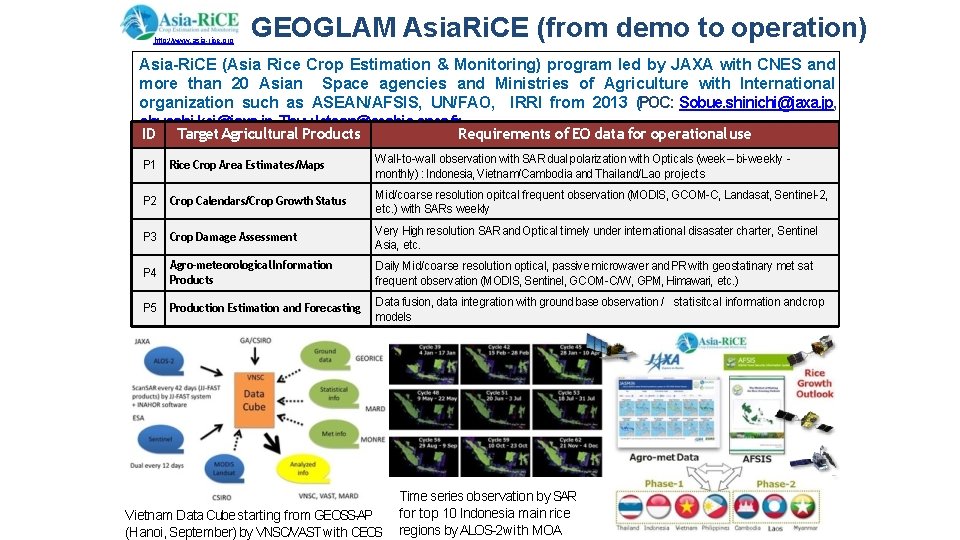
http: //www. asia-rice. org GEOGLAM Asia. Ri. CE (from demo to operation) Asia-Ri. CE (Asia Rice Crop Estimation & Monitoring) program led by JAXA with CNES and more than 20 Asian Space agencies and Ministries of Agriculture with International organization such as ASEAN/AFSIS, UN/FAO, IRRI from 2013 (POC: Sobue. shinichi@jaxa. jp, ohyoshi. kei@jaxa. jp, Thuy. letoan@cesbio. cnes. fr ID Target Agricultural Products Requirements of EO data for operational use P 1 Rice Crop Area Estimates/Maps Wall-to-wall observation with SAR dual polarization with Opticals (week – bi-weekly monthly) : Indonesia, Vietnam/Cambodia and Thailand/Lao projects P 2 Crop Calendars/Crop Growth Status Mid/coarse resolution opitcal frequent observation (MODIS, GCOM-C, Landasat, Sentinel-2, etc. ) with SARs weekly P 3 Crop Damage Assessment Very High resolution SAR and Optical timely under international disasater charter, Sentinel Asia, etc. P 4 Agro-meteorological Information Products Daily Mid/coarse resolution optical, passive microwaver and PR with geostatinary met sat frequent observation (MODIS, Sentinel, GCOM-C/W, GPM, Himawari, etc. ) P 5 Production Estimation and Forecasting Data fusion, data integration with ground base observation / statisitcal information and crop models Vietnam Data Cube starting from GEOSS-AP (Hanoi, September) by VNSC/VAST with CEOS Time series observation by SAR for top 10 Indonesia main rice regions by ALOS-2 with MOA
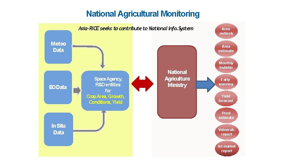
National Agricultural Monitoring Asia-RICE seeks to contribute to National Info. System Meteo Data EO Data Area outlook Area estimate Space Agency, R&D entities for Crop Area, Growth, Conditions, Yield National Agriculture Ministry Monthly bulletin Early warning Yield forecast Prod estimate In Situ Data Vulnerab. report Int market report
Report from TG 5: Asia-RICE and Food Security GEOGLAM 26 October, 2018 The participants represent different communities: researchers on earth observations or decision-support systems, and national and international users whose targets are operational implementations. Insightful interactions between participants have led to mutual learning about the present status, challenges and opportunities of what can be achieved. The TGsession comprises three parts: 1) Rice monitoring through satellite and ground-level observations, 2) Rice monitoring for regional food security and environment, and 3) Rice crop Outlook activities and crop yield estimation model. The discussion focused on the actions to be undertaken on each of the GEO priority areas with the following outcomes:
TG 5: Asia-RICE and Food Security 1. Sustainable Development Goals It is critical to end poverty and hunger: Asia. Ri. CE directly addresses the issues of SDGs 1 and 2, but also SDG 3, 6, 10, 13, 15 and 17. It will be through better agri-food policy implementation. Compiled agromet information from various EOsystems in Japan (JAXA/JASMIN), India (ISRO/MOSDAC) and other Asia. RICE countries under GEOGLAM. Asia. Ri. CE will greatly contribute to global and regional food security, by improving the outlook of crop production, precision agriculture, development of decision-support systems and early warning systems for biotic and abiotic stresses, in cooperation with the ASEANFood Security Information System (AFSIS). 2. Paris Climate Agreement The lowland rice field is one of the major sources of methane emission, a key component of greenhouse gas. Methane being measured and modelled by Asia. Ri. CE for optimization and minimization of water use and for reducing the methane emission without sacrificing the rice production.
TG 5: Asia-RICE and Food Security 3. Sendai framework for the Disaster risk Reduction For risk management of water-related disasters, it is important to understand the impact of drought and flood on agriculture, which can be estimated by the agromet information and the monitoring of inundated area based on EOdata in the activities of Asia. Ri. CE. This task is closely linked with SDG 13. 4. Emerging case of the Mekong River basin Asia. Ri. CE and Data Platforms will work with Vietnam National Space Center and Mekong river Commission to develop Open Data Cube deployments across the Mekong region with a focus on rice crop and forest monitoring in addition to hydrological response. Data sharing and data platforms/cubes are planned in the 2019 workplan by development of Analysis Ready Data, capacity building, and integration of systems for the Mekong region.
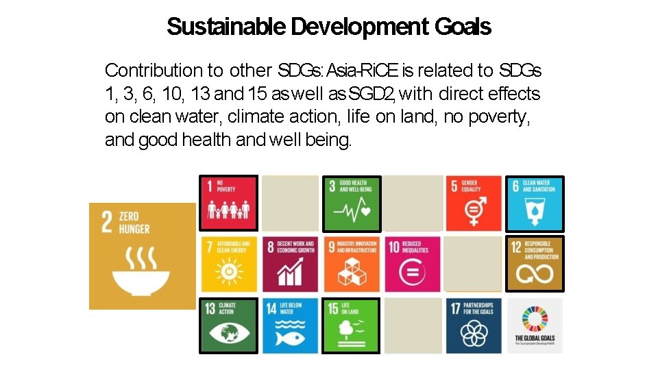
Sustainable Development Goals Contribution to other SDGs: Asia-Ri. CE is related to SDGs 1, 3, 6, 10, 13 and 15 as well as SGD 2, with direct effects on clean water, climate action, life on land, no poverty, and good health and well being.
Asia-Ri. CE highlights Research and Development Activities 1. 2. Demonstration at Technical demonstration sites (TDS) (India, Japan, Malaysia, Philippine Thailand , Tiwan (Chinese Taipei), Cambodia and Myanmar from 2016). Demonstration at Regional/National scale: wall-to-wall Vietnam , and top 10 rice production provinces in Indonesia • • • APRSAF(Asia Pacific Regional Space Agency Forum) SAFEiniative with ALOS-2 and Inahor: Cambodia, Indonesia, Myanmar and Vietnam (Mekong) ESA-GEORICEusing Sentinel-1 for Vietnam ADB project using ALOS-2 (with Inahor) for Lao, Philippine, Thailand Vietnam (Red river) 3. On going research using SARs(L/X/C ) and optical (S 2/Landsat/Venus/Formosat) for Rice Yield estimate and Methane Emission at TDSand JECAMsite(s) Towards operational services 1. 2. Start to set up pre-operational service for rice crop growing monitoring using ALOS-2 Scan. SAR and Sentinel-1 and other satellites in Indonesia and Vietnam For Vietnam, under the cooperation with CSIRO, GA and VNSC, JAXA integrates ALOS-2 Scan. SAR data, and CNES-CESBIO integrates Sentinel-1 SAR ARD to CEOSVietnam Data Cube for rice monitoring.
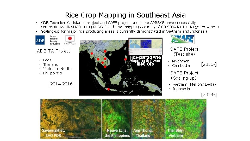
Rice Crop Mapping in Southeast Asia ADB Technical Assistance project and SAFE project under the APRSAF have successfully demonstrated INAHOR using ALOS-2 with the mapping accuracy of 80 -90% for the target provinces Scaling-up for major rice producing areas is currently demonstrated in Vietnam and Indonesia. • • ADB TA Project • • Laos Thailand Vietnam (North) Philippines [2014 -2016] Rice-planted Area Mapping Software (INAHOR) SAFE Project (Test site) • Myanmar • Cambodia [2016 -] SAFE Project (Scaling-up) • Vietnam (Mekong Delta) • Indonesia [2014 -] 9
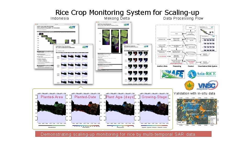
Rice Crop Monitoring System for Scaling-up Indonesia Planted Area Mekong Delta Planted Date Plant Age (days) Data Processing Flow Growing Stage Validation with in-situ data Demonstrating scaling-up monitoring for rice by multi-temporal S A R data.
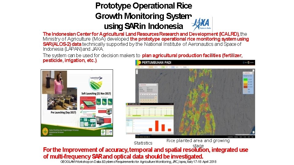
Prototype Operational Rice Growth Monitoring System using SARin Indonesia The Indonesian Center for Agricultural Land Resources Research and Development (ICALRD), the Ministry of Agriculture (Mo. A) developed the prototype operational rice monitoring system using SAR(ALOS-2) data technically supported by the National Institute of Aeronautics and Space of Indonesia (LAPAN) and JAXA. The system can be used for decision makers to plan agricultural production facilities (fertilizer, pesticide, irrigation, etc. ). Statistics Rice planted area and growing stage For the Improvement of accuracy, temporal and spatial resolution, integrated use of multi-frequency SARand optical data should be investigated. GEOGLAM Workshop on Data &Systems Requirements for Agriculture Monitoring, JRC, Ispra, Italy 17 -18 April 2018
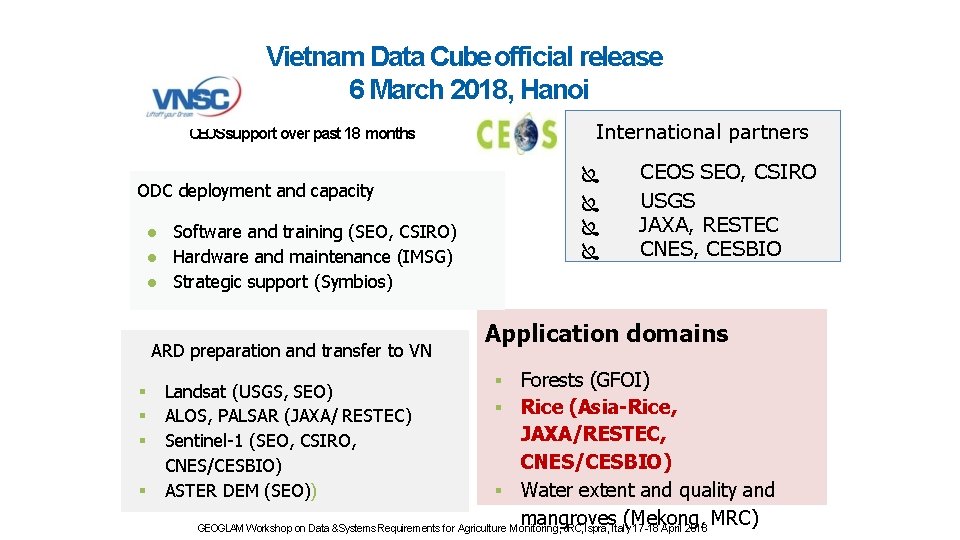
Vietnam Data Cube official release 6 March 2018, Hanoi International partners CEOSsupport over past 18 months ODC deployment and capacity ● Software and training (SEO, CSIRO) ● Hardware and maintenance (IMSG) ● Strategic support (Symbios) ARD preparation and transfer to VN CEOS SEO, CSIRO USGS JAXA, RESTEC CNES, CESBIO Application domains Forests (GFOI) Rice (Asia-Rice, JAXA/RESTEC, CNES/CESBIO) Water extent and quality and mangroves (Mekong, MRC) GEOGLAM Workshop on Data &Systems Requirements for Agriculture Monitoring, JRC, Ispra, Italy 17 -18 April 2018 Landsat (USGS, SEO) ALOS, PALSAR (JAXA/ RESTEC) Sentinel-1 (SEO, CSIRO, CNES/CESBIO) ASTER DEM (SEO))
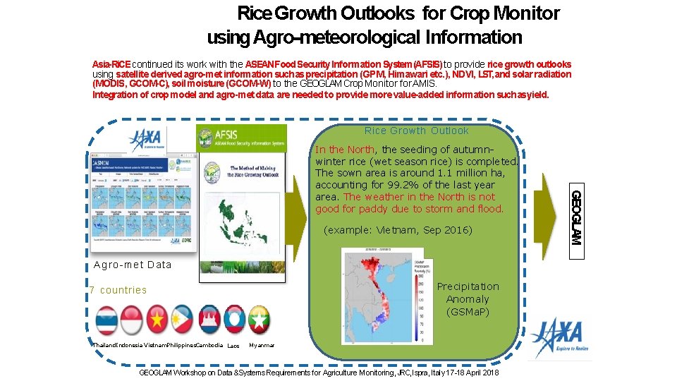
Rice Growth Outlooks for Crop Monitor using Agro-meteorological Information Asia-Ri. CE continued its work with the ASEANFood Security Information System (AFSIS) to provide rice growth outlooks using satellite derived agro-met information such as precipitation (GPM, Himawari etc. ), NDVI, LST, and solar radiation (MODIS, GCOM-C), soil moisture (GCOM-W) to the GEOGLAM Crop Monitor for AMIS. Integration of crop model and agro-met data are needed to provide more value-added information such asyield. Rice Growth Outlook (example: Vietnam, Sep 2016) Agro-met Data Precipitation Anomaly (GSMa. P) 7 countries Thailand Indonesia Vietnam. Philippines. Cambodia Laos Myanmar GEOGLAM Workshop on Data &Systems Requirements for Agriculture Monitoring, JRC, Ispra, Italy 17 -18 April 2018 GEOGLAM In the North, the seeding of autumnwinter rice (wet season rice) is completed. The sown area is around 1. 1 million ha, accounting for 99. 2% of the last year area. The weather in the North is not good for paddy due to storm and flood.
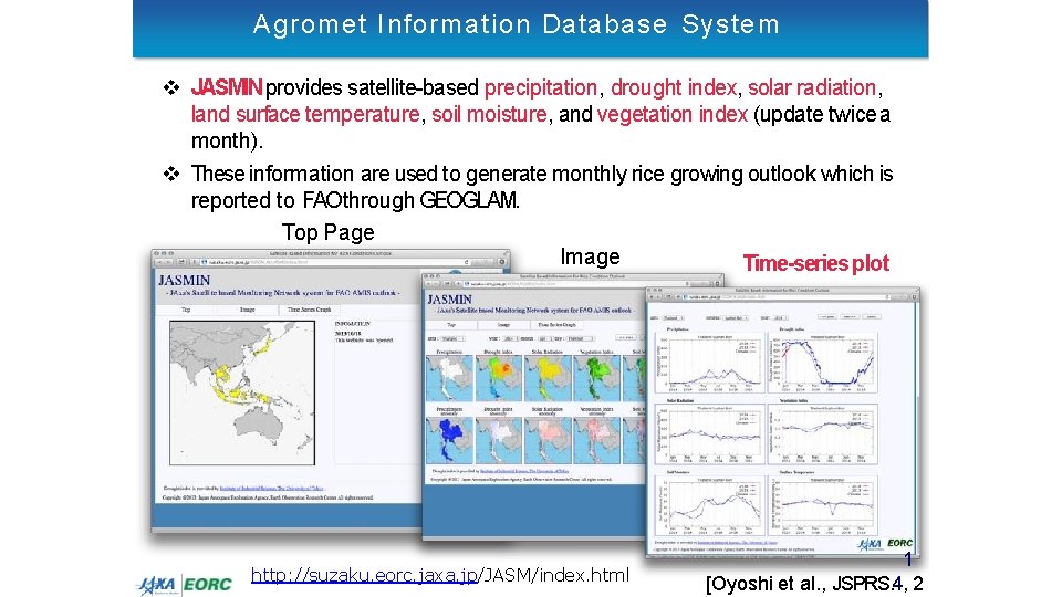
Agromet Information Database System JASMIN provides satellite-based precipitation, drought index, solar radiation, land surface temperature, soil moisture, and vegetation index (update twice a month). These information are used to generate monthly rice growing outlook which is reported to FAO through GEOGLAM. Top Page Image Time-series plot http: //suzaku. eorc. jaxa. jp/JASM/index. html 1 [Oyoshi et al. , JSPRS. 4, 2
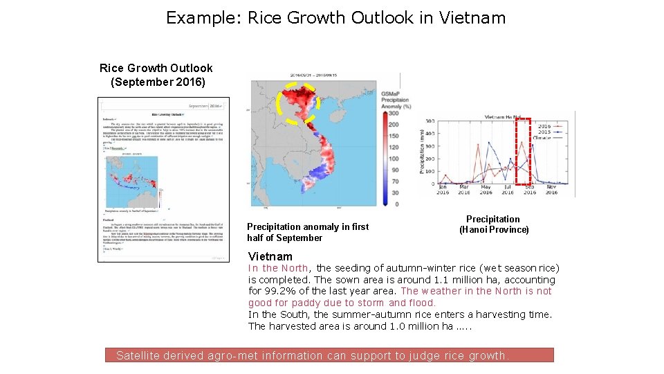
Example: Rice Growth Outlook in Vietnam Rice Growth Outlook (September 2016) Precipitation anomaly in first half of September Precipitation (Hanoi Province) Vietnam I n the North, the seeding of autumn-winter rice (wet season rice) is completed. The sown area is around 1. 1 million ha, accounting for 99. 2% of the last year area. The weather in the North is not good for paddy due to storm and flood. In the South, the summer-autumn rice enters a harvesting time. The harvested area is around 1. 0 million ha …. . Satellite derived agro-met information can support to judge rice growth.
Asia-Ri. CE next step as phase 3 • • • Promote wall-to-wall rice crop monitoring with EO data through in situ data validation in cooperation with GEORICE, data cube, etc. together with Asia Rice team members and international donors Promote outcome / output application/research results and progress at international conference such as Living Planet Symposium, IGARSS, ACRS, etc. Promote the Open data cube in Vietnam, Cambodia, Chinese Taipei in cooperation with VNSC, GA, ESA/CNES, NSPO and JAXA Continue to promote rice crop outlook in Asia with the agro-met information from Japan (JASMIN) and India (MOSDAC) Conduct Research on • Time series SAR and Optical data to create ARD to Open data cube for rice crop monitoring. • Rice crop model for yield estimation • Methane emission from paddy field Standardize field survey for validation in national and regional scale (request to team member cooperation to do this with GEORICE) Promote data cube and other cloud base system with available data sources and tools (INAHOR and GEORICE) Research on the practicality and potential integration of operational system like as FASAL/India Capacity building with Asia in cooperation with available training centres such as ARTSA, IIRS, CSSTEAP Coming Events • APRSAF space application working group and SAFE workshop, 5 -7 November – Singapore • ISPRS-GEOGLAM workshop in Delhi on Earth Observation for Agricultural Monitoring during Feb 18 -20 India
- Slides: 16