Oceans Basins The Ocean Bathymetry study of underwater

Oceans Basins

► The Ocean Bathymetry study of underwater depth and ocean floor. ► In the same way that topographic maps represent the three-dimensional features of overland terrain, bathymetric maps illustrate the land that lies underwater. ► Variations in sea-floor relief may be depicted by color and contour lines called depth contours or isobaths.

Measuring Bathymetry Modern Acoustic Instruments ► Side scan sonar ► Towed behind ship. Provides a detailed bathymetric map. © 2011 Pearson Education, Inc.

© 2011 Pearson Education, Inc.

► Side-scan sonar is used to create an image of large areas of the sea floor. ► This tool is used for mapping the seabed in conjunction with seafloor samples it is able to show differences in material and texture type of the seabed.

Side Scanning Sonar © 2011 Pearson Education, Inc.

© 2011 Pearson Education, Inc.

Draining the Ocean ► https: //www. youtube. com/watch? v=HVJNL Sw. CGHc

Main Features

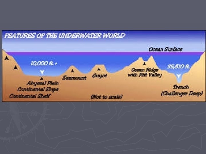
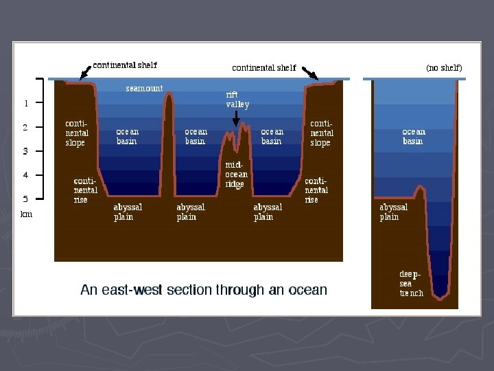
Ocean Areas Three Major Areas ► Continental Margins: § Shallow areas close to shore, includes: Continental Shelf, Continental Slope and Continental Rise. ► Deep-ocean basins § Deep areas farther from land; includes Abyssal plains and oceanic ridges ► Others: § Trenches, Seamounts and Guyots, Atolls © 2011 Pearson Education, Inc.

Continental Areas ► Non-Active § Not close to plate boundaries § No major tectonic activity § Example: East coast of Canada ► Active § Associated with convergent or transform plate boundaries § Much tectonic activity

Passive and Active Continental Margins

Instructions: ► Activity 1: § In groups of 3 or 4, look at the images provided. § Discuss the highlighted features for each image. § Using the characteristics and terms provided, match the image with the characteristics and terms. ► Activity 2: § On the sheet provided, label the diagram § Make sure you have definitions for all of the terms!

Major Sea Floor Structures: B. Continental Slope D. Mid Ocean Ridge C. Sea Mount I. Abyssal Plain E. Island F. Continental Shelf H. Oceanic Trench J. Rift G. Guyot

Definitions ► Continental Shelf – Almost flat gradual slope seaward at the edges of the continent ► This is very wide off of Canada’s maritime provinces. (Grand Banks and Scotian Shelf)

► Continental Slope – steeper slope seaward; ► Continental Rise: shallower slope contains submarine canyons composed of sediments that have fallen from slope ► Abyssal Plain – The largest portion of the earth’s sea bed. Vast, empty and usually boring.

Seamounts and Guyots Both are undersea volcanoes that originated at a hotspot or along a ridge Guyots once reached the surface of the ocean and have flat, eroded tops Seamounts never reached the surface, so they have pointy tops

Example: Hawaii!

Submarine Canyons ► V-shaped indentations in the continental shelf, usually ending in a fan shaped wedge of sediments. How do submarine canyons form? ► Thought to be fast moving currents and underwater landslides.

The Gully! Submarine canyon off Nova Scotia ► Marine Protected Area because of the rare corals found there ► The natural gas pipeline goes right by it…problems? ► The Gully

Mid-Ocean Ridge ►A large underwater mountain chain. ► Part of a cast system extending some 40, 000 miles through four of the world’s oceans ► Caused by divergent plate boundaries

Mid-Ocean Ridge © 2011 Pearson Education, Inc.

© 2011 Pearson Education, Inc.

Mid-Ocean Ridge Features Seamount Pillow lava © 2011 Pearson Education, Inc.

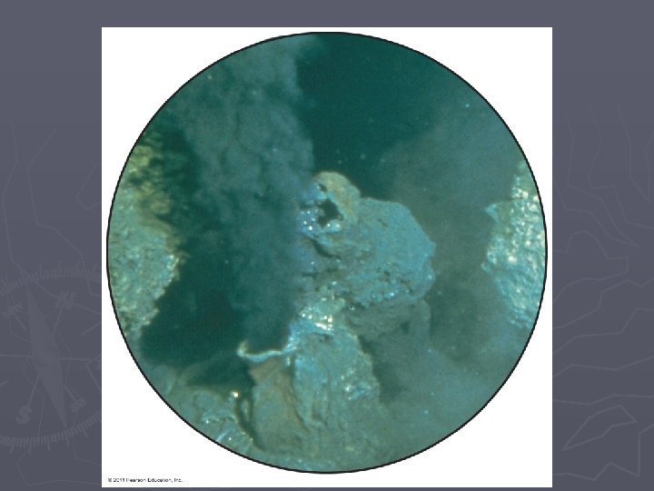
Mid-ocean Ridge Features Hydrothermal Vents ► Sea floor hot springs ► Create ecosystems able to survive without sunlight ► https: //www. youtube. com/watch? v=D 69 h. Gv. Cs. Wg. A © 2011 Pearson Education, Inc.

Hydrothermal Vents © 2011 Pearson Education, Inc.

Ocean Trenches and Volcanic Arcs ► Convergent trenches. tectonic plates create ocean § Deepest part of oceans § Deepest – Mariana Trench at 11, 022 meters (36, 161 feet) ► Volcanic arc on non subducted ocean plate § May produce island arc, Japan ► Island Arc – A series of islands of volcanic origin, usually found at or near the edge of an ocean © 2011 Pearson Education, Inc. basin.

Atolls ► A ring shaped island of coral reefs and coral debris. These often form over sinking inactive volcanoes.

Where atolls? ► Most of the world's atolls are in the Pacific Ocean and Indian Ocean ► The Atlantic Ocean has no large groups of atolls other than eight atolls east of Nicaragua

Atlantic Topography Map ► Complete Activity. the Atlantic Topography Map
- Slides: 33