Oceania Oceania The Pacific Islands or Oceania contains


 arc off the northern")


- Slides: 17
Oceania
Oceania • The Pacific Islands or Oceania contains more than 25, 000 islands and islets of 25 nations and territories across the Pacific Islands • Although the Pacific Islands are scattered across millions of square kilometers, their total land area is just 1, 261, 456 sq km (487, 051 sq mi) • - slightly larger than South Africa, slightly smaller than Peru, and four-fifths the size of Alaska.
Oceania Continued • The islands of New Guinea, New Zealand, and Hawaii cover 93 percent of the land area – The remaining thousands of islands cover 34, 494 sq mi – Less than the American state of Indiana. • New Guinea, and the Indonesian province of Irian Jaya is the second largest island in the world – 1 st is Greenland • New Zealand’s South Island North Island, Oceania’s next largest islands, are the world’s 12 th and 14 th largest islands, respectively.
Melanesia, Micronesia and Polynesia • The Pacific Islands are usually divided into three sub regions: • 1. Melanesia (the prefix mela, meaning dark or black, refers to the dark complexion of many Melanesian people) • 2. Micronesia (the prefix micro, meaning small, refers to the small size of Micronesia’s islands and atolls) • 3. Polynesia (the prefix poly, meaning many, refers to the many islands of Polynesia).
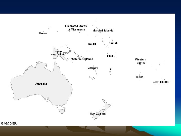
Melanesia • Melanesia stretches in a 5600 -km (3500 -mi) arc off the northern and eastern coast of Australia. • From northwest to southeast, Melanesia includes: • 1. New Guinea, lying just north of Australia; • 2. The Bismarck Archipelago, belonging to Papua New Guinea • 3. Smaller archipelagos of Papua New Guinea • 4. The Solomon Islands • 5. The many islands of the nation Vanuatu • 6. The Fiji Islands (an island nation commonly known as Fiji).
Micronesia • Micronesia has five main island groups. • 1. The Caroline Islands lie north of the equator from New Guinea and belong mostly to the Federated States of Micronesia, a self-governing country in free association with the United States. • 2. The Mariana Islands, which make up the Commonwealth of the Northern Mariana Islands, a self-governing U. S. commonwealth • 3. Guam, an unincorporated U. S. territory. • 4. The Marshall Islands, an island group and republic in free association with the United States. • 5. The nation of Kiribati, which straddles the equator. The tiny nation of Nauru, a single island west of Kiribati, is also counted as part of Micronesia.
Polynesia • Polynesia is larger than both Melanesia and Micronesia combined. • The southwestern tip of the Polynesian triangle is the nation of New Zealand, lying southeast of Australia and far south of the tropic of Capricorn. • The southeastern tip is Easter Island, part of Chile lying just south of the tropic of Capricorn three-fourths of the distance from Australia to South America. • The triangle’s northwestern tip is Hawaii, straddling the tropic of Cancer halfway between North America and Asia. • These three tips, however, are outliers: Most of Polynesia is clustered just east of Melanesia south of the equator. • Farther east lie the five archipelagos of the French territory French Polynesia
What about Australia? • Oceania is sometimes defined to include Australia, but because of Australia’s continental size and its distinct geography, climate, and cultures it is more often considered a separate region of the world. • Similarly, the Philippine, Indonesian, and Japanese archipelagos, which border Melanesia and Micronesia, bear a greater resemblance to the rest of Asia than the Pacific Islands do. • We will study these areas as part of this unit but keep in mind they are considered separate geographically
The Natural Environment of Oceania • The islands of the Pacific are often classified according to their altitudes as high or low islands. • High islands are further classified as either – 1. continental – 2. oceanic. • The continental high islands were once part of the eastern edge of the Australian and Asian continents and are composed of metamorphic rocks • Continental islands include New Guinea and most islands of Melanesia, which together account for more than three-fourths of Oceania’s land area.
Oceanic High lands • The oceanic high islands, sometimes called volcanic islands, are divided from the continental high islands • The oceanic islands are composed of volcanic materials. (similar to sea floor spreading) • The islands, then, are merely the tops of undersea mountains. • Typically, the mountains (and islands) extend in curving chains. • These high oceanic islands are common in Polynesia and Micronesia. • The island of Hawaii, contains the peaks Mauna Loa and Mauna Kea, which are considered the world’s largest mountains
Low Islands • Like the high islands, low islands are also further classified into two subgroups: • 1. eroded volcanic islands • 2. Atolls. • The eroded volcanic islands are much like the oceanic, or volcanic, high islands, only they have been eroded to such a point that they are barely above sea level. • Examples of these islands include the smaller, lower islands of Hawaii.
Atolls • Atolls are a series of islands that form a rough ring enclosing a central body of water called a lagoon. • The various islets of the ring are called motus and are separated by sea channels that lead into the lagoon. • An atoll is continually built upward from an underlying coral reef, itself formed from the skeleton of a tiny, lime-secreting animal called a polyp. • Typically, some parts of an atoll are above sea level while other parts remain below.
Climate • Most of Oceania has a humid subtropical • These areas have a similar climates • Temperatures typically average close to 27° C (80° F) most of the year. • In the area from about 30° north of the equator to about 30° south of the equator, the westwardmoving trade winds prevail. • These steady winds carried the sailing vessels of European traders • Where the northern and southern trade winds meet near the equator they cancel each other out, creating the doldrums, a region of little or no wind more formally called the Intertropical Convergence Zone (ITCZ).
Soils and Vegetation • The vegetation of the Pacific Islands varies by island type. The continental islands have vegetation typical of tropical climates: – 1. Mangrove forests rim the island. – 2. The interior is typically rain forest or monsoon forest. • Higher elevations have temperate forests, including pine trees. • Some areas of continental islands have fertile soil • Soils on coral atolls are thin, sandy, and much less fertile. • Vegetation consists of shrubs, small trees, grasses, and the very common coconut palm. • However, on low islands that receive heavier rainfall, some forests exist.
The People of the Pacific Islands • Many different ethnic groups make up the people of the Pacific Islands – Reflects various migrants to the area over several thousand years. • These peoples can be traced to Southeast Asia; Europeans and Americans; Chinese; and Indians, found mostly in Fiji. • More recent immigrants include Vietnamese to New Caledonia and Vanuatu, and Filipinos to Micronesia
Population • The entire Pop of Oceania is 35. 7 Million, but Australia is over 22 million • Oceania – Australia is 13. 6 Million people • Papua New Guinea is the most populated of the Island Nations (5. 1 million) – Coral sea Island (4) and Wake Islands (12) are both small and have a tiny population