Ocean Currents Early ocean studies For much of


 • Franklin served as colonial deputy postmaster general from 1753")
 • The American Naval officer conducted the first systematic")

 is in the deep ocean, isolated from")


- Slides: 40
Ocean Currents
Early ocean studies • For much of human history, knowledge of the ocean and its currents was not recorded for many reasons most sailors could not write and information was passed orally. • European nations began systematic ocean explorations but kept information secret between the 15 th 18 th centuries. • The Gulf Stream, was known as early as 1519. • Bishop Resen of Copenhagen drew the first map of the Gulf Stream in 1605 – his map was based on records from trans Atlantic voyages of explorer Martin Frobisher (1535 1594). Subsequent charts were published in 1678 by Athanasius Kircher and 1685 by Happelius.
Benjamin Franklin (1706 1790) • Franklin served as colonial deputy postmaster general from 1753 1774. • He found that British merchant ships arriving in the colonies from England took many days to weeks longer to make the voyage than American vessels. • Franklin’s cousin Timothy Folger, a whaling ship captain told him of the Gulf Stream, the strongest surface current in the North Atlantic (10 12 km/hr or 6 7 miles/hr) • Franklin published his cousin’s chart showing the location of the Gulf Stream and presented it to the British.
Matthew Fontaine Maury (1806 1873) • The American Naval officer conducted the first systematic study of the ocean’s surface currents and winds. • Maury compiled information on currents and winds from logbooks of sailors’ observations stored at the US Navy’s Depot of Charts and Instruments. • He estimated current directions and speeds by analyzing deflections in ships courses caused by surface ocean currents. Combining thousands of observations, Maury constructed a map of average surface currents.
Causes of Surface Ocean Currents • Energy and matter are continually exchanged between the ocean and atmosphere and these processes drive ocean circulation. • Evaporation, precipitation, heating and cooling bring about changes in temperature and salinity of surface waters. Density changes that accompany changes in temperature and salinity can cause water to sink or rise in the ocean. • Kinetic energy is transferred from near surface winds to the ocean’s surface layer, driving the currents of the upper few hundred meters of the ocean. Winds are responsible for horizontal and vertical water motions within the surface layer.
Deep Ocean Currents • Most water (90%) is in the deep ocean, isolated from the atmosphere and its winds. • Differences in water density drive the sluggish circulation of deep water these waters flow at speeds less than 1 cm/s (1 km/day) – about 240 times slower than the Gulf Stream. • Because of its volume and isolation from the atmosphere, the deep ocean is both a storehouse for heat (acting as a global buffer for temperature change) and a reservoir for gases such as carbon dioxide that remain there for centuries to millenia.
Circulation Patterns • The ocean features two different circulation patterns: – Wind driven surface ocean currents – deep ocean’s slower density driven thermohaline circulation
Ocean’s Vertical Structure • Except at high latitudes, the ocean is divided into three horizontal depth zones based on density: – – The mixed layer Pycnocline The deep layer At high latitudes, the pycnocline and mixed layers are absent
Mixed Layer: Wind driven surface currents • Restricted to the ocean’s uppermost 100 m (300 ft) or less • Strongest currents occur in surface layer (although some surface currents such as boundary currents like the Gulf Stream can be strong to depths of several hundred meters). • Changeable, continually responding to variations in wind, precipitation, heating and cooling • Stirring of surface waters by the wind produces a well mixed layer of nearly uniform density. For this reason, the surface ocean is called the mixed layer.
Pycnocline • Pycnocline: Situated between the mixed layer and deep layer, where water density increased rapidly with depth because of changes in temperature and/or salinity. • Cold water is denser than warm water and salty water is denser than fresh water. • Thermocline: decrease in density with depth. • Halocline: increasing salinity with increasing depth. • Typically, the pycnocline extends to a depth of 500 1000 m.
Deep Layer • Accounts for most of ocean’s mass. • Within the deep layer, density increases gradually with depth and water moves sluggishly. • In only a few locations (usually near the bottom) are water movements fast enouh to be considered currents.
Stability • The ocean’s 3 layer structure is separated by gravity, dense fluids sink, less dense fluids rise. • The ocean’s pycnocline is very stable thus suppressing mixing between the mixed layer and deep layer. • Stability refers to vertical motions of the ocean – a system is stable if it tends to persist in its original state without changing. • Strong storms may disturb the stable stratification bringing colder water to the surface, once the winds slacken, the original layered structure returns. • Unstable systems (perturbations in salinity, temp, density) will always shift toward a more stable density distribution.
Wind driven currents and Ekman Transport • The wind blows across the ocean and moves its waters as a result of its frictional drag on the surface. Waves cause the surface roughness necessary for the wind to couple with surface waters. • A wind blowing steadily over deep water for 12 hours at an average speed of 100 cm/s (2. 2 mi/hr) would produce a 2 cm/s current (about 2% of the wind speed). • If Earth did not rotate, frictional coupling between moving air and ocean would push a thin layer in the same direction as the wind. The surface layer would drag the layer beneath it and continue to propagate downward.
Review of Coriolis • If Earth did not rotate, surface winds would blow directly from the poles (high pressure) to the equator (low pressure). • Because the Earth rotates, anything moving freely (air and water) is deflected clockwise in the Northern Hemisphere and counterclockwise in the Southern Hemisphere. This deflection is the Coriolis effect.
Coriolis is at a maximum at the poles Clockwise defelction The Coriolis Effect is Zero at the equator Counterclockwise deflection
• • • Using vectors to plot the direction and speed of water layers at successive depths, we can show a simplified three dimensional current pattern caused by a steady horizontal wind. This model is known as the Ekman spiral, named for the Swedish physicist V Walfrid Ekman (1874 1954) who first described it mathematically in 1905. Ekman based his model on observations made by the Norwegian explorer Fridtjof Nansen (1861 1930). Nansen was interested in ocean currents in polar seas. In 1893, he allowed his 39 m (128 ft) wooden ship, the Fram, to freeze into Arctic pack ice about 1100 km (680 mi) south of the North Pole. His goal was to drift with the ice and cross the North Pole thereby determining how ocean currents affect the movement of pack ice. The Fram remained locked in pack ice for 35 months but only came within 394 km (244 mi) of the North Pole. As the Fram slowly drifted with the ice, Nansen noticed that the direction of ice and ship movement was consistently 20 to 40 degrees to the right of the prevailing wind direction.
Ekman Spiral Continued • • The Ekman spiral indicates that each moving layer is deflected to the right of the overlying layer's movement. The direction of water movement changes with increasing depth. In an ideal case, a steady wind blowing across an ocean of unlimited depth and extent causes surface waters to move at an angle of 45 degrees to the right of the wind in the Northern Hemisphere (45 degrees to the left in the Southern Hemisphere). Each successive layer moves more toward the right (CW) and at a slower speed. At a depth of about 100 to 150 m (330 to 500 ft), the Ekman spiral has gone through less than half a turn. Yet water moves so slowly (about 4% of the surface current) in a direction opposite that of the wind that this depth is considered to be the lower limit of the wind's influence on ocean movement.
Ekman Spiral – water movement • In the Northern Hemisphere, the Ekman spiral predicts net water movement through a depth of about 100 150 m (330 500 ft) at 90 degrees to the right (clockwise) of the wind direction. • Southern Hemisphere is counterclockwise (left) • This net transport of water due to coupling between air and water is called the Ekman transport • The real ocean does not match the idealized conditions of Ekman spiral, wind induced water movements often differ appreciably from theoretical predictions. • In shallow water, the water depth is insufficient for the full spiral to develop so movements can be as little as 15 degrees. • As water deepens, the angle increases and approaches 45 degrees. • The stable pycnocline inhibits the transfer of kinetic energy. • Ekman transport piles up surface water in some areas of the ocean and removes waters from other areas, producing variations in the height of the sea surface, causing it to slope gradually.
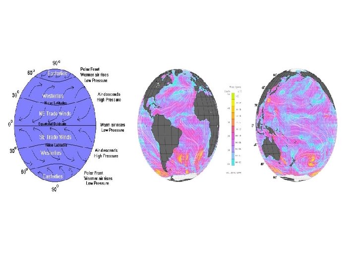
Geostrophic Flow • To a large extent, horizontal movement of ocean surface waters mirrors the long term average planetary circulation of the atmosphere. Three surface wind belts encircle each hemisphere: trade winds (equator to 30 degrees latitude), westerlies (30 to 60 degrees), and polar easterlies (60 to 90 degrees). The westerlies of middle latitudes and the trade winds of the tropics drive the most prominent features of ocean surface motion, large scale roughly circular current systems elongated in the east west direction known as gyres. • Subtropical gyres are centered near 30 degrees latitude in the North and South Atlantic, the North and South Pacific, and the Indian Ocean. Gyres in the Northern and Southern Hemispheres are similar except that they rotate in opposite directions because the Coriolis effect acts in opposite directions in the two hemispheres. • Viewed from above, subtropical gyres rotate in a clockwise direction in the Northern Hemisphere but in a counterclockwise direction in the Southern Hemisphere.
• • • Driven by the long term average winds in the subtropical highs, Ekman transport causes surface waters to move toward the central region of a subtropical gyre. This transport produces a broad mounding of water as high as 1 m (3 ft) above mean sea level near the center of the gyre. As more water is transported toward the center of the gyre, the surface slope of the mound becomes steeper. At the same time, the horizontal water pressure gradient produced under the sloping sea surface increases. In response to the horizontal gradient in water pressure, water moves from where the pressure is higher toward where the pressure is lower, that is, downhill. Surface water parcels flow outward and down slope from the center of the gyre. The Coriolis effect causes these parcels to shift direction to the right (CW) in the Northern Hemisphere (to the left or CCW in the Southern Hemisphere). Eventually, the outward directed pressure gradient force balances the apparent force due to the Coriolis effect and the water parcels flow around the gyre and parallel to contours of elevation of sea level. The horizontal movement of surface water arising from a balance between the pressure gradient force and the Coriolis force is known as geostrophic flow. As noted earlier, viewed from above, geostrophic flow in a subtropical gyre is clockwise in the Northern Hemisphere and counterclockwise in the Southern Hemisphere.
The long term average pattern of ocean surface currents
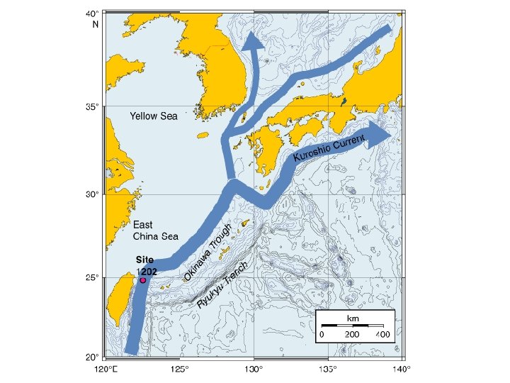
Gyres • The long term average pattern of ocean surface currents is plotted map on the previous slide. Some currents are relatively warm whereas others are cold. Winds associated with a passing storm system can disturb the ocean surface and cause the actual flow of ocean currents locally to deviate temporarily from long term average patterns. • Surface currents within gyres vary considerably in strength, width, and depth. The northeastward flowing Gulf Stream of the northwestern Atlantic and the Kuroshio Current of the northwestern Pacific are the swiftest surface currents with velocities averaging 3 to 4 km per hr (1. 8 to 2. 5 mph). Those currents are also relatively deep and narrow, usually measuring no more than 50 to 75 km (30 to 45 mi) across. On the eastern arms of these gyres, the southward flowing Canary and California Currents, respectively, are hundreds of kilometers wide and rarely flow at more than 1 km per hr (0. 6 mph).
The gyre has actually given birth to two large masses of ever accumulating trash, known as the Western and Eastern Pacific Garbage Patches, sometimes collectively called the Great Pacific Garbage Patch. The Eastern Garbage Patch floats between Hawaii and California; scientists estimate its size as two times bigger than Texas. The Western Garbage Patch forms east of Japan and west of Hawaii. Plastic has acutely affected albatrosses, which roam a wide swath of the northern Pacific Ocean. Albatrosses frequently grab food wherever they can find it, which leads to many of the birds ingesting and dying from plastic and other trash. On Midway Island, which comes into contact with parts of the Eastern Garbage Patch, albatrosses give birth to 500, 000 chicks every year. Two hundred thousand of them die, many of them by consuming plastic fed to them by their parents, who confuse it for food
Gyres con’t • The westward flowing South Equatorial Current links the two subtropical gyres of the Atlantic Ocean. • The eastward projection of Brazil splits the South Equatorial Current into two segments. The segment flowing southward forms the western arm of the South Atlantic gyre (the Brazil Current, a western boundary current). The segment flowing northward merges with the North Equatorial Current, which then splits into two currents that rejoin as they exit the Gulf of Mexico between Florida and Cuba to become the Florida Current. This current becomes the Gulf Stream that flows northeasterly and passes Cape Hatteras, NC. In that region, the current speed may be as great as 9 km per hr (5. 5 mph). Near Chesapeake Bay, the amount of water transported in the Gulf Stream exceeds 90 million cubic m per sec; the volume of water transported falls to about 40 million cubic m per sec by the time the current reaches southern Newfoundland. (For comparison purposes, 90 million cubic m per sec is equivalent to about 4500 times the discharge of the Mississippi River enough to fill the Lake Superior basin in about 1. 5 days. )
Equatorial Currents • • • The prevailing surface winds over the tropical ocean are the trade winds that blow persistently from the northeast (toward the southwest) in the Northern Hemisphere and from the southeast (toward the northwest) in the Southern Hemisphere. The name for these winds was coined by sea captains who sailed for trading companies and took advantage of their persistent speed and direction when crossing the ocean. Trade winds drive both North and South Equatorial Currents westward, thus transporting warm ocean surface waters in that direction. Equatorial Counter Currents and Equatorial Under Currents return some warm waters eastward. Counter Currents flow along the surface whereas Under Currents flow at greater depths below the surface.
• The trade winds of the two hemispheres converge in a narrow east west zone located near the equator known as the Intertropical Convergence Zone (ITCZ). It is important component of the planetary scale atmospheric circulation that is particularly well defined over the tropical ocean. • Warm and humid air ascending in the ITCZ gives rise to clusters of showers and thunderstorms that produce locally heavy rainfall. For mariners the region of the tropical ocean near the equator is known as the doldrums, feared by the captains of sailing ships because of light and variable winds. • Seasonally, the ITCZ moves with the sun, shifting northward during the Northern Hemisphere spring and southward during the Northern Hemisphere autumn but generally remaining north of the equator, especially over the Atlantic Ocean. Consequently, the eastward flowing Equatorial Counter Current, separating the surface current systems of the two hemispheres, also lies mostly just north of the equator.
• The South Equatorial Current crosses the equator in the Atlantic and to a lesser extent in the Pacific. In this way, it transports surface waters and heat into the Northern Hemisphere. The return flow is through subsurface currents). The cape at the easternmost point of South America diverts part of the flow of the South Equatorial Current into the southward flowing Brazil Current. The remainder continues northwestward along South America's northeast coast into the Caribbean Sea. • The islands of Indonesia mark the boundary between the Indian and Pacific Oceans but do not completely block the flow of seawater between the two ocean basins. Warm, low salinity waters from the Pacific are transported into the Indian Ocean's South Equatorial Current. These waters flow through the many passages between the thousands of Indonesian islands and replenish the large amounts of water removed by evaporation from the northern Indian Ocean. The summer Asian monsoon circulation transports this water vapor over India and Southeast Asia where it falls as torrential rains. After flowing westward across the Indian Ocean, these waters enter the South Atlantic via the Agulhas Current flowing around southern Africa. The Indonesian islands partially block the inter ocean flow, which leads to an accumulation of warm surface waters in the western equatorial Pacific Ocean that is linked to El Niño/La Niña.
Western Boundary Currents • Surface currents located on the western side of the subtropical gyres, so called western boundary currents, are faster than their eastern counterparts. In fact, they are among the fastest surface currents in the ocean. • One reason for the westward intensification of boundary currents has to do with the strengthening of the Coriolis effect with latitude. The Coriolis effect is stronger in the latitudes Transport of surface waters toward the western boundary of of the westerlies than in the ocean basins causes the ocean surface slope to be steeper on the western side (versus eastern side) of a gyre (in latitudes of the trade winds. either hemisphere). A steeper ocean surface slope translates into a faster geostrophic flow on that side of the gyre.
As shown here for the North Atlantic but also true for all ocean basins, the ocean surface slope is steeper on the western side of an ocean basin than on the eastern side. Consequently, surface ocean currents are stronger, narrower, and deeper in all western boundary regions. Note: vertical scale is greatly exaggerated. • Waters in western boundary currents typically move 40 to 120 km (25 and 75 mi) per day. These currents also extend much deeper than most other surface currents, down to a depth of 1000 m (3300 ft) or more. • The strong western boundary currents are so deep that they are deflected by the continental margins, which prevent these currents from flowing onto the shallow continental shelves. • Eastern boundary currents, such as the California Current and the Canary Current, are slower, shallower, and wider than the western boundary currents. Similar to the return flow in a household heating system, these currents transport colder waters into the tropics where they are heated and transported poleward in the western boundary currents.
Rings • • • The pool of water in a warm core ring can extend to a depth of 1500 m, they cannot move onto continental shelves, which are shallow typically 200 m deep. Rings can come close enough to the shelf edge to modify coastal currents and bring unusual organisms onto the shelf. Occasionally boaters and fishers in normally cool coastal waters encounter sea turtles and tropical fish transported in a warm core ring that spun off the Gulf Stream. Satellite images show that the ocean is turbulent in much the same way that the atmosphere is turbulent. For example, relatively swift western boundary currents can spawn large turbulent rotating warm core and cold core eddies, also known as rings. A ring forms when a meander in a boundary current (or the Antarctic Circumpolar Current) becomes a loop that separates from the main current and moves independently as an eddy. Currents bordering a ring can rotate at more than 1. 0 knot (1. 15 mph), essentially isolating waters and organisms in rings from surrounding waters. Rings extend to some depth in the ocean and should be thought of as cylindrical pools of rotating water rather than simply surface features.
• • Rings in the North Atlantic move slowly (5 to 6 km or 3 to 4 mi per day), drifting southwestward in the weaker currents on either side of the northeast flowing Gulf Stream. The proximity of the Gulf Stream to the coast limits the southward movement of warm core rings. Typically, after a few months to a year, a warm core ring becomes caught between Cape Hatteras, NC and the Gulf Stream; the ring is then reabsorbed back into the Gulf Stream. Cold core rings are not as restricted in their movements as warm core rings and may persist for several years; on average, individual cold core rings last for one and one half years. Some of the ocean's largest warm core rings with diameters up to 400 km (250 mi) form in the Gulf of Mexico. These rings spin off the Loop Current at highly irregular intervals ranging from several months to 1. 5 years. The Loop Current enters the Gulf from the Caribbean by flowing through the Yucatan Strait between Cuba and Mexico, heads northwestward in the general direction of Louisiana, then makes a clockwise turn, and exits the Gulf through the Straits of Florida (between Florida and Cuba). Rings drift westward across the Gulf at 2 to 5 km (1. 2 to 3. 1 mi) per day. Bordering currents of up to 4 knots (4. 6 mi per hr) can play havoc with offshore oil platform operations, damaging equipment and increasing the risk of accidents. Rings form in all ocean basins. For example, the Agulhas Current, the Indian Ocean's western boundary current, is a source of rings. This relatively fast southward flowing current averages about 7 km per hr (4 mph). As it reaches Africa's southern tip, part of the current is caught up in the eastward flow around Antarctica and abruptly shifts direction back into the Indian Ocean. Some of the flow continues around South Africa as narrow (50 km or 30 mi wide) filaments that cool rapidly and mix with the surrounding waters in the large upwelling zone off Africa's Namibia coast. The Agulhas Current periodically sheds rings about 320 km (200 mi) across from its westem most end. Rings in the Southern Hemisphere rotate in the opposite direction of those in the Northern Hemisphere. The Agulhas Current's warm core rings rotate counterclockwise and contain Indian Ocean waters that are about 5 Celsius degrees (9 Fahrenheit degrees) warmer than nearby South Atlantic surface waters. They retain their identity as they move into the South Atlantic and transport heat, salt and organisms from the Indian Ocean into the South Atlantic. Over a two year period in the mid 1990 s, 14 of these rings formed.
Upwelling Where Ekman transport moves surface waters away from the coast, surface waters are replaced by water that wells up from below in the process known as upwelling. This example is from the Northern Hemisphere. • the combination of persistent winds, Earth's rotation (the Coriolis effect), and restrictions on lateral movements of water caused by shorelines and shallow bottoms induces upward and downward water movements. The Coriolis effect plus the frictional coupling of wind and water (Ekman transport) cause net movement of surface water at about 90 degrees to the CW of the wind direction in the Northern Hemisphere. • Coastal upwelling occurs where Ekman transport moves surface waters away from the coast; surface waters are replaced by water that wells up from below.
• • Eastern boundary current flowing southward along the California coast of the Western, United States. The image is created from Sea Surface Temperature (SST) data from the MODIS instrument, on the Aqua satellite and shows upwelling in the California Current system. The range of orange and purple colors, depict cooler water temperatures resulting from upwelling. The grey shapes, on the left are clouds. Upwelling is most common along the west coast of continents (eastern sides of ocean basins). In the Northern Hemisphere, upwelling occurs along west coasts (e. g. , coasts of California, Northwest Africa) when winds blow from the north (causing Ekman transport of surface water away from the shore). Winds blowing from the south cause upwelling along continents' eastern coasts in the Northern Hemisphere, although it is not as noticeable because of the western boundary currents. Upwelling also occurs along the west coasts in the Southern Hemisphere (e. g. , coasts of Chile, Peru, and southwest Africa) when the wind direction is from the south because the net transport of surface water is westward away from the shoreline. Winds blowing from the north cause upwelling along the continents' eastern coasts in the Southern Hemisphere.
Downwelling Where Ekman transport moves surface waters toward the coast, the water piles up and sinks n the process known as downwelling. This example is from the Northern Hemisphere. • Where Ekman transport moves surface waters toward the coast, the water piles up and sinks in the process known as coastal downwelling. Upwelling and downwelling illustrate mass continuity in the ocean; that is, water is a continuous fluid so that a change in distribution of water in one area is accompanied by a compensating change in water distribution in another area.
Open Ocean Up & Downwelling • Upwelling and downwelling also occur in the open ocean where winds cause surface waters to diverge (move away) from a region (causing upwelling) or to converge toward some region (causing downwelling) • Upwelling takes place along much of the equator. Recall that the deflection due to the Coriolis effect reverses direction on either side of the equator. Hence, westward flowing, wind driven surface currents near the equator turn northward on the north side of the equator and southward on the south side. Surface waters are moved away from the equator and replaced by upwelling waters.
• • • Upwelling and downwelling influence sea surface temperature and biological productivity. Upwelling waters may originate below the pycnocline and are therefore colder than the surface waters they replace. Sometimes upwelling waters are confined to the mixed layer depending on the thickness of the warm layer. You may have experienced upwelling at the beach on a windy day when the warm surface water was blown offshore and replaced by chilly water from below. Where thermocline is shallow, the upwelling waters are usually rich in the dissolved nutrients (e. g. , nitrogen and phosphate compounds) required for phytoplankton growth. This nutrient transport into the surface waters where sunlight, also required for phytoplankton growth (photic zone), is present, results in rapid growth of phytoplankton populations. Since phytoplankton form the base of marine food webs, the world's most productive fisheries are located in areas of coastal upwelling that bring cold nutrient rich waters to the surface (especially in the eastern boundary regions of the subtropical gyres); about half the world's total fish catch comes from upwelling zones. On the other hand, in zones of coastal downwelling, the surface layer of warm, nutrient deficient water thickens as water sinks. Downwelling reduces biological productivity and transports heat, dissolved materials, and surface waters rich in dissolved oxygen to greater depths. This occurs along the west coast of Alaska in the eastern boundary region of the Gulf of Alaska gyre (driven by winds in the Aleutian low). Alternate upwelling of nutrient poor and nutrient rich waters off the coast of Ecuador and Peru are associated with El Niño and La Niña episodes in the tropical Pacific. During El Niño the pycnocline is so deep that the upwelled waters come from the nutrient poor waters above the pycnocline. In extreme cases, nutrient deficient waters coupled with over fishing cause fisheries to collapse bringing about severe, extended economic impacts. Coastal upwelling and downwelling also influence weather and climate. Along the northern and central California coast, upwelling lowers sea surface temperatures and increases the frequency of summer fogs. Relatively cold surface waters chill the overlying humid marine air to saturation so that thick fog develops. Upwelling cold water inhibits formation of tropical cyclones (e. g. , hurricanes), because tropical cyclones derive their energy from warm surface waters. During El Niño and La Niña, changes in sea surface temperature patterns associated with warm and cold water upwelling off the northwest coast of South America and along the equator in the tropical Pacific affect the inter annual distribution of precipitation around the globe.
Ocean Conveyor Belt The global oceanic conveyer is a unifying concept that connects the ocean's surface and thermohaline (deep mass) circulation regimes, transporting heat and salt on a planetary scale.
• The conveyor belt system can be thought of as beginning near Greenland Iceland in the North Atlantic where dry, cold winds blowing from northern Canada chill surface waters. The combined chilling of surface waters, evaporation, and sea ice formation produces cold, salty North Atlantic Deep Water (NADW). The newly formed NADW sinks and flows southward along the continental slope of North and South America toward Antarctica where the water mass then flows eastward around the Antarctic continent (in the Antarctic Circumpolar Current). There the NADW mixes with Antarctic waters (i. e. , AABW and AADW). The resulting Common Water, also called Antarctic Circumpolar water, flows northward at depth into the three ocean basins (primarily the Pacific and Indian Oceans). • These bottom waters gradually warm and mix with overlying waters as they flow northward. They move to the surface at a rate of only a few meters per year. After rising to the surface in the Pacific, the surface waters flow through the many passages between the Indonesian islands into the Indian Ocean. Eventually they flow into the Agulhas Current, the Indian Ocean boundary current that flows around southern Africa. After entering the Atlantic Ocean, the surface waters join the wind driven currents in the Atlantic, becoming saltier by evaporation under the intense tropical sun. Trade winds transport some of this water vapor out of the Atlantic Ocean basin, across the Isthmus of Panama, and into the Pacific Ocean basin. Atlantic surface waters eventually return northward to the Labrador and Greenland seas in the North Atlantic.