Ocean Basins and Coastal Landforms Five Ocean Basins

Ocean Basins and Coastal Landforms

Five Ocean Basins and “Seven Seas”

A Closer Look: Continental Shelf and Continental Slope

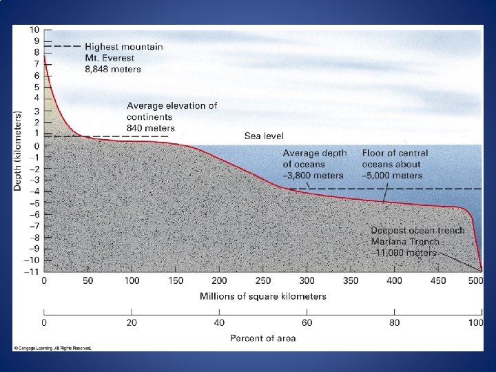
q Ocean basins cover 71% of Earth q 2 to 11 km in depth (approx. 5 km average) q 1. 4 billion km 3 water q No basins, water would be 2 km deep everywhere q Where did water come from? § Native volatiles – water and carbon dioxide - from the molten early Earth were gases from initial coalescence of planets and the solar system § Cometary water hypothesis – solar wind and the moon-forming impact would have caused net loss of volatiles – Earth’s early surface had neither water nor an atmosphere but the early solar system was full of comets formed by escaped volatiles from the inner planets – comets later crashed onto Earth’s surface returning 90% of the volatile compounds that eventually formed Earth’s atmosphere and Oceans § Why do volcanoes still spew water vapor? Volatiles recycled with tectonic activity

Sea-level has risen and fallen in the past § Sea-level is rising presently approx. 3 mm/yr § Warming temperatures raise sea level by a) Thermal expansion of water and b) Melting and release of glacial water

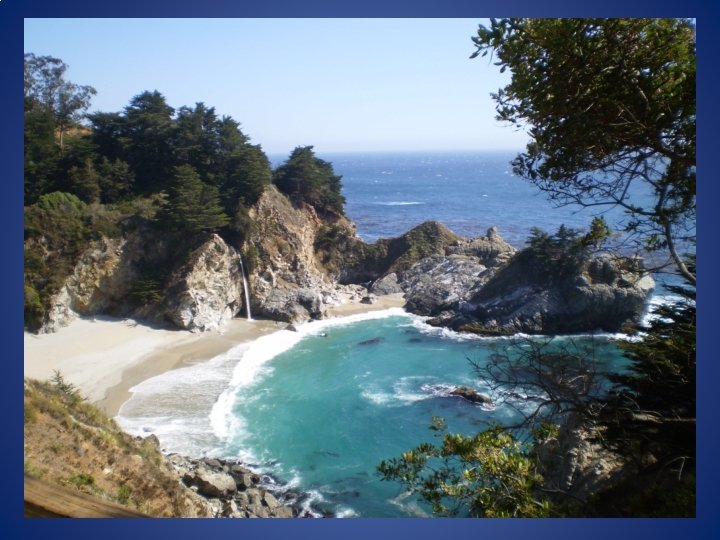
The Coastal Environment § The World Ocean covers 71% of Earth’s surface, and the world’s shoreline is of enormous length § Earth’s coastlines have tremendous resource, and they are biologically and geomorphically diverse § Their spectacular scenery bring in more tourists than any other natural environment, and continue to attract new residents § But they are also subject to an array of natural hazards, and human-induced environmental problems; ironically, some of our most polluted waters are found in coastal locations § Global warming and resulting sea level rise will have profound consequences for coastal zones

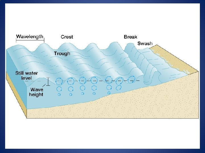
The Coastal Zone: Definitions Coastal Zone: General region of interaction between the land the ocean Shoreline or Coastline: Constantly changing contact between the ocean surface and the dry land Sea Level: Average position of the ocean shoreline from which all elevations are measured Swash: The thin sheet of water rushing towards the shoreline Backwash: The return flow of water to the ocean Nearshore Zone: Comprises Breaker Zone, Surf Zone and Swash Zone (See Fig. 17. 1, p. 407 in Text) Offshore Zone: Undefined zone seaward, beyond the breaker zone
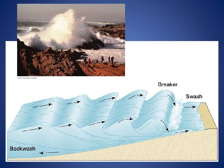

Waves and Currents Waves : are travelling, repeating forms of alternating highs and lows called wave crests and wave troughs – induced by Wind Currents : horizontal movement of ocean water, usually in response to atmospheric circulation also, rip currents, long shore currents

Wave Refraction – waves change directional trend as they approach shore. Raglan, New Zealand

Basic Concepts I. Repeated sea level changes in the past • Estimated 422 ft. rise since 18, 000 years ago • specific landscapes submergent (Passive) or emergent (Active) depending on tectonic change II. Waves and resultant currents erode, transport, and deposit sediment load. • rocky headlands • beaches III. Tides affect all coastal life but have little topographic effect. • tidal bore/tidal wave/storm surge/tsunami
 sea level")
Submergent vs. Emergent Coastlines • During the ice ages (or glacial periods) sea level sinks as more water is tied up in glaciers • During interglacial periods sea level rises, flooding many river valleys, creating bays and estuaries • Submergent Coastlines Rias: drowned river valleys; Fjords: drowned glacial valleys • Sea levels rise also causes many features of the former shore to lie underwater • Also known as Passive-margin Coasts – e. g. , Atlantic Coast – because tectonic activity occurs in the middle of the ocean, and the coast is tectonically passive.

Submergent Coastlines Sea level rise inundated many coastal valleys creating bays and estuaries. These coasts are often referred to as Ria coastlines. Estuary – An arm of the sea that extends inland i. e. , an inlet) to meet the mouth of a river.

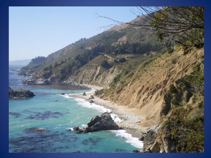
Emergent Coastlines where water level has fallen, or land has risen due to tectonic activity In areas with “rapid” tectonic uplift, Emergent Coastlines and cliffs are common, and bays are rare Also called Activemargin Coast – e. g. , Pacific Coast Tectonic forces lift coastlines faster than sea-level rises. Dramatic sea cliffs and marine terraces tower above the sea. Also, sea stacks. Most activity occurs along active subduction zones and transform plate boundaries.

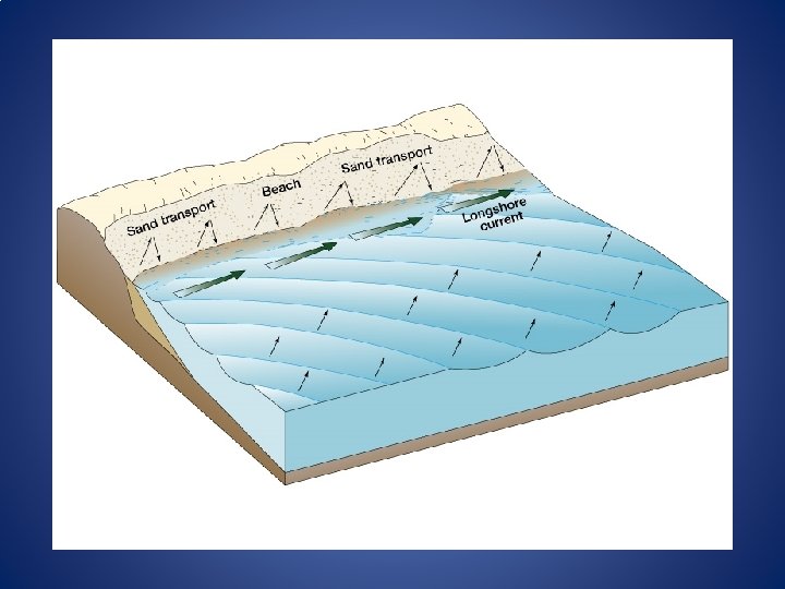
COASTAL PROCESSES AND LANDFORMS Coastal Erosion – dependent on wave size, angle, and frequency. Focused where waves contact coastline. • Headlands, sea cliffs, bluffs, sea stacks, natural bridges • Beach Erosion Coastal Transportation – Large waves move beach sand offshore. Small waves push it back onshore. • Wave action creates strong currents parallel to shore – Longshore currents, and longshore drifting. Ø Also Littoral drifting and beach drifting. Coastal Deposition – where wave action is reduced, beaches and dunes form. • Beaches, dunes, sand spits

Coastal Erosion Hydraulic action: Sheer physical force, the pounding of waves against coastal rock material. Abrasion: The process of wearing down or rubbing away by means of friction.

Isla Vista Beach, October 2001

Isla Vista Beach, December 2002

Beach Erosion

Formation of Marine Terrace

Marine Terraces

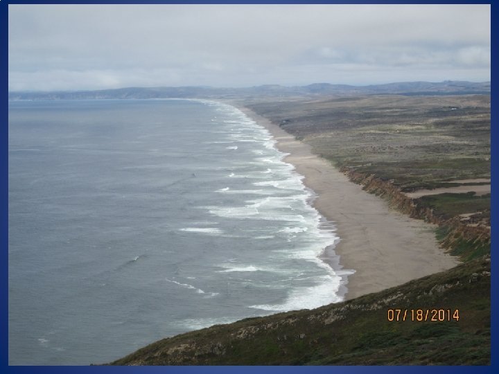
Point Reyes National Seashore California

Sea Stacks Port Campbell National Park, Victoria, Australia

Natural Bridges and Arches Port Campbell National Park, Victoria, Australia

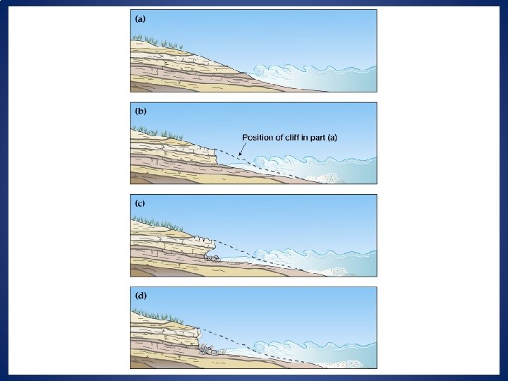
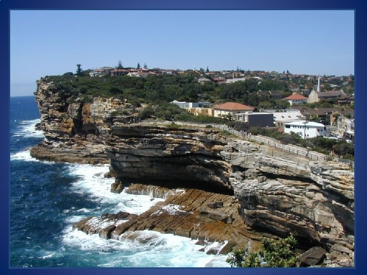
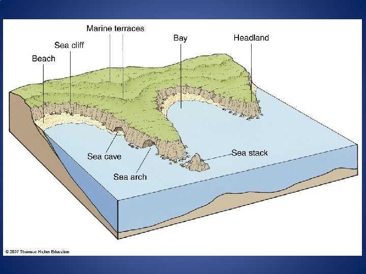
Erosional Landforms 1. Sea Cliffs: When Waves pound directly against steep land 2. Sea Caves: Erosion, corrosion and hydraulic action along lines of weakness 3. Sea Arches: 2 caves meet from each side of hydraulic action of a headland 4. Sea Stacks: A resistant pillar is left standing – the remnant is called a sea stack 5. Marine Terraces: Formed by tectonic activity uplift out of reaches of wave action 6. Headlands: Prortruded land, flanked by receding bays

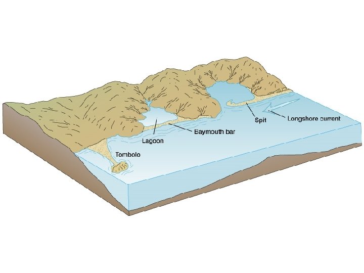
Depositional Landforms 1. Beach: Landform of coastal deposition, continuous with the mainland Sandy beaches, Pebble and boulder beaches, White coral reef beaches, Black sandy beaches – in volcanic Big Island, Hawaii 2. Spits: Coastal depositional landforms connected to the mainland at just one end 3. Barrier beaches: long depositional feature constructed parallel to mainland, protection from direct wave attack 4. Lagoon: Body of water partially or fully enclosed by baymouth bar 5. Tombolo: Strip of sediment connecting mainland to an island

Tombolo

Tombolo

Sand Spit

Sand Spit

Barrier Islands

Barrier Islands

Point Reyes National Seashore, California

Point Reyes Lighthouse

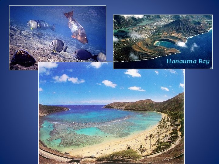
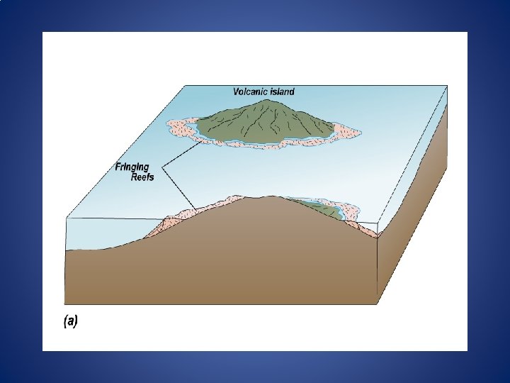
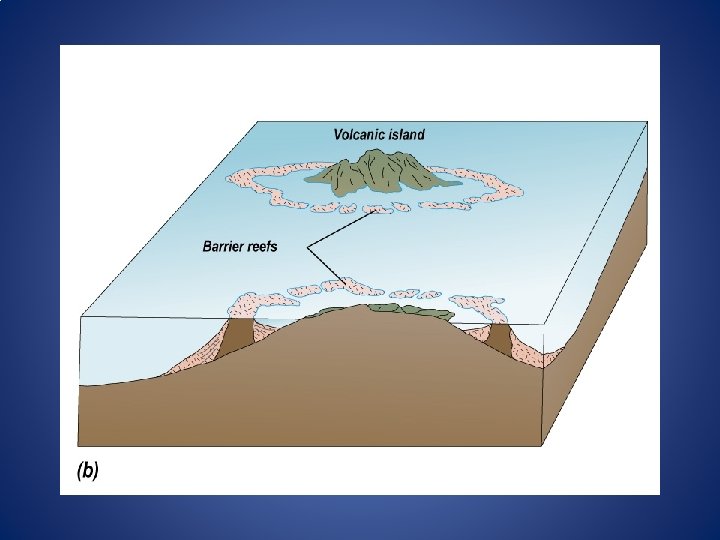
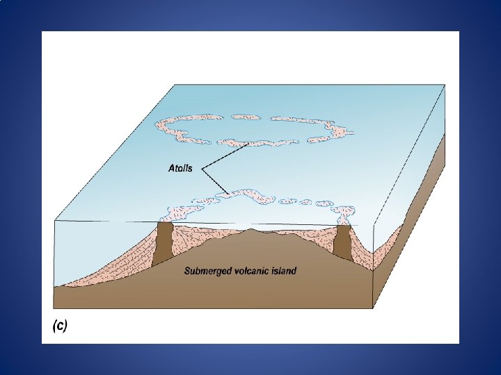
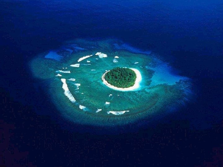
Islands Types of Islands 1. Continental Islands – separated from mainland due to shore submergence 2. Oceanic Islands – volcanic islands 2. Atoll – coral formation

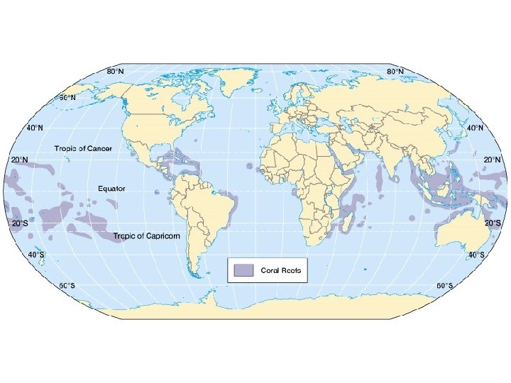
Tropical Coasts and Coral Growth

Factors Correlated with Healthy Coral Reef Growth • • • Water temperature range: 18 – 29 C Normal seawater salinity: 32 – 35 ‰ Clear, transparent water Little or no sedimentation Vigorous water motion

Tropical Mangroves

Mangroves create tidal forests. These rich ecosystems provide habitat for countless creatures and help to stabilize and, by catching sediment, even create coastline.

Tides Low Tide, New Brunswick

Tides Tide Cycle Tides rise and fall with the rising moon, an interval of 24 hours and 50 minutes. There is a bulge on both sides of the earth. Thus two high tides each cycle. Flood tide (low to high) takes 6: 13 and then ebb tide (back to low) is another 6: 13.

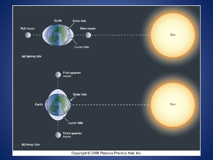
Tides Tide Range Tide range dependent on relative position of earth, moon, and sun. Spring Tides - highest tidal range Neap Tides - lowest tidal range Occurs every 2 weeks

Tidal Patterns in the U. S.

Tides Not significant as a geomorphic agent, but can be very consequential when coinciding with storm surges or tsunamis
- Slides: 63