Northampton Hazard Mitigation Plan FEMA sustained action to


- Slides: 12
Northampton Hazard Mitigation Plan FEMA: “…sustained action to reduce or eliminate long-term risk to people and property from natural hazards such as flooding, storms, high winds, hurricanes, wildfires, earthquakes”
Context Comprehensive Emergency Management Plan Northampton Zoning PVPC Climate Action Plan PVPC Regional Land Use Plan
Hazard Mitigation Plan 4 FEMA Hazard Mitigation funds � $2. 5 million in current/pending funds Mitigation is less expensive than disaster � $25 million from a 100 year flood Coordinate planning Climate change effects on natural hazards
5 Northampton Hazard Mitigation Process Hazard Mitigation Committee: � Planning & Sustainability, Emergency Management, Fire Department, Public Works, Central Services, Building Pioneer Valley Planning Commission Two public hearings Press: Gazette, Republican, WWLP Channel 22 FEMA and MEMA review and approval
Hazard Assessment Type of Hazard Location of Occurrence Probability of Future Events Impact Hazard Risk Index Rating Flooding Medium High Limited 2 Severe Ice and Snowstorms Large High Minor 3 Severe Thunderstorms / winds / tornadoes Small / Medium Low / Very Low Critical 2/4 Hurricanes Large Low Critical 2 Wildfire/Brushfire Small Low Minor 4 Earthquakes Large Very low Critical 4 Dike/Dam Failure Large Very low Catastrophic 2
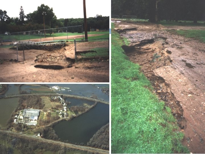
7 Flood Hazard Areas: 100 & 500 year Does NOT include: localized flooding, dam or dike failures
Flood Hazard Areas: The big one! 8
Climate Change- underway 9 Zoning: Regulates to 500 year flood Health: Emergency cooling Central Services/DPW: Micro-grid (DPW, Smith-Voc shelter, Cooley Dickinson Hospital) Planning et al: Climate Change Plan in process
Climate Change expectations 10 Average summer temperature: 68˚ TO 74˚ 82˚ Days over 90˚: 5 -20 days To 30 -60 days Annual precipitation: 41” to 44 -47” Increase in peak storms
Critical Infrastructure Affected Hazard Type Hazard Area Critical Facilities Affected Evacuation Routes Affected Flooding Mill River Connecticut River IF dikes fail, downtown floods Route 10 (extreme) Route 5; Route 66; Route 9. Severe Snowstorms / Ice Storms Entire City Cooley Dickinson power outage Nursing Homes Route 10 (extreme) Route 5; Route 66; Route 9. Severe Thunderstorms / wind / tornadoes Entire City: Pine Brook (2000) Burts Pit (2002) Site Specific Hurricanes Mill River Connecticut River IF dikes fail, downtown floods Route 10 (extreme) Route 5; Route 66; Route 9. Wildfire/Brushfire Western Northampton Watershed Lands Site Specific Entire City Emergency operations; all structures; shelters; waste treatment Route 91 (extreme) Route 5; Route 66; Route 9. Earthquakes Dam Failure Drought Entire City Fire fighting operations Site Specific None
Revised Mitigation Strategies 12 Emergency Management Plan: No changes Subdivision regulations: No changes Zoning: No land use changes, small tweaks only FEMA Community Rating System: already underway Flood control: Stormwater utility & FEMA investments Utilities: Undergrounding in repetitive outage areas