NOAACIMSS Prob Severe version 2 all hazards Training
NOAA/CIMSS Prob. Severe version 2 (all hazards) – Training Module – Spring 2019 National Oceanic & Atmospheric Administration Cooperative Institute for Meteorological Satellite Studies University of Wisconsin - Madison Cooperative Institute for Research in the Atmosphere Colorado State University 1
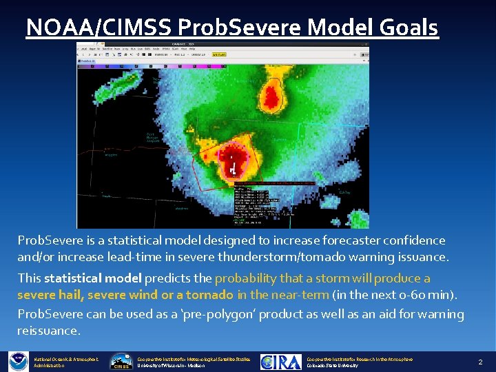
NOAA/CIMSS Prob. Severe Model Goals Prob. Severe is a statistical model designed to increase forecaster confidence and/or increase lead-time in severe thunderstorm/tornado warning issuance. This statistical model predicts the probability that a storm will produce a severe hail, severe wind or a tornado in the near-term (in the next 0 -60 min). Prob. Severe can be used as a ‘pre-polygon’ product as well as an aid for warning reissuance. National Oceanic & Atmospheric Administration Cooperative Institute for Meteorological Satellite Studies University of Wisconsin - Madison Cooperative Institute for Research in the Atmosphere Colorado State University 2

Prob. Severe v 2 Probabilities are a function of the dynamic and thermodynamic environment and observations Prob. Hail: • a priori: 0. 03 • MESH vs. Wet Bulb 0°C Height • Flash Rate vs. EBS • CAPE in -10°C to -30°C layer vs Precipitable Water • Satellite Growth Rate Prob. Wind: • a priori: f(Mean. Wind 1 -3 km AGL/ MLCAPE) • VIL Density • Flash Rate vs 3 -6 km Az. Shear • Mean. Wind 1 -3 km AGL vs. 0 -2 km Az. Shear • Satellite Growth Rate Prob. Tor: • a priori: 0. 01 • Max 0 -2 km Az. Shear • 98 th %ile 0 -2 km Az. Shear vs. 0 -1 km SRH • 98 th %ile 3 -6 km Az. Shear vs. max flash density • EBS vs. Mean. Wind 1 -3 km AGL • MLCAPE; MLCIN National Oceanic & Atmospheric Administration Cooperative Institute for Meteorological Satellite Studies University of Wisconsin - Madison Cooperative Institute for Research in the Atmosphere Colorado State University 3
AWIPS-II Display National Oceanic & Atmospheric Administration Cooperative Institute for Meteorological Satellite Studies University of Wisconsin - Madison Cooperative Institute for Research in the Atmosphere Colorado State University 4
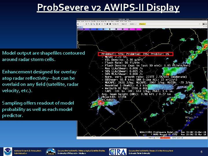
Prob. Severe v 2 AWIPS-II Display Model output are shapefiles contoured around radar storm cells. Enhancement designed for overlay atop radar reflectivity—but can be overlaid on any field (satellite, radar velocity, etc. ). Sampling offers readout of model probability as well as each model predictor. National Oceanic & Atmospheric Administration Cooperative Institute for Meteorological Satellite Studies University of Wisconsin - Madison Cooperative Institute for Research in the Atmosphere Colorado State University 5
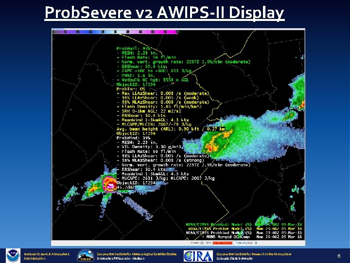
Prob. Severe v 2 AWIPS-II Display National Oceanic & Atmospheric Administration Cooperative Institute for Meteorological Satellite Studies University of Wisconsin - Madison Cooperative Institute for Research in the Atmosphere Colorado State University 6
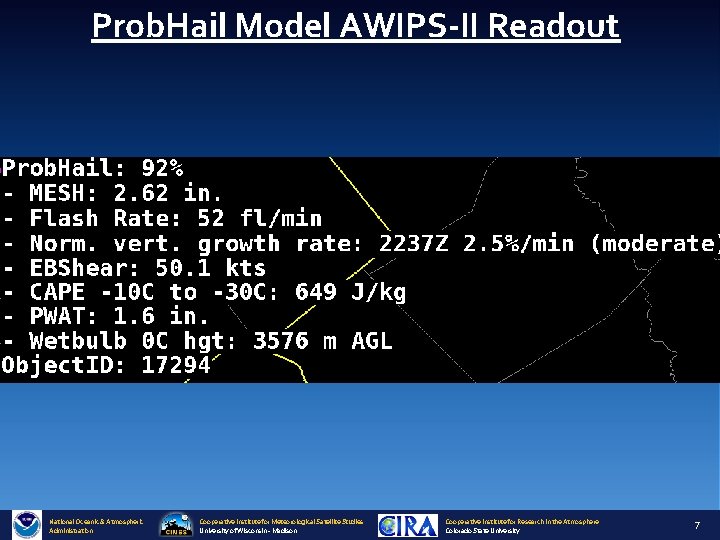
Prob. Hail Model AWIPS-II Readout National Oceanic & Atmospheric Administration Cooperative Institute for Meteorological Satellite Studies University of Wisconsin - Madison Cooperative Institute for Research in the Atmosphere Colorado State University 7
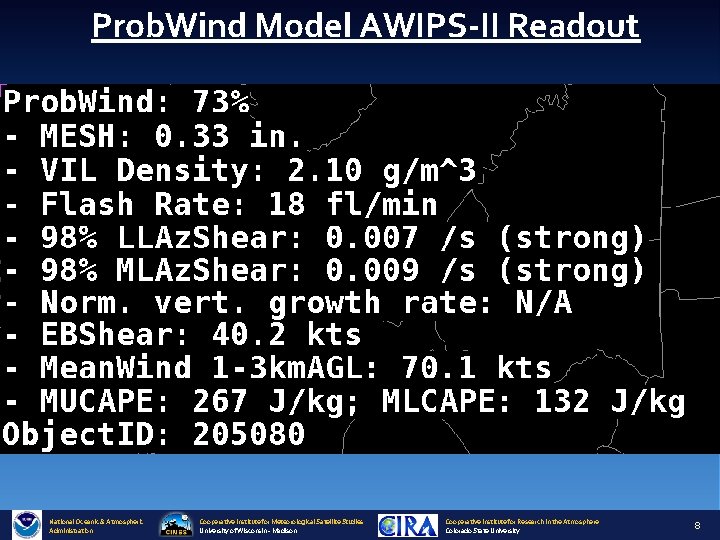
Prob. Wind Model AWIPS-II Readout National Oceanic & Atmospheric Administration Cooperative Institute for Meteorological Satellite Studies University of Wisconsin - Madison Cooperative Institute for Research in the Atmosphere Colorado State University 8
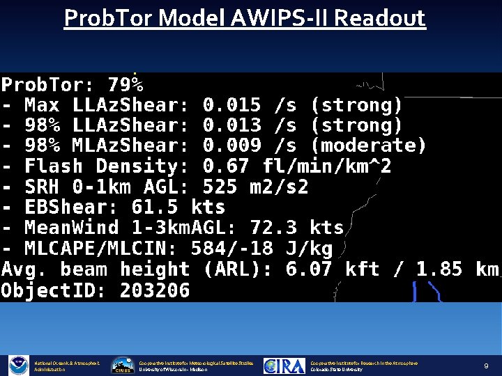
Prob. Tor Model AWIPS-II Readout National Oceanic & Atmospheric Administration Cooperative Institute for Meteorological Satellite Studies University of Wisconsin - Madison Cooperative Institute for Research in the Atmosphere Colorado State University 9
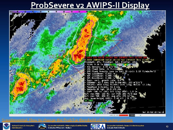
Prob. Severe v 2 AWIPS-II Display Supplemental: How to change the Prob. Tor threshold of the outer contour National Oceanic & Atmospheric Administration Cooperative Institute for Meteorological Satellite Studies University of Wisconsin - Madison Cooperative Institute for Research in the Atmosphere Colorado State University 10
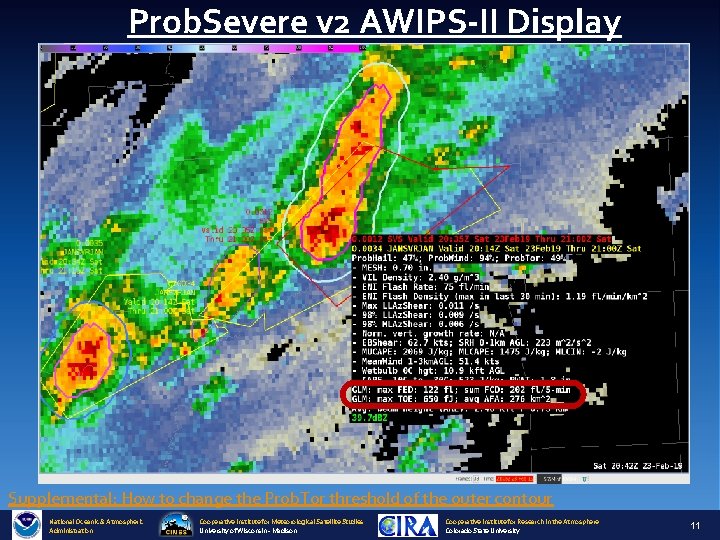
Prob. Severe v 2 AWIPS-II Display Supplemental: How to change the Prob. Tor threshold of the outer contour National Oceanic & Atmospheric Administration Cooperative Institute for Meteorological Satellite Studies University of Wisconsin - Madison Cooperative Institute for Research in the Atmosphere Colorado State University 11

Examples National Oceanic & Atmospheric Administration Cooperative Institute for Meteorological Satellite Studies University of Wisconsin - Madison Cooperative Institute for Research in the Atmosphere Colorado State University 12
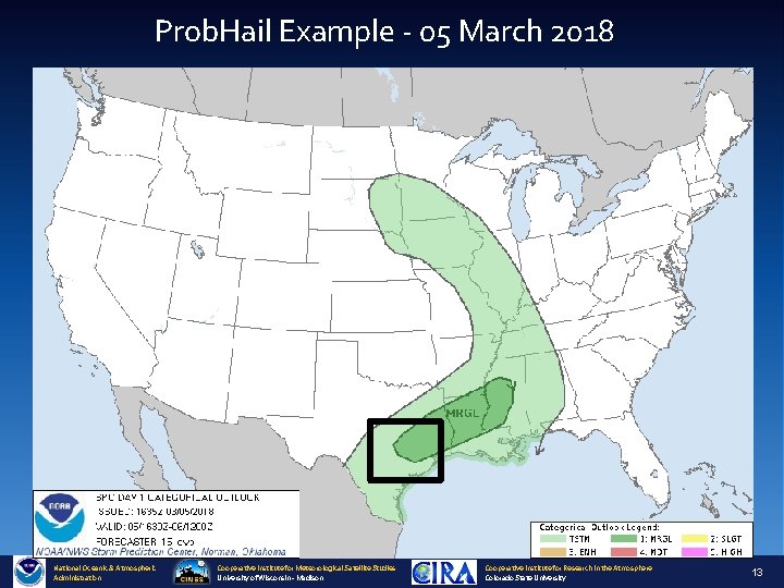
Prob. Hail Example - 05 March 2018 National Oceanic & Atmospheric Administration Cooperative Institute for Meteorological Satellite Studies University of Wisconsin - Madison Cooperative Institute for Research in the Atmosphere Colorado State University 13
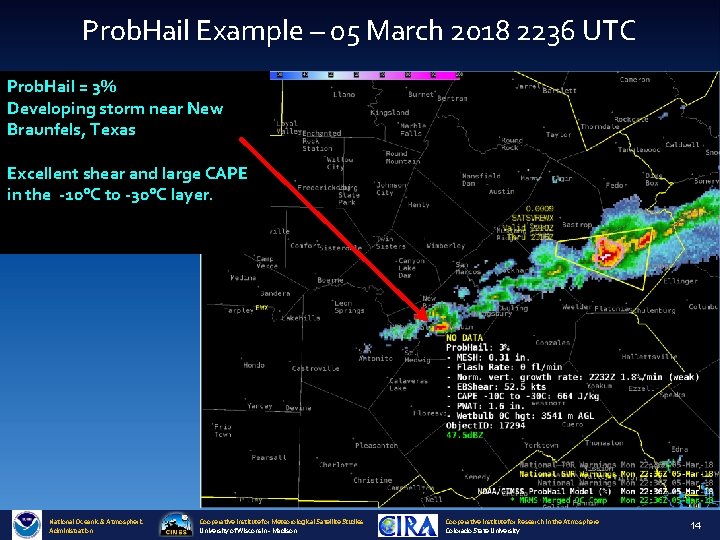
Prob. Hail Example – 05 March 2018 2236 UTC Prob. Hail = 3% Developing storm near New Braunfels, Texas Excellent shear and large CAPE in the -10°C to -30°C layer. National Oceanic & Atmospheric Administration Cooperative Institute for Meteorological Satellite Studies University of Wisconsin - Madison Cooperative Institute for Research in the Atmosphere Colorado State University 14
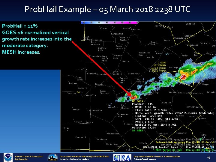
Prob. Hail Example – 05 March 2018 2238 UTC Prob. Hail = 11% GOES-16 normalized vertical growth rate increases into the moderate category. MESH increases. National Oceanic & Atmospheric Administration Cooperative Institute for Meteorological Satellite Studies University of Wisconsin - Madison Cooperative Institute for Research in the Atmosphere Colorado State University 15
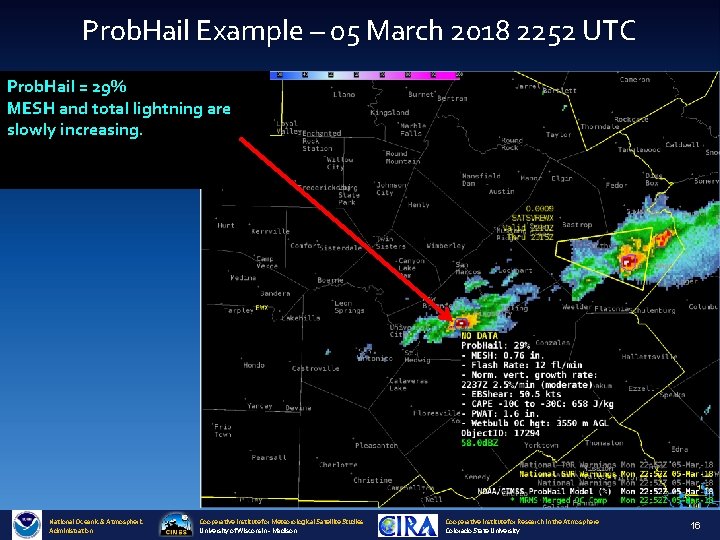
Prob. Hail Example – 05 March 2018 2252 UTC Prob. Hail = 29% MESH and total lightning are slowly increasing. National Oceanic & Atmospheric Administration Cooperative Institute for Meteorological Satellite Studies University of Wisconsin - Madison Cooperative Institute for Research in the Atmosphere Colorado State University 16
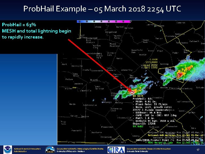
Prob. Hail Example – 05 March 2018 2254 UTC Prob. Hail = 63% MESH and total lightning begin to rapidly increase. National Oceanic & Atmospheric Administration Cooperative Institute for Meteorological Satellite Studies University of Wisconsin - Madison Cooperative Institute for Research in the Atmosphere Colorado State University 17
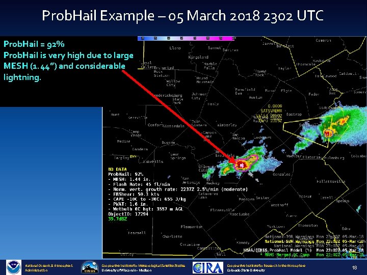
Prob. Hail Example – 05 March 2018 2302 UTC Prob. Hail = 92% Prob. Hail is very high due to large MESH (1. 44”) and considerable lightning. National Oceanic & Atmospheric Administration Cooperative Institute for Meteorological Satellite Studies University of Wisconsin - Madison Cooperative Institute for Research in the Atmosphere Colorado State University 18
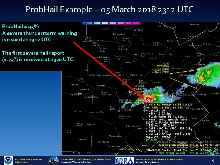
Prob. Hail Example – 05 March 2018 2312 UTC Prob. Hail = 95% A severe thunderstorm warning is issued at 2312 UTC. The first severe hail report (1. 75”) is received at 2320 UTC. National Oceanic & Atmospheric Administration Cooperative Institute for Meteorological Satellite Studies University of Wisconsin - Madison Cooperative Institute for Research in the Atmosphere Colorado State University 19
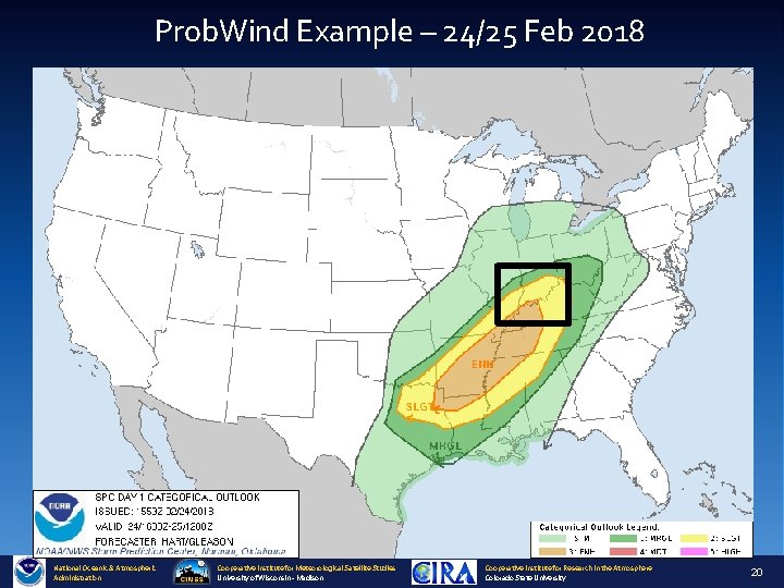
Prob. Wind Example – 24/25 Feb 2018 National Oceanic & Atmospheric Administration Cooperative Institute for Meteorological Satellite Studies University of Wisconsin - Madison Cooperative Institute for Research in the Atmosphere Colorado State University 20
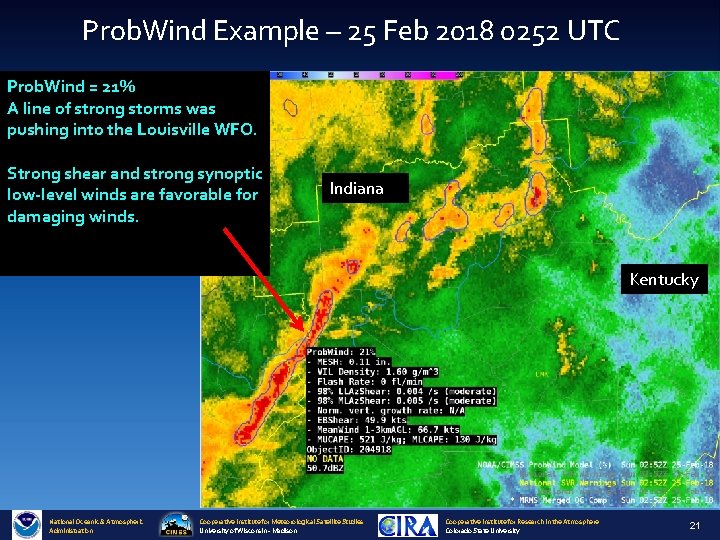
Prob. Wind Example – 25 Feb 2018 0252 UTC Prob. Wind = 21% A line of strong storms was pushing into the Louisville WFO. Strong shear and strong synoptic low-level winds are favorable for damaging winds. Indiana Kentucky National Oceanic & Atmospheric Administration Cooperative Institute for Meteorological Satellite Studies University of Wisconsin - Madison Cooperative Institute for Research in the Atmosphere Colorado State University 21
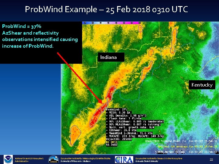
Prob. Wind Example – 25 Feb 2018 0310 UTC Prob. Wind = 37% Az. Shear and reflectivity observations intensified causing increase of Prob. Wind. Indiana Kentucky National Oceanic & Atmospheric Administration Cooperative Institute for Meteorological Satellite Studies University of Wisconsin - Madison Cooperative Institute for Research in the Atmosphere Colorado State University 22
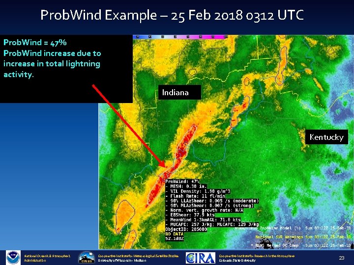
Prob. Wind Example – 25 Feb 2018 0312 UTC Prob. Wind = 47% Prob. Wind increase due to increase in total lightning activity. Indiana Kentucky National Oceanic & Atmospheric Administration Cooperative Institute for Meteorological Satellite Studies University of Wisconsin - Madison Cooperative Institute for Research in the Atmosphere Colorado State University 23
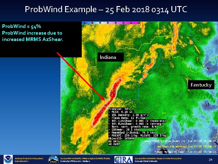
Prob. Wind Example – 25 Feb 2018 0314 UTC Prob. Wind = 54% Prob. Wind increase due to increased MRMS Az. Shear. Indiana Kentucky National Oceanic & Atmospheric Administration Cooperative Institute for Meteorological Satellite Studies University of Wisconsin - Madison Cooperative Institute for Research in the Atmosphere Colorado State University 24
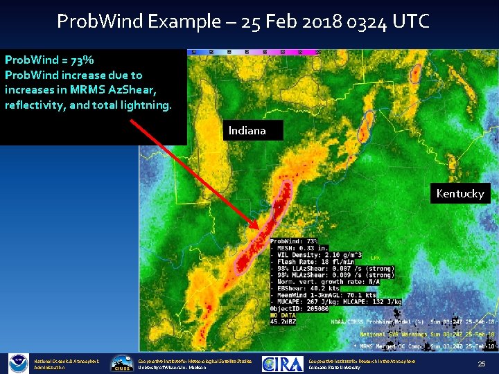
Prob. Wind Example – 25 Feb 2018 0324 UTC Prob. Wind = 73% Prob. Wind increase due to increases in MRMS Az. Shear, reflectivity, and total lightning. Indiana Kentucky National Oceanic & Atmospheric Administration Cooperative Institute for Meteorological Satellite Studies University of Wisconsin - Madison Cooperative Institute for Research in the Atmosphere Colorado State University 25
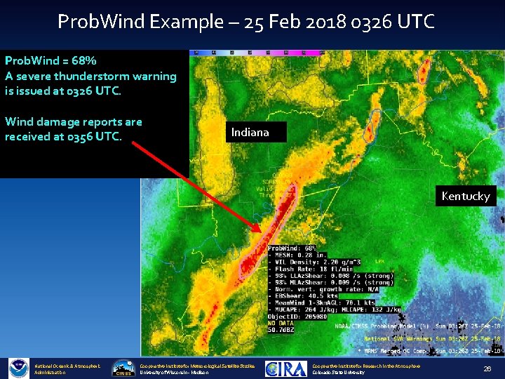
Prob. Wind Example – 25 Feb 2018 0326 UTC Prob. Wind = 68% A severe thunderstorm warning is issued at 0326 UTC. Wind damage reports are received at 0356 UTC. Indiana Kentucky National Oceanic & Atmospheric Administration Cooperative Institute for Meteorological Satellite Studies University of Wisconsin - Madison Cooperative Institute for Research in the Atmosphere Colorado State University 26
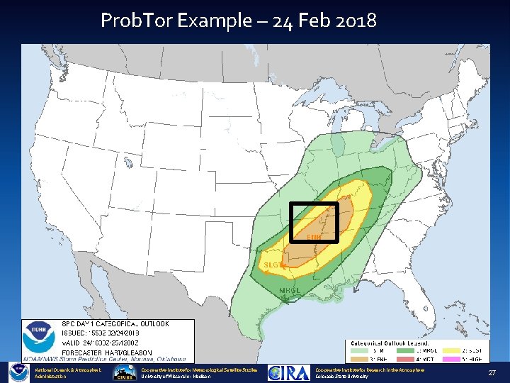
Prob. Tor Example – 24 Feb 2018 National Oceanic & Atmospheric Administration Cooperative Institute for Meteorological Satellite Studies University of Wisconsin - Madison Cooperative Institute for Research in the Atmosphere Colorado State University 27
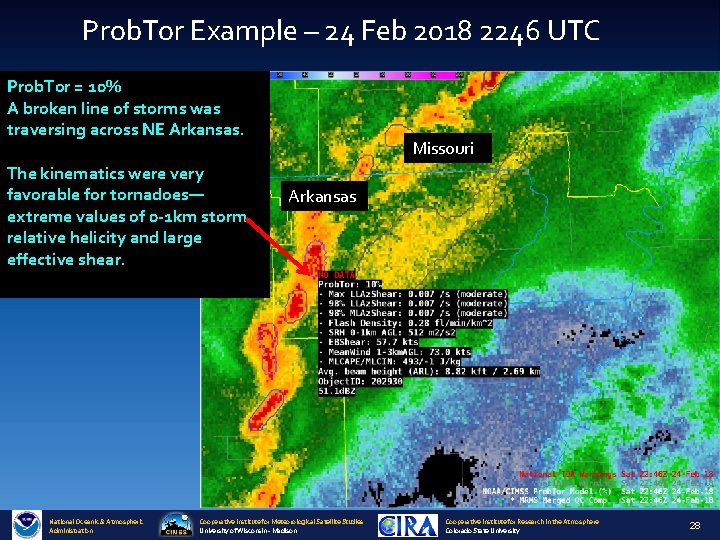
Prob. Tor Example – 24 Feb 2018 2246 UTC Prob. Tor = 10% A broken line of storms was traversing across NE Arkansas. The kinematics were very favorable for tornadoes— extreme values of 0 -1 km storm relative helicity and large effective shear. National Oceanic & Atmospheric Administration Missouri Arkansas Cooperative Institute for Meteorological Satellite Studies University of Wisconsin - Madison Cooperative Institute for Research in the Atmosphere Colorado State University 28
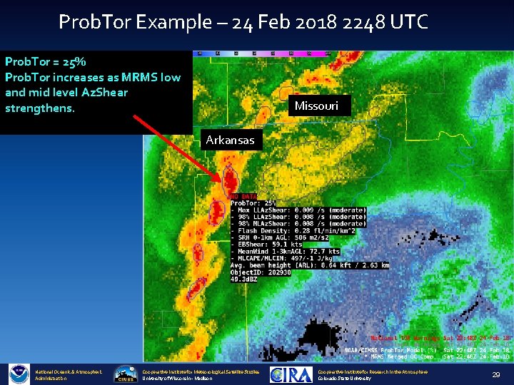
Prob. Tor Example – 24 Feb 2018 2248 UTC Prob. Tor = 25% Prob. Tor increases as MRMS low and mid level Az. Shear strengthens. Missouri Arkansas National Oceanic & Atmospheric Administration Cooperative Institute for Meteorological Satellite Studies University of Wisconsin - Madison Cooperative Institute for Research in the Atmosphere Colorado State University 29
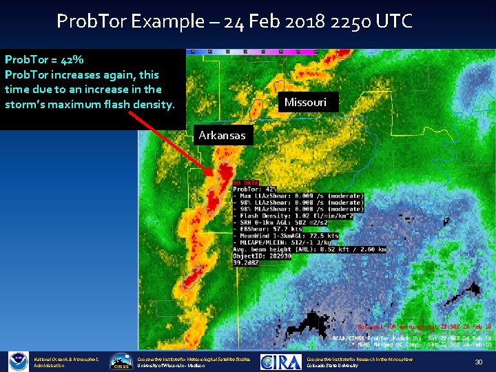
Prob. Tor Example – 24 Feb 2018 2250 UTC Prob. Tor = 42% Prob. Tor increases again, this time due to an increase in the storm’s maximum flash density. Missouri Arkansas National Oceanic & Atmospheric Administration Cooperative Institute for Meteorological Satellite Studies University of Wisconsin - Madison Cooperative Institute for Research in the Atmosphere Colorado State University 30
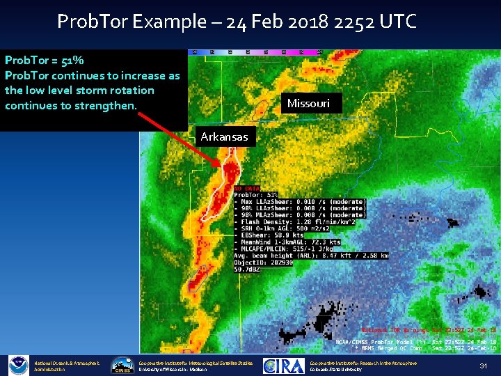
Prob. Tor Example – 24 Feb 2018 2252 UTC Prob. Tor = 51% Prob. Tor continues to increase as the low level storm rotation continues to strengthen. Missouri Arkansas National Oceanic & Atmospheric Administration Cooperative Institute for Meteorological Satellite Studies University of Wisconsin - Madison Cooperative Institute for Research in the Atmosphere Colorado State University 31
Prob. Tor Example – 24 Feb 2018 2306 UTC Prob. Tor = 52% A tornado warning is issued at 2307 UTC. Missouri Arkansas National Oceanic & Atmospheric Administration Cooperative Institute for Meteorological Satellite Studies University of Wisconsin - Madison Cooperative Institute for Research in the Atmosphere Colorado State University 32
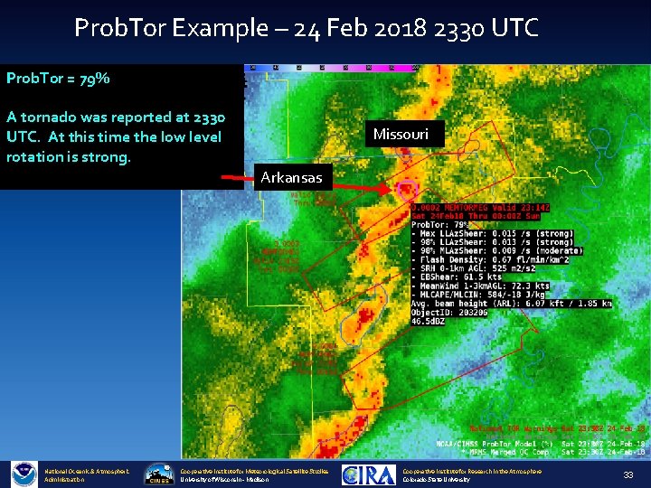
Prob. Tor Example – 24 Feb 2018 2330 UTC Prob. Tor = 79% A tornado was reported at 2330 UTC. At this time the low level rotation is strong. Missouri Arkansas National Oceanic & Atmospheric Administration Cooperative Institute for Meteorological Satellite Studies University of Wisconsin - Madison Cooperative Institute for Research in the Atmosphere Colorado State University 33
Validation National Oceanic & Atmospheric Administration Cooperative Institute for Meteorological Satellite Studies University of Wisconsin - Madison Cooperative Institute for Research in the Atmosphere Colorado State University 34
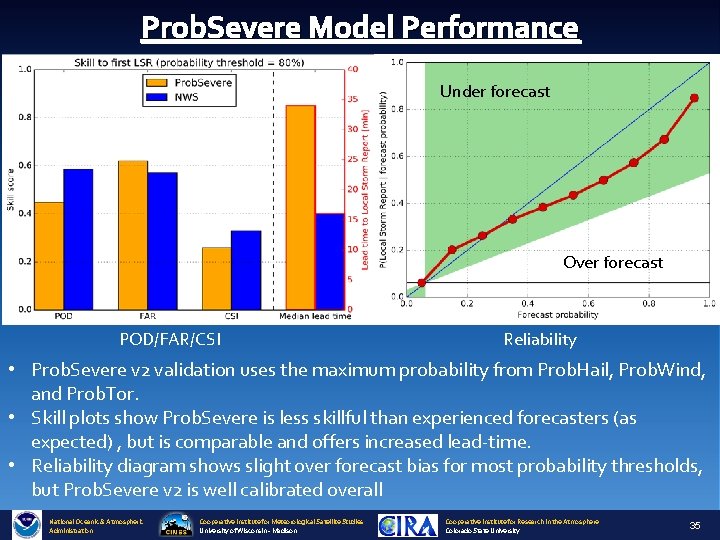
Prob. Severe Model Performance Under forecast Over forecast POD/FAR/CSI Reliability • Prob. Severe v 2 validation uses the maximum probability from Prob. Hail, Prob. Wind, and Prob. Tor. • Skill plots show Prob. Severe is less skillful than experienced forecasters (as expected) , but is comparable and offers increased lead-time. • Reliability diagram shows slight over forecast bias for most probability thresholds, but Prob. Severe v 2 is well calibrated overall National Oceanic & Atmospheric Administration Cooperative Institute for Meteorological Satellite Studies University of Wisconsin - Madison Cooperative Institute for Research in the Atmosphere Colorado State University 35
Prob. Severe – Hail Improvement • Prob. Hail Max CSI: 0. 43 vs Prob. Severe v 1 Max CSI (for hail): 0. 40 National Oceanic & Atmospheric Administration Cooperative Institute for Meteorological Satellite Studies University of Wisconsin - Madison Cooperative Institute for Research in the Atmosphere Colorado State University 36
Prob. Hail Reliability Under forecast Over forecast • Reliability analysis shows Prob. Hail is well calibrated, with a small over forecast bias for probabilities ≥ 40% and is significantly more reliable than Prob. Severe v 1. National Oceanic & Atmospheric Administration Cooperative Institute for Meteorological Satellite Studies University of Wisconsin - Madison Cooperative Institute for Research in the Atmosphere Colorado State University 37

Prob. Severe – Wind Improvement • Prob. Wind Max CSI: 0. 31 vs Prob. Severe v 1 Max CSI (for wind): 0. 26 National Oceanic & Atmospheric Administration Cooperative Institute for Meteorological Satellite Studies University of Wisconsin - Madison Cooperative Institute for Research in the Atmosphere Colorado State University 38
Prob. Wind Reliability Under forecast Over forecast • Reliability analysis shows Prob. Wind is well calibrated, with a small over forecast bias for probabilities ≥ 40% and is significantly more reliable than Prob. Severe v 1. National Oceanic & Atmospheric Administration Cooperative Institute for Meteorological Satellite Studies University of Wisconsin - Madison Cooperative Institute for Research in the Atmosphere Colorado State University 39
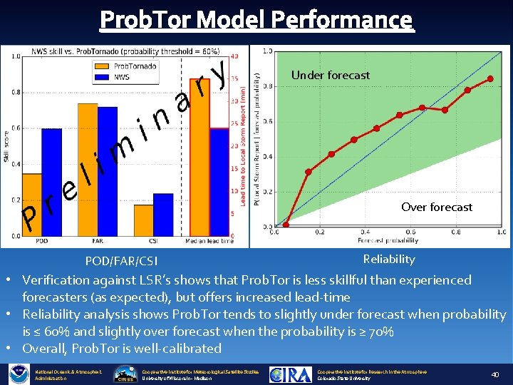
Prob. Tor Model Performance Under forecast Over forecast POD/FAR/CSI Reliability • Verification against LSR’s shows that Prob. Tor is less skillful than experienced forecasters (as expected), but offers increased lead-time • Reliability analysis shows Prob. Tor tends to slightly under forecast when probability is ≤ 60% and slightly over forecast when the probability is ≥ 70% • Overall, Prob. Tor is well-calibrated National Oceanic & Atmospheric Administration Cooperative Institute for Meteorological Satellite Studies University of Wisconsin - Madison Cooperative Institute for Research in the Atmosphere Colorado State University 40
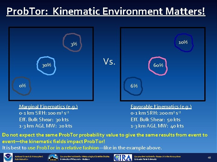
Prob. Tor: Kinematic Environment Matters! 10% 3% Vs. 30% 60% 0% 6% Marginal Kinematics (e. g. ) 0 -1 km SRH: 100 m 2 s-2 Eff. Bulk Shear: 30 kts 1 -3 km AGL MW: 20 kts Favorable Kinematics (e. g. ) 0 -1 km SRH: 200 m 2 s-2 Eff. Bulk Shear: 50 kts 1 -3 km AGL MW: 40 kts Do not expect the same Prob. Tor probability value to give the same results from event to event—the kinematic fields impact Prob. Tor! It is best to use Prob. Tor in a relative fashion—like in the example above. National Oceanic & Atmospheric Administration Cooperative Institute for Meteorological Satellite Studies University of Wisconsin - Madison Cooperative Institute for Research in the Atmosphere Colorado State University 41
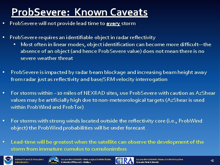
Prob. Severe: Known Caveats • Prob. Severe will not provide lead time to every storm • Prob. Severe requires an identifiable object in radar reflectivity • Most often in linear modes, object identification can become more difficult—the absence of an object (and hence Prob. Severe value) does not mean there is no severe weather threat • Prob. Severe is impacted by radar beam blockage and increasing beam height away from radar just as reflectivity and base/SRM velocity interrogation • For storms within ~10 miles of NEXRAD sites, use Prob. Severe with caution as Az. Shear values may be artificially high due t 0 non-meteorological targets (Az. Shear is used within Prob. Wind and Prob. Tor) • For storms with strong winds located outside the reflectivity core (i. e. , Prob. Wind object) the Prob. Wind probabilities will be under forecast • Lead-time will be greatest when the satellite can observe the development of the storm from immature cumulus to cumulonimbus National Oceanic & Atmospheric Administration Cooperative Institute for Meteorological Satellite Studies University of Wisconsin - Madison Cooperative Institute for Research in the Atmosphere Colorado State University 42
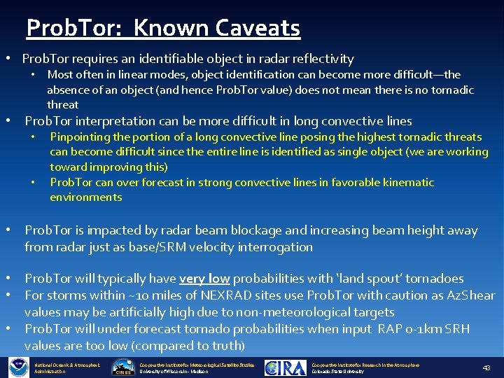
Prob. Tor: Known Caveats • Prob. Tor requires an identifiable object in radar reflectivity • Most often in linear modes, object identification can become more difficult—the absence of an object (and hence Prob. Tor value) does not mean there is no tornadic threat • Prob. Tor interpretation can be more difficult in long convective lines • • Pinpointing the portion of a long convective line posing the highest tornadic threats can become difficult since the entire line is identified as single object (we are working toward improving this) Prob. Tor can over forecast in strong convective lines in favorable kinematic environments • Prob. Tor is impacted by radar beam blockage and increasing beam height away from radar just as base/SRM velocity interrogation • Prob. Tor will typically have very low probabilities with ‘land spout’ tornadoes • For storms within ~10 miles of NEXRAD sites use Prob. Tor with caution as Az. Shear values may be artificially high due t 0 non-meteorological targets • Prob. Tor will under forecast tornado probabilities when input RAP 0 -1 km SRH values are too low (compared to truth) National Oceanic & Atmospheric Administration Cooperative Institute for Meteorological Satellite Studies University of Wisconsin - Madison Cooperative Institute for Research in the Atmosphere Colorado State University 43
Prob. Severe: Summary • Prob. Severe is a statistical model that incorporates NWP fields, radar observations, and total lightning observations to predict the probability a storm will produce a severe weather (or a specific hazard if using the hazard models) in the next 0 -60 minutes. • All Prob. Severe v 2 models should be used in combination with existing radar interrogation techniques and is designed to increase forecaster confidence and increase lead-time • Prob. Tor is best used in a relative sense—how a storm’s values compare to neighbors since the kinematic environment will impact probabilities in addition to observations (the ‘best’ probability threshold will change based on the environment). • Prob. Tor is fairly well-calibrated; so a storm with a 33% probability will produce a tornado about 1 in 3 times and so on. • Prob. Tor values will fluctuate in response to changes in strength of storm rotation and storm updraft. • GOES-R GLM is not yet incorporated in Prob. Severe—but work continues toward including GLM National Oceanic & Atmospheric Administration Cooperative Institute for Meteorological Satellite Studies University of Wisconsin - Madison Cooperative Institute for Research in the Atmosphere Colorado State University 44
Contact and References • Mike Pavolonis (michael. pavolonis@noaa. gov) • John Cintineo (john. cintineo@ssec. wisc. edu) • Justin Sieglaff (justin. sieglaff@ssec. wisc. edu) • Dan Lindsey (dan. lindsey@noaa. gov) To access this training online and access supplement training please see: http: //cimss. ssec. wisc. edu/severe_conv/training. html Prob. Severe All Hazards is also available on the web in real-time: http: //cimss. ssec. wisc. edu/severe_conv/probsevtest. html Prob. Tor is also available on the web in real-time: http: //cimss. ssec. wisc. edu/severe_conv/probtor. html Key References: https: //journals. ametsoc. org/doi/full/10. 1175/WAF-D-17 -0099. 1 https: //journals. ametsoc. org/doi/full/10. 1175/WAF-D-13 -00113. 1 National Oceanic & Atmospheric Administration Cooperative Institute for Meteorological Satellite Studies University of Wisconsin - Madison Cooperative Institute for Research in the Atmosphere Colorado State University 45
- Slides: 45