NOAA Hurricane Forecast Improvement Project Frank Marks NOAA


- Slides: 36

NOAA Hurricane Forecast Improvement Project Frank Marks NOAA HFIP Lead Director, NOAA/AOML Hurricane Research Division 16 February 2010

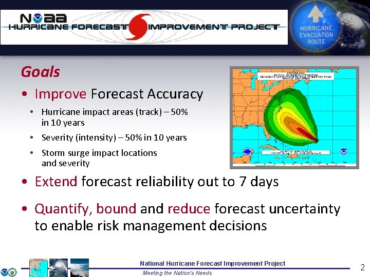
Goals • Improve Forecast Accuracy • Hurricane impact areas (track) – 50% in 10 years • Severity (intensity) – 50% in 10 years • Storm surge impact locations and severity • Extend forecast reliability out to 7 days • Quantify, bound and reduce forecast uncertainty to enable risk management decisions National Hurricane Forecast Improvement Project Meeting the Nation’s Needs 2

How to get there? Ø Science • • • Improved understanding from combination of observations & models Higher resolution coupled models – critical to storm evolution forecasts – especially intensity changes Forecast techniques to understand, reduce &communicate uncertainty Ø Information Technology • • Increased computing power - run advanced hurricane/global models and reduce uncertainty IT infrastructure for inter-agency data exchange Ø Observing Strategy • Improved use of existing and planned systems Ø Improved Products for Forecasters National Hurricane Forecast Improvement Project Meeting the Nation’s Needs 3

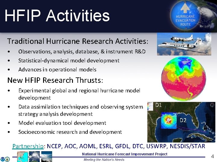
HFIP Activities Traditional Hurricane Research Activities: • • • Observations, analysis, database, & instrument R&D Statistical-dynamical model development Advances in operational models New HFIP Research Thrusts: • • Experimental global and regional hurricane model development Data assimilation techniques and observing system strategy analysis development Model evaluation tool development Socioeconomic research and development D 1 D 2 Partnership: NCEP, AOC, AOML, ESRL, GFDL, DTC, USWRP, NESDIS/STAR National Hurricane Forecast Improvement Project Meeting the Nation’s Needs 4

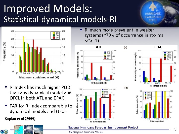
Improved Models: Statistical-dynamical models-RI • RI much more prevalent in weaker systems (~70% of occurrence in storms <Cat 1) ATL EPAC • RI Index has much higher POD than any dynamical model and OFCL in both ATL and EPAC • FAR for RI index comparable to dynamical models and OFCL Kaplan et al (2009) National Hurricane Forecast Improvement Project Meeting the Nation’s Needs 5

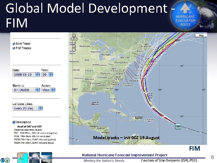
Global Model Development FIM Model tracks – init 00 Z 19 August FIM National Hurricane Forecast Improvement Project Courtesy of Stan Benjamin (ESRL/PSD) Meeting the Nation’s Needs 6

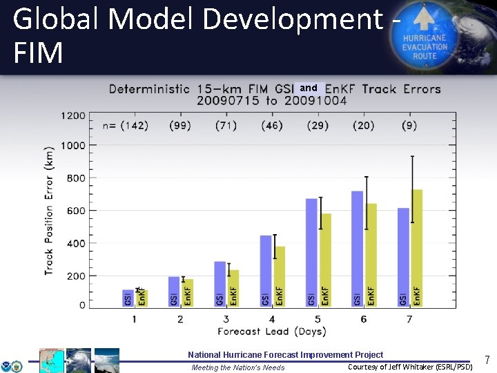
Global Model Development FIM and National Hurricane Forecast Improvement Project Courtesy of Jeff Whitaker (ESRL/PSD) Meeting the Nation’s Needs 7

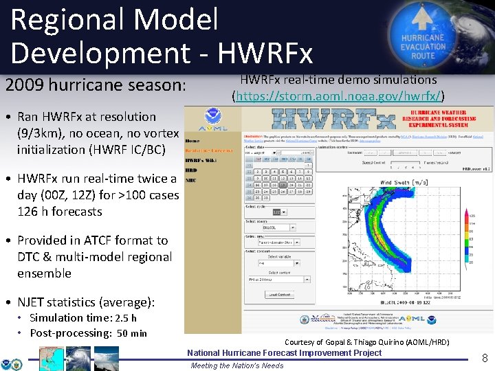
Regional Model Development - HWRFx 2009 hurricane season: HWRFx real-time demo simulations (https: //storm. aoml. noaa. gov/hwrfx/) • Ran HWRFx at resolution (9/3 km), no ocean, no vortex initialization (HWRF IC/BC) • HWRFx run real-time twice a day (00 Z, 12 Z) for >100 cases 126 h forecasts • Provided in ATCF format to DTC & multi-model regional ensemble • NJET statistics (average): • Simulation time: 2. 5 h • Post-processing: 50 min Courtesy of Gopal & Thiago Quirino (AOML/HRD) National Hurricane Forecast Improvement Project Meeting the Nation’s Needs 8

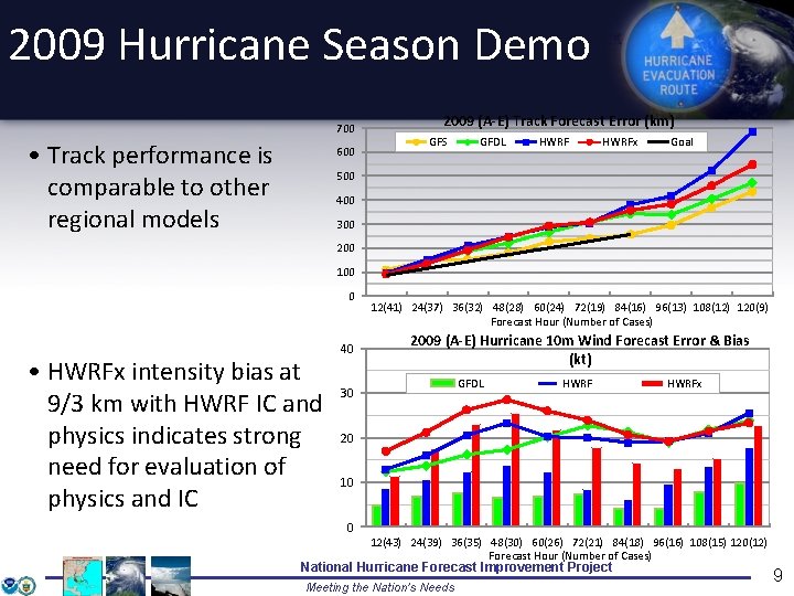
2009 Hurricane Season Demo 700 • Track performance is comparable to other regional models 600 2009 (A-E) Track Forecast Error (km) GFS GFDL HWRFx Goal 500 400 300 200 100 0 • HWRFx intensity bias at 9/3 km with HWRF IC and physics indicates strong need for evaluation of physics and IC 40 12(41) 24(37) 36(32) 48(28) 60(24) 72(19) 84(16) 96(13) 108(12) 120(9) Forecast Hour (Number of Cases) 2009 (A-E) Hurricane 10 m Wind Forecast Error & Bias (kt) GFDL 30 HWRFx 20 10 0 12(43) 24(39) 36(35) 48(30) 60(26) 72(21) 84(18) 96(16) 108(15) 120(12) Forecast Hour (Number of Cases) National Hurricane Forecast Improvement Project Meeting the Nation’s Needs 9

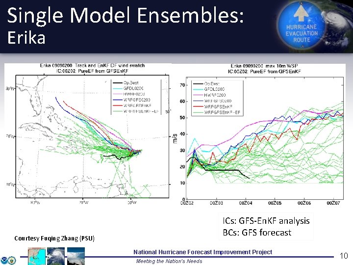
Single Model Ensembles: Erika ICs: GFS-En. KF analysis BCs: GFS forecast Courtesy Fuqing Zhang (PSU) National Hurricane Forecast Improvement Project Meeting the Nation’s Needs 10

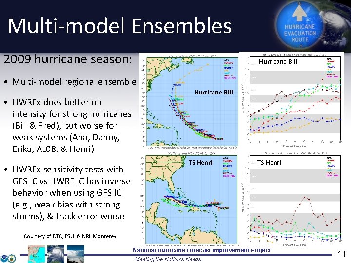
Multi-model Ensembles 2009 hurricane season: Hurricane Bill • Multi-model regional ensemble • HWRFx does better on intensity for strong hurricanes (Bill & Fred), but worse for weak systems (Ana, Danny, Erika, AL 08, & Henri) • HWRFx sensitivity tests with GFS IC vs HWRF IC has inverse behavior when using GFS IC (e. g. , weak bias with strong storms), & track error worse Hurricane Bill TS Henri Courtesy of DTC, FSU, & NRL Monterey National Hurricane Forecast Improvement Project Meeting the Nation’s Needs 11

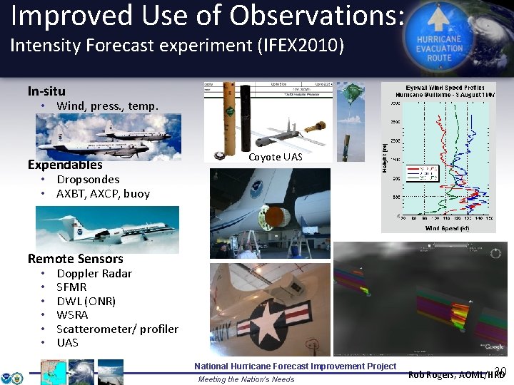
Improved Use of Observations: Intensity Forecast experiment (IFEX) In-situ • Wind, press. , temp. Expendables Coyote UAS • Dropsondes • AXBT, AXCP, buoy Remote Sensors • • • Doppler Radar SFMR DWL (ONR) WSRA Scatterometer/ profiler UAS National Hurricane Forecast Improvement Project Meeting the Nation’s Needs Rob Rogers, AOML/HRD 12

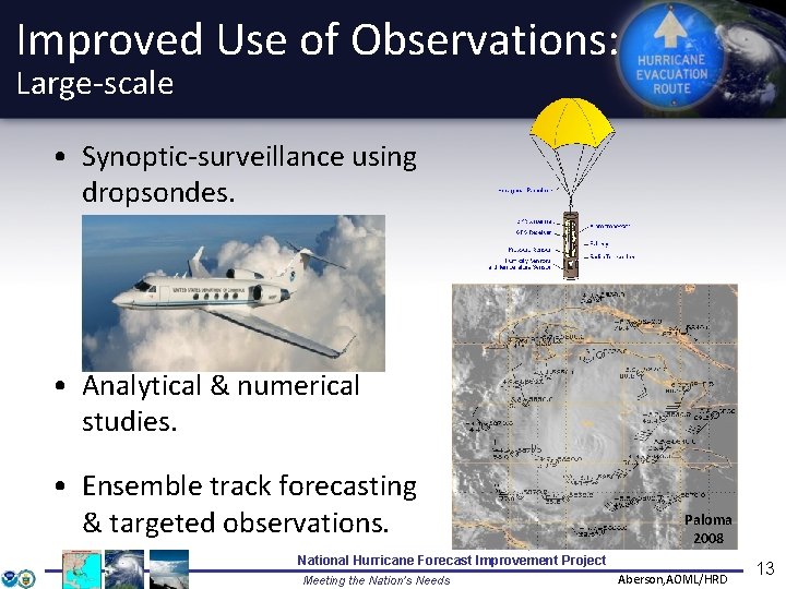
Improved Use of Observations: Large-scale • Synoptic-surveillance using dropsondes. • Analytical & numerical studies. • Ensemble track forecasting & targeted observations. Paloma 2008 National Hurricane Forecast Improvement Project Meeting the Nation’s Needs Aberson, AOML/HRD 13

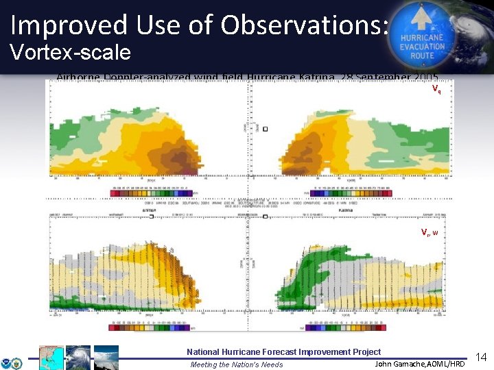
Improved Use of Observations: Vortex-scale Airborne Doppler-analyzed wind field Hurricane Katrina, 28 September 2005 Vq Vr, w National Hurricane Forecast Improvement Project John Gamache, AOML/HRD Meeting the Nation’s Needs 14

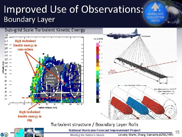
Improved Use of Observations: Boundary Layer Sub-grid Scale Turbulent Kinetic Energy Altitude (km) High turbulent kinetic energy in convection Low turbulent kinetic energy Radial Distance (km) High turbulent kinetic energy in PBL Turbulent structure / Boundary Layer Rolls National Hurricane Forecast Improvement Project Lorsolo, Marks, Zhang, Gamache, AOML/HRD Meeting the Nation’s Needs 15

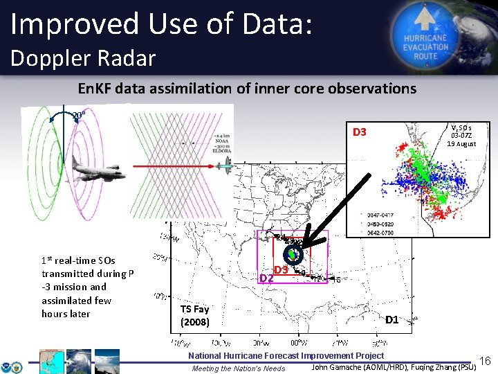
Improved Use of Data: Doppler Radar En. KF data assimilation of inner core observations 20° Vr SOs 03 -07 Z 19 August D 3 1 st real-time SOs transmitted during P -3 mission and assimilated few hours later D 2 TS Fay (2008) D 3 D 1 National Hurricane Forecast Improvement Project 16 John Gamache (AOML/HRD), Fuqing Zhang (PSU) Meeting the Nation’s Needs

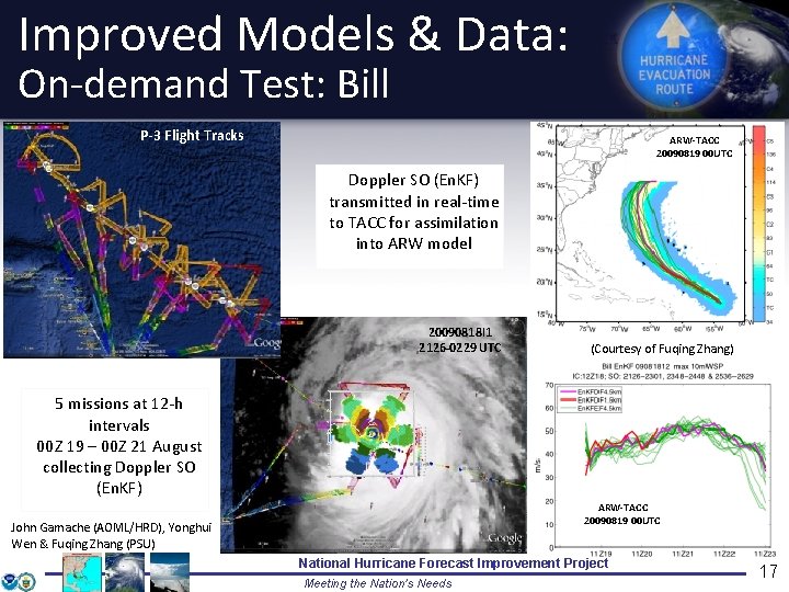
Improved Models & Data: On-demand Test: Bill P-3 Flight Tracks ARW-TACC 20090819 00 UTC Doppler SO (En. KF) transmitted in real-time to TACC for assimilation into ARW model 20090818 I 1 2126 -0229 UTC (Courtesy of Fuqing Zhang) 5 missions at 12 -h intervals 00 Z 19 – 00 Z 21 August collecting Doppler SO (En. KF) ARW-TACC 20090819 00 UTC John Gamache (AOML/HRD), Yonghui Wen & Fuqing Zhang (PSU) National Hurricane Forecast Improvement Project Meeting the Nation’s Needs 17

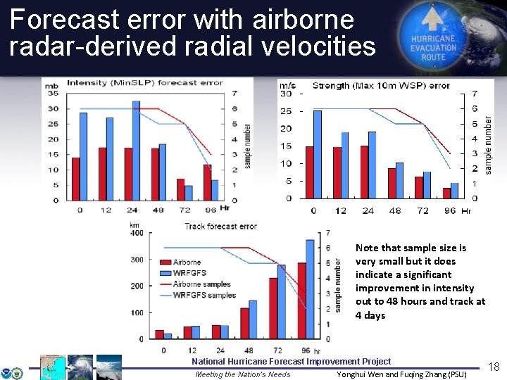
Forecast error with airborne radar-derived radial velocities Note that sample size is very small but it does indicate a significant improvement in intensity out to 48 hours and track at 4 days National Hurricane Forecast Improvement Project Meeting the Nation’s Needs Yonghui Wen and Fuqing Zhang (PSU) 18

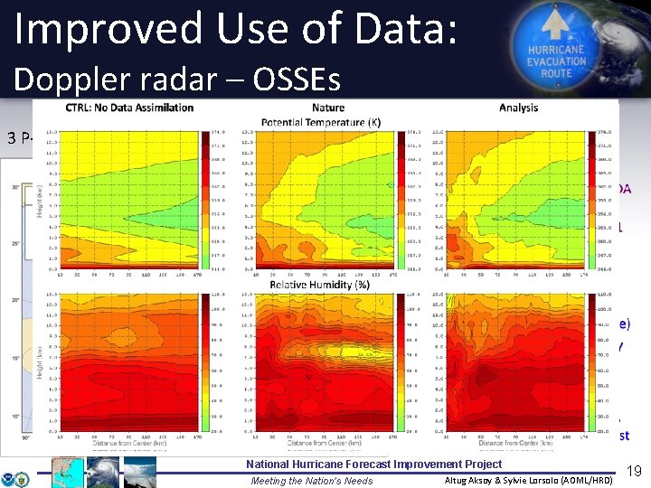
Improved Use of Data: Doppler radar – OSSEs Test storm: Hurricane Paloma, 7 -9 Nov. 2008 3 P-3 (red, green, black) and 2 G-IV flights during RI) 07 -12 Z: 75 kt 09 -12 Z: 35 kt 08 -12 Z: 125 kt National Hurricane Forecast Improvement Project Meeting the Nation’s Needs Altug Aksoy & Sylvie Lorsolo (AOML/HRD) 19

Improved Use of Observations: Model evaluation • Critical to HFIP success: Massive amounts of simulation output: • High-res hurricane (HRH) test: 69 cases for 6 -7 model teams - 50 Tb • 2008 & 2009 HFIP Real-time test – >100 cases plus multi-model regional ensembles • Tools needed to evaluate more than track and peak wind (e. g. , largescale, vortex-scale, convective scale, probability) • Milestones: • Develop & test HWRF and FIM large-scale evaluation tools (track, DLM, shear, SHIPS & RI diagnostics) • Develop & test HWRF vortex-scale evaluation tools (storm-centered diagnostics, e. g. , R-Z mean, Hovmöller, wavenumber, wind radii, IKE) • Develop & test convective-scale evaluation tools (CFADs, mass flux, latent heat distribution, microphysics, water mass, precipitation, reflectivity, satellite T b) • Hurricane Data Warehouse (observations, model simulations, etc. ) National Hurricane Forecast Improvement Project Meeting the Nation’s Needs Rob Rogers, Gopal, Thiago Quirino AOML/HRD 20

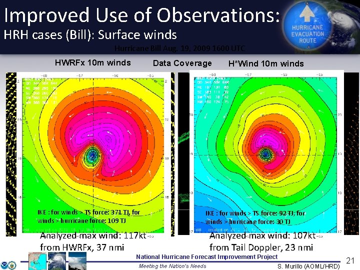
Improved Use of Observations: HRH cases (Bill): Surface winds Hurricane Bill Aug. 19, 2009 1600 UTC HWRFx 10 m winds Data Coverage IKE : for winds > TS force: 371 TJ, for winds > hurricane force: 109 TJ H*Wind 10 m winds IKE : for winds > TS force: 92 TJ, for winds > hurricane force: 30 TJ Analyzed max wind: 117 kt from HWRFx, 37 nmi Analyzed max wind: 107 kt from Tail Doppler, 23 nmi National Hurricane Forecast Improvement Project Meeting the Nation’s Needs S. Murillo (AOML/HRD) 21

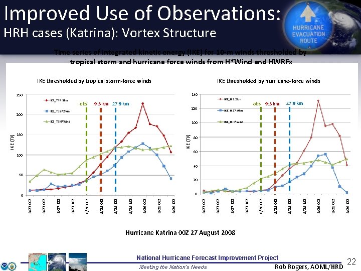
Improved Use of Observations: HRH cases (Katrina): Vortex Structure Time series of integrated kinetic energy (IKE) for 10 -m winds thresholded by tropical storm and hurricane force winds from H*Wind and HWRFx IKE thresholded by tropical storm-force winds IKE thresholded by hurricane-force winds 140 250 obs 9: 3 km 27: 9 km obs 9: 3 km 120 27: 9 km 200 150 IKE (TJ) IKE 100 80 60 40 50 20 8/29 12 Z 8/29 06 Z 8/29 00 Z 8/28 18 Z 8/28 12 Z 8/28 06 Z 8/28 00 Z 8/27 18 Z 8/27 12 Z 8/27 06 Z 8/27 00 Z 0 0 8/27 00 Z IKE (TJ) 100 Hurricane Katrina 00 Z 27 August 2008 National Hurricane Forecast Improvement Project Meeting the Nation’s Needs Rob Rogers, AOML/HRD 22

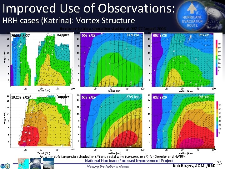
Improved Use of Observations: HRH cases (Katrina): Vortex Structure Hurricane Katrina simulation starting at 00 Z 27 August 2008 16 height (km) 14 14 16 27: 9 km 00 Z 8/28 14 12 12 12 10 10 10 8 8 8 6 6 6 4 4 4 2 25 16 14 height (km) 16 Doppler 20: 08 Z 8/27 50 radius (km) 75 100 16 Doppler 19: 23 Z 8/28 25 14 50 radius (km) 75 100 25 16 27: 9 km 03 Z 8/29 14 12 12 12 10 10 10 8 8 8 6 6 6 4 4 4 2 25 50 radius (km) 75 100 25 50 75 radius (km) 100 9: 3 km 00 Z 8/28 50 radius (km) 50 75 100 radius (km) Axisymmetric tangential (shaded, m s -1) and radial wind (contour, m s-1) for Doppler and HWRFx National Hurricane Forecast Improvement Project Meeting the Nation’s Needs 100 9: 3 km 03 Z 8/29 25 75 Rob Rogers, AOML/HRD 23

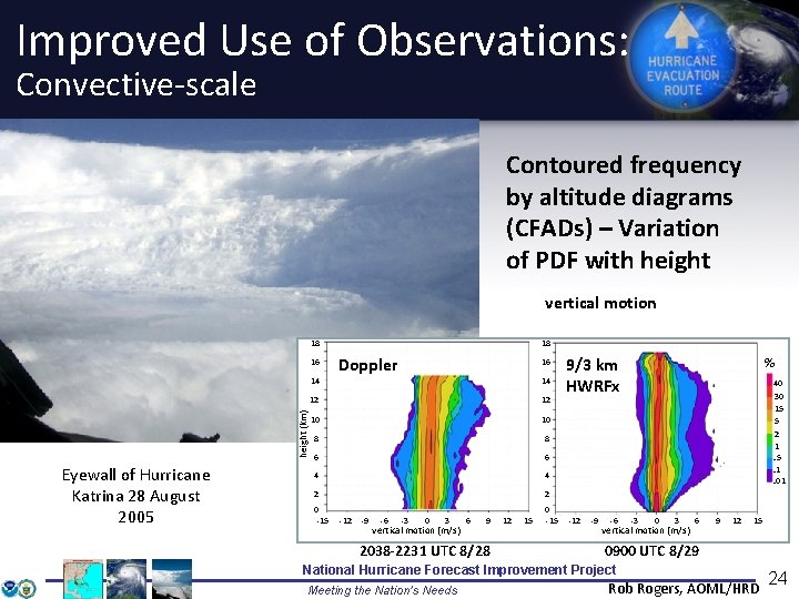
Improved Use of Observations: Convective-scale Contoured frequency by altitude diagrams (CFADs) – Variation of PDF with height vertical motion 18 16 height (km) 14 Eyewall of Hurricane Katrina 28 August 2005 18 Doppler 16 14 12 12 10 10 8 8 6 6 4 4 2 2 0 -15 -12 -9 -6 -3 0 3 vertical motion (m/s) 6 9 2038 -2231 UTC 8/28 12 15 9/3 km HWRFx % 40 30 15 5 2 1. 5. 1. 01 -12 -9 -6 -3 0 3 vertical motion (m/s) 6 9 12 15 0900 UTC 8/29 National Hurricane Forecast Improvement Project Meeting the Nation’s Needs Rob Rogers, AOML/HRD 24

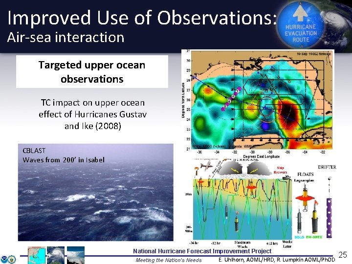
Improved Use of Observations: Air-sea interaction Targeted upper ocean observations TC impact on upper ocean effect of Hurricanes Gustav and Ike (2008) CBLAST Waves from 200’ in Isabel National Hurricane Forecast Improvement Project E. Uhlhorn, AOML/HRD, R. Lumpkin AOML/Ph. OD Meeting the Nation’s Needs 25

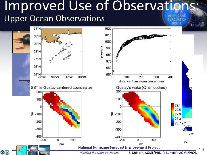
Improved Use of Observations: Upper Ocean Observations Array of Minimet and ADOS Post-storm Ocean Survey (thermistor chain) drifters deployed in. Gustav front of& Ike (2008) Hurricanes Gustav & Ike 2008. 080915 I 56 (61) AXBTs 8. 0 hrs Upper Ocean Heat Content National Hurricane Forecast Improvement Project E. Uhlhorn, AOML/HRD, R. Lumpkin AOML/Ph. OD Meeting the Nation’s Needs 26

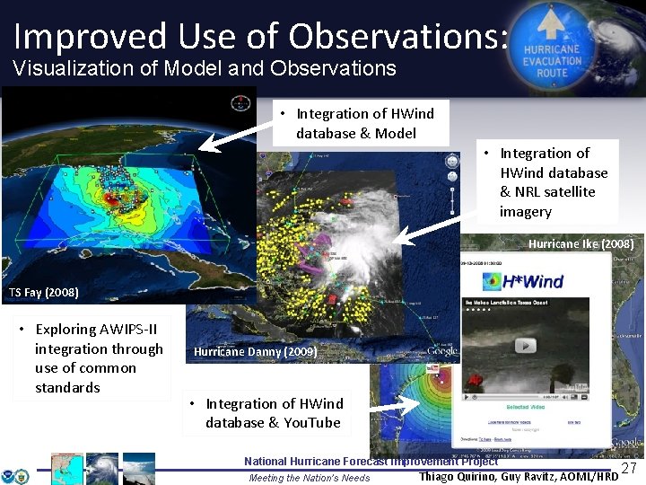
Improved Use of Observations: Visualization of Model and Observations • Integration of HWind database & Model • Integration of HWind database & NRL satellite imagery Hurricane Ike (2008) TS Fay (2008) • Exploring AWIPS-II integration through use of common standards Hurricane Danny (2009) • Integration of HWind database & You. Tube National Hurricane Forecast Improvement Project Meeting the Nation’s Needs Thiago Quirino, Guy Ravitz, AOML/HRD 27

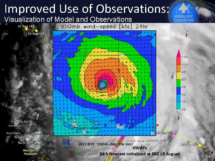
Improved Use of Observations: Visualization of Model and Observations Observed 00 Z 20 August 20090819 I 2 2137 -0224 UTC HWRFx National Hurricane Forecast Improvement Project 24 h forecast initialized at 00 Z 19 August Meeting the Nation’s Needs 28

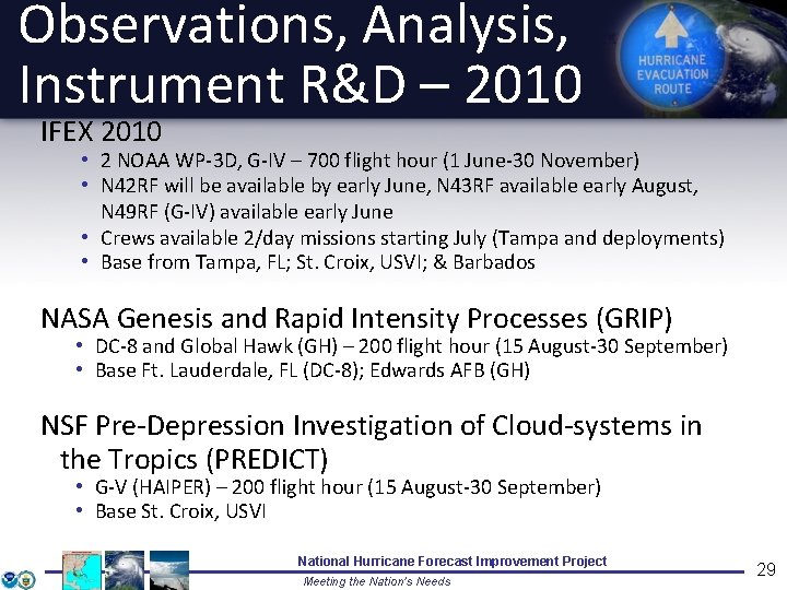
Observations, Analysis, Instrument R&D – 2010 IFEX 2010 • 2 NOAA WP-3 D, G-IV – 700 flight hour (1 June-30 November) • N 42 RF will be available by early June, N 43 RF available early August, N 49 RF (G-IV) available early June • Crews available 2/day missions starting July (Tampa and deployments) • Base from Tampa, FL; St. Croix, USVI; & Barbados NASA Genesis and Rapid Intensity Processes (GRIP) • DC-8 and Global Hawk (GH) – 200 flight hour (15 August-30 September) • Base Ft. Lauderdale, FL (DC-8); Edwards AFB (GH) NSF Pre-Depression Investigation of Cloud-systems in the Tropics (PREDICT) • G-V (HAIPER) – 200 flight hour (15 August-30 September) • Base St. Croix, USVI National Hurricane Forecast Improvement Project Meeting the Nation’s Needs 29

Improved Use of Observations: Intensity Forecast experiment (IFEX 2010) In-situ • Wind, press. , temp. Expendables Coyote UAS • Dropsondes • AXBT, AXCP, buoy Remote Sensors • • • Doppler Radar SFMR DWL (ONR) WSRA Scatterometer/ profiler UAS National Hurricane Forecast Improvement Project Meeting the Nation’s Needs 30 Rob Rogers, AOML/HRD

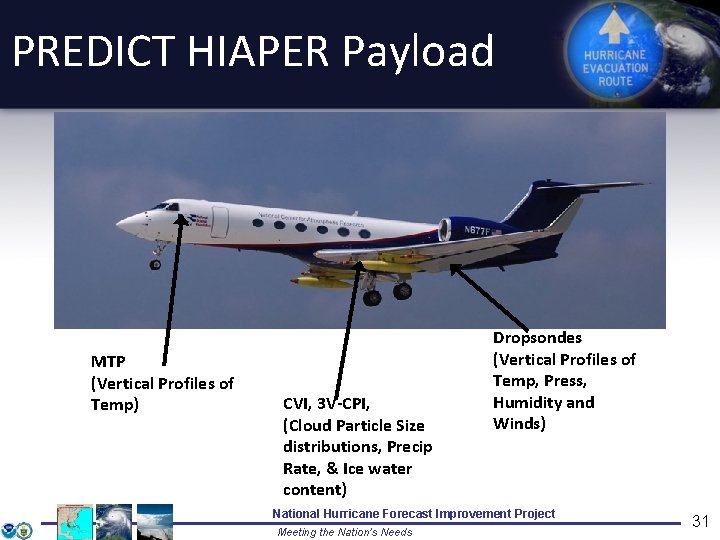
PREDICT HIAPER Payload MTP (Vertical Profiles of Temp) CVI, 3 V-CPI, (Cloud Particle Size distributions, Precip Rate, & Ice water content) Dropsondes (Vertical Profiles of Temp, Press, Humidity and Winds) National Hurricane Forecast Improvement Project Meeting the Nation’s Needs 31

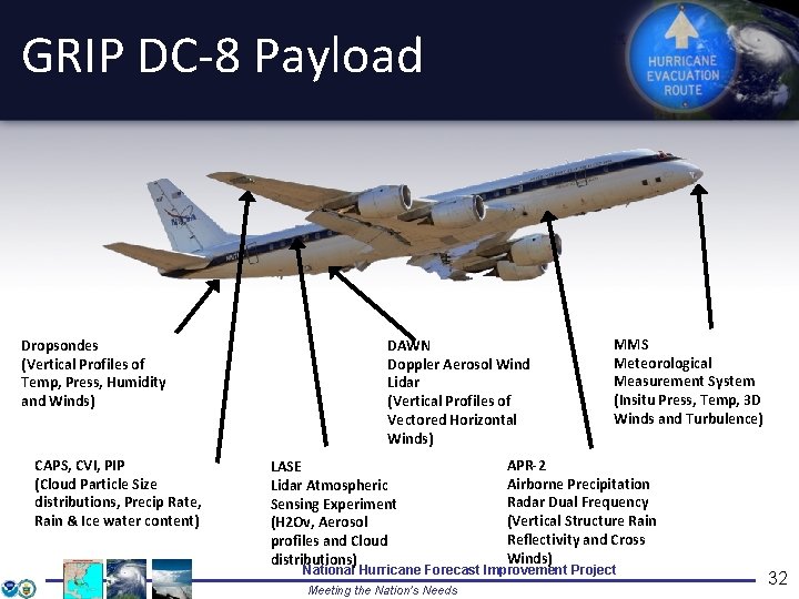
GRIP DC-8 Payload Dropsondes (Vertical Profiles of Temp, Press, Humidity and Winds) CAPS, CVI, PIP (Cloud Particle Size distributions, Precip Rate, Rain & Ice water content) DAWN Doppler Aerosol Wind Lidar (Vertical Profiles of Vectored Horizontal Winds) LASE Lidar Atmospheric Sensing Experiment (H 2 Ov, Aerosol profiles and Cloud distributions) MMS Meteorological Measurement System (Insitu Press, Temp, 3 D Winds and Turbulence) APR-2 Airborne Precipitation Radar Dual Frequency (Vertical Structure Rain Reflectivity and Cross Winds) National Hurricane Forecast Improvement Project Meeting the Nation’s Needs 32

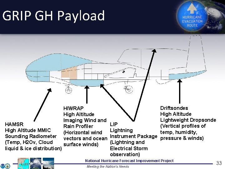
GRIP GH Payload HAMSR High Altitude MMIC Sounding Radiometer (Temp, H 2 Ov, Cloud liquid & ice distribution) 33 HIWRAP High Altitude Imaging Wind and Rain Profiler (Horizontal wind vectors and ocean surface winds) Driftsondes High Altitude Lightweight Dropsonde LIP (Vertical profiles of Lightning temp, humidity, Instrument Package pressure & winds) (Lightning and Electrical Storm observation) National Hurricane Forecast Improvement Project Meeting the Nation’s Needs 33

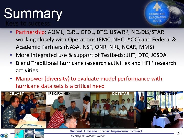
Summary Keys to success: • Partnership: AOML, ESRL, GFDL, DTC, USWRP, NESDIS/STAR working closely with Operations (EMC, NHC, AOC) and Federal & Academic Partners (NASA, NSF, ONR, NRL, NCAR, MMS) • More integrated use & support of Testbeds: JHT, DTC, JCSDA • Blend Traditional hurricane research activities and HFIP research activities • Manpower (diversity) to evaluate model performance with hurricane data sets is a critical need CBLAST IFEX/RAINEX DOTSTAR National Hurricane Forecast Improvement Project Meeting the Nation’s Needs IFEX/TCSP 34

Questions?

High Performance Computing Augmentations 2008 • 15 M Hours – Texas Area Computing Center 2009 • NJET Boulder ~2 MHours/month starting 9/2009 • TACC – HFIP 20 M Hours 7/1 – 12/31 • TACC Penn State 13 M Hours for High Resolution ARW Ensembles and Data Assimilation • 115 K Hours/month on NOAA R&D Computer in Gaithersburg • NCEP backup computer (Cirrus) for HWRF testing 2010 - Planned • • NJET ~2 M Hours/month DOE ORNL Jaguar - 20 M hours TACC – 2. 5 M hours 1/1 – 6/30 ~+3000 Processors on NJET beginning 7/1/2010 National Hurricane Forecast Improvement Project Meeting the Nation’s Needs 36