News http www dailyfueleconomytip comcreativeideasgpssystemscancutyourcarbonfootprintandyourcommute http news bbc

News • http: //www. dailyfueleconomytip. com/creative-ideas/gpssystems-can-cut-your-carbon-footprint-and-yourcommute/ • http: //news. bbc. co. uk/2/hi/middle_east/8302161. stm • http: //www. treehugger. com/files/2009/10/coal-plantsdump-thousands-gallons-waste-drinking-waterday. php? dcitc=th_rss • http: //rawstory. com/2009/10/bush-administration-covered -up-epa-global-warming-finding-email-reveals/ • http: //www. nytimes. com/2009/10/15/business/energyenvironment/15 degrees. html? _r=2&hp • http: //www. boston. com/lifestyle/green/articles/2009/10/1 5/mass_waterway_members_resign_over_safety_issues /

What features do you notice? Images removed due to copyright restrictions.

Images removed due to copyright restrictions.

Features

Observations • • • Earth is 71% under water Mountain ranges are long lines Mid-Ocean ridges are long arcs Trenches Seamounts Flat portions of the earth – Continental shelves – Ocean bottom
 Earth's hypsography")
Hypsographic Curve 2005 -07 -01 13: 46 Zyzzy 1040× 530× (40680 bytes) Earth's hypsography {{cc-by 2. 0}}

Images removed due to copyright restrictions.

Plate Tectonics • Two types of crust – Oceanic – Continental • Convective Mantle (plates move) – Magnetic Anomalies – Hot Spots • Plate Boundaries – Convergent – Divergent – Transform

Plate Tectonics Is Responsible Image courtesy of United States Geological Survey Drawing modified from Montgomery: Environmental Geology; © 2002, Mc. Graw Hill

Geologic Processes: Structure of the Earth Image courtesy of Wikipedia under Creative Commons license Fig. 4 -7 p. 60

Plate Tectonics Ø Divergent boundary Ø Convergent boundary Image courtesy of United States Geological Survey Ø Subduction zone Ø Transform fault Fig. 16 -5 p. 336 Refer to Fig. 16 -3 p. 334

Image courtesy of United States Geological Survey

Magnetic Anomalies Images removed due to copyright restrictions.

Convergent Plate Boundaries Continent-Ocean Image courtesy of Wikipedia Fig. 16 -2 p. 333

Image courtesy of Wikipedia Convergent: Ocean-Ocean

Convergent: Continent-Continent Image courtesy of Wikipedia

Transform Fault Image courtesy of U. S. Geological Survey

Transform Fault Image courtesy of Lamont-Doherty Earth Observatory of Columbia University

Earth’s Major Tectonic Plates Source: USGS Fig. 16 -4, p. 335

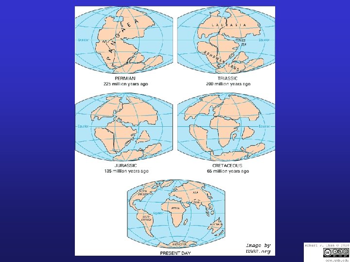
Pangaea http: //en. wikipedia. org/wiki/Image: Pa ngea_animation_03. gif Images removed due to copyright restrictions.

Ring of Fire

Hot Spot Volcanoes Image courtesy of U. S. Geological Survey

Images removed due to copyright restrictions.

Earth’s Major Tectonic Plates Image courtesy of U. S. Geological Survey Fig. 16 -4, p. 335

Hydrothermal Vents Image courtesy of U. S. National Oceanic and Atmospheric Administration

Black smoker White smoker Sulfide deposit Images removed due to copyright restrictions. Magma Tube worms White crab White clam

Hydrothermal Vents Image courtesy of U. S. National Oceanic and Atmospheric Administration


Images removed due to copyright restrictions.

External Earth Processes Ø Erosion Ø Mechanical weathering Ø Frost wedging Ø Chemical weathering Ø Biological weathering

Natural Hazards: Volcanic Eruptions Image courtesy of U. S. Geological Survey Fig. 16 -8 p. 338
 Rock Types Ø Igneous (granite, basalt) Ø")
Minerals and Rocks Ø Mineral (diamond, quartz) Rock Types Ø Igneous (granite, basalt) Ø Sedimentary (limestone, sandstone) Ø Metamorphic (marble, slate)

Transport Erosion Deposition Rock Cycle Weathering Igneous Rock Granite, Pumice, Basalt Sedimentary Rock Shale, Sandstone, Limestone Heat, Pressure Heat, Metamorphic Rock Pressure Slate, Quartzite, Marble Magma (Molten Rock) Fig. 16 -9 p. 339

Supplies of Mineral Resources Ø Economic depletion Ø Depletion time Ø Foreign sources Ø Environmental concerns Images removed due to copyright restrictions. Ø Economics Ø New technologies Ø Mining the ocean Ø Finding substitutes Fig. 16 -16 p. 346
- Slides: 35