New Technology Developments for Increased Maritime Domain Awareness


: 2012 Yr 3 Operational Test Fully-automated, renewable (solar and wind)")


- Slides: 20
New Technology Developments for Increased Maritime Domain Awareness In the Chukchi Sea Hank Statscewich and Tom Weingartner USCG Debrief Juneau, AK July 27, 2012 Presented by Hank Statscewich University of Alaska Fairbanks
Objectives Provide overview of UAF Arctic Ocean Observing Activities n Increase US Arctic MDA with new technologies n Inform CG of synergistic partnerships n Collaborate and Integrate data streams within an Arctic COP n n SAROPS n Spill Response n Homeland Security
New York Times July 21, 2012 CNN May 24, 2012 Washington Post July 16, 2012
Scientific Mission Study area IOOSAOOS Glider survey line ~1. 0 Sv mean transport through Bering Strait Exchange with the Arctic proper is not well known. Schematic advection pathways, but details are largely missing
37 Underwater Moorings
Alongshore Crossshore Wind speed October 2010 storm event Year-long along-canyon velocities
Above: Webb Slocum G 2 glider after a 2. 5 month mission AUV operations in 2010 and 2011 using 3 Webb Slocum gliders performing > 6000 km of track length, collecting >20, 000 CTD profiles. All are equipped with optical sensors for sampling hydrocarbon/CDOM and chlorophyll Longest single mission duration 2. 5 months using lithium batteries. Small 30’ fast local landing vessel for deployments and recoveries. Sea-ice melt water, strong coastal jets and biology can be challenging… Above: Deploying gliders of the 32’ vessel “Tukpuk”, Wainwright, Alaska
1. Warm, moderately salty water from Bering Strait 2. Cold, salty winter water (local and remotely formed) 3. Cold, fresh surface water from ice melt 1 3 1 2
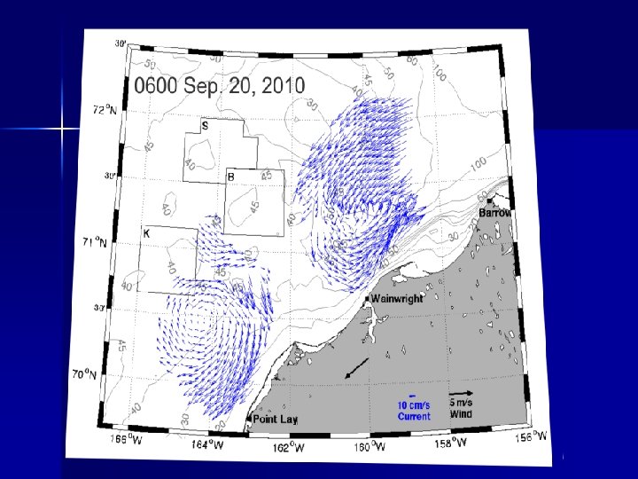
CODAR HF Radar Hourly 2 -D current vectors over ~200 km offshore. Operated 5 units 2009 -2011 in remote Arctic Alaskan regions (Barrow, Wainwright and Point Lay) from June to October.
Two main circulation modes: Four-day average HF radar surface current vectors Divergent mode Continuous (reversed)
Operational Difficulties: ? ? ? • Shore-based AC power • Sub-optimal coverage • Consumes ~8 k. WH/day • Permitting • Maintenance • Logistics Percent Coverage Shore-based power available Solution: Develop an autonomous power supply The Remote Power Module (RPM)
Remote Power Module (RPM): 2012 Yr 3 Operational Test Fully-automated, renewable (solar and wind) hybrid power station provide power & coms to HF radars. Designed to operate in arctic and sub-arctic maritime environments.
Point Barrow
Vessel Traffic Identified by AIS
Simulated HF Radar Derived Ship Detections Range, Range Rate and Bearing
Point Barrow Modis July 23, 2012 Image
Future Direction Example Radar Mask: 8 Long-Range HF-RPM systems Coverage: 800 km x 175 km = 1. 4 x 10⁶ km 2 2013 HFR Coverage Map Icy Cape Pt. Franklin Pt. Barrow Industry Oliktok & State (CIAP) Funded Barter Demarcation Cape Flaxman Halkett Pt. Is. Bay
Synergistic Activities 1. 2. 3. 4. 5. AOOS + UAF + Rutgers + AKMX + CODAR OS Private Industry – Offshore Oil Exploration Alaska Owners and Pilots Assoc. (AOPA) – Autonomous weather monitoring High Latitude Research Centers – Australian Antarctic Survey – British Antarctic Survey – Norwegian Polar Institute – University of Hokkaido – Japan Marine Science and Technology Center (JAMSTEC) USCG – District 17
Thank You hank. stats@alaska. edu www. chukchicurrents. org www. ims. uaf. edu/artlab/