New Datums Are Coming in 2022 New York


 (e. g. NAD 27, NAD 83")

 brief history of NAD 83 • Original realization completed in 1986 –")

 Improvements over time NETWORK TIME SPAN NETWORK ACCURACY LOCAL")
 use in your state? • WGS 84 • NAD")


 – Use of")

 • Geoid 12 A/12 B")


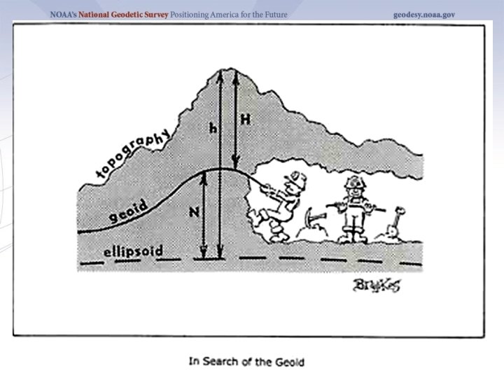
 H rence")


 NAD 83(PA 11) NAD 83(MA 11) The New: The")


 – Users with geodetic quality")

 Gravity and Heights are")


- Slides: 41
New Datums Are Coming in 2022 New York Geospatial Advisory Council March 27, 2018 Dan Martin Northeast Regional Geodetic Advisor ME, NH, VT, MA, CT, RI, NY, NJ Dan. martin@noaa. gov 240 -676 -4762
Session description and objectives • In 2022, the National Geodetic Survey will be replacing the U. S. horizontal and vertical datums (NAD 83 and NAVD 88). We will discuss the history of these datums, their relationship to other reference frames, the reasons for the change, and how it affects positioning professionals and their access to these datums. • Objective…gain a fundamental understanding of: – – How and why our datums/reference frames have changed over time The need to further modernize the US reference frames How NGS will define new reference frames How users will access the new reference frames
U. S. Department of Commerce National Oceanic & Atmospheric Administration National Geodetic Survey Mission: To define, maintain & provide access to the National Spatial Reference System (NSRS) to meet our Nation’s economic, social & environmental needs National Spatial Reference System • Latitude • Longitude • Height • Scale • Gravity • Orientation & their time variations
GEODETIC DATUMS HORIZONTAL 2 D (Latitude and Longitude) (e. g. NAD 27, NAD 83 (1986)) VERTICAL 1 D (Orthometric Height) (e. g. NGVD 29, NAVD 88, Local Tidal) GEOMETRIC 3 D (Latitude, Longitude and Ellipsoid Height) Fixed and Stable - Coordinates seldom change (e. g. NAD 83 (1996), NAD 83 (2007), NAD 83 (CORS 96) NAD 83 (2011)) also 4 D (Latitude, Longitude, Ellipsoid Height, Velocities) Coordinates change with time (e. g. ITRF 00, ITRF 08)
What is a Datum? • • • "A set of constants specifying the coordinate system used for geodetic control, i. e. , for calculating the coordinates of points on the Earth. " "The datum, as defined above, together with the coordinate system and the set of all points and lines whose coordinates, lengths, and directions have been determined by measurement or calculation. " NGS has used the first definition for NAD 83
A (very) brief history of NAD 83 • Original realization completed in 1986 – Consisted (almost) entirely of classical (optical) observations • “High Precision Geodetic Network” (HPGN) and “High Accuracy Reference Network” (HARN) realizations – Most done in 1990 s, essentially state-bystate – Based on GNSS but classical stations included in adjustments • National Re-Adjustment of 2007 – NAD 83(CORS 96) and (NSRS 2007) – Simultaneous nationwide adjustment (GNSS only) • New realization: NAD 83(2011) epoch 2010. 00
Why change datums/realizations • NAD 27 based on old observations and old system • NAD 83(86) based on old observations and new system • NAD 83(92, 96) based on new and old observations and same system (HARN/FBN) • NAD 83(NSRS 2007) based on new observations and same system. Removed regional distortions and made consistent with CORS • NAD 83(2011) based on new observations and same system. Kept consistent with CORS
National Spatial Reference System (NSRS) Improvements over time NETWORK TIME SPAN NETWORK ACCURACY LOCAL ACCURACY SHIFT NAD 27 1927 -1986 10 meters (1: 100, 000) 10 -200 m NAD 83(86) 1986 -1990 1 meter (1: 100, 000) 0. 3 -1. 0 m NAD 83(199 x)* “HARN”, “FBN” 1990 -2007 0. 1 meter (1: 1 million) (1: 10 million) 0. 05 m NAD 83(NSRS 2007) 2007 -2011 0. 01 meter 0. 03 m NAD 83(2011) 0. 01 meter 0. 01 m 2011 -
Horizontal Datums/Coordinates…What do we (you) use in your state? • WGS 84 • NAD 27 – Which one? ? ? • NAD 83 (Lat-Lon) SPC • WGS 84 (1987) – Which one? ? ? • WGS 84 (G 730) • NAD 83 (1986) • WGS 84 (G 873) • NAD 83 (1992) • WGS 84 (G 1150) • NAD 83 (1996) • WGS 84 (G 1674) • NAD 83 CORS 96(2002) • WGS 84 (G 1762) • NAD 83 (NSRS 2007) • NAD 83 (2011) epoch 2010. 00 • ITRFxx (epoch xxxx) • IGSxx (epoch xxxx)
ITRF 2008 For the geodesy, geophysics and surveying communities, the best International Terrestrial Reference Frame is the “gold standard. ” The global community adopted an updated expression for the reference frame, the ITRF 2008. 10
Simplified Concept of NAD 83 vs. ITRF 08 h 83 eters 2. 2 m NAD 83 Origin h 08 Earth’s Surface ITRF 08 Origin Identically shaped ellipsoids (GRS-80) a = 6, 378, 137. 000 meters (semi-major axis) 1/f = 298. 25722210088 (flattening)
History of vertical datums in the USA • NGVD 29 – National Geodetic Vertical Datum of 1929 – Original name: “Sea Level Datum of 1929” – “Zero height” held fixed at 26 tide gauges • Not all on the same tidal datum epoch (~ 19 yrs) – Did not account for Local Mean Sea Level variations from the geoid • Thus, not truly a “geoid based” datum
The National Geodetic Vertical Datum of 1929 is referenced to 26 tide gauges in the US and Canada
Current Vertical Datum in the USA • NAVD 88: North American Vertical Datum of 1988 • Definition: The surface of equal gravity potential to which orthometric heights shall refer in North America*, and which is 6. 271 meters (along the plumb line) below the geodetic mark at “Father Point/Rimouski” (NGSIDB PID TY 5255). • Realization: Over 500, 000 geodetic marks across North America with published Helmert orthometric heights, most of which were originally computed from a minimally constrained adjustment of leveling and gravity data, holding the geopotential value at “Father Point/Rimouski” fixed. Father Point Lighthouse, Quebec *Not adopted in Canada
History of vertical datums in the USA • NAVD 88 (continued) – Use of one fixed height removed local sea level variation problem of NGVD 29 – Use of one fixed height did open the possibility of unconstrained cross-continent error build up – But the H=0 surface of NAVD 88 was supposed to be parallel to the geoid…(close again)
3
Which Geoid for Which NAD 83? • NAD 83(2011) • Geoid 12 A/12 B • NAD 83(2007) • Geoid 09 • Geoid 06 (AK only) • NAD 83(1996) & CORS 96 • Geoid 03 • Geoid 99 • Geoid 96
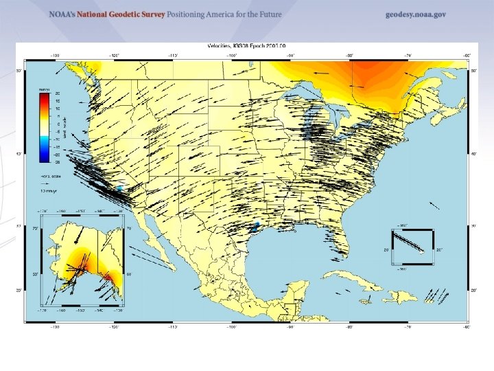
Problems with NAD 83 and NAVD 88 § NAD 83 is not as geocentric as it could be (approx. 2 m) § Positioning Professionals don’t see this - Yet § NAD 83 is not well defined with positional velocities § NAVD 88 is realized by passive control (bench marks) most of which have not been re-leveled in at least 40 years. § NAVD 88 does not account for local vertical velocities (subsidence and uplift) § § Post glacial isostatic readjustment (uplift) Subsurface fluid withdrawal (subsidence) Sediment loading (subsidence) Sea level rise
GRACE – Gravity Recovery and Climate Experiment
Why isn’t NAVD 88 good enough anymore? Earth’s Surface H (NAVD 88) H rence e f e r 8 8 D NAV The Geoid Errors in NAVD 88 : ~50 cm average, 100 cm CONUS tilt, 1 -2 meters average in Alaska level
Why isn’t NAVD 88 good enough anymore? • Approximate level of geoid mismatch known to exist in the NAVD 88 zero surface:
Height-Mod means More Marks?
Height Modernization -faster -cheaper Differential Leveling GNSS + …
The National Geodetic Survey 10 year plan Mission, Vision and Strategy 2008 – 2018, 2013 -2023 http: //www. ngs. noaa. gov/INFO/NGS 10 yearplan. pdf • Official NGS policy as of Jan 9, 2008 – Modernized agency – Attention to accuracy – Attention to time-changes – Improved products and services – Integration with other fed missions • 2022 Targets: – NAD 83 and NAVD 88 re-defined – Cm-accuracy access to all coordinates – Customer-focused agency – Global scientific leadership
Scientific Decisions • Blueprint for 2022, Part 1: Geometric üFour plate-fixed Terrestrial Reference Frames üAnd what “plate fixed” means üMathematical equation between IGS and TRFs üPlate Rotation Model for each plate üCoordinates at survey epoch üIntra-frame velocity model üTo compare coordinates surveyed at different epochs April 24, 2017 Geospatial Summit, Silver Spring, MD
Names The Old: NAD 83(2011) NAD 83(PA 11) NAD 83(MA 11) The New: The North American Terrestrial Reference Frame of 2022 (NATRF 2022) The Caribbean Terrestrial Reference Frame of 2022 (CTRF 2022) The Pacific Terrestrial Reference Frame of 2022 (PTRF 2022) The Mariana Terrestrial Reference Frame of 2022 (MTRF 2022) April 24, 2017 Geospatial Summit, Silver Spring, MD
Future Geometric Reference Frame • CORS-based, via GNSS • coordinates & velocities in ITRF and official US datum • Identical to the latest IGS reference frame (as available in 2022) at an epoch to be determined • replace NAD 83 with new geometric reference frame – by 2022 • passive control tied to new datum; not a component of new datum • address user needs of datum coordinate constancy vs. accuracy • lat / long / ellipsoid height of defining points accurate to 1 mm, anytime • CORS coordinates computed / published daily; track changes • support development of real-time networks
Scientific Decisions!! • Blueprint for 2022, Part 2: Geopotential üGlobal 3 -D Geopotential Model (GGM) üWill contain all GRAV-D data üAble to yield any physical value on/above surface üSpecial high-resolution geoid, Do. V and surface gravity products consistent with GGM üNot global: NA/Pacific, American Samoa, Guam/CNMI üTime-Dependencies üGeoid monitoring service ü Impacts of deglaciation, sea level rise, earthquakes, etc April 24, 2017 Geospatial Summit, Silver Spring, MD
Names Orthometric Heights Normal Orthometric Heights Dynamic Heights Gravity Geoid Undulations Deflections of the Vertical The Old: NAVD 88 PRVD 02 The New: VIVD 09 The North American-Pacific Geopotential ASVD 02 Datum of 2022 (NAPGD 2022) NMVD 03 GUVD 04 - Will include GEOID 2022 IGLD 85 IGSN 71 GEOID 12 B DEFLEC 12 B April 24, 2017 Geospatial Summit, Silver Spring, MD
Future Geopotential Reference Frame • replace NAVD 88 with new geopotential reference frame – by 2022 • gravimetric geoid-based, in combination with GNSS • monitor time-varying nature of gravity field • develop transformation tools to relate to NAVD 88 • build most accurate ever continental gravimetric geoid model (GRAV-D) • determine gravity with accuracy of 10 micro. Gals, anytime • support both orthometric and dynamic heights • Height Modernization is fully supported
Why replace NAVD 88 and NAD 83? • ACCESS! – easier to find the sky than a 60 -year-old bench mark – GNSS equipment is cheap and fast • ACCURACY! – easier to trust the sky than a 60 -year old bench mark – immune to passive mark instability • GLOBAL STANDARDS! – systematic errors of many meters across the US – aligns with GPS, international efforts – aligns with Canada, Mexico April 24, 2017 Geospatial Summit 32
Accessing the New Datums • Primary access (NGS mission) – Users with geodetic quality GNSS receivers will continue to use OPUS suite of tools – Ellipsoid heights computed, and then a gravimetric geoid removed to provide orthometric heights in the new datum – No passive marks needed – But, could be used to position a passive mark • Secondary access (Use at own risk) – Passive marks that have been tied to the new vertical datum – NGS will provide a “data sharing” service for these points, but their accuracy (due to either the quality of the survey or the age of the data) will not be a responsibility of NGS Continuously Operating Reference Station
Accessing the New Datums • NAD 83 conversion to new datum – A transformation will be provided • NAVD 88 conversion to new datum – A transformation will be provided (VERTCON) • Only where recent GNSS ellipsoid heights exist to provide modern heights in the new datum
Gravity for the Redefinition of the American Vertical Datum (GRAV-D) Gravity and Heights are inseparably connected • Replace the Vertical Datum of the USA by 2022 (at today’s funding) with a gravimetric geoid accurate to 1 cm • Orthometric heights accessed via GNSS accurate to 2 cm • Three thrusts of project: – Airborne gravity survey of entire country and its holdings – Long-term monitoring of geoid change – Partnership surveys • Working to launch a collaborative effort with the USGS for simultaneous magnetic measurement
What is GRAV-D? • GRAV-D will mean: – As the H=0 surface, the geoid will be tracked over time to keep the datum up to date – The reliance on passive marks will dwindle to: • Secondary access to the datum • Minimal NGS involvement – Maintenance/checking in the hands of users • Use at your own risk
Predicted Positional Changes in 2022 Vicinity of New Britain, CT (Computed for station W 91, pid LX 3162) HORIZONTAL = 1. 20 m (3. 9 ft) ELLIPSOID HEIGHT = - 1. 23 m (- 4. 0 ft) Predicted with HTDP ORTHOMETRIC HEIGHT = - 0. 32 m (- 1. 1 ft) Predicted with HTDP and x. GEOID 16 B HTDP “Coping with Tectonic Motion” R. Snay & C. Pearson American Surveyor Magazine, December 2010 www. Ameriserv. com
Predicted Positional Changes in 2022 Vicinity of Albany, NY. (Computed for station NEW SCOT, pid AA 7931) HORIZONTAL = 1. 21 m (4. 0 ft) ELLIPSOID HEIGHT = - 1. 19 m (- 3. 9 ft) Predicted with HTDP ORTHOMETRIC HEIGHT = - 0. 40 m (- 1. 3 ft) Predicted with HTDP and x. GEOID 17 B HTDP “Coping with Tectonic Motion” R. Snay & C. Pearson American Surveyor Magazine, December 2010 www. Ameriserv. com
metadata to the rescue • your positional metadata should include: – datum – epoch – source • these will facilitate transforming from current to new datum • maintaining your original survey data will provide more accurate results
Questions?