
NCAR Overview Cathy Kessinger Tenny Lindholm Dan Megenhardt
- Slides: 21
NCAR Overview Cathy Kessinger, Tenny Lindholm, Dan Megenhardt, Jason Craig 18 September 2019 Email: kessinge@ucar. edu
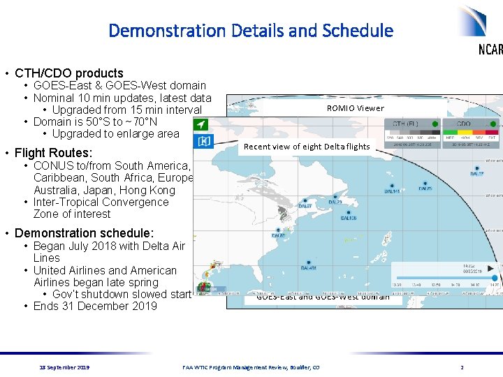
Demonstration Details and Schedule • CTH/CDO products • GOES-East & GOES-West domain • Nominal 10 min updates, latest data • Upgraded from 15 min interval • Domain is 50°S to ~70°N • Upgraded to enlarge area ROMIO Viewer Recent view of eight Delta flights • Flight Routes: • CONUS to/from South America, Caribbean, South Africa, Europe, Australia, Japan, Hong Kong • Inter-Tropical Convergence Zone of interest • Demonstration schedule: • Began July 2018 with Delta Air Lines • United Airlines and American Airlines began late spring • Gov’t shutdown slowed start • Ends 31 December 2019 18 September 2019 Enlarged GOES-East and GOES-West domain ROMIO Viewer showing previous GOES-East and GOES-West domain FAA WTIC Program Management Review, Boulder, CO 2
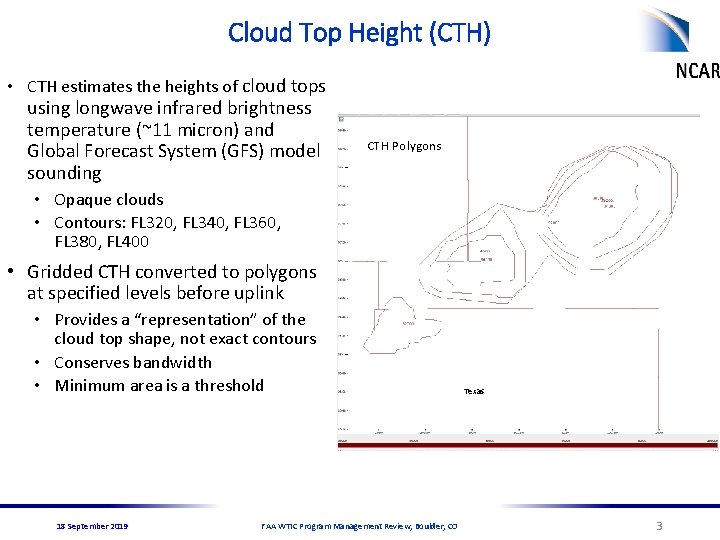
Cloud Top Height (CTH) • CTH estimates the heights of cloud tops using longwave infrared brightness temperature (~11 micron) and Global Forecast System (GFS) model sounding Infrared CTH Polygons Cloud Top. Temperature Height (CTH) Product • Opaque clouds • Contours: FL 320, FL 340, FL 360, FL 380, FL 400 Cold Temperatures • Gridded CTH converted to polygons at specified levels before uplink • Provides a “representation” of the cloud top shape, not exact contours • Conserves bandwidth • Minimum area is a threshold Texas FL 320 18 September 2019 FAA WTIC Program Management Review, Boulder, CO FL 340 FL 360 FL 380 FL 400 3
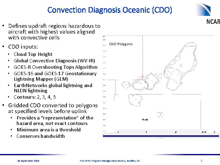
Convection Diagnosis Oceanic (CDO) • Defines updraft regions hazardous to aircraft with highest values aligned with convective cells • CDO inputs: Convective Infrared CDO Polygons Temperature Diagnosis Oceanic (CDO) Cloud Top Height Global Convective Diagnosis (WV-IR) GOES-R Overshooting Tops Algorithm GOES-16 and GOES-17 Geostationary Lightning Mapper (GLM) • Earth. Networks global lightning and NLDN lightning • Contours: 2, 3, 4, 5 • • Cold Temperatures • Gridded CDO converted to polygons at specified levels before uplink • Provides a “representation” of the hazard area, not exact contours • Minimum area is a threshold • Conserves bandwidth 18 September 2019 Texas 2 FAA WTIC Program Management Review, Boulder, CO 3 4 5 -6 4
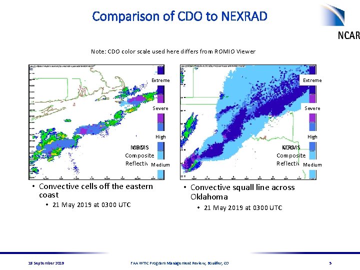
Comparison of CDO to NEXRAD Note: CDO color scale used here differs from ROMIO Viewer Extreme Severe High CDO MRMS Composite Reflectivity Medium • Convective cells off the eastern coast • 21 May 2019 at 0300 UTC 18 September 2019 CDO MRMS Composite Reflectivity Medium • Convective squall line across Oklahoma • 21 May 2019 at 0300 UTC FAA WTIC Program Management Review, Boulder, CO 5
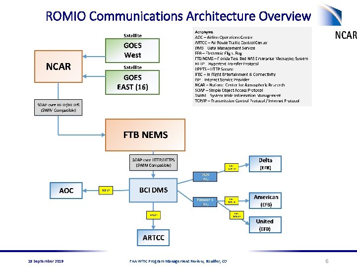
ROMIO Communications Architecture Overview 18 September 2019 FAA WTIC Program Management Review, Boulder, CO 6
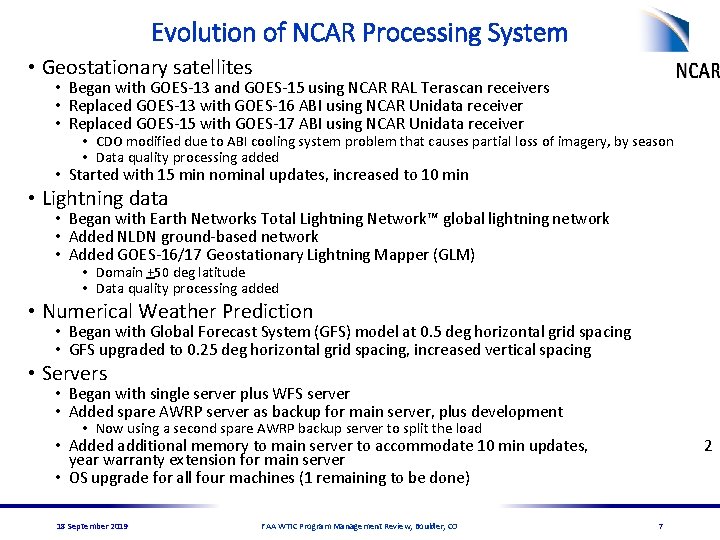
Evolution of NCAR Processing System • Geostationary satellites • Began with GOES-13 and GOES-15 using NCAR RAL Terascan receivers • Replaced GOES-13 with GOES-16 ABI using NCAR Unidata receiver • Replaced GOES-15 with GOES-17 ABI using NCAR Unidata receiver • CDO modified due to ABI cooling system problem that causes partial loss of imagery, by season • Data quality processing added • Started with 15 min nominal updates, increased to 10 min • Lightning data • Began with Earth Networks Total Lightning Network™ global lightning network • Added NLDN ground-based network • Added GOES-16/17 Geostationary Lightning Mapper (GLM) • Domain +50 deg latitude • Data quality processing added • Numerical Weather Prediction • Began with Global Forecast System (GFS) model at 0. 5 deg horizontal grid spacing • GFS upgraded to 0. 25 deg horizontal grid spacing, increased vertical spacing • Servers • Began with single server plus WFS server • Added spare AWRP server as backup for main server, plus development • Now using a second spare AWRP backup server to split the load • Added additional memory to main server to accommodate 10 min updates, year warranty extension for main server • OS upgrade for all four machines (1 remaining to be done) 18 September 2019 FAA WTIC Program Management Review, Boulder, CO 2 7
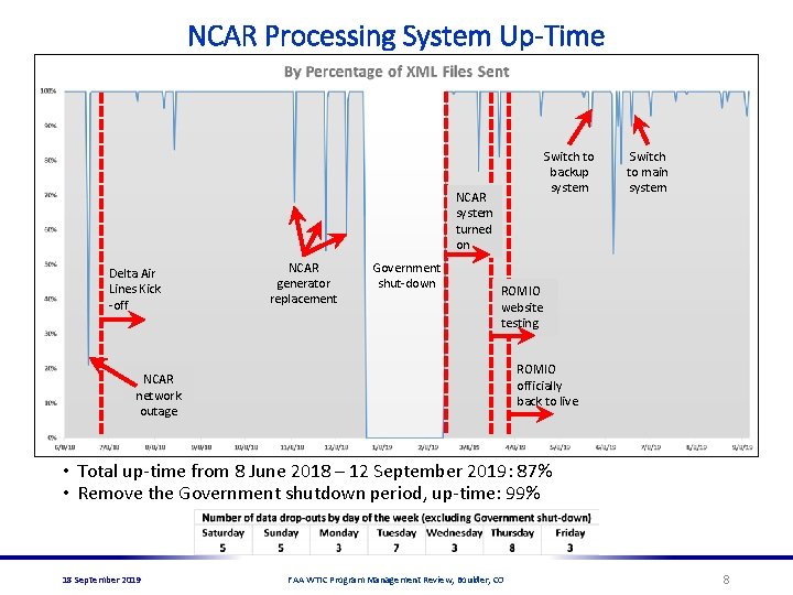
NCAR Processing System Up-Time Switch to backup system NCAR system turned on Delta Air Lines Kick -off NCAR generator replacement Government shut-down Switch to main system ROMIO website testing ROMIO officially back to live NCAR network outage • Total up-time from 8 June 2018 – 12 September 2019: 87% • Remove the Government shutdown period, up-time: 99% 18 September 2019 FAA WTIC Program Management Review, Boulder, CO 8
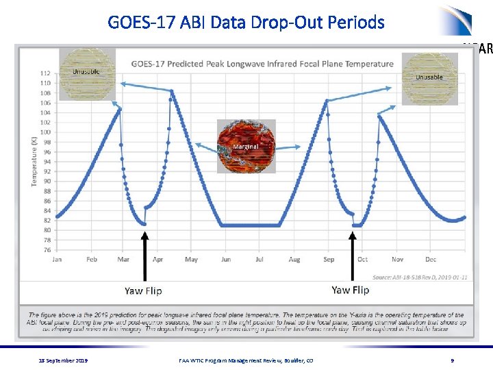
GOES-17 ABI Data Drop-Out Periods 18 September 2019 FAA WTIC Program Management Review, Boulder, CO 9
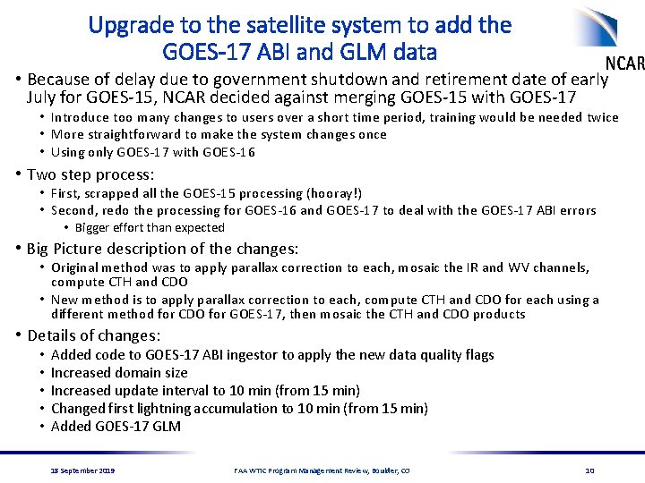
Upgrade to the satellite system to add the GOES-17 ABI and GLM data • Because of delay due to government shutdown and retirement date of early July for GOES-15, NCAR decided against merging GOES-15 with GOES-17 • Introduce too many changes to users over a short time period, training would be needed twice • More straightforward to make the system changes once • Using only GOES-17 with GOES-16 • Two step process: • First, scrapped all the GOES-15 processing (hooray!) • Second, redo the processing for GOES-16 and GOES-17 to deal with the GOES-17 ABI errors • Bigger effort than expected • Big Picture description of the changes: • Original method was to apply parallax correction to each, mosaic the IR and WV channels, compute CTH and CDO • New method is to apply parallax correction to each, compute CTH and CDO for each using a different method for CDO for GOES-17, then mosaic the CTH and CDO products • Details of changes: • • • Added code to GOES-17 ABI ingestor to apply the new data quality flags Increased domain size Increased update interval to 10 min (from 15 min) Changed first lightning accumulation to 10 min (from 15 min) Added GOES-17 GLM 18 September 2019 FAA WTIC Program Management Review, Boulder, CO 10
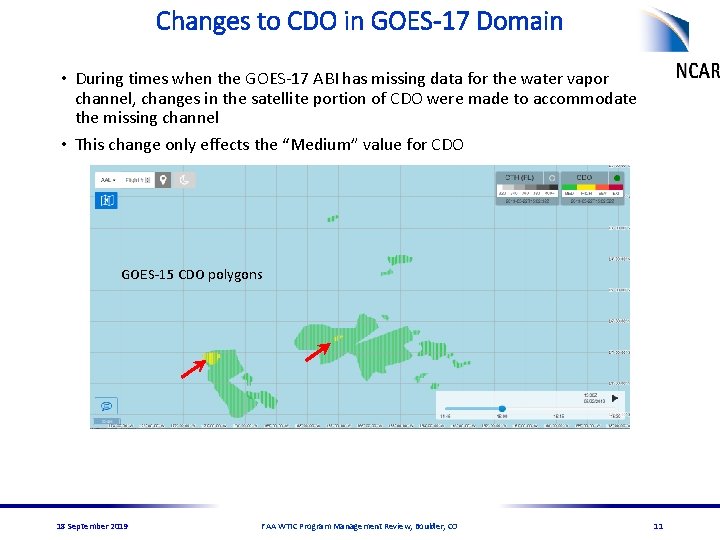
Changes to CDO in GOES-17 Domain • During times when the GOES-17 ABI has missing data for the water vapor channel, changes in the satellite portion of CDO were made to accommodate the missing channel • This change only effects the “Medium” value for CDO GOES-15 CDO polygons 22 May 2019 18 September 2019 FAA WTIC Program Management Review, Boulder, CO 11
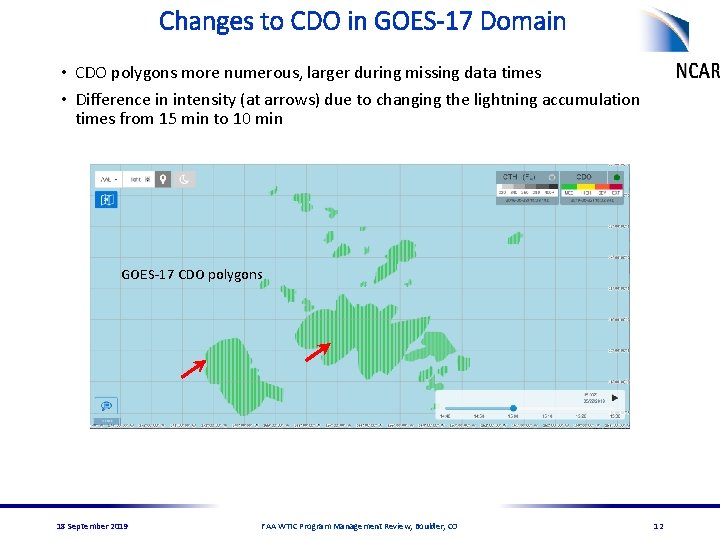
Changes to CDO in GOES-17 Domain • CDO polygons more numerous, larger during missing data times • Difference in intensity (at arrows) due to changing the lightning accumulation times from 15 min to 10 min GOES-17 CDO polygons 22 May 2019 18 September 2019 FAA WTIC Program Management Review, Boulder, CO 12
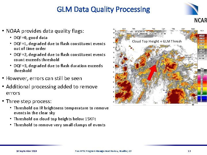
GLM Data Quality Processing • NOAA provides data quality flags: • DQF=0, good data • DQF=1, degraded due to flash constituent events out of time order • DQF=2, degraded due to flash constituent events count exceeds threshold • DQF=3, degraded due to flash duration exceeds threshold Cloud Top Height + GLM Thresh • However, errors can still be seen • Additional processing added to remove errors • Three step process: • Threshold on IR brightness temperature to remove events in the clear sky • Threshold on cloud top heights below 15 KFt • Threshold to remove very small clumps of events 18 September 2019 FAA WTIC Program Management Review, Boulder, CO 13
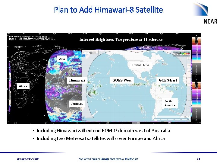
Plan to Add Himawari-8 Satellite Infrared Brightness Temperature at 11 microns Asia United States Himawari GOES-West GOES-East Africa Australia South America • Including Himawari will extend ROMIO domain west of Australia • Including two Meteosat satellites will cover Europe and Africa 18 September 2019 FAA WTIC Program Management Review, Boulder, CO 14
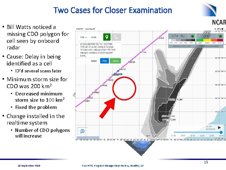
Two Cases for Closer Examination • Bill Watts noticed a missing CDO polygon for cell seen by onboard radar • Cause: Delay in being identified as a cell • ID’d several scans later • Minimum storm size for CDO was 200 km 2 • Decreased minimum storm size to 100 km 2 • Fixed the problem • Change installed in the realtime system • Number of CDO polygons will increase 18 September 2019 FAA WTIC Program Management Review, Boulder, CO 15
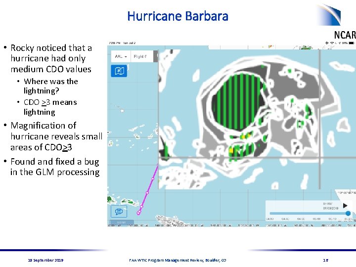
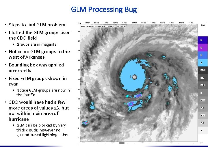
Hurricane Barbara • Rocky noticed that a hurricane had only medium CDO values • Where was the lightning? • CDO >3 means lightning • Magnification of hurricane reveals small areas of CDO>3 • Found and fixed a bug in the GLM processing 18 September 2019 FAA WTIC Program Management Review, Boulder, CO 16
GLM Processing Bug • Steps to find GLM problem • Plotted the GLM groups over the CDO field • Groups are in magenta • Notice no GLM groups to the west of Arkansas • Bounding box was applied incorrectly • Fixed GLM groups shown in cyan • Notice GLM groups are now in the Pacific • CDO would have had a few more areas of values >3, but not within main area of hurricane • GLM can be blocked by very thick clouds; however no ground-based lightning either
Collaboration with Virginia Tech • Send the month’s XML files of CDO, CTH and missing data polygons to them • When the CTH contours were changed, did a reanalysis of several month’s of previous data and sent the new XML files to VT • Contours changed from FL 300, FL 350, FL 400, FL 450 and FL 500 to FL 320, FL 340, FL 360, FL 380 and FL 400 18 September 2019 FAA WTIC Program Management Review, Boulder, CO 18
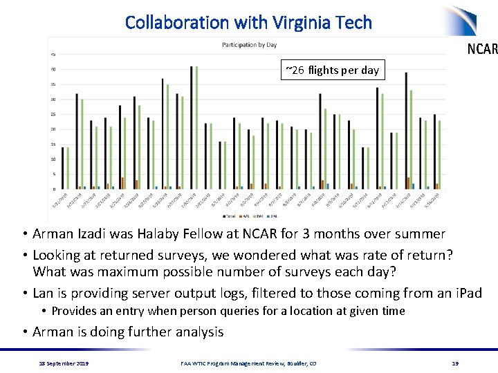
Collaboration with Virginia Tech ~26 flights per day • Arman Izadi was Halaby Fellow at NCAR for 3 months over summer • Looking at returned surveys, we wondered what was rate of return? What was maximum possible number of surveys each day? • Lan is providing server output logs, filtered to those coming from an i. Pad • Provides an entry when person queries for a location at given time • Arman is doing further analysis 18 September 2019 FAA WTIC Program Management Review, Boulder, CO 19
Thanks! 18 September 2019 FAA WTIC Program Management Review, Boulder, CO 20
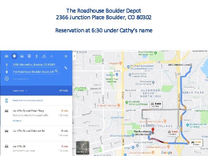
The Roadhouse Boulder Depot 2366 Junction Place Boulder, CO 80302 Reservation at 6: 30 under Cathy’s name