NATURAL HAZARDS MISSION AREA SAFRR Project Science Application
 – How")


 earthquake scenario (2008) ARk.")


- Slides: 12
NATURAL HAZARDS MISSION AREA SAFRR Project: Science Application for Risk Reduction (SAFRR) – How Might SAFRR Help You? Ken Hudnut, Science Advisor for Risk Reduction (SAFRR) Dale Cox, Project Manager (SAFRR) 11 Natural Hazards: Earthquake • Volcanic Eruption • Landslide • Flood • Geomagnetic Storm • Wildfire • Tsunami • Coastal Erosion
The SAFRR Project SAFRR: Science Application for Risk Reduction The mission of SAFRR is to innovate the application of hazard science for the safety, security, and economic well-being of the nation. 11 Natural Hazards: Earthquake • Volcanic Eruption • Landslide • Flood • Geomagnetic Storm • Wildfire • Tsunami • Coastal Erosion
SAFRR Helps Reduce Risk Geologic hazards produce“low probability, high consequence” events: • They don’t often happen… Ø But they can happen at any time • We often neglect them to deal with more everyday needs… Ø But if one of these happens, we’ll wish we’d prepared! SAFRR: • Identifies pressing (often unrecognized) aspects of risk reduction for geologic hazards • Brings the best available hazard science to bear on the problem • Organizes a collaboration of cross-disciplinary experts from academia, government, NGOs, and private sector • Works throughout with potential users as collaborators
How It Works SAFRR identifies the location, users/audience, potential hazards Example Location – a city, state, region, or type of facility Example Audience – local, regional, state, federal government; emergency managers; lifeline operators, business sector (continuity of operations / contingency planners / supply chain vulnerability analysts) Users (members of the audience) help: Identify what’s at risk Prioritize their needs from SAFRR Select/invite local participants SAFRR and users build coalition to get buy-in, develop, broadcast, and use the project results
Why We’re Here Today Find out your hazard/risk needs Identify whether SAFRR’s approach can help If it can, decide our steps forward Natural hazards represent an important part of the threats & hazards matrix. We want to help, and if you’d to build on a foundation of scientific realism for your future exercises, we can support that need by connecting you to published info & subject matter experts who are eager to assist!
The SAFRR Scenarios Shake. Out: San Andreas fault (southern California) earthquake scenario (2008) ARk. Storm: winter storm scenario impacting U. S. West Coast (2010) Tsunami Scenario: tsunami generated by an Alaskan earthquake and impacting the U. S. West Coast (2013) Hay. Wired: Hayward fault (northern California) earthquake scenario (in progress) Southwest Climate Extremes: drought, storms, long periods of heat, sea-level rise (in initiation stage)
Components of a SAFRR Scenario Outputs Outcomes Working Groups Source Secondary Hazards Physical Damages Exposed Vulnerabilities Scientific Reports & Tools Social/Economi c Impacts Products, Simulations, Communication tools (e. g. on web) Policy Considerations Emergency Response Exercises Relationships Research Application Mitigation Education Resilience Use of science in decisionmaking (through exercises!) for risk reduction
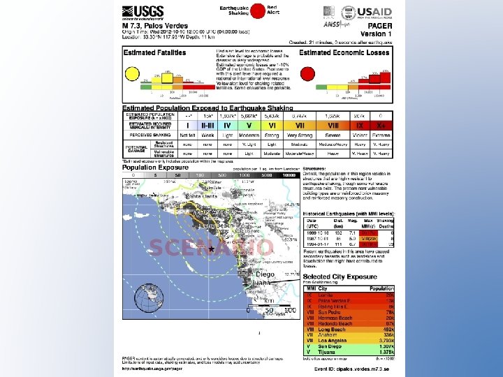
2016 Los Angeles Fleet Week Scenario: Magnitude 7. 3 Earthquake on the Palos Verdes Fault
Scenario: Magnitude 7. 3 Earthquake on the Palos Verdes Fault Consequences from HAZUS runs by CGS (2009) & SCEC (2013): • • • 5, 242 casualties (injuries and fatalities) if the earthquake occurs at 2 pm (when most people are expected to be at work or school) $10. 9 billion direct economic loss due to building damage Surface fault rupture of 6 to 9 feet of right-lateral (horizontal shift) offset that would contribute significantly to the overall damage – Severs communication link to FAA San Pedro Hill radar facility • • Significant disruption of lifeline infrastructure along the Palos Verdes fault on-land from San Pedro to Torrance along the break in hill slope from the flat ground (NE side) to the hill (SW side) of the Palos Verdes peninsula Fire Following Earthquake and Multiple Large Oil Spills (PMAO exercise? ) – Oil refineries damages – Liquid Bulk Facilities damages • Isolation of Peninsula and Port Complex – Bridge inspections required and probably damage (Vincent Thomas, Gerald Desmond, Bager Ave) – Landslides (Gaffey Street, Portuguese Bend) • Liquefaction
+ 3 DEP Supports USGS Science Coastal Hazards Insert Visual 11
Questions? Ken Hudnut, hudnut@usgs. gov Dale A. Cox, dacox@usgs. gov