NATS 101 Introduction to Weather and Climate Section




- Slides: 44

NATS 101 Introduction to Weather and Climate Section 5: T/R 2: 00 – 3: 15 pm Lecturer: TAs: ILC 120 Prof. Elizabeth A. Ritchie, ATMO Ms. Simona Olson

Important Information • Office Hours: Prof. Ritchie – T/W 11: 00 -11: 50 am or by appointment, PAS 570 Ph: 626 -7843 (except Aug 25 - Sep 14) Ms. Olson – T 3: 30 -5: 00 pm & W 3: 00 -4: 00 pm or by appointment, PAS 526 Ph: 621 -6843 • Required Text: Understanding Weather and Climate, 4 rd Ed. by E. Aguado and J. E. Burt

Attendance Policy Attendance is mandatory, and I reserve the right to tally it throughout the term. http: //catalog. arizona. edu/2006 -07/policies/classatten. htm Attendance does go into your grade and can make the difference between a higher or lower letter grade if you are borderline.

Student Behavior UA Code of Academic Integrity, Code of Conduct and Student Code of Conduct are enforced in this course. Every student is responsible for learning these codes and abiding by them. http: //w 3. arizona. edu/~studpubs/policies/ppmainpg. html Students can submit complaints online at http: //web. arizona. edu/~dos/uapolicies/

Grading: Homeworks • There will be eight homeworks throughout the semester, which are to be downloaded and printed off from the Course website by each student. Dates when they become available, and when they are due are listed on the website. Homeworks are due at the beginning of class on the dates shown. • The lowest score among the eight homeworks will be dropped from the course grade. *** THEREFORE, NO LATE HOMEWORKS WILL BE ACCEPTED ***

Grading: Weather Diagram You will each prepare a time series chart of sea-level pressure (SLP) and temperature (T) observations recorded from the Tucson NWS office for the month beginning September 17. In addition, you will take your own personal observations of the weather every day noting special conditions, e. g. , windy, rain, hot, cold, etc, and add these to the time series. You will prepare a half page text analysis of the observations discussing the relationship between the temperatures, sealevel pressures, and weather conditions of the day. Details of how you will accomplish this are provided on the course website. The neatly drawn, completed chart will be turned in with your second midterm exam for grading and credit. Note: you will need the weather diagram to answer questions on the midterm exam.

Grading: Midterm Exams • There will be three midterm exams at regular intervals through the semester. These will occur on September 18, October 23, and November 20. These dates are listed in the course outline provided on the website. • Students who arrive late on midterm days will be not allowed to take the exam after the first student turns in her/his exam. NO EXCEPTIONS • The lowest score among the three midterm exams will be excluded from the course grade. *** THEREFORE, NO MAKE-UP EXAMS ***

Grading: Final Examination Section 5 (2: 00 pm T/R): ILC 120 December 16, 2: 00 pm - 4: 00 pm No Exceptions per UA Policy • The final will be comprehensive, covering all material from the course. • I suggest you double-check the date and time of this exam.

Grading Algorithm • • • 25% 15% 25% 10% Homework (lowest score dropped) Weather Diagram Midterm Exams (best 2 of 3 scores) Final Exam Class Participation NO EXTRA CREDIT PROJECTS. NO EXCEPTIONS. SO PLAN ACCORDINGLY!

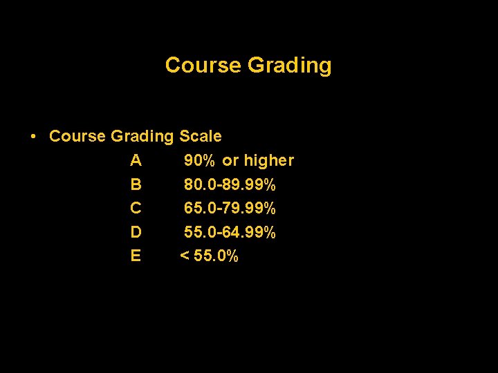
Course Grading • Course Grading Scale A 90% or higher B 80. 0 -89. 99% C 65. 0 -79. 99% D 55. 0 -64. 99% E < 55. 0%

Lecture Notes: for the next lecture will be made available in a printer-friendly pdf format the afternoon after the current lecture is over. Print them off and bring them to class. The lectures are almost exclusively power-pointbased and you will need the prints to make notes on

The Golden Rule Instructor and students all show: Mutual Respect! What exemplifies respectful behavior? No talking Turn off cell phones/pagers/ipods… Arrive on time Remain seated until dismissed

Literacy Requirements • Use scientific notation for writing numbers (especially rather large or small ones). For example: 1, 000. 0 should be written as 1. 0 x 106. 0. 00006 should be written as 6. 0 x 10 -5. • Specify units of physical quantities (e. g. meters for elevation, etc. ). Marks will be deducted if units are missing. • Always show all working. A correct number pulled out of a hat will NOT receive full credit! • Basic algebra will be needed for some problems in this class. If you have trouble understanding how to do these problems, seek help early!

Class Format: Lecture Days • 5 -10 minutes - Announcements, Map Discussion and Forecast • 2 -3 minutes - Review/Summary/Clean-up From Prior Lecture (Optional) • 60 -65 minutes - New Material, Demos, Discussion • 2 -3 minutes - Wrap-up and Summary

Announcements Course Homepage…is functional! http: //www. atmo. arizona. edu/ Click Course Links Click NATS 101 – Ritchie All information pertaining to this course is contained on the webpage. Review problem sets and solution sets will be provided through the webpage. You should immediately get a U of A account if you do not already have one so that you can access this website and take advantage of the U of A computing facilities. All email correspondence to myself or the TA should be via your. arizona. edu email otherwise it risks being automatically deleted as spam mail.

NATS 101 Weather Brief

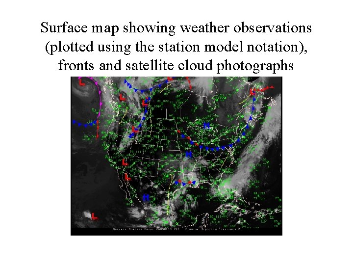
Surface map showing weather observations (plotted using the station model notation), fronts and satellite cloud photographs

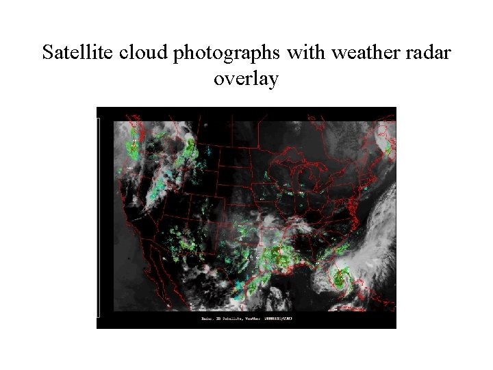
Satellite cloud photographs with weather radar overlay

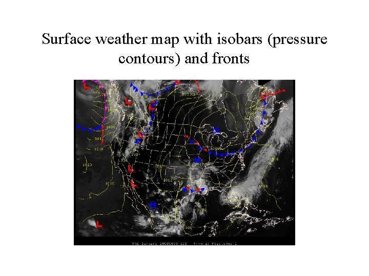
Surface weather map with isobars (pressure contours) and fronts

NATS 101 Lecture 1 Basic weather symbols and fronts

We describe weather in terms of: temperature humidity pressure wind clouds precipitation patterns visibility sunlight/UV weather the heat we feel, atthe air If. We we “feel” observe theseas weather elements an“weight” instanceofinthe time, we breathe. then we obtain a measure of the weather If we measure these weather elements over many years, then we obtain the “climate” of the region. Therefore: - climate represents an average of daily weather over a long period of time - Weather is the instantaneous condition of the atmosphere.

“Climate is what we expect” “Weather is what we get”

Pressure and Wind Atmospheric pressure impacts every aspect of weather although we do not easily recognize differences in pressure. - Air moves from high pressure to low pressure → wind - Air tends to rise in regions of low pressure and sink in regions of high pressure Pressure Units: mb, h. Pa, inches Hg, mm Hg Wind Units: m/s, mph, km/h, kts

Temperature - tends to change gradually in horizontal or vertical directions - also changes with time for the same weather system → diurnal cycle - the only place there are rapid changes in temperature is in the vicinity of fronts Units: - °C, °F, K

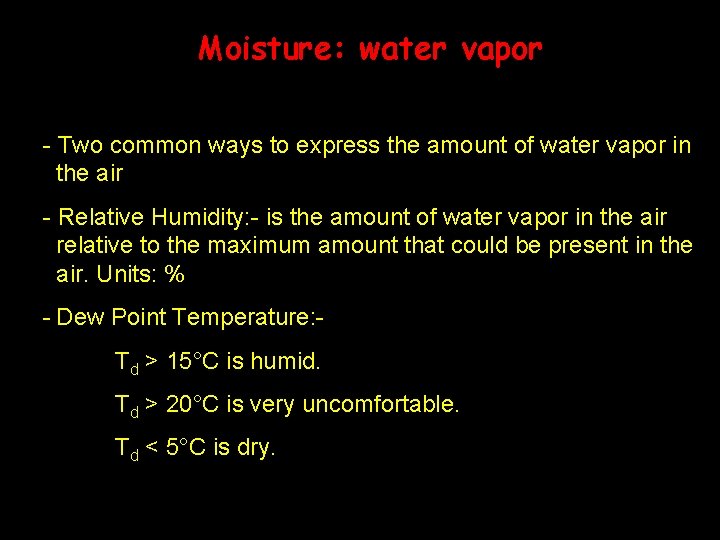
Moisture: water vapor - Two common ways to express the amount of water vapor in the air - Relative Humidity: - is the amount of water vapor in the air relative to the maximum amount that could be present in the air. Units: % - Dew Point Temperature: Td > 15°C is humid. Td > 20°C is very uncomfortable. Td < 5°C is dry.

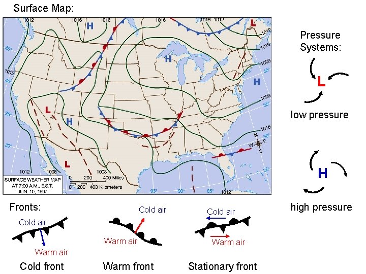
Surface Map: Pressure Systems: L low pressure H Fronts: Cold air Warm air Cold front Warm front Stationary front high pressure

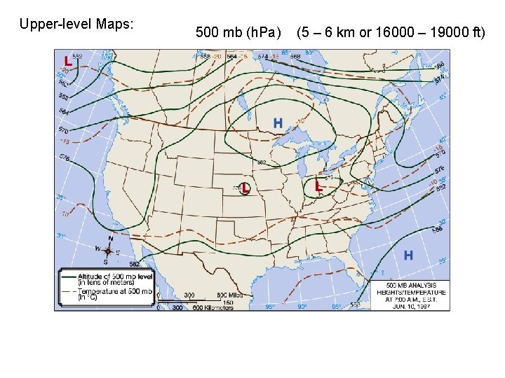
Upper-level Maps: 500 mb (h. Pa) (5 – 6 km or 16000 – 19000 ft)

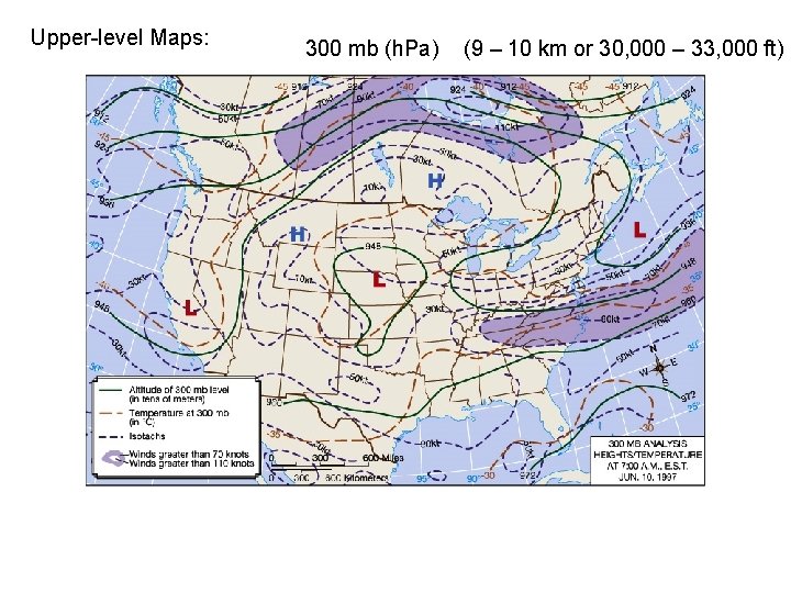
Upper-level Maps: 300 mb (h. Pa) (9 – 10 km or 30, 000 – 33, 000 ft)

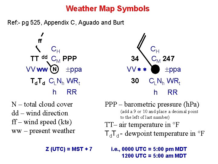
Weather Map Symbols Ref: - pg 525, Appendix C, Aguado and Burt ff CH TT dd CM PPP VV ww N ppa Td. Td CLNh WRt h RR N – total cloud cover dd – wind direction ff – wind speed (kts) ww – present weather Z (UTC) = MST + 7 CH 34 CM 247 VV ppa 30 CLNh WRt h RR PPP – barometric pressure (h. Pa) (add a 9 or 10 and place a decimal point to the left of last number) TT– air temperature in °F Td. Td - dewpoint temperature in °F i. e. , 0000 UTC = 5: 00 pm MDT 1200 UTC = 5: 00 am MDT

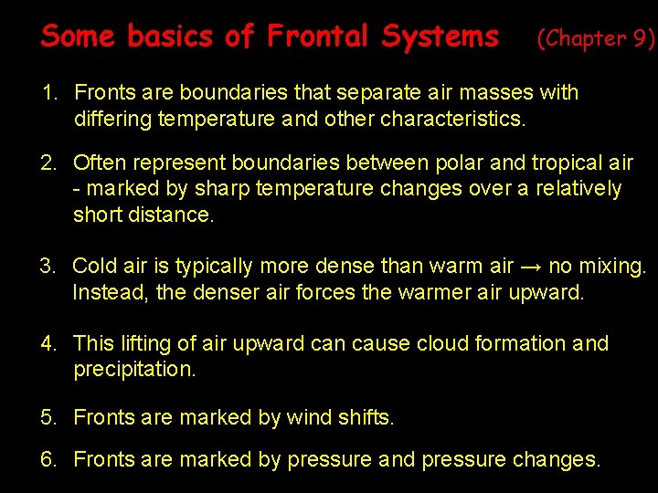
Some basics of Frontal Systems (Chapter 9) 1. Fronts are boundaries that separate air masses with differing temperature and other characteristics. 2. Often represent boundaries between polar and tropical air - marked by sharp temperature changes over a relatively short distance. 3. Cold air is typically more dense than warm air → no mixing. Instead, the denser air forces the warmer air upward. 4. This lifting of air upward can cause cloud formation and precipitation. 5. Fronts are marked by wind shifts. 6. Fronts are marked by pressure and pressure changes.

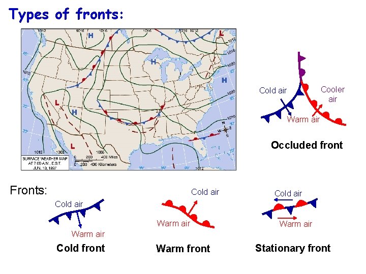
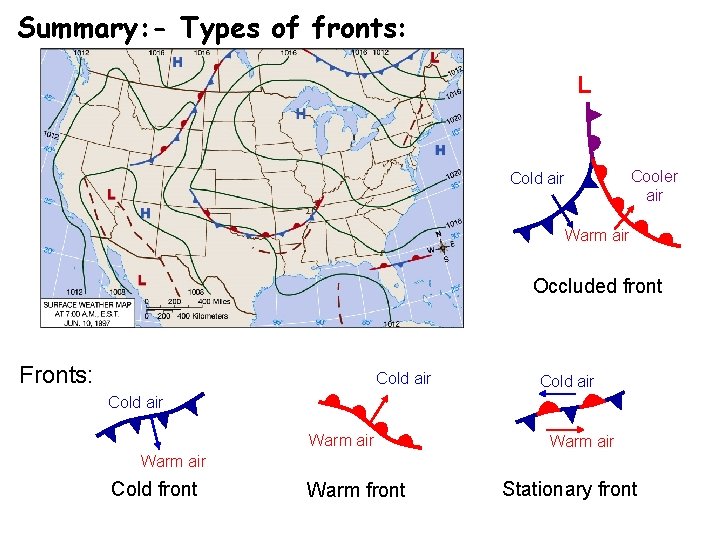
Types of fronts: Cold air Cooler air Warm air Occluded front Fronts: Cold air Warm air Cold front Warm front Stationary front

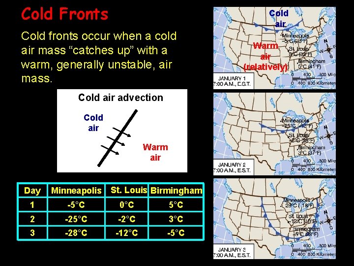
Cold Fronts Cold air Cold fronts occur when a cold air mass “catches up” with a warm, generally unstable, air mass. Cold air advection Cold air Warm air Day Minneapolis St. Louis Birmingham 1 -5°C 0°C 5°C 2 -25°C -2°C 3 -28°C -12°C -5°C Warm air (relatively)

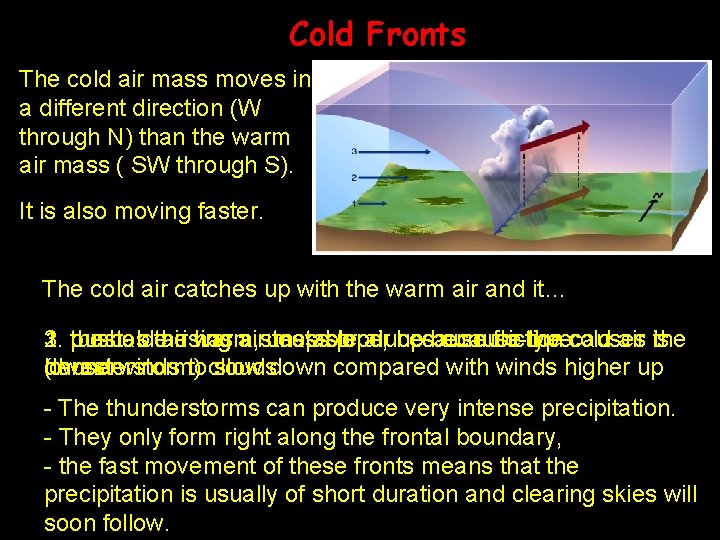
Cold Fronts The cold air mass moves in a different direction (W through N) than the warm air mass ( SW through S). It is also moving faster. The cold air catches up with the warm air and it… 3. the 1. 2. pushes unstable coldthe air rising has warm, air a steep unstable massslope, produces air because up because cumulo-type friction the cold causes air is the denser winds toclouds lowest (thunderstorm) slow down compared with winds higher up - The thunderstorms can produce very intense precipitation. - They only form right along the frontal boundary, - the fast movement of these fronts means that the precipitation is usually of short duration and clearing skies will soon follow.

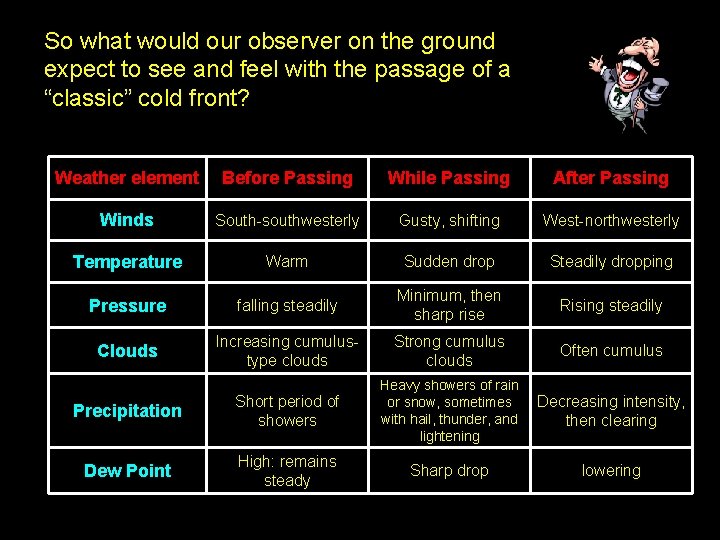
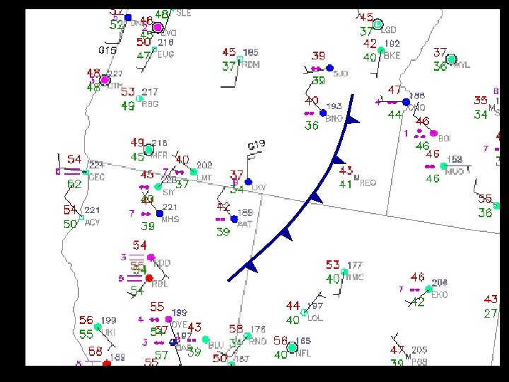
So what would our observer on the ground expect to see and feel with the passage of a “classic” cold front? Weather element Before Passing While Passing After Passing Winds South-southwesterly Gusty, shifting West-northwesterly Temperature Warm Sudden drop Steadily dropping Pressure falling steadily Minimum, then sharp rise Rising steadily Clouds Increasing cumulustype clouds Strong cumulus clouds Often cumulus Precipitation Short period of showers Heavy showers of rain or snow, sometimes with hail, thunder, and lightening Decreasing intensity, then clearing Dew Point High: remains steady Sharp drop lowering


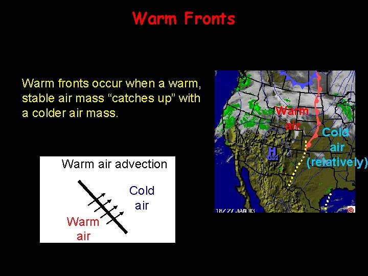
Warm Fronts Warm fronts occur when a warm, stable air mass “catches up” with a colder air mass. Warm air advection Cold air Warm air Cold air (relatively)

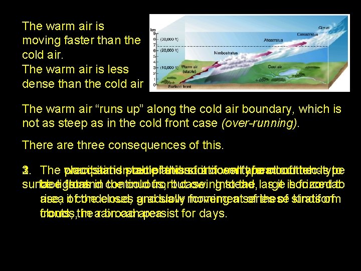
The warm air is moving faster than the cold air. The warm air is less dense than the cold air The warm air “runs up” along the cold air boundary, which is not as steep as in the cold front case (over-running). There are three consequences of this. 1. The clouds 3. 2. precipitation warm air and is stable precipitation out ofand thisso stratiform it doesn’t welltype ahead form cloud cumulo-type of the tends to surface be light clouds front. as and in continuous, the cold frontbut case. owing Instead, to the large as it is horizontal forced to area itofcondenses rise, the cloud, and gradually slow movement forming a series of these of stratiform kinds of fronts, the clouds, in arain broad canarea. persist for days.

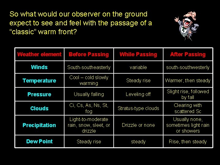
So what would our observer on the ground expect to see and feel with the passage of a “classic” warm front? Weather element Before Passing While Passing After Passing Winds South-southeasterly variable south-southwesterly Temperature Cool – cold slowly warming Steady rise Warmer, then steady Pressure Usually falling Leveling off Slight rise, followed by fall Clouds Ci, Cs, As, Ns, St, fog Stratus-type clouds Clearing with scattered Sc Precipitation Light-to-moderate rain, snow, sleet, or drizzle Drizzle or none Usually none, sometimes light rain or showers Dew Point Steady rise steady Rise, then steady

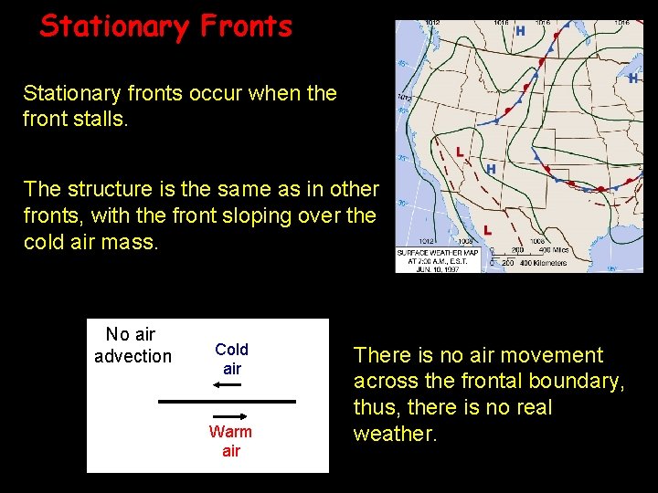
Stationary Fronts Stationary fronts occur when the front stalls. The structure is the same as in other fronts, with the front sloping over the cold air mass. No air advection Cold air Warm air There is no air movement across the frontal boundary, thus, there is no real weather.

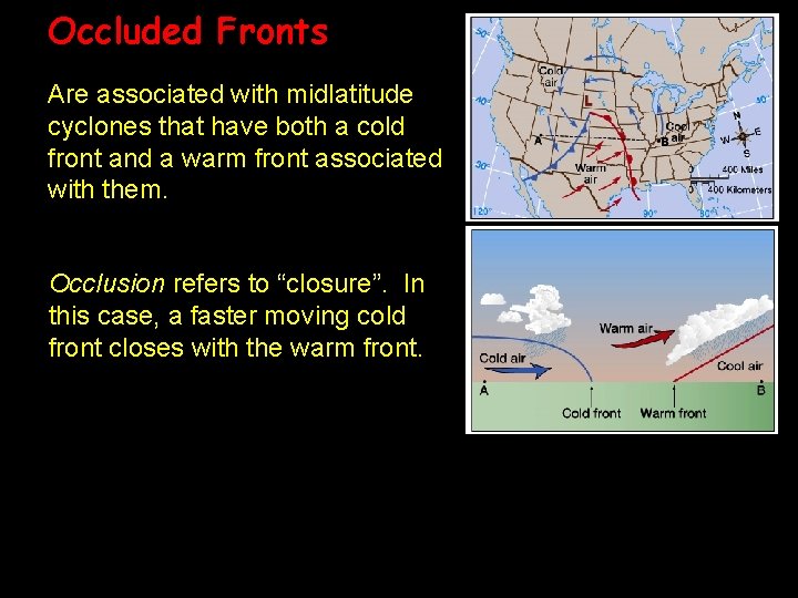
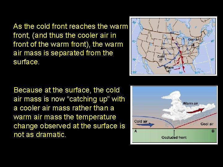
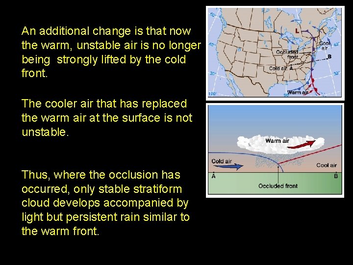
Occluded Fronts Are associated with midlatitude cyclones that have both a cold front and a warm front associated with them. Occlusion refers to “closure”. In this case, a faster moving cold front closes with the warm front.

As the cold front reaches the warm front, (and thus the cooler air in front of the warm front), the warm air mass is separated from the surface. Because at the surface, the cold air mass is now “catching up” with a cooler air mass rather than a warm air mass the temperature change observed at the surface is not as dramatic.

An additional change is that now the warm, unstable air is no longer being strongly lifted by the cold front. The cooler air that has replaced the warm air at the surface is not unstable. Thus, where the occlusion has occurred, only stable stratiform cloud develops accompanied by light but persistent rain similar to the warm front.

Summary: - Types of fronts: L Cold air Cooler air Warm air Occluded front Fronts: Cold air Warm air Cold front Warm front Stationary front

Reading Assignment • Aguado and Burt Pages 21 -26 Pages 525 -527 (Appendix C)