National status and activity report Romania Belgrad 03

National status and activity report Romania Belgrad, 03 -04 December, 2012

Agenda v. Romania Inland ENC v. Romania projects involved v. IRIS Europe 3 v. Newada Duo v. Geodetic Danube network; v. AFDJ – Waterway Database; v. SAFER Danube;

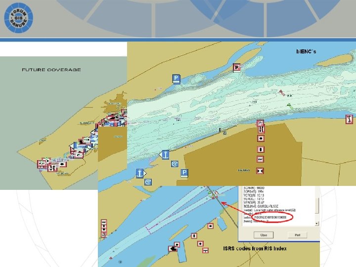
Romania – Inland ENCs

Inland ENC`s Coverage Danube Bala branch Borcea branch Macin branch Sfantu Gheorghe branch Danube – Black Sea Canal Total length 2012 2013 1075 rkm 10 rkm 92 rkm 1075 rkm 10 rkm 68 rkm 100 rkm 109 rkm 92 rkm 1177 rkm 1454 rkm

Accuracy of data inside Inland ENC`s Accuracy of data source and user-required accuracy < 1 m from geodetic/terrestric survey, taken from base map (1: 1000, 1: 2000) < 3 m from photogrammetry; digitized from aerophoto < 10 m digitized from topographic map (1: 10. 000, 1: 25. 000)

New Edition of Inland ENC`s • Second edition of Romanian Inland ENC`s with: – New coverage; – Preparation for full interoperability RIS Index; – Bathymetric layer b. IENC`s;

ORGANIZATIONAL ISSUES New webpage for Inland ENC`s; Efficient process for updating IENC`s; Collaboration with Romanian shipowners;

PROJECTS

IRIS Europe 3

IRIS Europe 3 v. Enhancement of RIS key technologies and systems, RIS Services and applications; v. Implementation of new harmonized RIS Services; v. Contribution to the maintenance and amendment of standards and technical specifications.

IRIS Europe 3 Partner: Romania Beneficiar: AFDJ Galati; Role in project: coordinator 1. 2. 3. 4. 5. Bathymetric ENC ; Transient water level models; Standardised IENC data exchange; Pilot implementation of Qo. IS for Inland ECDIS; Interoperability between RIS and maritime information services;

Work done; • First survey session for pilot stretch Bechet – Corabia, May 2013; • Activities for analysis of dynamics of morphology towards bathymetry information; • Second survey for pilot stretch Bechet – Corabia, July 2013; • Feasibility study on options for introducing bathymetric information within the IENCs

Survey – Corabia; - Bathymetry profiles - Current-meter profiles - Discharge and flow velocity measurements - Sediments measurements

Bathymetry – Romania; Current situation - possibilities of bathymetric data within Romanian Inland ENCs; • Current procedure for introducing bathymetric data within IENC – Phase 1 : Organizing the measurement session including checking and calibration of the measurement system – Phase 2 : On field measurements (using Hypack Survey and Hysweep)

Bathymetry – Romania; • Current tested procedure for introducing bathymetric data within IENC – Phase 3 : Data processing(Hypack Office, Single and Multi Beam Editor) – Phase 4 : Data integration within the IENCs as: • separate file • part of the main IENC cell

Bathymetry – Romania; Romanian IRIS II results Integration of bathymetric data within 60 km of Danube

Bathymetry – Romania; Option 1: Bathymetry as a separate file b. IENC • Encountered technical difficulties to correctly display simultaneously in ECDIS viewer Integrated display IENC + b. IENC xyz file Hypack ENC Editor Displayed b. IENC file Exported b. IENC file

Bathymetry – Romania; Option 2: Bathymetry integrated into the official IENC • • One IENC No technical difficulties to display in ECDIS viewer Displayed IENC xyz file Hypack ENC Editor Integrated in the IENC Exported b. IENC file

NEWADA duo Partner: AFDJ Galati; Role in project: coordinator WP 3 (Hydrology, Hydrography, waterway maintenance) 1. Harmonized the quality, methods and implement standards; 2. Paper navigation charts; 3. Ato. N`s technology; 4. Development of FIS Portal; 5. Communication with stakeholders;

Geodetic Danube network

Waterway AFDJ databases

Waterway AFDJ databases Waterway database is a term used to summarise a range of concepts, processes, relationships and physical entities that, taken together, provide for integrated management of spatial data and information.
 • Morphological (texture, characterisation) •")
Content elements • Hydrographic • Topographic (land; air; seabed) • Morphological (texture, characterisation) • Geological (solid; drift) • Biological (benthic) • Transport networks (air, sea and land) • Hydrological (water) • Temporal (weather, tide, current) • Boundaries (EEZ, Baselines, Administrative) …plus Meta data

SAFER Danube • Satellite images usage for improving the safety navigation in the ice period; • ESA founding; • Start: 2014;

Thank you for your attention! Romeo Soare – AFDJ RA Galati Email: romeo. soare@afdj. ro
- Slides: 26