n Japan Tsunamis Over 195 tsunamis in 1


- Slides: 57
n Japan Tsunamis Over 195 tsunamis in 1, 313 years – 1 event every 6. 73 years. Sept 20, 1498 ~8. 6 M earthquake Great Buddha of Kamakura cast in bronze in 1252, 103 tons, 44 feet high, eyes 3 feet apart, located at 50 feet ASL and ½ mile from shore. Buddha moved by tsunami from its original site and temple destroyed.
3/1/1973 Ancient Tsunami Markers
3/11/2011 Earthquake - Cal. Tech Japan Trench where subducting Pacific Plate is overridden by Okhotsk Plate. Fault slip 8 -meter contours – 50 m max uplift – 250 km length, with 50 -100 km over 30 m uplift “Instead of saying a large earthquake wouldn’t happen there, we should have said we didn’t know. ” – Hiroo Kanamori
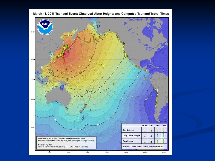
1. 8 m High, ~10 min period 450 NM NE Tokyo, 5685 m deep Deep ocean Assessment and Reporting of Tsunamis
Tsunami caused by uplift of the frontal sedimentary region on eastern margin as the island of Honshu moved 17 feet eastward. Death Toll Missing Total 15, 093 - 5/17/2011 9, 093 24, 186 In Shelters 115, 433 PMEL Source Uplift of ~25 meters
Yamazaki/Cheung UH source for Tsunami Max 25 meter uplift, -2. 8 ft depression 6. 7 meter (22 ft) high. Tsunami in 204 m deep ocean at Iwate GPS Gauge
Run-Up along coast Highest 37. 9 meters = 124 feet
Tsunami Water Levels - Blue Triangle - Run-up Height Red circle: run-up height
Miyako Tsunami Barrier Tsunami Height – 11. 5 meter, Seawall 7. 6 meter Run-up heights of 19. 5 and 25. 5 meter, Over roof of 4 th floor building near coast
Miyako Tsunami http: //www. youtube. com/watch? v=vo. Bsihrae. RO&NR=1
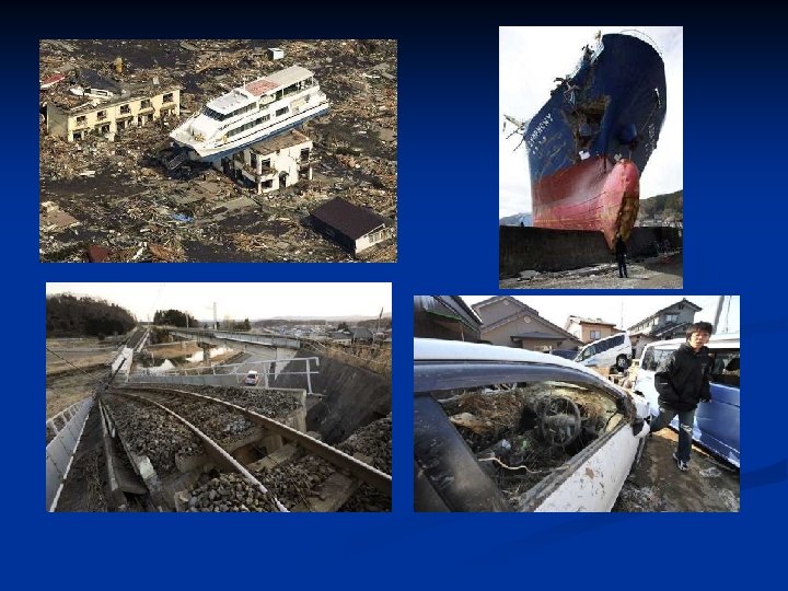
Whirlpool Natori wave strikes homes 901 dead, 145 missing
Natori Tsunami height 12 meter near Sendai airport 9 meter near fishing port Kesennuma Tsunami Heights 9. 10 -14. 7 meters, 16 -22 meter run-up 930 dead, 604 missing
8. 5 meter tsunami height at Miyako tide gauge , 412 dead, 355 missing 8. 0 meter at Ofunato near Tsunami source 314 dead, 150 missing
Rescue from Roof
People on Beer Factory Roof
Kamaishi 7 -9 meter tsunami height 937 dead, 508 missing
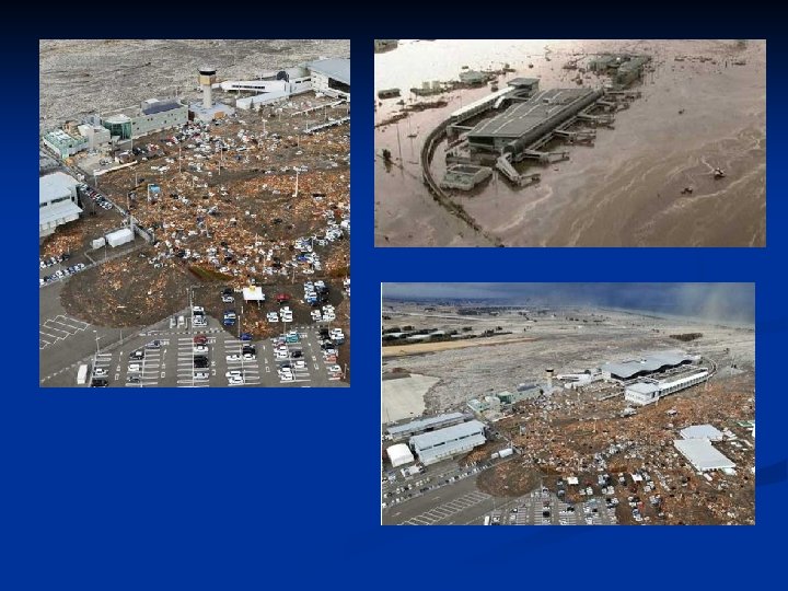
Sendia Airport
Sendai Airport Sendia Airport 3 rd floor
Arahama 9. 3 meter tsunami height
Fujitsuha
Ishinomaki 5 meter in Harbor 16 m runup Ogachi-machi 2964 dead, 2770 missing
Oshika
Kashima 4. 22 meter and 5. 2 meter tsunami height at Kashima Port
Helicopter Views of Japan Tsunami http: //www. youtube. com/watch? v=1 Zp. Fzg. UFjho
Japan Tsunami Flooding Kesennuma http: //www. youtube. com/watch_popup? v=c 3 rq. PPJPw. Lg
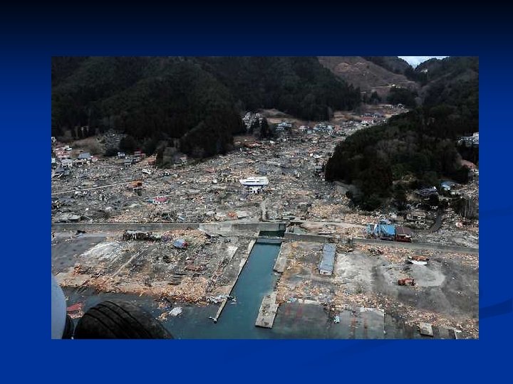
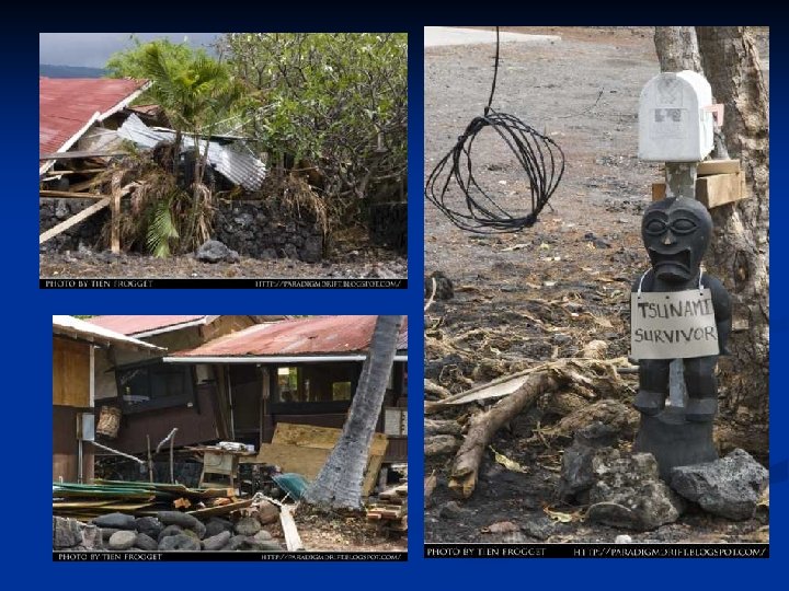
Rikuzentakata The coastline has been totally reshaped. A long barrier beach with well-vegetated land is almost completely gone. North of that flood water sits on agricultural fields. A 6. 5 meter high sea wall was overtopped by a 13 meter high wave, 80% of 8, 000 houses were swept away. Over 18, 000 lost out of 26, 000. The harbor gate failed to shut and 45 firemen where swept away while attempting to close them manually. http: //www. youtube. com/watch? v=-d 6 -l 16 v-f. Q http: //www. youtube. com/watch? v=Scj. Hs 9 b. Clyc
Rikuzentakata Tsunami http: //www. youtube. com/watch? v=Scj. Hs 9 b. Clyc
Rikuzentakata Failed Gate http: //www. youtube. com/watch? v=-d 6 -l 16 v-f. Q
Fukushima Nuclear Power Plant A 150 foot high splash as Tsunami impacts the turbine building, passes over its roof and strikes adjacent reactor building. The lower height structures including the diesel generators are already submerged Plant had a 19 foot high levee. The tsunami wave height was ~46 feet. http: //www. vgb. org/vgbmultimedia/News/Fukushimav 15 VGB. pdf http: //martynwilliams. posterous. com/tsunami-damage-at-fukushima-daiichi
Fudai, Japan and its 3000 residents survived because of a 51 foot (15. 5 meter) floodgate – Run-up of 66 feet (20 meter) on gate towers
Source SWAN Numerical Model of Tsunami reaching Hawaii 2 meter contour
-- 0 ---- T ide
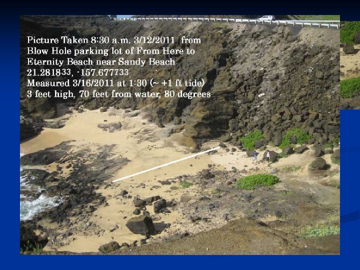
Makaha Beach – Mark Suiso 9 Feet Runup
Dan Walker’s North Shore Survey 17. 5 ft
Haleiwa Harbor 7 Foot Run-up
Keehi Harbor
Keehi Harbor 70% boats damaged or lost
Kona Village Hotel Hales
Kealakekua Bay
Kealakekua Bay
Napoopoo
Napoopoo 16 feet runup Walker
Napoopoo
Kona, Hawaii Tsunami http: //www. youtube. com/watch? v=91 Wh 0_y. NJhc
Crescent City 8 ft high waves
2004 Indian Ocean 2011 Japan Max Run-up 109 feet 125 feet n Death Zone 33 feet 50 feet n Fritz/Meadows 33 feet n EQ Length 1100 km 250 km n Deaths 250 -300, 000 25, 000 n To survive move to above 100 ft ASL, or above 4 th floor if you feel an earthquake or a Tsunami Alert n
www. MCCOHI. COM TSUNAMI Science and Hawaii Hazards Power. Point Files Power. Points with Movies are available on NMWW DVD 12/26/2004 Indian Ocean Tsunami - 300, 000 Deaths 7/8/1955 Lituya Bay 1600 ft High Tsunami 8/27/1883 Krakatoa Volcanic Explosion generated Tsunami Projectile Impact and Explosion Generated Waves Tsunami Hazard for Hawaii Kai, Hawaii Tsunami Hazard from M 9 Earthquake like 12/26/2004 PDF- KT Asteroid Impact - Asteroid Hazard to Life on Earth Dr. Walker Hawaii Historical Tsunami Hazard Evaluation Meadows PDF Report on Hawaii Tsunami Zone Hazards PDF 6/2010 PACON Paper on Hawaii M 9+ Tsunami Hazards 6/2010 PACON Power. Point on Hawaii M 9+ Tsunami Hazards 3/11/2011 Honshu Tsunami Power. Point Tsunami Hazard to Hawaii from Landslides and Asteroids