Moving toward Multispectral Multiplatform Operational Satellite Precipitation Estimates
- Slides: 16

Moving toward Multispectral, Multiplatform Operational Satellite Precipitation Estimates at NESDIS Robert J. Kuligowski Roderick A. Scofield NOAA/NESDIS Office of Research and Applications

Outline n n Brief History of Precipitation Work at ORA Future Directions • Multi-Satellite Blending • Lightning • Multiple-Channel Algorithms • Nowcasting

History: GOES Algorithms n n n Emphasis on operational forecast support (Satellite Analysis Branch) Progression from manual techniques (Interactive Flash Flood Analyzer— IFFA) to automated (Auto. Estimator/Hydro-Estimator) Exploration of multi-channel techniques (GOES Multi-Spectral Rainfall Algorithm—GMSRA)

History: Microwave Algorithms n n n Emphasis on climate applications Progression from statistical algorithms to physical algorithms (Goddard PROFiling algorithm— GPROF) Development of some forecasting applications (TRopical Rainfall Potential—TRa. P)

History: Blended Algorithms n n Resolution and latency favor GOES IR estimates; accuracy favors polar-orbiter MW estimates. Efforts by many researchers to obtain the accuracy of MW with the resolution of IR. Some ORA collaboration with F. Joseph Turk on Naval Research Lab algorithm. Development at ORA of Self-Calibrating Multivariate Precipitation Retrieval (SCa. MPR).

History: SCa. MPR n Flexible framework for automaticallycalibrated precipitation estimation: • Calibrates against SSM/I and AMSU • Discriminant analysis selects and calibrates best rain/no rain predictors • Stepwise forward regression selects and calibrates the best rain rate predictors n Predictors AND calibration updated regularly

SCa. MPR continued: n n SCa. MPR is being transitioned into real-time applications Initial version uses basic predictors: T 6. 9, T 10. 7, T 13. 2, temperature differences, T 10. 7 texture information Eta model PW, RH will be added soon SCa. MPR can use ANY gridded field as a predictor

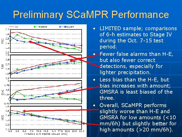
Preliminary SCa. MPR Performance • LIMITED sample; comparisons of 6 -h estimates to Stage IV during the Oct. 7 -15 test period. • Fewer false alarms than H-E, but also fewer correct detections, especially for lighter precipitation. • Less bias than the H-E, but bias increases with amount; GMSRA is least biased of the three. • Overall, SCa. MPR performs slightly worse than H-E and GMSRA for low amounts (<10 mm/6 h) but slightly better for high amounts (>20 mm/6 h).

Blended Algorithms and GPM n Blended algorithms are not intended to compete with GPM ØNo IR algorithm is a perfect substitute for MW! n n Enhanced timeliness and latency in GPM era will enhance combination IR/MW algorithms Ultimate solution is Geo MW, but that remains at least a decade away

SCa. MPR and Lightning n n n Receiving National Lightning Detection Network (NLDN) data in real time Working to design and test lightningbased SCa. MPR predictors Wider applications anticipated with increase in number of spaceborne lightning platforms

Multiple-Channel Algorithms n n GMSRA laid the groundwork, incorporating a number of research techniques into a real-time algorithm: Visible: daytime thin cloud identification 3. 9 µm: retrieving cloud particle size during the daytime (after Rosenfeld and Gutman 1994) 6. 9 µm-10. 7 µm: identifying overshooting cloud tops (after Tjemkes et al. 1997) 10. 7 µm – 12. 0 µm: identifying thin clouds during day or night (after Inoue 1987)

Multiple-Channel Algorithms n n Increased channel selection on current and planned geostationary imagers (e. g. , 12 on SEVIRI, 16 on ABI) Research needs to be transitioned into operations as the data become available, including: • Cloud phase using 8. 5, 11, 12 µm (Ackerman et al. ) • Vertical profiles of cloud water/ice particle size (Chang and Li) n Research is being conducted at ORA using MODIS data for rain/no rain discrimination

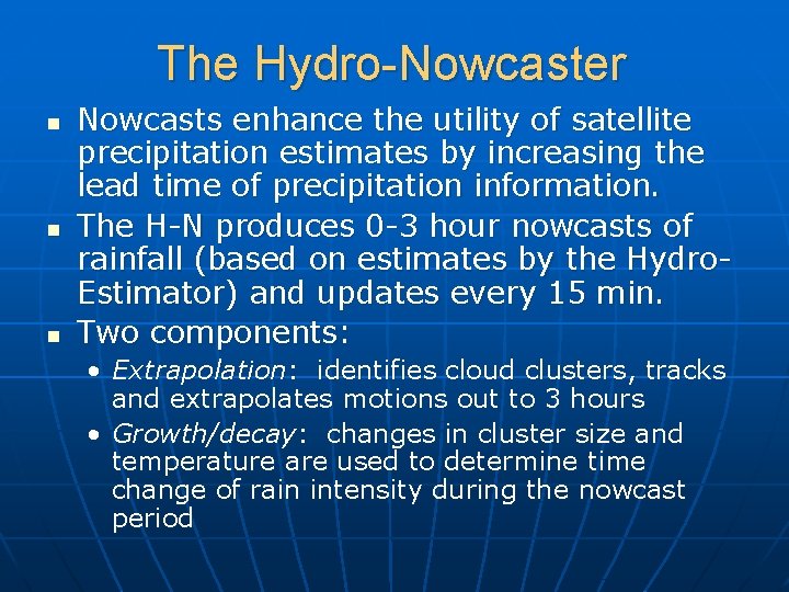
The Hydro-Nowcaster n n n Nowcasts enhance the utility of satellite precipitation estimates by increasing the lead time of precipitation information. The H-N produces 0 -3 hour nowcasts of rainfall (based on estimates by the Hydro. Estimator) and updates every 15 min. Two components: • Extrapolation: identifies cloud clusters, tracks and extrapolates motions out to 3 hours • Growth/decay: changes in cluster size and temperature are used to determine time change of rain intensity during the nowcast period

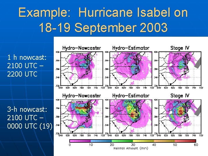
Example: Hurricane Isabel on 18 -19 September 2003 1 h nowcast: 2100 UTC – 2200 UTC 3 -h nowcast: 2100 UTC – 0000 UTC (19)

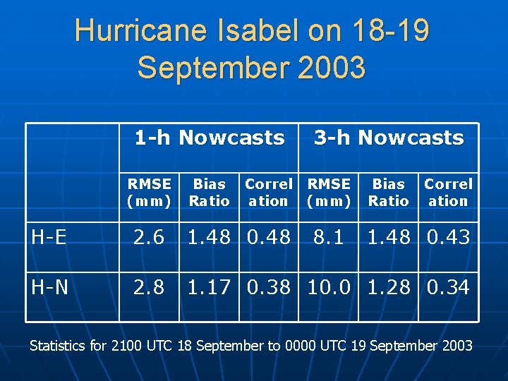
Hurricane Isabel on 18 -19 September 2003 1 -h Nowcasts RMSE (mm) Bias Ratio Correl ation 3 -h Nowcasts RMSE (mm) 8. 1 Bias Ratio Correl ation H-E 2. 6 1. 48 0. 48 1. 48 0. 43 H-N 2. 8 1. 17 0. 38 10. 0 1. 28 0. 34 Statistics for 2100 UTC 18 September to 0000 UTC 19 September 2003

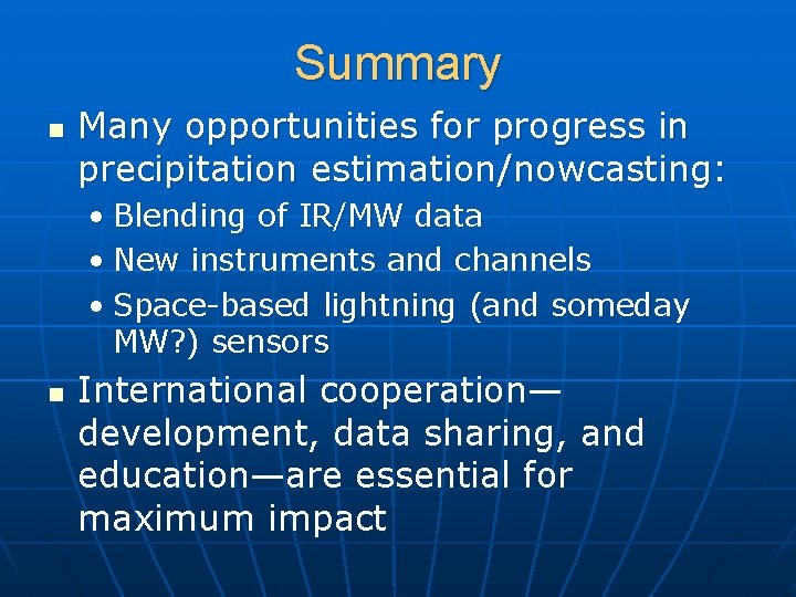
Summary n Many opportunities for progress in precipitation estimation/nowcasting: • Blending of IR/MW data • New instruments and channels • Space-based lightning (and someday MW? ) sensors n International cooperation— development, data sharing, and education—are essential for maximum impact