MOTION IN THE OCEAN Waves Tides and Currents


 SWELL – Long period (boat")


- Slides: 30
MOTION IN THE OCEAN Waves, Tides, and Currents
Waves Ø A disturbance which moves through or over the surface of a fluid Ø Mostly caused by winds (Also earthquakes, volcanoes, grav. pull) Ø Form of great energy
Wave Characteristics Ø Parts of a Wave l Crest = high point l Trough = low point l l Height = vertical distance from crest to trough Wavelength = Horizontal distance between crest to crest or trough to trough
Size of Wind Generated Waves Ø Depends on 3 things: l l l Wind Speed Wind Duration (length of time wind blows) “Fetch” Extent of open water across which the wind can blow
Importance of Waves Ø Shaping Coastlines l l Erode cliffs Grind rock into sand Ø Ecology l l Returns O 2 to water Stir up food for filter feeders
Types of Waves CHOP – Short period (back bays) SWELL – Long period (boat rolls; seasickness) SWASH – water up beach BACKWASH – back down
TSUNAMI “TIDAL WAVE” Caused by undersea quake or volcano • Wavelength = ~150 mi. Can NOT perceive in boat Wave height = 6” – 1’ Speed > 500 mph Slows down to ~25 mph at shore; water builds up to ~65+ ft
Tsunami Waves
Creation of a Tsunami
Tides Ø The rhythmic rise and fall of the ocean’s water High tide = rising, incoming tide, flow Low tide = receding, outgoing tide, ebb Slack tide = vertical movement stops
Ø Tides are very long, slow waves l l l They have a wave period of 12 hours 25 min Tidal day is 24 hours 50 min NJ has 2 high and 2 low tides daily
What Causes Tides? 1. Gravitational pull of sun & moon on Earth • Moon closer, therefore > effect • Like magnet, pulls water away from surface = TIDAL BULGE
Types of Tides • Spring Tide - Moon and sun are in direct line with one another - Results in unusually high tidal range -Tidal Range = vertical distance between high & low tides l 2 x’s/month
Ø Neap Tide l l sun and moon are at right angles Pulls cancel each other out – causes a weak pull unusually low tidal range 2 x’s / month
Spring vs. Neap Tides
Types of Tides Continued Ø Diurnal Tides l 1 high & 1 low / day l Parts of Gulf of Mexico and Asia Ø Semi-Diurnal Tides l 2 high & 2 low / day l Atlantic coasts of North America and Europe Ø Mixed l 2 high & 2 low / day (height varies) l Pacific coast
Importance of Tides • Expose & submerge orgs • Circulate water in bays & estuaries • Circulates food, wastes, etc • Trigger spawning (grunion, horseshoe crab)
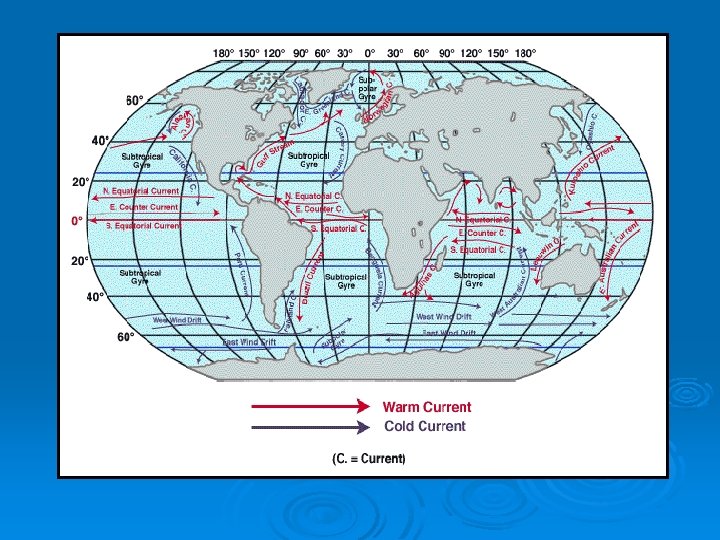
Currents • What are currents? - “Rivers” of circulating water • Causes - Wind - Rotating Earth - Density Changes
Surface Ocean Currents • Broad, slow drifts; never cross equator • Wind generated; circular patterns
• Coriolis Effect - N. Hemis – clockwise; Right - S. Hemis – counterclockwise; Left
• Gulf Stream - N. Atlantic - Brings warm water from equator north along east coast of N. A. -Sometimes form eddies – circulating water that pinches off from the current
NAVIGATION MIGRATION WEATHER
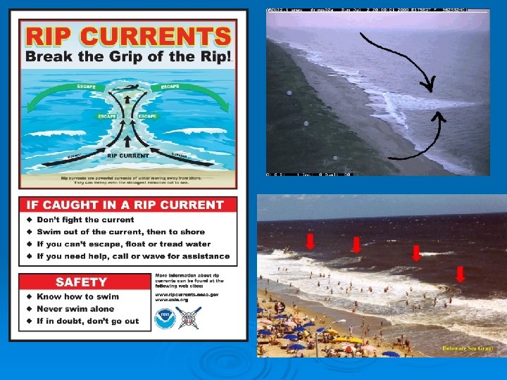
Localized Surface Currents Longshore Current. l Flows parallel to shore; move sediment
RIP CURRENT - Caused by converging longshore currents - Very dangerous ; Red Flag - DO NOT fight rip current; swim parallel to shore to get out of channel
Deep Ocean Currents ØFlow beneath surface; cross equator ØMove North to South Ø Separated from surface currents by boundary called a “Thermohaline” (diff in densities)
Importance Of Deep Currents l Upwelling • Brings deep water to surf. • Circulates nutrients up • Moves plankton & larvae