Moisture Clouds and Precipitation Chapter 18 Water In


- Slides: 52
Moisture, Clouds, and Precipitation Chapter 18
Water In The Atmosphere �Water Vapor �Source of all Condensation and Precipitation �Most important gas in the atmosphere �Only makes up about 4% of atmosphere
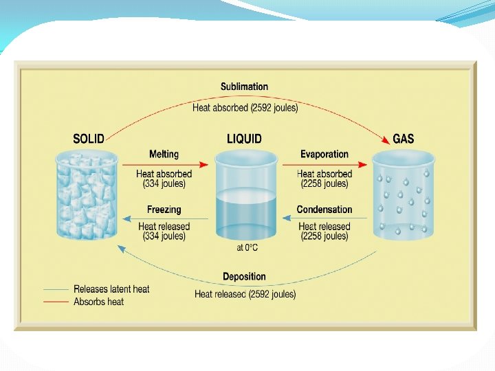
Water’s Change Of State �Present in all states �Solid, Liquid and Gas �Changes states as it goes through water cycle �Passes through atmosphere as gas (water vapor) �Atmosphere holds enough water vapor to cover globe in 2 mm deep layer
Solid To Liquid - Melting �Energy must be transferred in form of heat �Ice water stays at 0 degrees until all ice has melted �Energy added is used to break apart crystals in ice �Latent Heat �Heat used to melt ice didn’t produce temperature change – it was hidden �This hidden energy gets stored in liquid water �Won’t get released until liquid returns to solid �This is the energy source for storms
Liquid to Gas - Evaporation �Energy absorbed during evaporation gives water molecules enough motion to escape surface of liquid and become gas �Known as Latent Heat of Vaporization �When you step out of shower and are freezing it is because the water on your skin is evaporating �The energy needed to cause evaporation is coming from your skin �Your skin then feels cooler
Gas To Liquid - Condensation �Makes clouds and fog �Water molecules have to release energy �Latent Heat of Condensation �Violent storms happen when a lot of this energy is released at once
Solid to Gas �Sublimation �Skips liquid phase �Dry Ice is frozen carbon dioxide �When exposed to room temperature it sublimates to gaseous state �Deposition �Water vapor goes directly to solid �Frost
Humidity �Amount of water vapor in the air �Saturation �Think of jar with lid on that is half full of water and the rest is dry air �The water will evaporate causing movement in molecules of dry air �When more molecules escape liquid water the pressure increases �This forces some molecules to condense �When the number of molecules evaporating are equal to the number of molecules condensing the air is said to be saturated �Warm air holds more water vapor than cold air (pg 506)
Relative Humidity �The ratio of the air’s actual water-vapor content compared with the amount of water vapor air can hold at that temperature and pressure �Measures how near the air is to saturation �Does not measure quantity of water vapor in air �Can change in two ways �Add or remove water vapor �Change temperature
Relative Humidity
Dew Point �Temperature that air has to cool to in order to reach its saturation point �During summer, since warm air can hold a lot of water vapor, the warm days mean a lot of moisture in air �When sun goes down the air cools �Cool air can’t hold as much water vapor so it condenses and we wake up with dew covered surfaces �High Dew Point = moist air �Low Dew Point = dry air
Measuring Humidity �Hygrometer �Psychrometer �A type of hygrometer �Has two thermometers � One wet-bulb � One dry bulb
Measuring Humidity �How A Psychrometer Works �Air must continually pass over bulb �Water evaporates from wet bulb �The heat absorbed by evaporation causes wet-bulb temperature to drop (like your skin getting cold after shower) �Amount of cooling is directly related to amount of water vapor in air � Dry air will cause more evaporation and greater drop in temperature �Use standard tables to determine relative humidity
Relative Humidity Table – pg 525
Why is Winter Air Dry? �Water vapor content of air stays constant �Warm air holds more water vapor than cold air �In winter outside air is cold so it doesn’t hold a lot of moisture �When you pump that air into your house and warm it up the relative humidity drops to less than 10% �Causes static electricity, dry skin, sinus headaches, etc.
18. 1 Review �What is the most important gas for understanding atmospheric processes? �What happens to heat during a change of state? �How does the temperature of air influence its ability to hold water? �List two ways relative humidity can be changed? �What does relative humidity describe about air? �If the dew point is low, is the air moist or dry?
Cloud Formation �Clouds form when air is cooled to its dew point �Air must be saturated �But these clouds form during warmest part of day – so how is that possible?
Air Compression and Expansion �Think of pumping up bicycle tire �When you put air in the hose gets warm �Compressing air increases motion of gas molecules �This causes temperature to rise �Tire losing air �When air is released it expands and cools �Adiabatic Temperature Changes �Changes that happen even though heat isn’t added or subtracted
Expansion and Cooling �As you go higher in atmosphere pressure decreases �With less pressure a parcel of air is able to expand as it moves higher �Dry Adiabatic Rate �Rate of cooling for unsaturated air � 100 C/1000 meters �Eventually parcel of air reaches its dew point �Latent heat is released and clouds form �Wet Adiabatic Rate �Rate of cooling for saturated air � 50 C/1000 meters
Adiabatic Cooling
Processes That Lift Air �Air would prefer not to move around �Four mechanisms cause air to rise �Orographic Lifting �Frontal Wedging �Convergence �Localized Convective Lifting
Orographic Lifting �Elevated terrain acts as barrier �Causes air to rise and reach dew point �Clouds form and it rains on windward side �Other side of barrier is dry because all of precipitation fell out �Air descends and warms up making it even drier �Rain Shadow Desert forms
Frontal Wedging �Warm air meets cold air and a front forms �Warm air is less dense so it rises over cold air
Convergence �When two air masses run into each other the air has to go somewhere �It can’t go down so it has to go up �Leads to adiabatic cooling and possible cloud formation �This is why it rains many afternoons in Florida
Localized Convective Lifting �Unequal heating of Earth’s surface can cause pockets of air to be warmed more than others �Rising parcels of air are called thermals �Birds use this to soar high in sky �People use it when they want to go hang gliding �If parcel rises above condensation level then clouds form and may produce rain
Stability �Stable air resists vertical movement �Stable when air is cooler than surrounding environment �This means it is more dense and doesn’t rise up to form clouds or cause precipitation �Stable air tends to remain in original position �Unstable air tends to rise – it is warmer and less dense than its surroundings
Stability Measurements �We can tell if air is stable by knowing temperature of the atmosphere at various heights �Measured using aircraft and radiosondes �Environmental Lapse Rate �Rate of change of air temperature with height
Degrees of Stability �Stable air �Temperature decreases gradually with increasing altitude �Temperature inversion �Most stable air �Temperature increases with height �Happens on clear nights �Earth cools off quickly and air at surface is cooled while air above surface is still warm
Stability and Daily Weather �Stable air �You wouldn’t think clouds would form if air was stable �But, remember, other processes cause air to lift �When this happens clouds are usually widespread with little vertical thickness �Precipitation, if any, is light to moderate �Unstable air �Towering clouds with powerful storms
Condensation �Air must be saturated and there must be a surface for the water vapor to condense on �Known as Condensation Nuclei �Usually microscopic particles of dust, smoke or salt �Water condenses and forms clouds, but they are so small they are still light enough to remain in the air �So a cloud is made of millions and millions of tiny water droplets
18. 2 Review �Describe what happens to air temperature when work is done on the air to compress it. �What does stability mean in terms of air movement? �What are the four mechanisms that cause air to rise? �Describe conditions that cause condensation of liquid water in air. �What is a temperature inversion? �Hypothesize about other regions on Earth, other than the Florida peninsula, where convergence might cause cloud development and precipitation.
Clouds �Visible mixtures of tiny droplets of water or tiny crystals of ice �Show what is going on in the atmosphere �Knowing the characteristics of cloud types helps you predict the weather. �Types based on form and height
Cloud Form #1 - Cirrus �High, white and thin �Occur as patches or veil-like sheets �Wispy fibers give feathery appearance
Cloud Form #2 - Cumulus �Rounded individual cloud mass �Usually have flat base and rise as domes or towers �Fluffy tops described as cauliflower head
Cloud Form #3 - Stratus �Sheets or layers that cover the sky �No distinct units �Usually bring precipitation
Cloud Height #1 – High �Base above 6000 meters �Cirrus, cirrostratus and cirrocumulus �Thin and white �Made of ice crystals �Usually no precipitation �If followed by cirrocumulus or cirrostratus may warn of approaching storm
Cloud Height #2 - Middle � 2000 – 6000 meters �Prefix “alto” as part of their name �Altocumulus are larger and denser than cirrocumulus �Altostratus are white or grayish sheet covering sky �Often accompanied by light snow or drizzle
Cloud Height #3 - Low �Form below 2000 meters �Stratus, stratocumulus and nimbostratus �Uniform, fog-like layer �Covers most of sky �Nimbostratus main precipitation makers �Form in stable air when air is forced up
Clouds of Vertical Development �These don’t fit in any of the other categories �They may start in one layer and extend into another �Form in unstable air �Cumulus are usually fair weather but grow out of control under right circumstances – become cumulonimbus �Produce rain or thunderstorms
Fog �A cloud with its base at or very near the ground �Physically same as cloud �Difference is method and place of formation �Clouds form when air rises �Fog forms three ways �Radiant cooling �Movement of air over cold surface
Fogs Caused by Cooling �Warm moist air over Pacific moves over cold California Current then carried onshore by prevailing winds �Cool, clear, calm nights air near surface of Earth cools when Earth loses heat gained during day and reaches its dew point �As the air cools it becomes dense and sits in low areas
Fogs Caused By Evaporation �Cool air moves over warm water �Water evaporates from surface and air above reaches saturation �Known as Steam Fog �Most common in fall and early winter
How Precipitation Forms �Cloud droplets <20 micrometers in diameter �This size would fall too slow �Would also evaporate before it hit the ground �Two Processes �Bergeron Process �Cold clouds �Collision-Coalescence Process �Warm clouds
Cold Cloud Precipitation The Bergeron Process �Supercooling �Cloud contains water vapor, ice crystals and water droplets �Water droplets below freezing point �Don’t freeze because there are too few freezing nuclei �Water condenses on ice crystals �Eventually crystals are heavy enough to fall �If surface temp is above 4 OC the crystals melt on their way down and fall as rain
Warm Cloud Precipitation Collision-Coalescence Process �Coalescence �Cloud droplets fall �Collide and combine with smaller droplets �Drops become too large to stay suspended and fall as rain Usually in tropics
Liquid Forms of Precipitation �Rain �Size: 0. 5 -5 mm diameter �Drizzle �Size: <0. 5 mm diameter �Falls very slow
Solid Forms of Precipitation �Snow �Ice particles �Usually falls as flakes �small flakes at low temps �larger flakes closer to freezing �depends on moisture content in air
Solid Forms of Precipitation �Sleet �ice pellets �rain falls through layer of freezing air
Solid Forms of Precipitation �Freezing Rain �Glaze Ice �Rain doesn’t freeze until it strikes surface near ground
Solid Forms of Precipitation �Hail �Usually in cumulonimbus cloud �Raindrops carried high in cloud by convection current – freezes Falls – gathers more precipitation Carried back up by updraft
18. 3 Review �How are clouds classified? �Compare and contrast clouds and fog. �What must happen in order for precipitation to form? �Describe how the temperature profile of air near Earth’s surface controls the type of precipitation that falls to the ground. �Identify the following cloud types as producers of heavy, light, or generally no precipitation: �Cirrocumulus �Stratus �Cumulonimbus �nimbostratus