Module 4 Monitoring data and indicators Sessions at


 1. In pairs, reflect on a participatory process that")
 In plenary… • What did you notice or learn")


; large in volume (databases,")


 Develop a plan for data collection, considering, a. What type")
. State of")


 • In groups of 3– 5,")


 •")


 • Step 1. In plenary, develop")
 • Step 3. In sub-groups, prepare")
 • Step 5. Identify the data")


 In plenary, • How do you feel")

 • Construct a")


 As GDP per capita increases, so does environmental performance")

 • In groups of 3– 5, envision an")


 In small groups, discuss the following questions. 1. Using")
 2. Give examples of other spatial data layers that")
- Slides: 94
Module 4: Monitoring, data, and indicators
Sessions at a Glance Session 1: Introduction Session 2: Developing Data for IEA Session 3: Information Systems Session 4: Indicators and Indices Session 5: Data Analysis
Knowledge gained from data is fundamental to our understanding of environmental issues as well as for communicating information to policy-makers and other groups in society. However, without good quality, relevant data and indicators, the assessment loses not only valuable communication tools, but also credibility and the ability to measure progress towards sustainability goals and objectives.
Objectives of Module 4 • understand the roles and uses of data, indicators and indices in integrated environmental assessment • know how to develop strategies for collecting and validating data • understand how indicators and indices are developed and used • be able to analyse indicators and index outcomes • be able to communicate and present statistical and mapbased data visually
Sessions at a Glance Session 1: Introduction Session 2: Developing Data for IEA Session 3: Information Systems Session 4: Indicators and Indices Session 5: Data Analysis
Why Measure? Societies measure what they care about on the following basis: If you can't measure it, you can't manage it !!
Data and Indicators • Data are neutral facts • Indicators inform our decisionmaking They are derived from data.
A Framework for Data Flows
Continuum from Data to Indices: From Narrow to Broad Views Increasing Synoptics and Integration Composite Indices Simple Indices Indicators Profiles Disaggregated Indicators Integrated Databases Disaggregated Data + Statistics Total Quantity of Information
What are the relevant issues? • • Desertification Water resources Climate change Quality of the urban environment • Eutrophication • Biodiversity • • • Fish resources Toxic contamination Forest resources Oil resources Disposal of waste Depletion of the ozone layer • Acidification etc.
Prioritize the issues Criteria for Issue Selection Urgency and immediate impact Irreversibility Effects on human health Effects on economic productivity Number of people affected Loss of aesthetic values Impacts on cultural and historical heritages Theme and Issue
Participatory Process …at all stages of indicator development. Questions to Ask: Who needs to be consulted? What are the most appropriate levels of participation? What are the most relevant stages of the process? What are the most efficient and effective mechanisms, given available resources? How will input from those consulted be used and reported?
Discussion: Participatory Processes (15 minutes) 1. In pairs, reflect on a participatory process that you led or were involved in that had successful elements. Use the following questions to help focus your discussion. • Why was using a participatory approach in the project important? • When in the project was a participatory approach used? • What were the main techniques? • What parts of the process worked well? • What were some of the challenges? How were these challenges overcome?
Discussion: Participatory Processes (10 minutes) In plenary… • What did you notice or learn from your conversations? • What features of the project worked well? • How were you able to overcome barriers?
Sessions at a Glance Session 1: Introduction Session 2: Developing Data for IEA Session 3: Information Systems Session 4: Indicators and Indices Session 5: Data Analysis
What are DATA? Graphs Maps Images Videos Tables Pictures
In this session… • Types of data • • Quantitative Qualitative Spatial data Non-spatial data • Data monitoring, collection and storage • GEO Data Portal
Qualitative Data Socially-derived information strengthens EIA by relating to the practical “real-world” dimension of the environment. Qualitative methods can include: Ø field observation; Ø interviews with people who live in local environments; Ø narrative, descriptive, oral histories, and interpretive sources
Qualitative Data as a Complement to Quantitative Data • Broadens the scope of environmental inquiry to include people’s experiences, perspectives and perceptions; • Makes use of critical environmental information before it shows up on the scientific or public radar; • Integrates indigenous or other groups into formal environmental discussions and decision making; and • Acknowledges the role of perception in human response to environmental conditions.
Quantitative Data Possible characteristics: • • • geographic locations (coordinates); large in volume (databases, reports, etc. ); from a variety of often heterogeneous sources; variability of resolution (details) and scales; a high degree of complexity; are needed at varying temporal frequency (e. g. , hourly, daily, monthly, yearly; • available in varying forms and formats; and • available in digital or electronic versions.
Forms of Quantitative Data • maps • remotely sensed data such as satellite imagery, aerial photographs, or other forms of data • computer data files • drawings • reports and documents • bibliographies • videos and films • graphs and charts • tables • computer animated images
Primary vs. Secondary Data • Very few assessment processes have the mandate, resources and capacity to collect primary data. • Many processes relay on data collected by others. • Compiling data usually means collecting data from many different sources.
Characteristics of Non-spatial Data… …collected for one point and results in a single number; …can not be further broken down; …can have temporal resolution if collected continuously over a period of time from a specific geographical point; …can be obtained from statistical sources or isolated research.
Spatial Data… • describes the distribution of phenomena and artefacts; • is used to identify the location and shape of, and relationships among, geographic features and boundaries; • is often displayed as layers of data; • presents a very immediate and visual message regarding environmental issues and management.
Georeferenced Data or Indicators Examples of layers you might use: • aerial photography • protected natural areas • satellite imagery • habitat regions • country boundaries • lakes and rivers • local • elevation administrative contours boundaries • streets • climate data • cities • soil layer data • utilities • wildlife populations Layers of Spatial Data
Satellite Imagery Lake Tonga, Africa 1995 2000 Source: UNEP Grid – Sioux Falls http: //grid 2. cr. usgs. gov/Africa. Lakes/Atlas. Download/Africa_Lakes
Aerial Photography
Monitoring and Data Collection of Environmental Trends and Conditions • Monitoring provides tangible information on a regular basis over an extended period of time about past and present conditions of the environment. • Monitoring can be used to evaluate the performance and effectiveness of policies implemented and actions taken.
The Challenge of Coordinated Monitoring Systems • There is a critical shortage of comprehensive, harmonized, high quality data that are readily available for analysis of environmental issues. • IEAs can have an important role in identifying the most important data gaps, and providing feedback to monitoring and observation programmes.
Data Collection Steps 1) Develop a plan for data collection, considering, a. What type of data is needed? b. What data needs are higher priority? c. What are the criteria for data collected, including quality and cost? 2) Survey data availability for the different components of your assessment.
Steps for Data Collection and Compilation Source: UNEP/DEIA, Rump, P. C. (1996). State of the Environment Reporting: Source Book of Methods and Approaches. UNEP/DEIA/TR. 96 -1, UNEP, Nairobi.
Data Quality Considerations • Data quality must be sufficient to satisfy objectives. • Use proxies (imperfect approximations) if no direct data can be obtained (e. g. CO 2 emissions to show climate change). • Use best available, scientifically sound data from widely recognized sources.
Storing Data in an Indicator Database • A database is an organized collection of data. • To keep the database up to date, link it electronically to monitoring systems. • A database can be used to prepare reports for use by policy-makers and the public. • Building a database can be a collaborative effort.
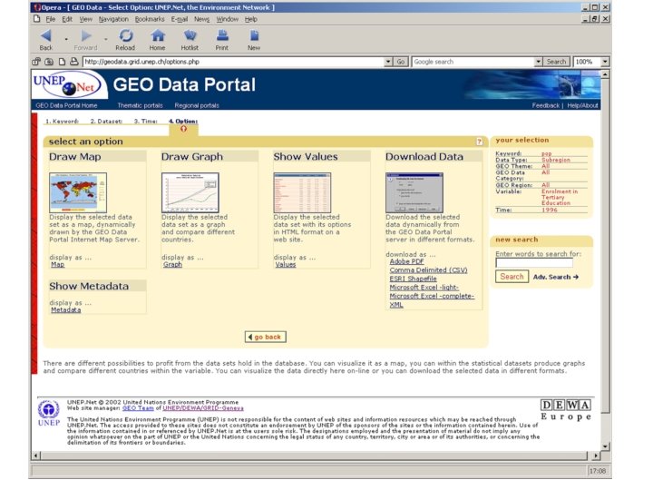
Finding Data Online • Some environmental and socio-economic data is available for free on the Internet. • Many online data and map services are simple to use with most Internet browser programs. • The GEO Data Portal provides data from authoritative international sources to the assessment community. (http: //geodata. grid. unep. ch)
GEO Data Portal What is GEO Data Portal? An authoritative source of data used by UNEP and partners in the GEO reporting process and other integrated environmental assessments. What does the GEO Data Portal do? – Gives access to a broad collection of harmonized environmental and socio-economic data sets from authoritative sources from global, regional, subregional and national levels. – Enables mapping and analysis.
GEO Data Portal What themes are present? – climate, disasters, forests, freshwater – education, health economy, population, environmental policies Who uses the GEO Data Portal? – UNEP Offices, GEO Collaborating Centres, contributors – Universities, schools, civil society and general public
GEO Data Portal Who provides data to the Portal? – FAO, UNEP, UNESCO, UN Statistical Division, World Bank, OECD Are there regional versions of the Portal? – Yes, in Latin America and Africa – Soon to follow are Asia Pacific and West Asian Where can I access the Portal? By website: http: //geodata. grid. unep. ch/ By CD-Rom: http: //www. grid. unep. ch/wsis/
Exercise: Visualizing Data Needs and Uses (20 min) • In groups of 3– 5, discuss how each person has used spatial data to describe an environmental issue. • Describe the data analyses that were conducted and the uses of those analyses. • What worked well and what did not in that process?
Indicators and Indices • • • Session 1: Introduction Session 2: Developing Data for IEA Session 3: Information Systems Session 4: Indicators and Indices Session 5: Data Analysis
In this Session… • • • Selecting good indicators Participatory processes Indicator frameworks Indicator development Core indicator sets Indices
Why Indicators? • Indicators make data relevant for society and policy making. • They help us understand what is happening around us. • As a society, we tend to choose measures that reflect our values. • At the same time, information we receive also shapes what we value.
The Value of Indicators in Policy Making Indicators have the potential to… ü provide feedback on system behaviour and policy performance; ü improve chances of successful adaptation; ü ensure movement toward common goals; ü improve implementation; and ü increase accountability.
The Challenge of Selecting Good Indicators Challenge #1: Indicators can provide misleading and inaccurate information about what is being measured. Meeting the challenge: Ø Ensure the indicator reflects the knowledge being sought. Ø For example, example if knowledge about change over a short term is sought, avoid giving data that reflects change over a long term.
The Challenge of Selecting Good Indicators Challenge #2: Select the appropriate number of indicators. Too many indicators may create “noise” that is difficult to interpret, while too few indicators limit the scope of understanding. Meeting the challenge: Select indicators based on a select set of priority issues as a way of limiting the number of indicators and ensuring the indicators are relevant.
The Challenge of Selecting Good Indicators Challenge #3: A good indicator may have limited data availability; a poor indicator may have great data availability. Meeting the challenge: Ø The goal is to select indicators with the best possible fit to the IEA. Ø While data availability is an important consideration, it is one of a number of criteria that should influence the selection of indicators.
The Challenge of Selecting Good Indicators Selecting indicators can be a balancing act, with trade-offs such as ensuring relevance to society and policy-makers, using data that is scientifically sound accurate, and relaying data in a way that is easily interpreted.
Some Indicator Criteria… ü easy to understand interpret ü shows trends over time ü scientifically credible ü based on high-quality data ü policy relevant ü politically acceptable Based on World Bank (1997) and OECD (1993)
Participatory Process at Multiple Stages of Indicator Development
Orienting Indicators to Conceptual Frameworks The orientation of indicators to issues as well as relationships among indicators (such as cause-and-effect relationships) is often structured using conceptual frameworks.
Framework Example 1: DPSIR • Driver – Pressure – State – Impact – Response • Shows relationships between human activity and ecosystem well-being and is used for GEO - 4.
HUMAN SOCIETY DRIVERS PRESSURES Direct influence through human interventions Sectors: Indirect influence through human development IMPACTS Human well-being RESPONSES Mitigation and adaptation Human influences: Economic, social goods & services Ecosystem Services Natural processes: STATE AND TRENDS Water, land, atmosphere, biodiversity ENVIRONMENT Step 1 What is happening to the environment and why? Step 2 What are the consequences for the environment and humanity? Step 3 What is being done and how effective is it?
HUMAN SOCIETY DRIVERS WATER RESOURCES Population growth PRESSURES Direct influence through human interventions Agriculture Discharge of fertilizers and pesticides Nutrient loading and eutrophication IMPACTS Well-being RESPONSES N and Pauingassi regulation Infrastructure Bottled water -Access to clean water - Nourishment - Health Services -Fresh water - Food -Recreation STATE AND TRENDS Lake water quality declining ENVIRONMENT Step 1 What is happening to the environment and why? Step 2 What are the consequences for the environment and humanity? Step 3 What is being done and how effective is it?
HUMAN SOCIETY DRIVERS AIR QUALITY Population Growth PRESSURES IMPACTS Direct influence through human interventions Well-being - Health - Infrastructure Transportation Emissions from motor vehicles Smog, acid rain, dust RESPONSES Vehicle emission standards Traffic reduction measures Air quality indexes and advisories Services -Clean air -Clean water - Food STATE AND TRENDS Urban air quality declining ENVIRONMENT Step 1 What is happening to the environment and why? Step 2 What are the consequences for the environment and humanity? Step 3 What is being done and how effective is it?
HUMAN SOCIETY DRIVERS Energy Demand PRESSURES Direct influence through human interventions Petroleum / Oil and Gas Oil spills Contamination Toxic effects Smothering COASTAL AND MARINE WATER IMPACTS Well-being RESPONSES Oil spill clean up Oil tanker technology incentives - Health - Recreation - Tourism - Fisheries Services - Clean water - Biodiversity STATE AND TRENDS Coastal water quality declining. ENVIRONMENT Step 1 What is happening to the environment and why? Step 2 What are the consequences for the environment and humanity? Step 3 What is being done and how effective is it?
DPSIR in Summary • DRIVERS: fundamental processes in society that drive activities having a direct impact on the environment; • PRESSURES: human interventions (intentional or unintentional) in social and economic sectors of society that result in environmental change; • STATE: environmental state and trends, often referred to as environmental change, which could be both naturally and human induced. • IMPACTS: changes that may positively or negatively influence human well-being through changes in ecological services and environmental stress; and • RESPONSES: elements among the drivers, pressures and impacts which may be used for managing society in order to alter the human –environment interactions.
Indicator Development Example from South Africa
Indicator Development Example from South Africa • Step 1: Identifying a framework to guide the selection of indicators. – In South Africa the framework was based on a review of environmental and local government legislation, and consultation with stakeholders. It was built around core environmental mandates for local government, and if a core mandate was not present, then around the role of provincial and national government. • Step 2: Drafting a set of indicators based on a set of criteria for indicator selection. – The draft set of indicators in South Africa was reviewed by local, provincial and national government, to ensure that the new indicators would have as consistent a format and language as pre-existing indicators. A workshop was then held to obtain feedback from stakeholders. • Step 3: Categorizing the indicators. – Because municipalities and provinces across South Africa manage areas with different characteristics, and with different levels of resources, capacities, knowledge and available data, further categories were needed to reflect these differences. The indicator categories were then placed within the indicator framework.
Core Indicator Sets • core indicators sets are limited in number and clustered around themes; • they provide clear and straightforward information to decision-makers; • they do not provide a comprehensive picture or show relationships between indicators; • examples include OECD, UNEP (UNCSD), EU Structural Indicators, and GEO Core Data Matrix.
Themes from the GEO Core Data Matrix Ø land Ø forests Ø biodiversity Ø fresh water Ø atmosphere Ø coastal and marine areas Ø disasters Ø urban areas Ø socio-economic Ø geography
Sample Indicators from the GEO Core Indicator Data Matrix Theme Issue Potential Data Variables Proposed Lead and Key Indicators Land Soil Water erosion (000 tonne/ha) Wind erosion (000 tonne/ha) Average annual soil erosion rate Erosion Area affected by Total land affected by desertification (000 ha and %) desertification of rain-fed croplands, irrigated land, forest and woodlands Land salinization Areas affected by salinization Total area affected by and waterlogging (000 ha and salinization and change)
UN DSD Indicator Framework • Developed in response to Agenda 21 (Chapter 40) • Original workplan included a list of 130 indicators organized using the Driver – State – Response framework • As a result of testing the indicators, the number of indicators was reduced to 58 and the DSR framework was replaced by a thematic “four pillars” framework.
Sample Indicators from the UN-DSD Framework Social Theme Sub-Theme Indicator Equity Poverty Percent of population living below the poverty line Gender Equality Ratio of Average Female to Male Wage Health Nutritional Status for Children
Indicator Methodology Sheets …developed for each selected indicator Definition of indicator Type of indicator Underlying definitions and concepts Unit of measurement Measurement methods Data needed to compile indicator Data sources References
Theme: Water Issue: Water Pollution Indicator: Percent of Population with Adequate Sanitary Facilities Definition of indicator Proportion of population with access to a sanitary facility in the dwelling or immediate vicinity. Type of indicator State Underlying Definitions and Concepts Sanitary facility: (definition of a suitable sanitary facility) Population: (i. e. , includes rural and urban) Unit of Measurement % Measurement methods May be calculated as: # people with improved disposal facilities available (X 100) / total population Data needed to compile The number of people with access to improved sanitary facilities and total population. indicator Data sources Routinely collected at national and sub-national levels in most countries. Include administrative bodies where information can be found. References Key references for indicator development.
Exercise: Identifying Indicators and Data Sets (30 minutes) • Step 1. In plenary, develop a list of short themes required to develop the assessment report. ØPrioritize themes according what might be most relevant for GEOLand at this time. ØForm smaller groups, and assign a theme to each group.
Exercise: Identifying Indicators and Data Sets (30 minutes) • Step 3. In sub-groups, prepare a list of issues related to theme of your group. • Step 4. Identify indicators that correspond to each issue. Ø Brainstorm a larger list, and then narrow down your list using indicator criteria. Ø Indicate whether the indicator is a driver, pressure, state, impact or response in the DPSIR framework.
Exercise: Identifying Indicators and Data Sets (30 minutes) • Step 5. Identify the data you will need for the indicator. There a number of data sources you may wish to consult. o OECD’s “Selected Environmental Data” document at http: //www. oecd. org/dataoecd/11/15/24111692. PDF. o GEO Data Portal. o FAO Statistical databases (FAOSTAT, Aquastat, Fishstat, Terrastat). o Others listed in the database section of this report. o Materials: A sample of the question completed to help orient participants and trainers.
What are Indices? • Consist of multiple indicators combined into a composite or aggregated unit • Are often used to assess and compare performance against benchmarks or among performers • If using to inform policy, it is paramount that the indicators are well constructed and accurately interpreted
Considerations about Indices • Indices have a broad scope and can result in overlooking specific issues that are reflected in specific indicators. • An index is based on the best available data, which means that indicators for which there is no data will not be included. • Correlation among different indicators should be avoided so that certain issues are not amplified in the index.
Constructing an Index • Indicator data is standardized, such as converting all indicators to a scale of 0– 100, so they can be aggregated; • Indicators are sometimes assigned relative weights so that some indicators are given more emphasis in the index; • Assigning weights can be based on policy relevance, societal values or on quality and quantity of data.
Examples of Well-Known Indices • Gross Domestic Product • Human Development Index • Environmental Performance Index
Air Quality Index
Discussion: An Air Quality Index (10 minutes) In plenary, • How do you feel a policy-maker or manager might need to communicate about air quality? • What indicators would be appropriate to include in an Air Quality Index? • Based on the air quality indicators in the module, what indicators would you have included or excluded?
Exercise: Calculating a Model Air Quality Index for Countries • Background: – Often a single air quality index is a composite of many indicators on air quality – When direct measurements are not available, proxies are used, such as the use of emissions when air concentrations are not available.
Exercise: Calculating a Model Air Quality Index for Countries (30 minutes) • Construct a virtual Air Quality Index for a country, using Kenya as an example • Use the GEO Portal to obtain data on air quality in Kenya in 1995
Sessions at a Glance Session 1: Introduction Session 2: Developing Data for IEA Session 3: Information Systems Session 4: Indicators and Indices Session 5: Data Analysis
Data Analysis • Non-spatial data analysis • Spatial data analysis • Linkages to Module 7 on physical presentation of data
Non-Spatial Analysis • Performance evaluation – Baseline – Targets – Thresholds • Science, policy and societal values all influence the development of performance indicators, making it a challenging task.
Trend Analysis: What it is • Allows us to understand changes in performance over time • Trends can be presented in ways that result in different interpretations, such as: – indicators presented as an absolute value, a percentage or an index – difference in scale on the Y-axis
Trend Analysis: Examples Population-Estim. &Proj. Source: FAOSTAT 2005 Qatar
Trend Analysis: Patterns Graph 1: Erratic Pattern Graph 2: Stable Pattern The data is the same for both graphs… the difference is the scale on the Y-axis.
Correlation Analysis …identifies degree of similarity among variables using statistics …does not imply cause and effect …can be positive or negative
Example: Environmental Performance Index (EPI) As GDP per capita increases, so does environmental performance from a policy perspective. This is a positive correlation.
Presenting Indicators Using Symbols Visually show performance of an indicator using easily understood symbols. Example from United Kingdom Headline Indicators
Discussion: Communicating an index (10 min) • In groups of 3– 5, envision an effort to communicate a trend in one environmental issue (e. g. , air quality). • Describe three approaches you might use and describe the strengths and weaknesses of each.
Further Questions for Discussion • Who are the different audiences that would see the indicators? • What information needs does each audience have? • What are some ways you can provide the technical information needed while at the same time making the indicators visually captivating?
Spatial Analysis What is spatial analysis? It is the process of modelling, examining and interpreting spatial data and any associated databases. Spatial analysis is a powerful and useful tool for interpreting and understanding geographic areas, evaluating suitability and capability of natural areas, or for estimating and predicting impacts of human development.
Geographic Information Systems …Applications in IEA ü View and analyse data from global perspective; ü Overlay data layers for analysis and mapping; ü Provide framework for studying complex systems; ü Powerful tool for analysing changes in landscapes and human impacts; ü Create simulations and models to predict possible future conditions and effects; ü Have a powerful visual and universal language.
Vegetation Degradation in the Mau Forest on the Mau Escarpment, Kenya Forest Degraded forest Bare soil Other cover types 1986 2000
Long-Term Changes in the Plant Communities of Netley-Libau Marsh, Manitoba, Canada Marsh plant communities in 1979 Marsh plant communities in 2001
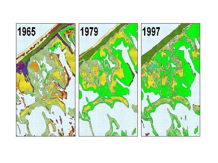
Discussion: Spatial Maps (10 minutes) In small groups, discuss the following questions. 1. Using the maps provided, what can you tell about changes that may have occurred in this wetland system between 1965 and 1997?
Discussion: Spatial Maps (10 minutes) 2. Give examples of other spatial data layers that could be overlaid and integrated for further analysis. 3. Describe how these time series maps can be used and integrated into an SOE report, and the information they provide.