Module 17 Groundwater Global Distribution of Water The

Module 17 Groundwater

Global Distribution of Water

The Hydrologic Cycle

Groundwater-Related Terms to Remember • Aquifer: a body of rock or soil that stores and easily transmits a significant quantity of groundwater – A confined aquifer is overlain by an aquitard – An unconfined aquifer is overlain by the water table • Aquitard: an impermeable bed that hinders movement of groundwater • Artesian well: a well in which the groundwater rises to a level higher than where it was first encountered • Cone of depression: a cone-shaped depression in the water table surrounding a well from which water is pumped faster than it can move through the aquifer

Groundwater-Related Terms to Remember • Drawdown: is the difference in elevation between the undisturbed water table and the bottom of a cone of depression • Geyser: a type of hydrothermal spring that intermittently erupts jets of hot water and steam • Groundwater: water in the zone of saturation • Hard water: does not lather readily with soap, due to high concentration(s) of Ca 2+, Mg 2+, Fe 2+, and/or Mn 2+ • Karst topography: formed in limestone bedrock in response to dissolution of the limestone by acidic water – Characterized by the presence of caves, sinkholes, disappearing streams, solution valleys, etc.

Groundwater-Related Terms to Remember • Perched water table: unconfined groundwater separated from the underlying main body of groundwater by an aquitard and a zone of aeration • Percolation: slow movement of water through small openings within a porous material • Permeability: a measure of the ability of a material to transmit groundwater. Dependent upon – How many conduits are present – How big the conduits are – How straight the conduits are • Pore space: any open space within a body of sediment or rock

Groundwater-Related Terms to Remember • Porosity: the percentage of a material occupied by pore spaces • Primary porosity: the spaces between grains composing the rock • Secondary porosity: cracks and caves produced by jointing, faulting, and dissolution of the bedrock • Sinkhole: a depression formed by collapse of the roof of a cave • Spring: a flow of groundwater naturally emerging at the Earth’s surface

Groundwater-Related Terms to Remember • Stalactite: an icicle-like structure attached to the ceiling of a cave • Stalagmite: a conical-shaped structure attached to the floor of a cave • Zone of aeration: the unsaturated region above the water table, the region where the pore spaces are filled partially with air and partially with water • Water table: the top of the zone of saturation • Zone of saturation: the region below the water table, the region where the pore spaces are completely filled with groundwater

Features Associated with Subsurface Water Perched water table Water table Zone of aeration: Pore spaces contain air and water Zone of saturation: Pore spaces are filled with water

Perched Water Tables (Plummer, Mc. Geary, and Carlson, 2003, Physical Geology, 9 th ed. ) Mudstone Sandstone

Surface Exposure of the Water Table The surface of any sea, lake, pond, stream, or spring is the water table Water table
 is always perpendicular to the")
A Gaining Stream Note that groundwater flow (blue lines) is always perpendicular to the equipotential lines (black lines) Water table

Movement of Groundwater During wet weather the water table rises, is recharged During drought the water table falls

Movement of Groundwater Note that the topography of the water table usually mimics the topography of the land

Gaining and Losing Streams A gaining stream: During rainy seasons streams gain water from the saturated zone A losing stream: During droughts streams lose water to the saturated zone In arid regions: The topography of the water table does not mimic the topography of the land

Cone of Depression Produced by a Pumping Well A cone of depression: forms in vicinity of a pumped well because the groundwater is pumped out faster than it can move through the ground Drawdown: is the difference in elevation between the undusturbed water table and the bottom of the cone of depression

Porosity and Permeability of Sediments and Rocks

Primary Porosity: the percent of a material occupied by pore spaces Primary porosity: the spaces between the grains composing the rock

Secondary Porosity: the percent of a material occupied by pore spaces Secondary porosity: the cracks and caves produced by jointing, faulting, and dissolution of the bedrock

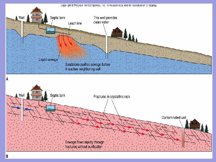
Effect of Porosity and Permeability on Wells: Mudstone versus Sandstone High porosity, high permeability High porosity, low permeability

Effect of Porosity and Permeability on Wells: Fractured versus Un-fractured Bedrock

Unconfined and Confined Aquifers Unconfined aquifer Confined aquifer

Artesian Systems Artesian systems are systems in which groundwater rises higher than the elevation at which it was first encountered

Flowing Artesian Well

Karst Topography • Is named after where it was first recognized, in Karst Yugoslovia • Karst topography is formed by dissolution of limestone bedrock by acidic groundwater • The features of karst topography are: – Caves – Stalactites and stalagmites – Sinkholes – Dissolution valleys – Disappearing streams – Reappearing streams

Features Associated with Karst Topography

Features Associated with Karst Topography

Fig. 11. 21 stalactite stalagmite

Sinkholes
 COASTAL")
Sinkhole Formed in Santee Limestone (the Atlantic Coastal Plain, Santee State Park, SC) COASTAL PLAIN, SINKHOLE, SANTEE STATE PARK

Water from recent heavy rains flowing into a sinkhole in a lake bed at Santee State Park. All the water in the lake rapidly drained into the cave when this sinkhole formed in 1999.

Springs • A spring is a flow of groundwater naturally emerging at Earth’s surface • Springs are formed where: – a prominent joint system intersects the ground surface – a perched water table intersects the ground surface – a cave system intersects the ground surface – a fault intersects the ground surface

Springs

Geysers and Travertine Terraces • Geysers occur in hydrothermal areas where groundwater is heated by hot rock and erupted at the ground surface • Travertine terraces form at the ground surface where calcium carbonate is precipitated from hydrothermal water percolating through limestone bedrock

Geysers

Old Faithful, Yellowstone National Park, WY

Travertine Terraces, Mammoth Hot Springs, Yellowstone

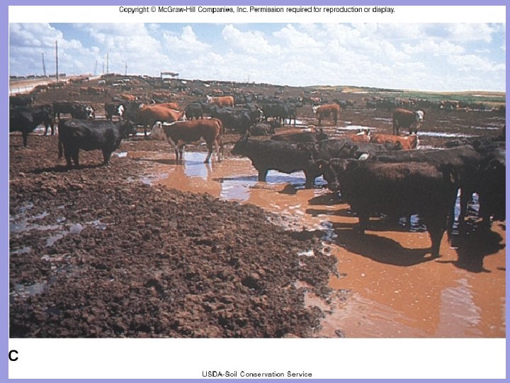
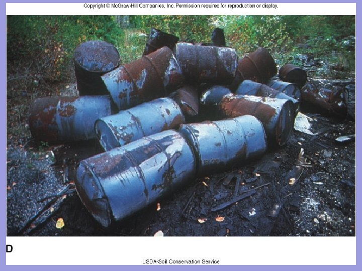
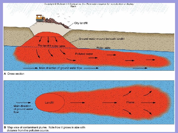
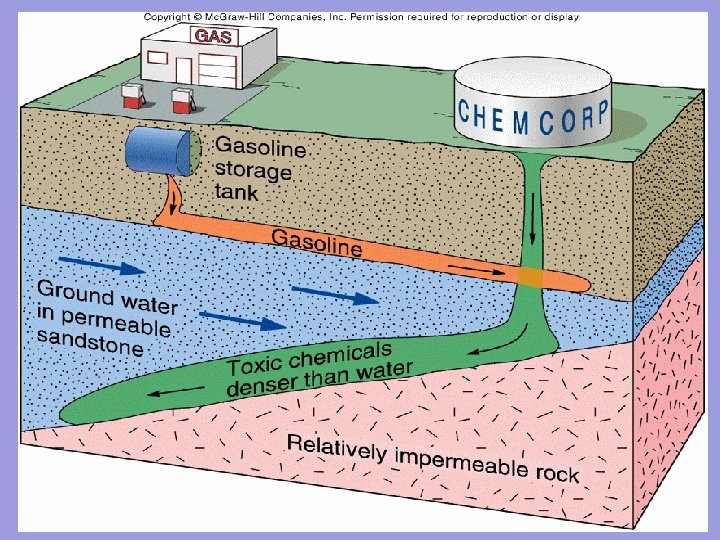
Problems Affecting the Water Table and Groundwater Subsidence

Problems Affecting the Water Table and Groundwater Salt Water Intrusion Contamination
- Slides: 44