MODIS BRDFALBEDO PRODUCTS Crystal B SCHAAF Alan H

MODIS BRDF/ALBEDO PRODUCTS Crystal B. SCHAAF, Alan H. STRAHLER, Feng GAO, Wolfgang LUCHT, Yufang JIN, Xiaowen LI, Xiaoyang ZHANG, Elena TSVETSINSKAYA, Jan-Peter MULLER, Michael BARNSLEY, Philip LEWIS, Gareth ROBERTS, Christopher DOLL, Shunlin LIANG, David ROY, and Jeffrey PRIVETTE Center for Remote Sensing, Boston University, 725 Commonwealth Avenue, Boston, MA 02215, USA Tel. +617 -358 -0503, Fax +617 -353 -3200, e-mail: schaaf@bu. edu. Potsdam-Institut für Klimafolgenforschung, Postfach 601203, D-14412 Potsdam, Germany Research Center for Remote Sensing, Beijing Normal University, Beijing, China Depart. of Geomatic Engineering, University College London, Gower St. , London, WCIE 6 BT, UK Department of Geography, University of Wales Swansea, Singleton Park, Swansea, SA 2 8 PP, UK Department of Geography, University of Maryland, College Park, MD 20742, USA NASA/Goddard Space Flight Center, Code 923, Greenbelt, MD 20771, USA

MODIS BRDF/ALBEDO PRODUCT The MODIS BRDF/Albedo Product uses multidate, multispectral, cloudcleared, atmospherically-corrected MODIS surface reflectances and a BRDF model to provide global measures of albedo, nadir surface reflectance and surface anisotropy every 16 days at a 1 km gridded spatial resolution. 1. BRDF model parameters describe the anisotropy of the surface. Albedo and surface reflectance measures can be computed at any desired view and illumination geometry. 2. Bihemispherical albedo (white-sky) and directional hemispherical albedo (black-sky) at local solar noon are computed. Actual albedos can be estimated by interpolating the diffuse and direct beam albedos as a function of diffuse skylight. 3. Nadir BRDF-adjusted Reflectances (NBAR) at mean overpass. Surface reflectances corrected to a common nadir viewing geometry.

MODIS BRDF/ALBEDO PRODUCT The primary BRDF retrieval algorithm is bolstered by a robust back-up algorithm. 1. The full model inversion is used when sufficient high quality MODIS observations are available to sample the BRDF. 2. The lower quality magnitude inversion couples a priori knowledge of the surface anisotropy with any MODIS observations that are available. 3. Extensive Quality Assurance Flags are supplied with the product indicating both the quality of the product and the processing method used.

MOD 43 B MODIS BRDF/ALBEDO PRODUCT Products at 1 km MOD 43 B 1: MODIS/Terra BRDF/Albedo Model-1 16 -Day L 3 Global 1 km ISIN Grid MOD 43 B 3: MODIS/Terra Albedo 16 -Day L 3 Global 1 km ISIN Grid MOD 43 B 4: MODIS/Terra Nadir BRDF-Adjusted Reflectance 16 -Day L 3 Global 1 km ISIN Grid (NBAR) Products at 5 km MOD 43 B 1 C: MODIS/Terra BRDF/Albedo Model-1 16 -Day L 3 Global 5 km ISIN Grid MOD 43 B 3 C: MODIS/Terra Albedo 16 -Day L 3 Global 5 km ISIN Grid MOD 43 B 4 C: MODIS/Terra Nadir BRDF-Adjusted Reflectance 16 -Day L 3 Global 5 km ISIN Grid Products at ¼ degree MOD 43 C 1: MODIS/Terra Albedo 16 -Day L 3 Global 0. 25 Deg CMG MOD 43 C 2: MODIS/Terra BRDF/Albedo Parameters 16 -Day L 3 Global 0. 25 Deg CMG Gao et al. , Global Coarse Resolution Albedo from MODIS BRDF/Albedo Product for Climate Models (CMG), submitted Geophys. Res. Let. , 2002.
 6 - 21 March, 2001")
CMG Broadband White-Sky Albedo (0. 3 -5. 0 mm) 6 - 21 March, 2001 No Data 0. 0 0. 2 0. 4
 9 - 24 May, 2001")
CMG Broadband White-Sky Albedo (0. 3 -5. 0 mm) 9 - 24 May, 2001 No Data 0. 0 0. 2 0. 4
 14 - 29 September, 2001")
CMG Broadband White-Sky Albedo (0. 3 -5. 0 mm) 14 - 29 September, 2001 No Data 0. 0 0. 2 0. 4
 is")
MOD 43 B MODIS BRDF/ALBEDO PRODUCT AQUA code (actually AQUA + TERRA code) is delivered and baselined: Gridded surface reflectances from both the TERRA MODIS sensor and the AQUA MODIS sensor are used to retrieve the 16 -day BRDF parameters and compute albedos at local solar noon. NBARs at both the TERRA overpass time and the AQUA overpass time are computed. The TERRA only version and the TERRA+AQUA version will run in parallel during the shakeout period. MODIS + MISR code has also been successfully proto-typed on several regional case studies.

STATUS of the MOD 43 B MODIS BRDF/ALBEDO PRODUCT The MOD 43 B 1 km products: Operational production began in April 2000. Beta Products were released in July 2000. Provisional Products were released in November 2000. The MOD 43 C CMG ¼ degree Products are just entering production (July 2001 onward). Currently awaiting evaluation of the reprocessed data for final characterization of the product variability and for final comparisons with field data before assigning product quality assessments and releasing the data as Validated Products.
 31 October - 15 November, 2000 No Data")
North American Nadir BRDF-Adjusted Reflectance (NBAR) 31 October - 15 November, 2000 No Data NIR (0. 1 -0. 4) Red (0. 0 -0. 16) Green (0. 0 -0. 18)
 31 October - 15 November, 2000 Reprocessed No")
North American Nadir BRDF-Adjusted Reflectance (NBAR) 31 October - 15 November, 2000 Reprocessed No Data NIR (0. 1 -0. 4) Red (0. 0 -0. 16) Green (0. 0 -0. 18)

MOD 43 B MODIS BRDF/ALBEDO PRODUCT EVALUATION The Team Evaluation is focused on: MOD 43 B Quality Assurance Flags. Variability of products by cover type. Temporal stability and consistency of products. Predictive capability of BRDF parameters.

NBAR from Land Cover Training Sites in the Southern US Schaaf et al. , First Operational BRDF, Albedo and Nadir Reflectance Product from MODIS, in press, Remote Sensing Environ. , 2002

Snow versus Non-snow Albedos 40 -50°N Nov 00 -Jan 01 Jin et al. , How does Snow Impact the Albedo of Vegetated Land Surfaces as Analyzed with MODIS Data? , in press, Geophys. Res. Let. , 2002

Using BRDF Parameters to Predict Future Surface Reflectances Observed 1 km Surface Reflectances 20 November, 2000 (Day 325) Predicted 1 km Surface Reflectances for 20 November, 2000, using BRDF Parameters from 31 Oct - 15 Nov, 2000 NIR (0. 1 -0. 35) Red (0 -0. 12) Green (0 -0. 12)

0. 0 P r e d i c t e d 0. 1 Full Inversions (Red) Observed 0. 12 r=0. 823 0. 10 0. 35 r=0. 750 0. 12 2 P r e d i c t e d 0. 0 Magnitude Inversions (Red) 0. 0 Observed 0. 12 Full Inversions (NIR) Observed 0. 35 0. 10 Magnitude Inversions (NIR) 0. 10 Observed 0. 35 r=0. 794 r=0. 893 0. 35
")
MOD 43 B MODIS BRDF/ALBEDO PRODUCT VALIDATION BARC Field Campaigns -- S. Liang (UMD) SAVE/SAFARI Field Campaigns -- J. Privette (GSFC) Barton Bendish Field Campaigns -- M. Barnsley (UWales, Swansea) China Field Campaigns -- X. Li (BU & Beijing Normal U. ) SURFRAD Comparison -- Y. Jin (BU)

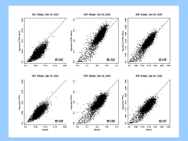
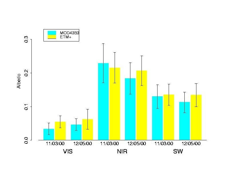
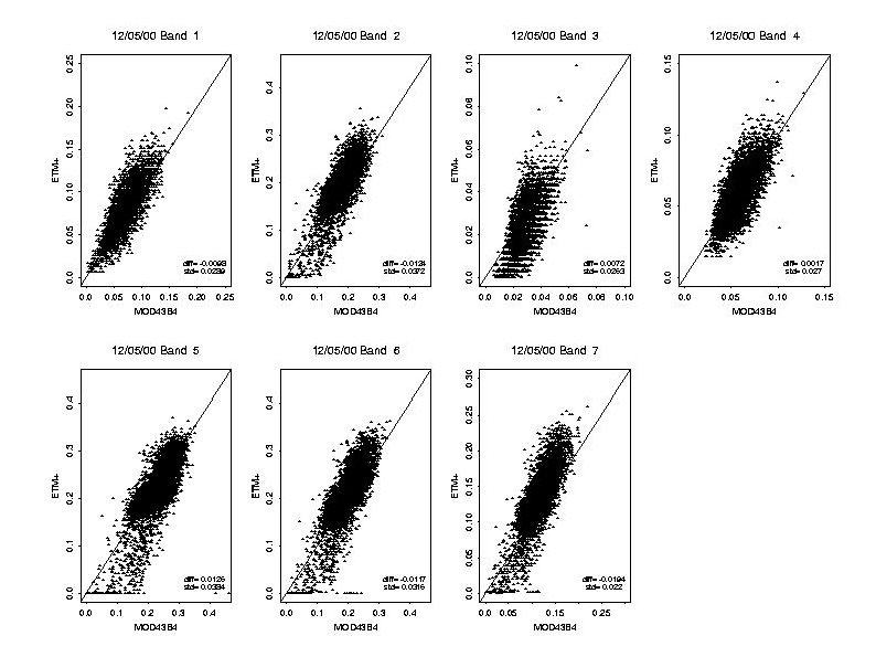
BARC Validation Efforts Albedometer measurements from a 10 m tower and sun photometer measurements are routinely collected at the USDA Agricultural Research Service Beltsville Agricultural Research Center (BARC) in Beltsville, Maryland, USA. A number of ground campaigns (ASD, LAI, leaf optics) have been completed.

BARC Validation Efforts ETM+ imagery is used to scale Ground and Tower measurements up to MODIS spatial resolutions. Initial validation results from November and December 2000 show that these products are quite accurate with less than a 5% error. Liang et al. , Validating MODIS Land Surface Reflectance and Albedo Products: Methods and Preliminary Results, in press, Remote Sensing Environ. , 2002.
 Tower data are being collected at the Mongu,")
South African Validation of EOS (SAVE) Tower data are being collected at the Mongu, Zambia woodland site and the Skukuza, South Africa savanna site. Ground measurements were collected during the SAFARI IFCs. Comparisons with MODIS Surface Reflectance and Albedo Products are currently underway.
")
South African Validation of EOS (SAVE)
 Diurnal and Seasonal Variability Relative Error NIR Albedo")
South African Validation of EOS (SAVE) Diurnal and Seasonal Variability Relative Error NIR Albedo from the Mongu Tower Mean Albedo Quality Control Time Series: March 2000 to present

Barton Bendish Field Validation Efforts LAI and albedo data were collected at the agricultural site at Barton Bendish, East Anglia, UK during the 2000 and 2001 growing seasons. ETM+ data are used to scale up to coarser spatial resolutions.

Barton Bendish Field Validation Efforts BRDF Model Parameters Composite -- derived from SPOT-VGT data of the UK. Reprocessed MODIS data from summer 2001 has just become available for validation effort.

Barton Bendish Field Validation Efforts Additional hyperspectral imagery of Barton Bendish and other EOS core validation sites is being obtained from the Compact High Resolution Imaging Spectrometer (CHRIS) launched on the Project for On Board Autonomy (PROBA) in Oct 2001.
 Institute of Remote Sensing Application")
Field Campaign for Quantitative Remote Sensing in Beijing (2001) Institute of Remote Sensing Application (Chinese Academy of Sciences) and Beijing Normal University. Agricultural field sites in Shunyi, Yucheng, and Luncheng, China. Extensive ground measurements, some airborne data and various satellite imagery have been collected since October, 2000. Shunyi Site Beijin g Tianjing Shi. Jiazhu ang Luan Cheng Site Yucheng Site Ji Nan Zhen. Zh ou

Field Validation Efforts in China
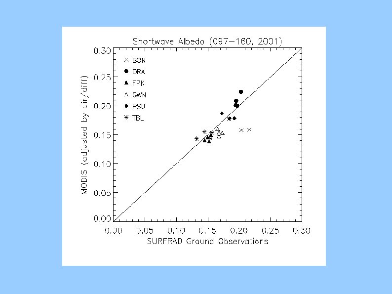
 Six instrumented sites continuously measuring solar radiation (including PAR,")
Surface Radiation Budget Network (SURFRAD) Six instrumented sites continuously measuring solar radiation (including PAR, direct and diffuse). Data packaged and distributed as half hour values by the CERES/ARM Validation Experiment (CAVE).

MOD 43 B MODIS BRDF/Albedo Product Summary Initial evaluations indicate that the MOD 43 B algorithms have performed well throughout 2000 and 2001. Data (particularly the reprocessed data) appear temporally stable and consistent. Initial validations and comparisons are very encouraging with errors of less than 10%. Team is awaiting completion of the reprocessed data to have a relatively consistent annual cycle before finalizing validation efforts and posting error and variability estimates. We expect to upgrade reprocessed data to “Validated” status during the first half of 2002.

MOD 43 B MODIS BRDF/ALBEDO PRODUCT Provisional and Reprocessed Products (starting with the 16 day period beginning on Day 305 -- 31 October 2000) are available from EDC at http: //edcdaac. usgs. gov/main. html Users Guide is available at http: //geography. bu. edu/brdf/userguide/index. html Browse images (based on 5 km resolution products) can be viewed at http: //modland. nascom. nasa. gov/browse/ Global CMG Products on a ¼ degree resolution Geographical Grid will be available from EDC in the new year.
- Slides: 34