MODERN SYSTEMS OF THE OPERATIONAL WEATHER FORECAST WITH


 V. Bjerknes")


, (France) ),")


")


 Model-based system for nowcasting and very short range forecasting Goals: Prediction")


")


- Slides: 46
MODERN SYSTEMS OF THE OPERATIONAL WEATHER FORECAST WITH NONHYDROSTATIC MODELS OF THE ATMOSPHERE Gdaly Rivin, Hydrometcentre of Russia COSMO General meeting 14 -20 September 2008, Krakow, Poland
The system of equations (conservation laws applied to individual parcels of air) V. Bjerknes (1904) pointed out for the first time that there is a complete set of 7 equations with 7 unknowns that governs the evolution of the atmosphere: • conservation of the 3 -dimensional momentum (equations of motion), • conservation of dry air mass (continuity equation) • • the equation of state for perfect gases conservation of energy (first law of thermodynamics) • equations for the conservation of moisture in all its phases They include in their solution fast gravity and sound waves, and therefore in their space and time discretization they require the use of smaller time steps, or alternative techniques that slow them down.
From the 3 -dimensional equations of motion we have: For models with a horizontal grid size larger than 10 km, it is customary to replace the vertical component of the equation of motion with its hydrostatic approximation, in which the vertical acceleration is neglected compared with gravitational acceleration (buoyancy): If a horizontal grid size less than 10 km, it is necessary to use the nonhydrostatic approximation
FEATURES OF COMPUTATIONAL TECHNOLOGIES IN ATMOSPHERIC SCIENCES Coordinate systems: z, p, sigma. F, sigma. L, eta, hybrid Models of atmosphere: Steps: Methods: global 25 -60 km, local 2 -12 km; spectral, finite-difference schemes, splitting, RK 3, semi-Lagrangian scheme (2 3), ensembles, grids, MPI, OMP Data assimilation: 3(4)D-Var, Kalman filter Reanalyses NCEP/NCAR USA Reanalyses-2 ECMWF ERA-15 ERA-40 1948 -. . . ; 1979 -1993 1957 -2001 (T 62 L 28, 210 km) (ETA RR, 32 km, 45 layers) (TL 106 L 31, 150 km) (TL 159 L 60, 120 km, 3 D-Var)
NCEP Forecast Systems and Mission Applications • Forecast Systems 1. 2. 3. 4. 5. 6. 7. 8. 9. 10. 11. • Global Forecast System (GFS) & GDAS North American Model (NAM) & RDAS Rapid Update Cycle (RUC) Global Ensemble System (GEN) Short-Range Ensemble Forecast System (SREF) Air Quality Forecast System Hurricane System (HUR) Real Time Ocean Forecast System (RTOFS) Global and Regional Wave System (WAV) Ice Drift System (ICE) Climate Forecast System (CFS) Mission Applications 1. 2. 3. 4. Weather and Water – all except CFS Surface transportation – RUC, RTOFS, ICE and WAV Climate – GFS and CFS Ecosystem - none
ECMWF, IFS TL 799 L 91; 25 km, TL 399 L 62; TL 255 L 62; 10 UK, UM FD, L 50; 40 km, Germany GME FD, L 40; 40(20) km 7 Russia, SM T 85 L 31, 150(75)km, 10 USA, GFS France, ARPEGE IFS (ECMWF) Japan (GSM) T 382 L 64; T 190 L 64; 6 51; 50 km, 00 -10 51; 60 km, 11 -15 NEC SX 6, 34 nodes; NEC SX 8 16 nodes, 4 (2011: 1000 Tf) L 38; 24; 90 км, 15 52 km, 01 -07 T 126 L 28, 104 km, 07 -16 IBM p 690, 2 x 68 nodes, 20 (2015 : IBM 200 Tf ) ‑‑‑‑‑‑‑ IBM p 690; x 52 узлов, 2 x 3. 1 ‑‑‑‑‑‑‑ Itanium 4 x 4; 0. 1 2008 : ALTIX 4, 11, 16 45; 160 km, 16 IBM p 655 7. 8 TL 358 L 41; 23 -133 km , 0 -4 Fujitsu VPP 5000, TL 358 L 41, 11; 23 -133 km; 2. 5 TL 511 L 60; 40 km , 4 -7 31 processors, 1. 2 TL 319 L 40; 56 km(25), 9 T 159 L 40; 51; 112 km, 9 HITACHI SR 11000/K 1, 2× 80 nodes × 16 processors, 21
ECMWF operational analysis and forecasting system The comprehensive earth-system model developed at ECMWF forms the basis for all the data assimilation and forecasting activities. All the main applications required are available through one integrated computer software system (a set of computer programs written in Fortran) called the Integrated Forecast System or IFS • Numerical scheme: �TL 799 L 91 (799 waves around a great circle on the globe, 91 levels 0 -80 km) �semi-Lagrangian formulation • Time step: � 12 minutes • Prognostic variables: �wind, temperature, humidity, cloud fraction and water/ice content, pressure at surface grid-points, ozone • Grid: �Gaussian grid for physical processes, ~25 km, 76, 757, 590 grid points EPS model grid (T 399)
Horst Boettger, ECMWF
q the Penn State/NCAR Mesoscale Model (e. g. , Dudhia, 1 q the CAPS Advanced Regional prediction System (Xue q NCEP's Regional Spectral Model (Juang et al, 1997), q the Mesoscale Compressible Community (MCC) mode (Laprise et al, 1997), q the CSU RAMS Tripoli and Cotton (1980), q the US Navy COAMPS (Hodur, 1997).
EUROPEAN LANDSCAPE • • ALADIN (Aire Limitée Adaptation dynamique Développement Inter. National), (France) ), COSMO (The Consortium for Small-scale Modeling), (Germany)), HIRLAM (HIgh Resolution Limited Area Model), (Scandinavian), UK (Unified Model). • USA (WRF – Weather Research and Forecasting – for operational forecasting and atmospheric research needs) • Japan (MSM – Mesoscale Model )
Contributing models Verification Methods Workshop 2007
Centre DWD: 2007, January 2008 2009 665 x 657; L 40; 7 421 x 461; L 50; 2. 8 the same Japan: 721 x 577; L 50; 5 the same France: 300 x 300; L 60; 9. 5 UK: 600 x 360; L 70; 12 288 x 360; L 60; 4 USA: 606 x 1067; L 60; 12 360 x 809; L 35; 5 HIRLAM: 500 x 500; L 60; 2. 5 the same 726 x 1287; L 60; 12 720 x 1011; L 50; 4 500 x 500; L 90; 2. 5 600 x 360; L 90; 12 768 x 960; L 80; 1. 5 the same
USA, W R F (ARW / NMM)
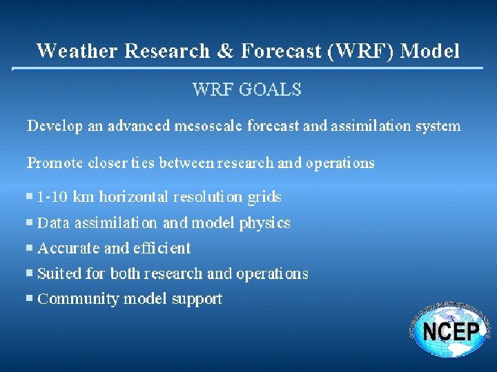
WRF: Weather Research and Forecast An Overview WRF is… a multi-agency partnership to create and sustain: A next-generation mesoscale NWP modeling system for use by both research and operations; A common modeling infrastructure that facilitates collaboration and scientific interoperability, is scaleable & portable and accelerates the transfer of new science from research into operations. http: //www. wrf-model. org/index. php 17 May 2007 Geoff Di. Mego, NCEP, EMC
UK
Unified Model Operational Configurations Global 40 km N 320 L 50 Old UK 12 km, withdrawn 26/09/06 640 x 481 x 50 63 km top 150 million numbers North Atlantic & European 12 km 720 x 432 x 38 38 km top 120 million numbers 4 D-Var, 6 -hrly New UK 4 km 288 x 320 x 38 38 km top 35 million numbers, 36 -h fc. 3 D-Var, 3 -hrly + MOPS cloud + LHN
http: //www. metoffice. com/research/nwp/numerical/unified_model/new_dynamics. h The Met Office Global Numerical Weather Prediction m was implemented on 7 th August 2002. The package of changes was under trial for over a year and is known as "N This document details some of the key changes that are part of the New Dy · Non-hydrostatic model with height as the vertical co-ordinate. · Charney-Philips grid-staggering in the vertical, · Arakawa C-grid staggering in the horizontal, · Two time-level, semi-Lagrangian advection and semi-implicit time stepp · Edwards-Slingo radiation scheme with non-spherical ice spectral files · Large-scale precipitation includes prognostic ice microphysics. · Vertical gradient area large-scale cloud scheme. · Convection with convective available potential energy (CAPE) closure, momentum transports and convective anvils. · A boundary-layer scheme which is non-local in unstable regimes. · Gravity-wave drag scheme which includes flow blocking. · GLOBE orography dataset. · The MOSES (Met Office Surface Exchange Scheme) surface hydrology and soil model scheme. ·Predictor-corrector technique with no extraction of basic state p ·Three-dimensional Helmholtz-type equation solved using GCR te
FRANCE
The ARPEGE global model Computational grid Spectral TL 358 L 41 (grid 720 x 360 x 41) Variable resolution C 2. 4 with focus over France (dx=23 km on France, 133 km on New Zealand) F. Bouttier, Météo-France
ARPEGE/ALADIN coupling: Arpege and Aladin models global 4 -day forecasts, 4 times a day ALADIN regional 2 -day forecasts, 4 times a day, higher resolution F. Bouttier, Météo-France
HIRLAM
2005 -2006 Operational Implementation Coarse mesh domains
Germany, DWD
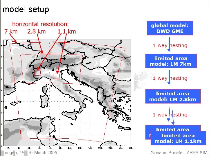
COSMO-EU: x = 7 km 665*657 * 40 grid points t = 40 sec. Forecast: 00, 12, 18 UTC on 78 h. COSMO-DE: x = 2. 8 km 421*461 * 50 grid points t = 30 sec. Forecast: 0, 3, 6, 9, 12, 15, 18, 21 UTC on 18 h. GME: x = 40 km 368642 * 40 grid points t = 133 sec. Forecast on 7 days
ICON with a double nest covering Europe and Central Europe Detlev Majewvski, DWD
COSMO-DE (LMK: LM-Kürzestfrist) Model-based system for nowcasting and very short range forecasting Goals: Prediction of severe weather on the mesoscale. Explicit simulation of deep convection. Method: 18 -h predictions of COSMO-DE initialised every three hours, mesh size < 3 km Usage of new observations: SYNOP: Every 60 min, GPS: Every 30 min, Reflectivity: Every 15 min, Aircraft data. METAR: Every 30 min, VAD winds: Every 15 min, Wind profiler: Every 10 min,
Ensemble ? +18 h +15 h +12 h +9 h +6 h +3 h 00 03 06 COSMO-DE: 09 12 15 18 21 00 18 -h forecast every three hours (UTC)
Validation of Mesoscale Wind Forecasts for Ireland Paul Nolan, Peter Lynch Meteorology & Climate Centre University College Dublin
Wind Validation: Rosslare (2005 - 2006)
FIM http: //fim. noaa. gov Global Spectral models have gained almost universal acceptance in the last several decades. However, drawbacks of high-resolution spectral models in terms of operation counts and communication overheads on massive parallel processors have led, in recent years, to the development of new types of grid-point global models discretized on geodesic grids [see, e. g. , Tomita et al. (2001)]. Tomita, H. , M. Tsugawa, M. Satoh, and K. Goto, 2001: Shallow water model on a modified icosahedral geodesic grid by using spring dynamics. J. Comput. Phys. , 174, 579– 613. Among those, the icosahedral grid is attractive because it achieves quasi-uniform coverage of the globe with minimal regional variations in the shape of grid cells. If configured as a grid consisting of a large number of hexagonal cells (with 12 embedded pentagons), the icosahedral grid is particularly suitable for finite-volume numerics in which conventional finite difference operators are replaced by numerically approximated line integrals along cell boundaries. The German Weather Service is currently using an icosahedralhexagonal model for operational global weather prediction (Majewski et al. 2002). Majewski, D. Lier. Mann, P. Prohl, B. Ritter, M. Buchhold, T. Hanisch, G. Paul, and W. Wergen, 2002: The operational global icosahedral-hexagonal gridpoint model GME: Description and high-resolution tests. Mon. Wea. Rev. , 130, 319– 338. A Japanese group (Tomita et al. 2004) has developed a nonhydrostatic general circulation model (GCM) formulated on an icosahedralhexagonal. Tomita, H. , M. Satoh, and K. Goto, 2004: A new dynamical framework of global nonhydrostatic model using the icosahedral grid. Fluid Dyn. Res. , 34, 357– 400.
RUSSIA SOCHI 2014 ?
4. Future Development of the NWP-System 2008 SGI Altix 4700 832 Intel ® Itanium® 9140 Dual SGI ICE 8200 354 Intel ® Xeon® 5400 Quad G-Scale S 4700 52 Intel ® Itanium® 9140 Dual 11 Tflops, 16 Тflops 0. 7 Тflops Moscow SGI Altix SGI ICE Novosibirsk G-Scale Chabarovsk G-Scale Hydrometeorological centre of Russian Federation
COSMO-Ru operational running the HMC of Russia uses: the 1 node (2 processors Xeon 5345, 2. 33 GHz, with 4 cores each and 32 Gb operative memory on node, 64 -bit, OS - RHEL 5 (Red Hat Enterprise Linux 5), Intel C++ 10. 0. 26, Intel Fortran 10. 0. 26, Intel MPI 3. 0) is used. The synopticforecasters begin to use the model output as additional forecasting information and to test it. The first information about the forecast skill of some atmospheric variables (T 2 m, pressure, precipitation, and cloudiness) is obtained; 2 times per day (00 and 12 UTC) the HMC of Russia receives by Ftp GME data from DWD and produces the forecasts for 78 h for the European part of Russia with h=14 km, dt=80 s (ie=168, je=300). Time of the run with 8 cores (1 x 8 topology) is 3 h 35 min. The specialists of HMC of Russia had the possibility to do several runs on Altix Itnium with 256 cores, the effective variant for this grid is for cartesian topology is 8 x 32=256, variants with 16 x 16=256 or 4 x 64=64 are worse. In this case (8 x 32) the run time for 78 h forecast was 311 s. The special data bases are modified and special system of the visualization are prepared in the HMC of Russia. Psea, T 2 m; 2008091000; Forecast +60 h
Orography h = 2. 8 km Mask of the land/sea
Время счета в секундах прогноза на 1 час по модели COSMO-RU Вариант Xeon 5345 2 proc. Quad 1 х1 1 х2 1 х4 1 х8 1 х16 2 х2 2 х4 2 х8 521 272 202 167 170 206 168 Ускорение 521 : 167 = 3. 12 Вариант 12 x 15=180 10 х25=250 16 х16=256 08 х32=256 04 х64=256 32 x 08=256 Ускорение Itanium 2 proc. Dual C включенным SMT 530 328 325 228 221 652 244 219 Itanium 2 proc. Dual C отключенным SMT 542 335 250 228 200 255 212 192 530 : 219 = 2. 42 542 : 192 = 2. 75 Altix Itanium 256 473 292 151 103 53 154 108 52 473 : 52 = 9. 09 Время счета в секундах прогноза на 78 час. по модели COSMO-RU Вычисления на Altix Itanium (Алиса) до 256 ядер с применением Intel компиляторов C, F 90 v 10. 3 и MPI 3. 1 c отключенным SMT Время прогноза на 78 часов Среднее время прогноза на 1 час 373. 35 4. 8 313. 95 4. 0 336. 61 4. 3 311. 47 4. 0 345. 47 4. 4 419. 90 5. 4 = 118. 25 (раз)