Modeling Tsunami Inundation and Assessing Tsunami Hazards for


")
")
")
")
")
")
")


![=> Model simulations recover measured runups with good accuracy [Ioualalen et al (2007)]](https://slidetodoc.com/presentation_image/ecfa647d5384d09f84b4a9a3d7814afc/image-21.jpg "=> Model simulations recover measured runups with good accuracy [Ioualalen et al (2007)]")


.")

 Name NTHMP")
 Name Task 1.")
 Name NTHMP")
 Name NTHMP")
- Slides: 35
Modeling Tsunami Inundation and Assessing Tsunami Hazards for the U. S. East Coast a proposal to the National Tsunami Hazard Mitigation Program w Participants w Personnel University of Delaware UD: James Kirby Fengyan Shi John Callahan (primary contractor) University of Rhode Island (subcontractor to UD) URI: Stephan Grilli Chris Baxter Stephan Abadie
Project Goals w Assess tsunami hazard from a range of event types with possible impact on the U. S. East Coast. w Identify most likely candidate sites for mapping and modeling. w Perform local inundation studies and begin construction of inundation and evacuation maps for targeted sites.
Approach w Project is divided into five tasks, all of which fall within the scope of Section 1: Mapping and Modeling, and all of which support the NTHMP Strategic Metric 1: “Successful execution of NTHMP tsunami mapping, modeling, mitigation, planning and education efforts”
Task 1. 1: Review of Existing Literature on Tsunami Hazard Assessment and Tsunamigenic Sources affecting the U. S. East Coast w Lack of historical tsunami records w Uncertainty regarding the magnitude and return periods of potential large-scale transoceanic events (e. g. , large co-seismic source from the Azores-Gibraltar convergence zone or Puerto Rico; volcanic island flank collapse, e. g. , Cumbre Vieja) w Most significant tsunami hazard in this region may arise from “local” Submarine Mass Failures (SMF) triggered on the continental slope by moderate seismic activity (e. g. , the 1929 Grand Bank landslide tsunami)
Task 1. 1: Review of Existing Literature on Tsunami Hazard Assessment and Tsunamigenic Sources affecting the U. S. East Coast w assess tsunami hazard from the above and other relevant tsunami sources recently studied in the literature (ten Brink et al. , 2008; MG special issue, 2009) => assess tsunami hazard from the above and other relevant tsunami sources recently studied in the literature [ten Brink et al. (2008); Marine Geol. special issue (2009)]
Task 1. 2: Probabilistic analysis of coastal hazards associated with submarine mass failures (SMF) w SMF tsunami hazard will be obtained from a probability analysis, using a Monte Carlo (MC) model, which was developed and applied to the region from New Jersey to Maine (Grilli et al, 2009). w This MC model will be extended to coastal regions down to the Florida border: hs [Selected shelf transect geometry]
Task 1. 2: Probabilistic analysis of coastal hazards associated with submarine mass failures (SMF) w This MC model will be extended to coastal regions down to the Florida border: w => Stochastic selection of w sediment properties, SMF w type, size and location/depth w => Selection of seismic w ground acceleration based w on location and return period => Stochastic slope stability analysis (transl. or rotational) => Tsunami generation based on SMF parameters from earlier numerical modeling of SMF tsunami (Grilli et al, 2005, 2009)
Task 1. 2: Probabilistic analysis of coastal hazards associated with submarine mass failures (SMF) w This MC model will be extended to coastal regions down to the Florida border. [Global seismicity] [Local seismicity]
Task 1. 2: Probabilistic analysis of coastal hazards associated with submarine mass failures (SMF) w This MC model will be extended to coastal regions down to the Florida border:
Task 1. 2: Probabilistic analysis of coastal hazards associated with submarine mass failures (SMF) w This MC model will be extended to coastal regions down to the Florida border: [Tsunami propagation] [Ex. : Runup: 100 y (---); 500 y (- -)]
Task 1. 2: Probabilistic analysis of coastal hazards associated with submarine mass failures (SMF) w This MC model will be extended to coastal regions down to the Florida border: => The extended MC model will be run from Florida to Maine => Based on MC results, parameters will be selected for a large number of realistic SMF sources, representing specific SMF tsunami hazard in the region (e. g. , 100, 500 years). => The selected SMF tsunami sources will be used to perform actual simulations of tsunami generation, propagation, and coastal impact (-> inundation and runup in nested grids). => Other relevant SMF sources from historical cases known in the region (e. g. , 1929 Grand Bank, Piper et al. , 1999; Currituck slide, Geist et al. , 2009, Locat et al. , 2009) will also be designed and simulations will be performed.
Task 1. 2: Probabilistic analysis of coastal hazards associated with submarine mass failures (SMF) w Example of SMF modeling using Spherical BM (FUNWAVE) in the Aleutian arc (Waythomas, Watts, Shi and Kirby , 2009):
Nearfield calculations: 2 km x 2 km UTM grid Source configurations from TOPICS model (Watts)
Farfield calculations: 10’ x 10’ spherical grid
Task 1. 3: Simulation of transoceanic tsunamis from co-seismic sources and volcanic island flank collapse (e. g. , Cumbre Vieja Volcano; CVV) w Co-seismic sources will be designed and their parameters selected, based on available literature (e. g. , USGS, 2001; ten Brink and Lian, 2004; ten Brink, 2005; Dawicki, 2005; Jansma, 2008; Grilli et al. , 2008, 2010; Barkan et al. , 2009), for the Carribean subduction zone (North of PR), the Azores-Gibraltar convergence zone, and other relevant cases (e. g. , Leeward Island subduction zone). w Transoceanic propagation of each selected source will be simulated in nested grids (ocean basin -> coastal), using our latest spherical FNBM (Kirby et al. , 2009), initialized using Okada’s (1985) method.
Example of co-seismic source : Boussinesq model simulation of 2004 Indian Ocean event w Source parameters optimized based on Indian Ocean tide gage records, and Jason II satellite altimeter record [Grilli, Ioualalen, Asavanant, Shi, Kirby, Watts (2007)]
Example of co-seismic source : Boussinesq model simulation of 2004 Indian Ocean event w Source parameters optimized based on Indian Ocean tide gage records, and Jason II satellite altimeter record [Grilli, Ioualalen, Asavanant, Shi, Kirby, Watts (2007)]
Boussinesq model simulaiton of 2004 Indian Ocean event w Optimized source used to perform high resolution simulations of impact on coast of Thailand [Ioualalen, Asavanant, Kaewbanjak, Grilli, Kirby and Watts (2007)]
Simulations: => reveal extreme spatial variability in runup heights due to bathymetric complexity [Ioualalen et al (2007)
Simulations: => reveal extreme spatial variability in runup heights due to bathymetric complexity [Ioualalen et al (2007) [Model Grid Nesting]
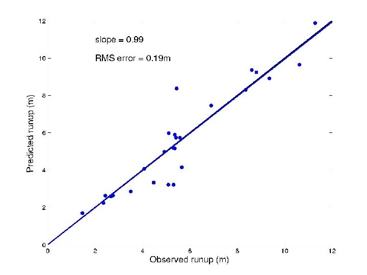
=> Model simulations recover measured runups with good accuracy [Ioualalen et al (2007)]
Task 1. 3: Simulation of transoceanic tsunamis from co-seismic sources and volcanic island flank collapse (e. g. , Cumbre Vieja Volcano; CVV) w Preliminary simulations of a Puerto Rico 9. 1 co-seismic source
Task 1. 3: Simulation of transoceanic tsunamis from co-seismic sources and volcanic island flank collapse (e. g. , Cumbre Vieja Volcano; CVV) w Preliminary simulations of a Puerto Rico 9. 1 co-seismic source
Task 1. 3: Simulation of transoceanic tsunamis from co-seismic sources and volcanic island flank collapse (e. g. , Cumbre Vieja Volcano; CVV) w Realistic CVV sources will be designed and their parameters selected, based on earlier work (e. g. , Moss et al. , 1999; Day et al. , 1999; Ward and Day, 2001; Hildenbrand et al. , 2003; Pérignon, 2006; Grilli et al. , 2006; Lovholt et al. , 2008; Abadie et al, 2009 a, c). w 3 D simulations of these subaerial landslide tsunami sources, will be performed using a multi-fluid Navier. Stokes (NS) VOF model (Abadie et al. , 2008, 2009 a, b, d). Recent surveys of CVV topography and seafloor bathymetry will be used (Abadie et al. , 2009 c). w Transoceanic propagation performed as above
Task 1. 3: Simulation of transoceanic tsunamis from co-seismic sources and volcanic island flank collapse (e. g. , Cumbre Vieja Volcano; CVV) w Preliminary work on CVV included surveys and slope stability analyses using a FEM model : => Failure parameters (geometry, 60 km 3, volume )
Task 1. 3: Simulation of transoceanic tsunamis from co-seismic sources and volcanic island flank collapse (e. g. , Cumbre Vieja Volcano; CVV) w Preliminary work on CVV source :
Task 1. 3: Simulation of transoceanic tsunamis from co-seismic sources and volcanic island flank collapse (e. g. , Cumbre Vieja Volcano; CVV) w Preliminary work on CVV source propagation :
Task 1. 4: Inundation Modeling for High Risk East Communities w Modeling will be performed using the Boussinesq wave model FUNWAVE, developed at UD. w Modeling to be carried out using high resolution DEM’s (existing or under development) where available. w Initial prioritization of communities to be based on prior studies. Subsequent choice of communities will use results from the proposed effort.
Simulation Model: FUNWAVE w Model developed at UD (fully nonlinear and dispersive Boussinesq model). w Cartesian grid version has been used extensively in studies of nearshore processes and tsunami generation/propagation/inundation (see above). w Spherical grid version available for ocean-scale simulation. Model is parallelized for efficient application. w Performance relative to PMEL-135 benchmarks will be documented separately.
Task 1. 5: Construction of Inundation maps for Modeled East Communities w Inland flood inundation maps will be based on high resolution DEMs, likely Li. DAR based, consistent with DEMs used in Task 1. 4. w Output flood maps will be created in web and print form at 1 foot increments, similar to the vertical resolution/RMSE of many large scale Li. DAR datasets. w Maps will be created using a GIS. w Flood areas will be displayed along with local area data (roads, aerial imagery)
U. Delaware / U. Rhode Island FY 10 Funding Plan/Proposal Task (Activity) Name NTHMP Performance Metric(s) (from Strategic Plan) Supported Task 1. 1 Literature Review Successful execution of NTHMP tsunami mapping, modeling, mitigation, planning and education efforts Task 1. 2 Probabilistic Analysis of SMF: Delaware - Georgia Task 1. 3 Reanalysis of previous Cumbre Vieja simulations, new simulations Task 1. 4 Methodology for determining sources based on probabilistic SMF model Amount of Requested Funds $15, 000 $60, 000 Performance Metric $50, 000
U. Delaware/ U. Rhode Island FY 10 Funding Plan/Proposal Task (Activity) Name Task 1. 5 Establish framework for DEM, GIS databases NTHMP Performance Metric(s) (from Strategic Plan) Supported Tsunami inundation maps that support informed decision making Total request for FY 10: $196, 081 Amount of Requested Funds $20, 081
U. Delaware / U. Rhode Island FY 11 Funding Plan/Proposal Task (Activity) Name NTHMP Performance Metric(s) (from Strategic Plan) Supported Amount of Requested Funds Task 1. 2 Determination of tsunami source scenarios for detailed study Performance Metric $32, 774 Task 1. 3 Ocean scale simulations for Cumbre Vieja, other sources Performance Metric $50, 000 Task 1. 4 Inundation modeling for initially selected coastal communities Performance Metric $60, 000 Task 1. 5 Map development for coastal communities Tsunami inundation maps that support informed decision making $55, 000 Total request for FY 11: $197, 774
U. Delaware / U. Rhode Island FY 12 Funding Plan/Proposal Task (Activity) Name NTHMP Performance Metric(s) (from Strategic Plan) Supported Amount of Requested Funds Task 1. 3 Simulation of additional ocean scale scenarios Performance Metric $60, 000 Task 1. 4 Inundation modeling for additional coastal communities Performance Metric $79, 854 Task 1. 5 Map development for modeled coastal communities Tsunami inundation maps that support informed decision making $60, 000 Total request for FY 12: $199, 854. Total request for project: $593, 709