MOBILE COMPUTING CSE 4081460814 Spring 2017 Cellular Positioning

MOBILE COMPUTING CSE 40814/60814 Spring 2017

Cellular Positioning: Cell ID Open-source database of cell IDs: opencellid. org

Cellular Positioning - Cell ID with TA TA: Timing Advance (time a signal takes to travel from mobile device to cell tower)

Cellular Positioning - EOTD: Enhanced-Observed Time Difference Your location is in the zone at the intersection of 3 cell circular bands

Cellular Positioning Performance • Maps of the area served by individual cell towers are complex • GSM signal reception • Attenuated by barriers • Change with call volume • Cells size varies 100 m- 30 Km • Resulting positioning is inconsistent and unreliable • Sufficient for some applications

Cellular Based Location • Development of location systems based on mobile phase was driven by US Federal Communication Commission (FCC) • The main purpose was to locate mobile phones to assist phones to deliver emergency services • Later it was also used for • Location Based services • Advertisement • Recommendation systems • Gaming

Comparing Cellular and GPS Positioning
 broadcast signals up to 100 m")
Wi-Fi Positioning Systems • Wi-Fi access points (hotspots) broadcast signals up to 100 m • Wi-Fi chips in devices detect the name of the access point, signal strength, and (sometimes) angle of arrival • Client devices can detect access points in two ways • Passively listening on 802. 11 channels for beacon frames • Initiate scan by sending requests which access points reply

Location based on 802. 11 • 802. 11 takes advantages of two properties observed by clients • Spatial variability: signal strength depends on distance & location • Temporal consistency: good chance this will be true in days/weeks/months/. . . • Map of “radio fingerprints” can be established
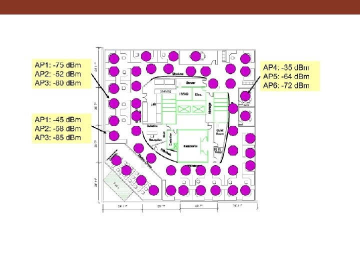
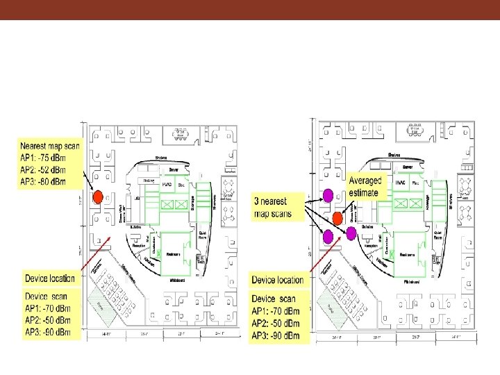

Wi-Fi Localization • Wi-Fi is everywhere now • No new infrastructure • Low cost • APs broadcast beacons • “War drivers” already build AP maps • Calibrated using GPS • Constantly updated • Position using Wi-Fi • Indoor Wi-Fi positioning gives 2 -3 m accuracy • But requires high calibration overhead: 10+ hours per building • Changes over time (adding/removing/relocating APs) impact accuracy Manhattan (Courtesy of Wigle. net)
 based on fusion")
Access to Wireless Positioning • Skyhook provides wireless positioning solution (XPS) based on fusion of GPS, Wi-Fi, and cellular • Ekahau offers a commercial solution using fingerprinting mainly for internal building positioning
")
Hybrid Positioning System (XPS)
 • Synchronized signals are broadcast from coastal stations over large geographic areas")
Radio-Navigation (LORAN) • Synchronized signals are broadcast from coastal stations over large geographic areas • Difference in the time of reception of the signals is constant along hyperbolic curves • Position calculated by intersecting curves from 2 sets of stations • Was seen as an ideal backup for GPS in case of jamming/outages • Terminated in US/Canada in 2010

Other Indoor Positioning Options • Bluetooth positioning • Used to send local messages about location/ services • RFID chips embedded in the environment • RFID scanners can check location/ services available • UWB • High precision industrial positioning of tags on items • TMSI • Temporary ID of GSM phones can be tracked for short period within small areas (e. g. , shopping centers) • IP positioning • Using structure of Internet to situate IP address geographically
")
Indoor Positioning System (IPS)

GPS vs. IPS
 •")
IPS • Beaconing: Wi-Fi, Bluetooth, . . . • RFID tags (later lecture) • Magnetic or other sensor data

Positioning Accuracy
")
i. Beacon (Apple, BLE-based)

i. Beacon • i. Beacon is the Apple Trademark for an indoor positioning system that Apple Inc. calls “a new class of low-powered, low-cost transmitters that can notify nearby i. OS devices of their presence. ” • The i. Beacon works on Bluetooth Low Energy (BLE), also known as Bluetooth Smart. BLE can also be found on Bluetooth 4. 0 devices that support dual mode.

Estimote i. Beacon • An Estimote Beacon is a small wireless device. When placed in a physical space, it broadcasts tiny radio signals to smart devices • Smartphones that are in range are able to 'hear' these signals and estimate their location very precisely, as well as to communicate with the beacon to exchange data and information

i. Beacon

i. Beacon

i. Beacon • Video: http: //www. youtube. com/watch? v=s. UIqfjp. Inx. Y • Video: http: //www. youtube. com/watch? v=Srs. HBjzt 2 E 8
 • Privacy (beacon DO NOT track users)")
i. Beacon: Advantages • Accuracy (Bluetooth, low-range) • Privacy (beacon DO NOT track users) • Integration (Apple, Android, . . . ) • Affordability (low-cost beacons, other devices can be configured as beacons) • Usability (BLE -> low energy); simple to use (built into OS/platform)

Magnetic Positioning • Magnetometer + data connection • Evaluates building’s distortion of Earth’s magnetic field or “magnetic fingerprint” • Correlates to reference data • More steel improves accuracy (1 -2 meters)

Magnetic Positioning Step 1: Adding floor plans Step 3: Creating applications Step 2: Mapping buildings

Smartphone Positioning

Future for Positioning • Combination/fusion of multiple positioning techniques is now norm • Focus on energy efficiency • Focus on indoor localization • Dead reckoning (accelerometer/gyroscope) when no GPS • “Snapping” of location (“natural” boundaries) • Cooperative localization • Applications: • Asset tracking: RFID • Geo-fencing: alerts • Emergency response • Social networking • Health/Wellness
- Slides: 31