Mississippi River Introduction The Mississippi River derived from


 Benny (6) Andrew (9) Kin (13)")
- Slides: 44
Mississippi River
Introduction The Mississippi River, derived from the old Ojibwe word misi-ziibi meaning 'big river' (gichiziibi in the modern language), is the secondlongest river in the United States; the longest is the Missouri River, which flows into the Mississippi. Taken together, they form the largest river system in North America. If measured from the head of the Missouri, the length of the Missouri/Mississippi combination is approximately 6, 270 km (3, 900 miles) long.
Mississippi delta from space
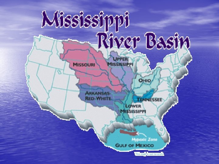
The Mississippi River has the third largest drainage basin in the world, exceeded in size only by the watersheds of the Amazon River and Congo River. It drains 41 percent of the 48 contiguous states of the United States. The basin covers more than 1, 245, 000 square miles (3, 225, 000 km²), including all or parts of 31 states and two Canadian provinces.
The Mississippi drains most of the area between the Rocky Mountains and the Appalachian Mountains, except for the area drained by the Great Lakes. It runs through, or borders, ten states in the United States , for example, Minnesota, Wisconsin, Iowa, Illinois, Missouri, Kentucky, Arkansas, Tennessee, Mississippi and Louisiana.
The river is divided into the upper Mississippi, further divided into three sections: the from its source south to the Ohio River, and the lower Mississippi, from the Ohio to its mouth near New Orleans. The upper Mississippi is headwaters, from the source to Saint Anthony Falls; a series of man-made lakes between Minneapolis and St. Louis; and the middle Mississippi, a relatively free-flowing river downstream of the confluence with the Missouri River at St. Louis.
Speed At the headwaters of the Mississippi, the average surface speed of the water is near 1. 2 miles per hour - roughly one-third as fast as people walk. At New Orleans, on 2/24/2003, the speed of the river was 3 miles per hour.
Width At Lake Itasca, the river is between 20 -30 feet wide, the narrowest stretch for its entire length. The Mississippi is more than four miles wide at Lake Onalaska. Near La. Crosse, Wisconsin, Mississippi water held behind Lock and Dam #7 and water held back by damming the Black River combine to form this broad reach of the Mississippi River
Depth At its headwaters, the Mississippi is less than 3 feet deep. The river's deepest section is between Governor Nicholls Wharf and Algiers Point in New Orleans where it is 200 feet deep.
Elevation The elevation of the Mississippi at Lake Itasca is 1, 475 feet above sea level. It drops to 0 feet above sea level at the Gulf of Mexico. More than half of that drop in elevation occurs within the state of Minnesota.
Sediment Load The Mississippi carries an average of 436, 000 tons of sediment each day. Over the course of a year, it moves an average of 159 million tons of sediment. Averages have ranged from 1, 576, 000 tons per day in 1951 to 219, 000 in 1988.
Volume At Lake Itasca, the average flow rate is 6 cubic feet per second. At Upper St. Anthony's Falls, the northernmost Lock and Dam, the average flow rate is 12, 000 cubic ft/second. At New Orleans, the average flow rate is 600, 000 cubic feet per second
Wildlife The Mississippi River and its floodplain are home to a diverse population of living things: At least 260 species of fishes, 25% of all fish species in North America; Forty percent of the nation's migratory waterfowl use the river corridor during their Spring and Fall migration; Sixty percent of all North American birds (326 species) use the Mississippi River Basin as their migratory flyway; The Upper Mississippi is host to more than 50 species of mammals; At least 145 species of amphibians and reptiles inhabit the Upper Mississippi River environs.
The source of the Mississippi River on the edge of Lake Itasca
Impacts of flooding in Mississippi Introduction • A flood is defined as the temporary overflow of a river onto adjacent lands not normally covered by water. The most devastating flood in U. S. 1. 2. history occurred in the summer of 1993. The Mississippi River at St. Louis, Missouri, was above flood stage for 144 days between April 1 and September 30, 1993. Approximately 3 billion cubic meters of water overflowed from the river channel onto the floodplain downstream from St. Louis.
3. All large Midwestern streams flooded including the Mississippi, Missouri, Kansas, Illinois, Des Moines and Wisconsin rivers. 4. Seventeen thousand square miles of land were covered by floodwaters in a region covering all or parts of nine states (North Dakota, South Dakota, Nebraska, Kansas, Missouri, Iowa, Wisconsin, Minnesota, Illinois).
Causes of Flooding There were four principal reasons why flooding was so extensive: • The region received higher than normal precipitation • during the first half of 1993. Much of the area received over 150% of normal rainfall and parts of North Dakota, Kansas, and Iowa received more than double their typical rainfall. ; Individual storms frequently dumped large volumes of precipitation that could not be accommodated by local streams. The map on the right shows rainfall in Iowa over a two-day period. Over six inches of rain fell in parts of southern Iowa;
• The ground was saturated because of cooler than • normal conditions during the previous year (less evaporation) so less rainfall was absorbed by soils and more ran-off into streams; The river system had been altered over the previous century by the draining of riverine wetlands and the construction of levees.
Weather Conditions • The abnormal rainfall was attributed to a weather system formed when warm moist air from the Gulf of Mexico collided with cold, dry air from Canada over the Midwest. When the warm Gulf air cooled it lost the moisture it carried as rain. Normally this rainfall would have been distributed throughout the northeastern states but a stalled high-pressure system over the southeast blocked the flow of the jet-stream bringing a constant stream of storms over the Midwest. For nearly two months (June, July) weather patterns in the U. S. were dominated by this stationary high-pressure system (see diagram below).
Mississippi River System • The Mississippi River is divided into two parts. The Upper Mississippi runs from it source to Thebes, southern Illinois, where the Ohio river meets the Mississippi. The Lower Mississippi runs downstream from Thebes to the Gulf of Mexico. Flooding was confined to the Upper Mississippi because the river channel widens considerably south of Thebes, and the Lower Mississippi received lower than average inflow from tributaries.
Discharge increases steadily downstream as more tributaries add water to the river. The map on the left shows the locations of four gaging stations and the graph above illustrates how discharge increases on the river between its source and St. Louis. The large increase near St. Louis is caused by the addition of the flow of the Missouri River. Click here to go to a satellite view of flooding on the Mississippi and Missouri Rivers near St. Louis.
Modification of the Mississippi River • The Mississippi River is one of the most heavily engineered natural features in the U. S. The character of the floodplain has changed to accommodate agriculture and urbanization. Approximately 80% of the original wetlands along the river were drained since the 1940’s. Wetlands act as natural storage reservoirs for floodwaters. They absorb water during heavy precipitation and release it slowly thus reducing run-off to streams and decreasing flood volumes. The river channel itself has been artificially constrained by levees and floodwalls. These structures serve to increase the volume of water that can be held in the channel and thus increase the size of the flooded area if the levee breaks.
Upper Mississippi River in July, 1992 Upper Mississippi River in July, 1993 Two satellite views of the Mississippi River (Lake Michigan is on the right) show the change in size of the river related to the 1993 flood. Larger views of both images can be viewed at the Federal Goernment’s SAST (Scientific Assessment and Strategy Team) site. We can either attempt to stop natural hazards from occurring (prevention) or recognize that they will happen and modify our life styles to deal with them (adjustment).
Prevention • There are two principal ways that engineers have attempted to • control the flow of rivers in the Mississippi River basin: 1. Build levees or floodwalls to contain rising stream levels; 2. Build reservoirs on tributary streams to store floodwaters for later release. Steps taken to adjust to flood events include: 1. Purchasing flood insurance though the National Flood Insurance Program; 2. Seek assistance from the Federal Emergency Management Agency (FEMA) following a flood event. The U. S. Army Corps of Engineers were given directions to construct flood control structures (dams, reservoirs, levees) on the Mississippi River following flood events in the 1930’s. Levees may fail because the flood water rises over the top of the structure or the levee collapses under the weight of the water. Levees and floodwalls protect people on the floodplain from most floods. However, they may not protect against the largest floods with recurrence intervals of more than 100 years. Floodplain residents may experience a false sense of security that can lead to more extensive development of flood prone lands (the "levee effect").
Over 9, 300 km of levees were damaged following the 1993 flood. Only 17% of federal levees were damaged, but up to 77% of locally constructed levees failed. Most levee breaks occurred south of St. Louis was protected by a massive floodwall. The wall developed a leak but held up over the length of the flood. Over 50 propane tanks containing over a million gallons of gas in south St. Louis presented the threat of a massive explosion. A levee break south of the city allowed the river level to drop around St. Louis and reduced pressure on the propane tanks. Many of the smaller levees in rural areas failed.
• Large dams and reservoirs on the Mississippi River would hinder transportation. Therefore, the majority of flood control structures in the Upper Mississippi River basin are located in the Missouri River basin. The Missouri basin can be further subdivided and most of the dams are located in a southern subbasin, the Kansas River basin. Approximately 85% of stream flow in the Kansas basin is controlled, i. e. it flows through dams. Locations of dams on tributary streams in the Kansas River basin.
Adjustment • Approximately 10% of Midwest residents who lived in flood-prone areas had flood insurance prior to the 1993 floods. Over eleven million buildings are located in floodprone areas in the U. S. but only 19% purchased flood insurance. • FEMA was created in 1979 to provide financial assistance to people and areas affected by natural disasters. Over 400 counties in the flood region were declared disaster areas, making them eligible for disaster relief. Not all areas affected by flooding are declared disaster areas. Residents who don't buy flood insurance must gamble that they will receive disaster aid from FEMA to help cover clean up costs.
People and the Flood • Nearly fifty people died as a result of the flooding, 26, 000 were evacuated and over 56, 000 homes were damaged. Economic losses that are directly attributable to the flooding totaled $10 -12 billion. Indirect losses in the form of lost wages and production can not be accurately calculated. Further consequences of flooding: 1. Economic and Social aspect 2. Psychological aspect 3. Political aspect
Economic and Social aspect • The greatest economic losses occurred in cities on the • floodplain. Des Moines, Iowa, located in the center of the flood region, became the largest U. S. city to lose its water supply when its water treatment plant flooded. More than 250, 000 people lost drinking water for 19 hot summer days. Water pipes, contaminated by floodwaters carrying sewage and agricultural chemicals, had to be flushed out before the municipal water supply was reconnected. Economic losses in Des Moines totaled approximately $716 million. The flooding submerged eight million acres of farmland. Production of corn and soybeans were down 5 -9% as a result and corn prices rose by $0. 15 per bushel. Floods deposited thick layers of sand in some fields. The U. S. Soil Conservation Service spent $25 million to buy flood-prone farmlands for conversion to natural conditions (e. g. wetlands). Conversion of natural lands to farmlands has resulted in greater run-off and exaggerated the effects of flooding. Modern farming methods leave plant residue on the surface and reduce run-off.
• The Mississippi River itself is a crucial part of the Midwest’s economic infrastructure. Barge traffic normally moves goods through a system of 29 locks between Minneapolis and St. Louis. Barges carry 20% of the nation’s coal, a third of its petroleum, and half it exported grain. Barge traffic was halted for two months; carriers lost an estimated $1 million per day. Some power plants along the river saw their coal stocks dwindle from a two-month supply to enough to last just 20 days. • Hundreds of miles of roads built on the flat, wide floodplain were closed. Flooding is estimated to have cost $500 million in road damage • Many facilities were damaged, reconstruction is necessary. This may stop the development of the society.
Psychological aspect • People are suffer from fear. They lost their homes, properties and families. They were psychologically seriously hurt. They lost their relatives and these are a treasure of priceless worth and irrecoverable.
Political aspect • The government rule will become unstable. They cannot provide a good prevention system for the flooding and made the society suffer from serious destruction. People blamed the government. The government need to carry out relief work immediately to appease the victims of a natural disaster.
Pro/Con Arguments • Like almost all complex environmental issues, there are pro and con arguments to this issue. There are both positive and negative human and environmental consequences to attempts to manage the Midwest's rivers.
Pro Arguments • 1. Maintenance of a Navigation Channel – Major rivers of the Mississippi River system are vital routes for barge traffic. To maintain and improve navigation, the Army Corps of Engineers has straightened, shortened, and deepened parts of the river via dredging and construction of locks and dams. Sandbars, snags, and navigation hazards are regularly removed and the Corps has an extensive network of navigation buoys on the rivers. Use of the rivers as routes for barge traffic is essential to the commerce and economy of the Midwest.
• 2. Flood Protection – People, property, businesses, industry, and agricultural crops are at risk from the inevitable floods along the rivers. The Army Corps of Engineers has developed a monumental network of levees, dikes, berms, and floodwalls along the banks of the rivers intended to protect humans and human structures and enterprises from the threats of floods. These flood protection measures have been highly successful in the smaller, more frequent floods, but may actually exacerbate the very large, less frequent floods (see below).
• 3. Enhanced Utilization of Floodplains – The extensive levee system along more than 3, 000 miles of Midwest rivers has allowed greater human utilization of floodplain lands adjacent to the rivers. This land has been developed for agricultural, industrial, commercial, and residential purposes. Without the levee system, many of these areas, often wetlands, would have been less suitable for human development. Also without the levee system, these areas would have been subject to frequent flooding. This third benefit also has negative consequences, as described below.
Con Arguments • 1. Reduced Alluvial Soil Deposition – The fertility of floodplain soils is due in large part to deposition of new soils by periodic floods. Since the levee system prevents rivers from spreading out over floodplains and depositing their sediment load, deposition of fertile new soil is blocked.
• 2. Human Developments in Natural Floodplains – Human habitation and development in floodprone areas are invitations to disaster. The levee and floodwall system along Midwest rivers has encouraged development in floodplains and often provided a false sense of security. When floods do top or break levees in developed areas, the resultant damage is severe and costly.
• 3. Loss of Wetland Riparian Ecosystems – Until fairly recently, wetlands were regarded as useless lands. Most of the former wetland areas of the Mississippi River system have been drained, developed, and protected by levees. Wetlands are now recognized as biologically rich areas worthy of preservation. Riparian ecosystems are those natural areas immediately adjacent to rivers. Like wetlands, riparian zones are ecologically valuable. With human development and levee construction, much of the riparian areas along Midwest rivers have been lost or altered.
• 4. Exacerbation of Major Floods – While the levee system has been effective in containing small floods, the levees may actually increase the severity of major floods. Levees prevent the rivers from spreading out over their natural floodplains. If a river spreads out over a large floodplain area, then the height of the water's rise during a flood is relatively small. However, if a river is not allowed to spread out over a floodplain, then the water will rise much higher in the artificially narrowed river channel. Higher water levels may top existing levees, resulting in flooding and calls for ever-higher levees.
• 5. Enhanced Soil Erosion and Sediment Load – Natural riparian zones help to trap soil eroding from lands adjacent to rivers. Loss of natural riparian zones results in more soil entering riverways by erosion. The amount of sediment a river carries is proportional to water velocity in the river. Because major rivers of the Midwest have been straightened, deepened, and artificially confined to narrow channels, water velocity and hence sediment load have increased. More and more precious topsoil from Midwest farms is being carried out into the Gulf of Mexico.
• 6. Adverse Impacts on Aquatic Life – Dredging of major rivers of the Midwest is commonplace to maintain the rivers as navigation channels. Dredging severely impacts benthic, or bottom-dwelling, species. Species found in the water column are adversely affected by the increased turbidity resulting from greater sediment loads found in the rivers. Loss of riparian and wetland areas and chemical and nutrient pollution have also adversely impacted the biota of Midwest rivers. The overall effect of these human-related changes has been to decrease the biological richness of aquatic ecosystems in the Mississippi River system.
END 6 A Gary (1) Benny (6) Andrew (9) Kin (13)