
Mississippi Mineral Resources Institute State of the Institute
- Slides: 25
Mississippi Mineral Resources Institute State of the Institute MMRI Advisory Board February 12, 2015
AGENDA 10: 30 am Welcome – Greg Easson, Director • Introductions of staff and board members • Expectations from the board • Duties of a board member 10: 45 am Summary of activities of MMRI – Greg Easson • MMRI goals and objectives • Summary of funding and personnel changes • Current emphasis areas • Feedback from the Board 11: 45 am LUNCH 12: 30 pm 1: 00 pm 1: 30 pm 2: 00 pm 2: 30 2: 45 Marine Research activities – Carol Lutken Seafloor mapping and research activities – Marco D’Emidio Marine Technical Services – Steven Tidwell Terrestrial research activities – Charles Swann Geospatial Information Science and Technology activities – Allison Woolsey Board discussion and Closing remarks – Greg Easson
Expectations and Duties of a Board Member Feedback: As you listen to the different presentations today, answer the following questions: • How appropriate is the project or activity in light of the MMRI mission • From the sector that you represent, what type of research and/or education is missing and should be done? • How do the research and/or educational activities presented today contribute to the needs of your sector? • Email with the questions will follow the meeting
Expectations and Duties of a Board Member Expectations: • Review MMRI research and education activities • Suggest new research activities • Support MMRI efforts for funding to support research and education • Provide feedback to Director Duties • Stay informed of MMRI activities • Attend two meetings per year • Contact the Director about any issue (662 -915 -5995 or geasson@olemiss. edu)
MMRI Goals • Promote mineral resource and environmental research and education • Provide academic background and expertise to industry, academia and government • Promote transfer of technology • Ensure appropriate training by providing educational opportunities, experience and support
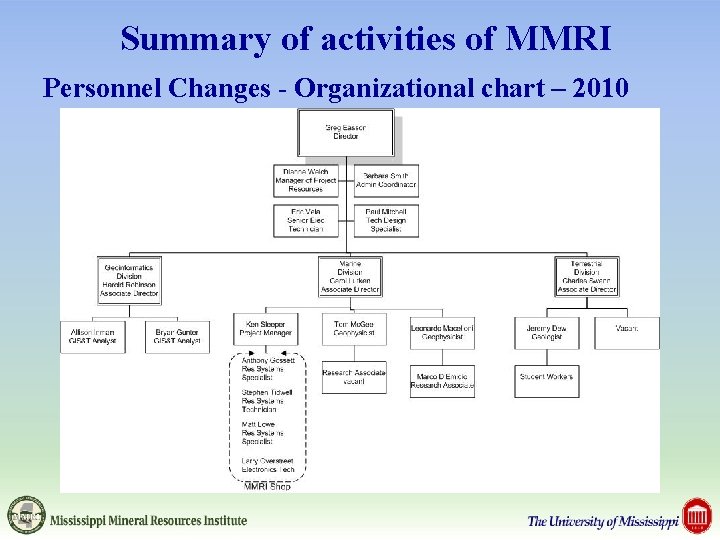
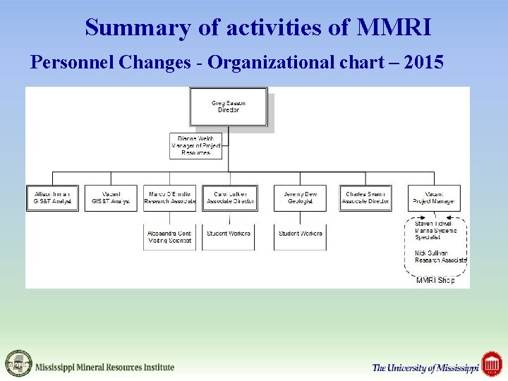
Summary of activities of MMRI • Research focus areas • Changes and additions • Funding Changes • Personnel Changes • Educational activities • Student research • Funding opportunities
Summary of activities of MMRI Marine Research: • Investigation of gas hydrate dynamics • Design of a deep sea observatory • Develop novel marine mapping systems and technology • New techniques for collecting and processing geophysical and bathymetric data • Marine data collection technology – design, fabrication, deployment and recovery
Summary of activities of MMRI Terrestrial Research: • Geologic investigation needed to promote wise use of Mississippi’s resources • Hazard mitigation investigations and analysis • Geological mapping for resource assessment • Engineering geological mapping for site assessment and economic development • Energy resource assessment • Industrial mineral investigations
Summary of activities of MMRI Geospatial Information Science and Technology: • Application of GIS and remote sensing to a range of natural resources issues • Extracting data from imagery for modeling and analysis • Creating seamless datasets for coastal analysis • Imagery maps for general use • Graduate student research
Summary of activities of MMRI Energy resources and production research: • Research and data for industry and research needs • Ridgway Data Center – 40, 000+ well logs online • Oil and gas research • Tuscaloosa Marine Shale research • Eutaw/Austin Chalk investigation • Proppant sand • Suitability of Mississippi sands for ‘fracking’ • Geospatial analysis of water use and availability
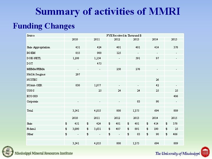
Summary of activities of MMRI Funding Changes Source 2010 2011 FYE Received in Thousand $ 2012 2013 2014 2015 State Appropriation 451 424 401 414 378 BOEM 855 900 125 - - - 1, 108 1, 154 - 591 97 - 258 276 - - DOE-NETL DOT 475 MEMA/FEMA - NASA Seagrass 297 - NCITEC 26 NOAA-OER 830 1, 077 USGS 25 - - 42 - 24 24 25 25 ECOGIG 406 Corporate Total - - 3, 541 4, 055 2010 2011 808 2012 83 90 - 1, 375 694 809 2013 2014 2015 State $ 451 $ 424 $ 401 $ 414 $ 378 Federal $ 3, 090 $ 3, 631 $ 407 $ 891 $ 190 $ 25 Other $ - $ - $ 83 $ 90 $ 406 3, 541 4, 055 808 1, 375 694 809
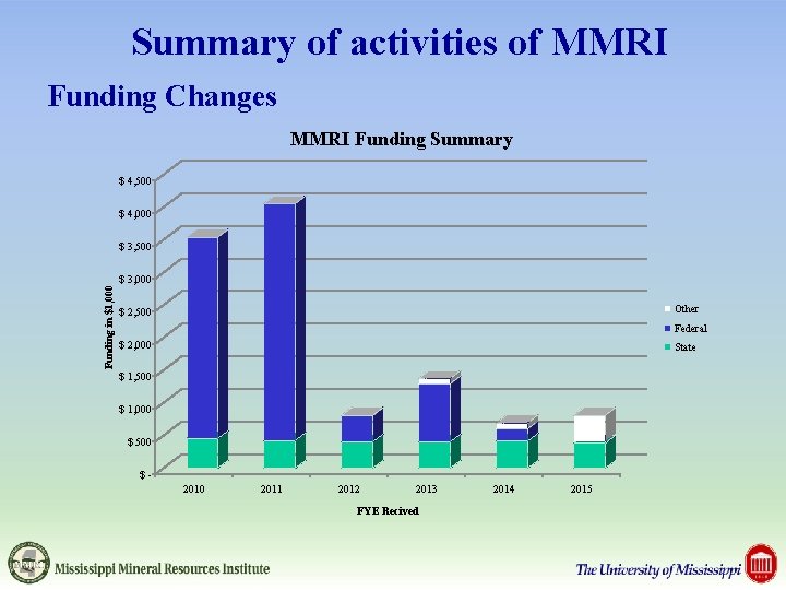
Summary of activities of MMRI Funding Changes MMRI Funding Summary $ 4, 500 $ 4, 000 $ 3, 500 Funding in $1, 000 $ 3, 000 Other $ 2, 500 Federal $ 2, 000 State $ 1, 500 $ 1, 000 $ 500 $2010 2011 2012 2013 FYE Recived 2014 2015
Summary of activities of MMRI Personnel Changes - Organizational chart – 2010
Summary of activities of MMRI Personnel Changes - Organizational chart – 2015
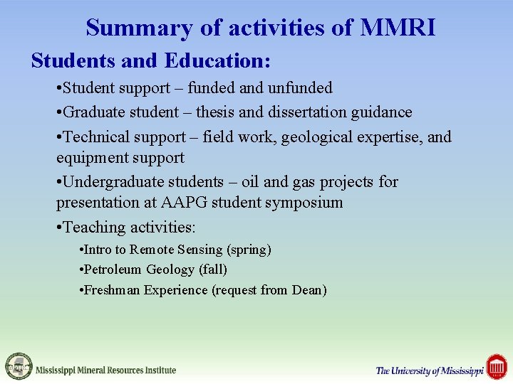
Summary of activities of MMRI Students and Education: • Student support – funded and unfunded • Graduate student – thesis and dissertation guidance • Technical support – field work, geological expertise, and equipment support • Undergraduate students – oil and gas projects for presentation at AAPG student symposium • Teaching activities: • Intro to Remote Sensing (spring) • Petroleum Geology (fall) • Freshman Experience (request from Dean)
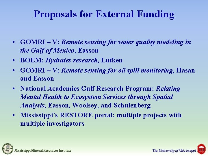
Proposals for External Funding • GOMRI – V: Remote sensing for water quality modeling in the Gulf of Mexico, Easson • BOEM: Hydrates research, Lutken • GOMRI – V: Remote sensing for oil spill monitoring, Hasan and Easson • National Academies Gulf Research Program: Relating Mental Health to Ecosystem Services through Spatial Analysis, Easson, Woolsey, and Schulenberg • Mississippi’s RESTORE portal: multiple projects with multiple investigators
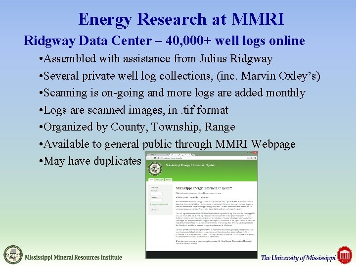
Energy Research at MMRI Ridgway Data Center – 40, 000+ well logs online • Assembled with assistance from Julius Ridgway • Several private well log collections, (inc. Marvin Oxley’s) • Scanning is on-going and more logs are added monthly • Logs are scanned images, in. tif format • Organized by County, Township, Range • Available to general public through MMRI Webpage • May have duplicates
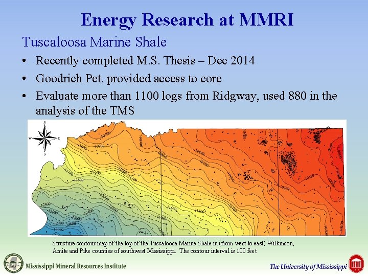
Energy Research at MMRI Tuscaloosa Marine Shale • Recently completed M. S. Thesis – Dec 2014 • Goodrich Pet. provided access to core • Evaluate more than 1100 logs from Ridgway, used 880 in the analysis of the TMS Structure contour map of the top of the Tuscaloosa Marine Shale in (from west to east) Wilkinson, Amite and Pike counties of southwest Mississippi. The contour interval is 100 feet
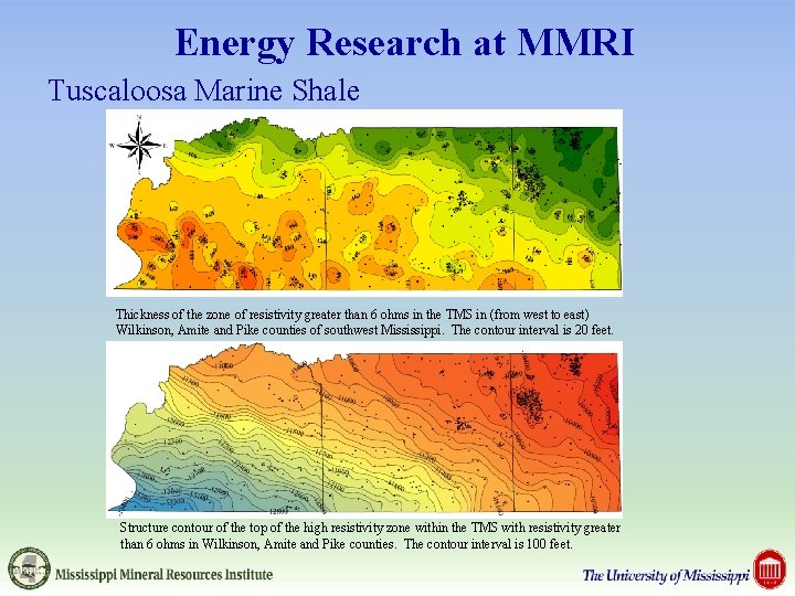
Energy Research at MMRI Tuscaloosa Marine Shale Thickness of the zone of resistivity greater than 6 ohms in the TMS in (from west to east) Wilkinson, Amite and Pike counties of southwest Mississippi. The contour interval is 20 feet. Structure contour of the top of the high resistivity zone within the TMS with resistivity greater than 6 ohms in Wilkinson, Amite and Pike counties. The contour interval is 100 feet.
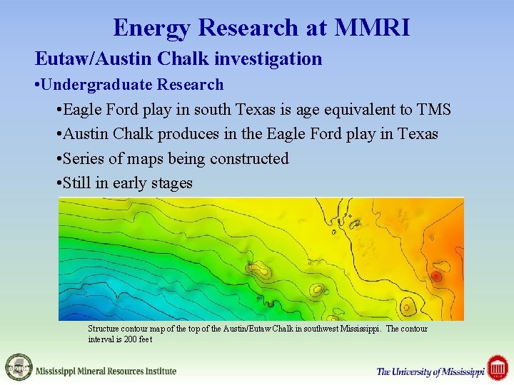
Energy Research at MMRI Eutaw/Austin Chalk investigation • Undergraduate Research • Eagle Ford play in south Texas is age equivalent to TMS • Austin Chalk produces in the Eagle Ford play in Texas • Series of maps being constructed • Still in early stages Structure contour map of the top of the Austin/Eutaw Chalk in southwest Mississippi. The contour interval is 200 feet
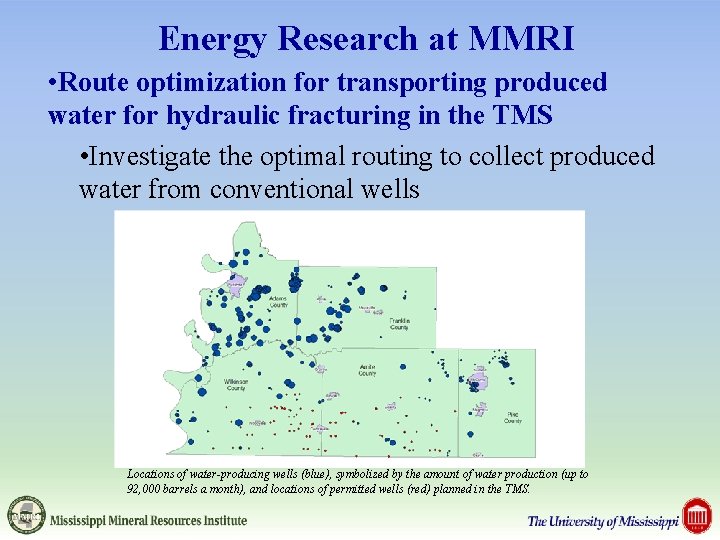
Energy Research at MMRI • Route optimization for transporting produced water for hydraulic fracturing in the TMS • Investigate the optimal routing to collect produced water from conventional wells Locations of water-producing wells (blue), symbolized by the amount of water production (up to 92, 000 barrels a month), and locations of permitted wells (red) planned in the TMS.
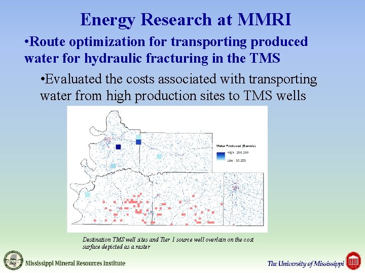
Energy Research at MMRI • Route optimization for transporting produced water for hydraulic fracturing in the TMS • Evaluated the costs associated with transporting water from high production sites to TMS wells Destination TMS well sites and Tier 1 source well overlain on the cost surface depicted as a raster
Energy Research at MMRI Student research in initial phases • Undergraduate Research • Reconstruction of the TMS depositional surface • Study area is 6 counties in southwest Mississippi • Early stages, goal to present at AAPG student symposium • Graduate Research • Distribution of oolitic and oomoldic porosity in the Brooklyn field, Alabama • Investigation of the Norphlet in the Brooklyn field, Alabama
Other Student Research at MMRI • Graduate Research • Interferometric Synthetic Aperture Radar (If. SAR) as a tool to investigate surface subsidence • Bayou Corn sink hole collapse from salt mining, • Investigating the surrounding geology and conditions at other wells in the field • Integrating optical and microwave data for soil moisture measurement in agricultural environments • Builds on research performed in New Mexico, part of a groundwater recharge study • Investigating the impact of vegetation on measurement accuracy • Study area is the Mississippi Delta
Thank You Mississippi Mineral Resources Institute 111 Brevard Hall University, Mississippi 38677 Greg Easson (geasson@olemiss. edu) 662 -915 -5995 www. mmri. olemiss. edu