Microwave Emission Signature of SnowCovered Lake Ice Martti
- Slides: 27

Microwave Emission Signature of Snow-Covered Lake Ice Martti Hallikainen(1), Pauli Sievinen(1), Jaakko Seppänen(1), Matti Vaaja(1), Annakaisa von Lerber(1), Erkka Rouhe(1), Juha Lemmetyinen(2) (1)Aalto University School of Electrical Engineering (2)Finnish Meteorological Institute International Geoscience and Remote Sensing Symposium 2011 IGARSS 2011

Contents Test site and data collection Experimental data: - Brightness temperature (TB) values - TB differences between selected frequencies - TB differences between vertical and horizontal polarization Conclusions IGARSS 2011

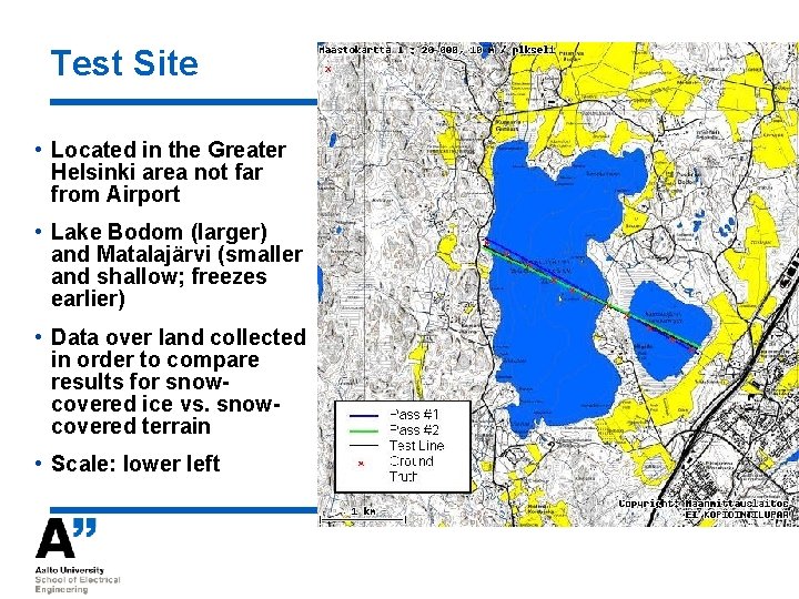
Test Site • Located in the Greater Helsinki area not far from Airport • Lake Bodom (larger) and Matalajärvi (smaller and shallow; freezes earlier) • Data over land collected in order to compare results for snowcovered ice vs. snowcovered terrain • Scale: lower left

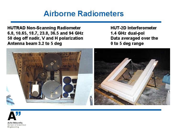
Airborne Radiometers HUTRAD Non-Scanning Radiometer 6. 8, 10. 65, 18. 7, 23. 8, 36. 5 and 94 GHz 50 deg off nadir, V and H polarization Antenna beam 3. 2 to 5 deg kkkkkkkkkkkkkk HUT-2 D Interferometer 1. 4 GHz dual-pol Data averaged over the 0 to 5 deg range

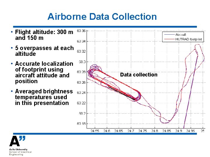
Airborne Data Collection • Flight altitude: 300 m and 150 m • 5 overpasses at each altitude • Accurate localization of footprint using aircraft attitude and position • Averaged brightness temperatures used in this presentation Data collection

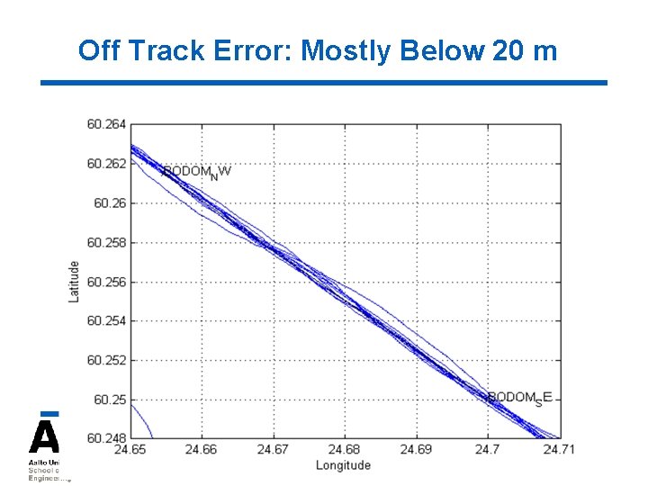
Off Track Error: Mostly Below 20 m

Airborne Data 2004: April 7 2007: January 30, March 26, April 2 2011: January 27, February 28, March 31 (am/pm), April 14 Data include dry snow conditions and snow/ice melting period Data collected with HUTRAD radiometer (6. 8 to 36. 5 / 94 GHz) April 14, 2011 data collected with HUTRAD and HUT-2 D (1. 4 GHz) Results from 2011 flights discussed in this presentation

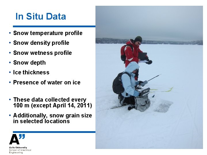
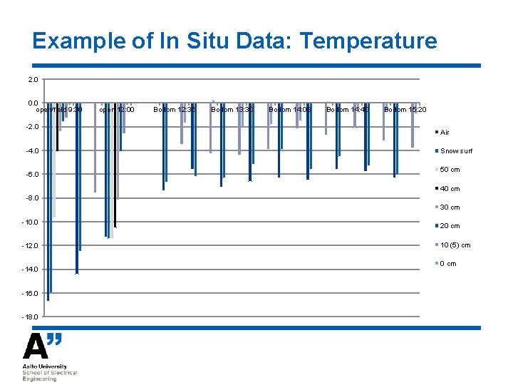
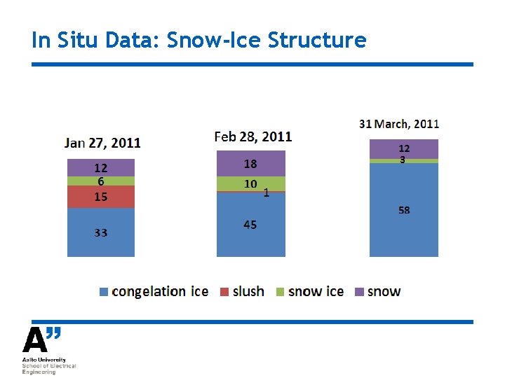
In Situ Data • Snow temperature profile • Snow density profile • Snow wetness profile • Snow depth • Ice thickness • Presence of water on ice • These data collected every 100 m (except April 14, 2011) • Additionally, snow grain size in selected locations

Example of In Situ Data: Temperature 2. 0 0. 0 open/field 9: 30 -2. 0 -4. 0 -6. 0 open 12: 00 Bodom 12: 35 Bodom 13: 30 Bodom 14: 08 Bodom 14: 40 Bodom 15: 20 Air Snow surf 50 cm 40 cm -8. 0 30 cm -10. 0 -12. 0 -14. 0 -16. 0 -18. 0 20 cm 10 (5) cm 0 cm

In Situ Data: Snow-Ice Structure

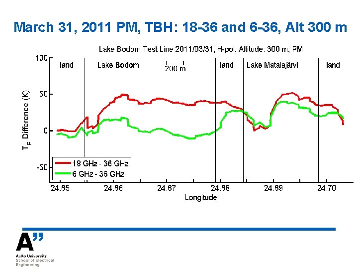
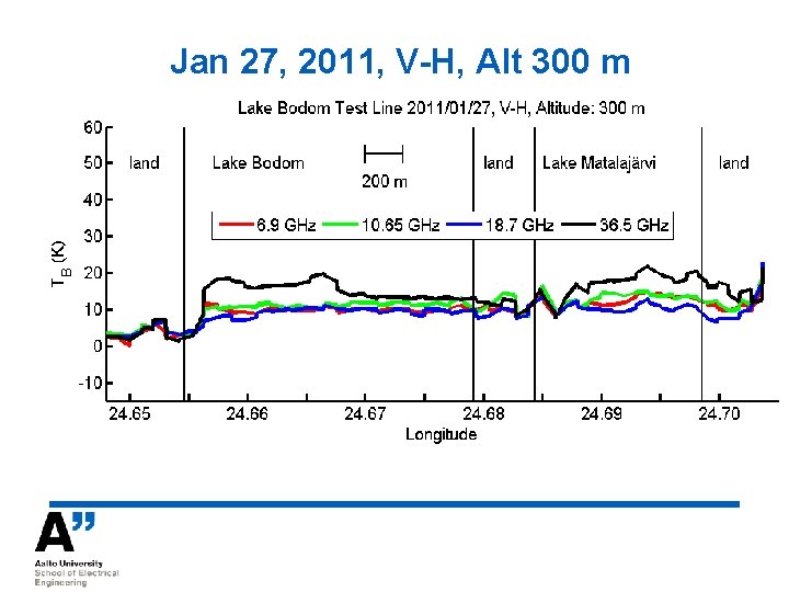
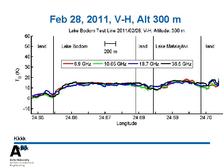
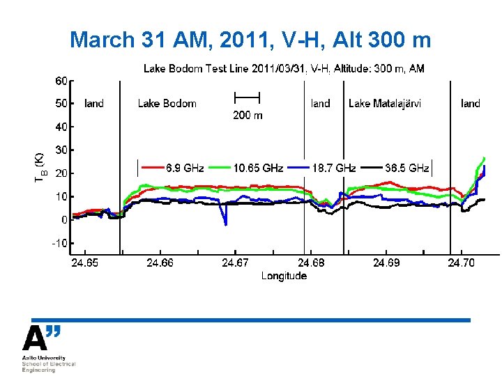
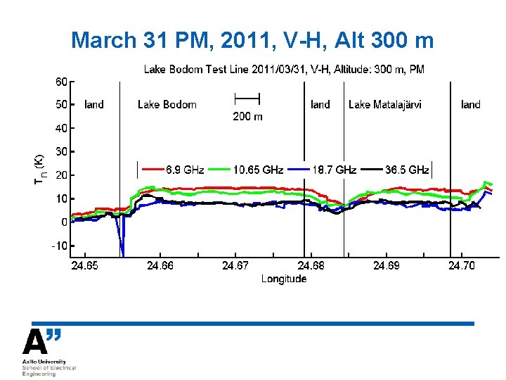
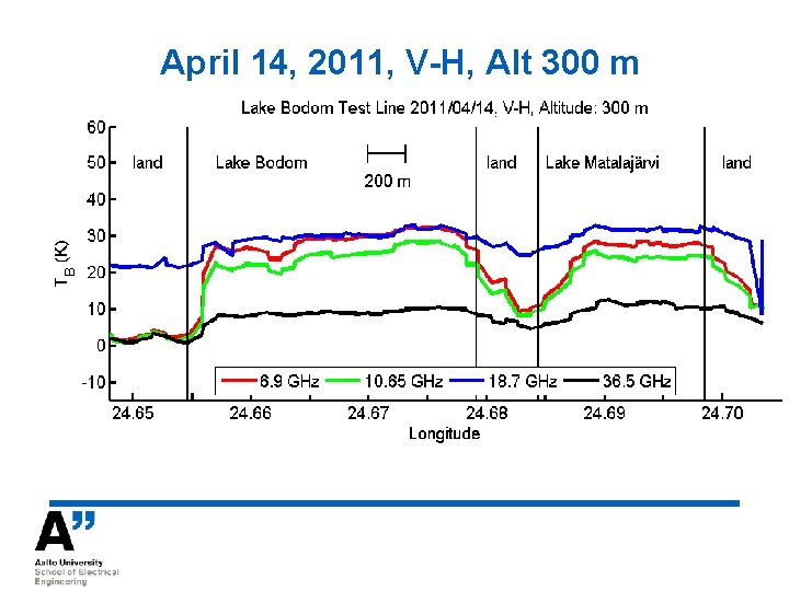
Results from Radiometer Measurements Brightness temperatures at 6. 8, 10. 65, 18. 7 and 36. 5 GHz (April 14: also 1. 4 GHz) (18. 7 GHz: occasional interference) Horizontal polarization (V-pol not shown) TB differences between 18. 7 / 36. 5 GHz, and 6. 8 / 36. 5 GHz TB differences between vertical and horizontal polarization at each frequency (except 1. 4 GHz)

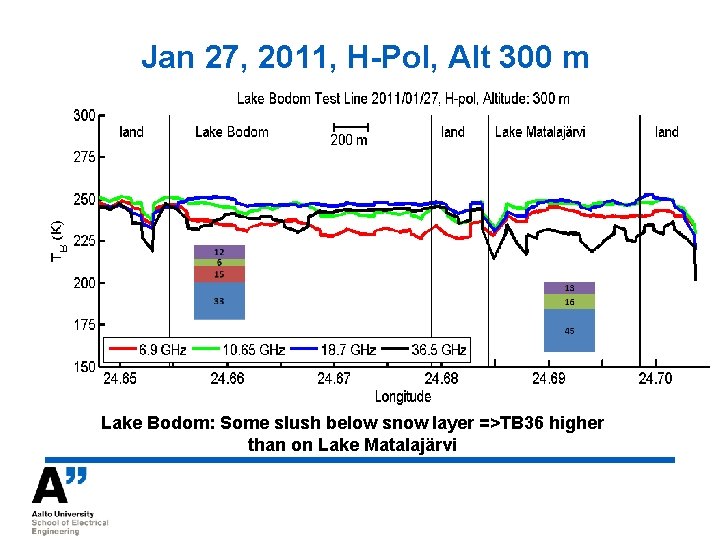
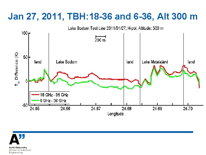
Jan 27, 2011, H-Pol, Alt 300 m Lake Bodom: Some slush below snow layer =>TB 36 higher than on Lake Matalajärvi

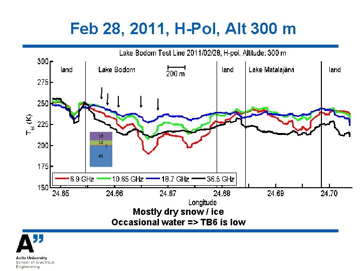
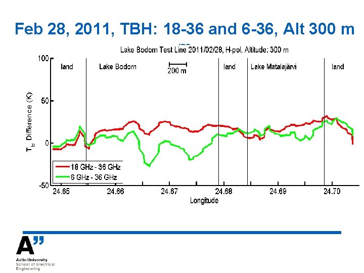
Feb 28, 2011, H-Pol, Alt 300 m Mostly dry snow / ice Occasional water => TB 6 is low

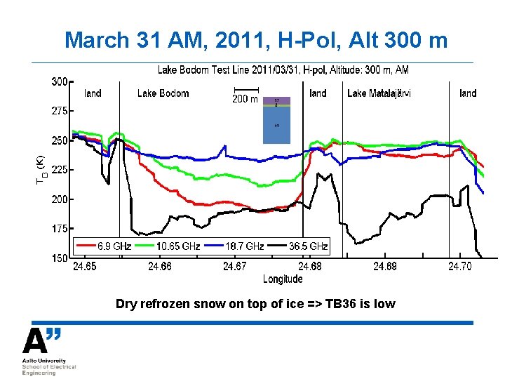
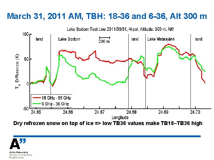
March 31 AM, 2011, H-Pol, Alt 300 m Dry refrozen snow on top of ice => TB 36 is low

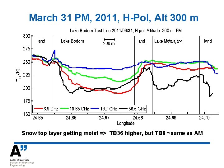
March 31 PM, 2011, H-Pol, Alt 300 m Snow top layer getting moist => TB 36 higher, but TB 6 ~same as AM

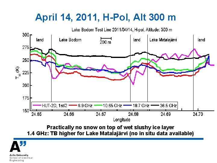
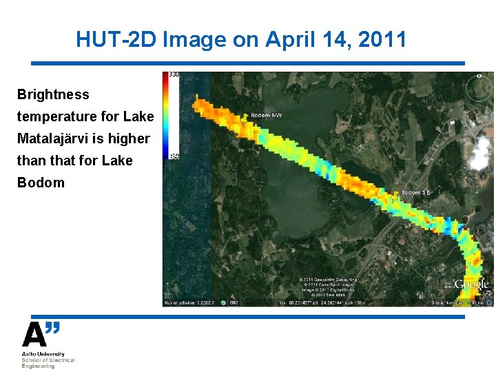
April 14, 2011, H-Pol, Alt 300 m Practically no snow on top of wet slushy ice layer 1. 4 GHz: TB higher for Lake Matalajärvi (no in situ data available)

HUT-2 D Image on April 14, 2011 Brightness temperature for Lake Matalajärvi is higher than that for Lake Bodom

Jan 27, 2011, TBH: 18 -36 and 6 -36, Alt 300 m

Feb 28, 2011, TBH: 18 -36 and 6 -36, Alt 300 m m

March 31, 2011 AM, TBH: 18 -36 and 6 -36, Alt 300 m Dry refrozen snow on top of ice => low TB 36 values make TB 18–TB 36 high

March 31, 2011 PM, TBH: 18 -36 and 6 -36, Alt 300 m Kkkk

Jan 27, 2011, V-H, Alt 300 m

Feb 28, 2011, V-H, Alt 300 m Kkkkk

March 31 AM, 2011, V-H, Alt 300 m Kkkk

March 31 PM, 2011, V-H, Alt 300 m

April 14, 2011, V-H, Alt 300 m

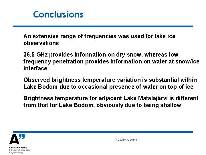
Conclusions An extensive range of frequencies was used for lake ice observations 36. 5 GHz provides information on dry snow, whereas low frequency penetration provides information on water at snow/ice interface Observed brightness temperature variation is substantial within Lake Bodom due to occasional presence of water on top of ice Brightness temperature for adjacent Lake Matalajärvi is different from that for Lake Bodom, obviously due to being shallow IGARSS 2011